Description
Traverse of the "Seraia" peak 3900 m above sea level
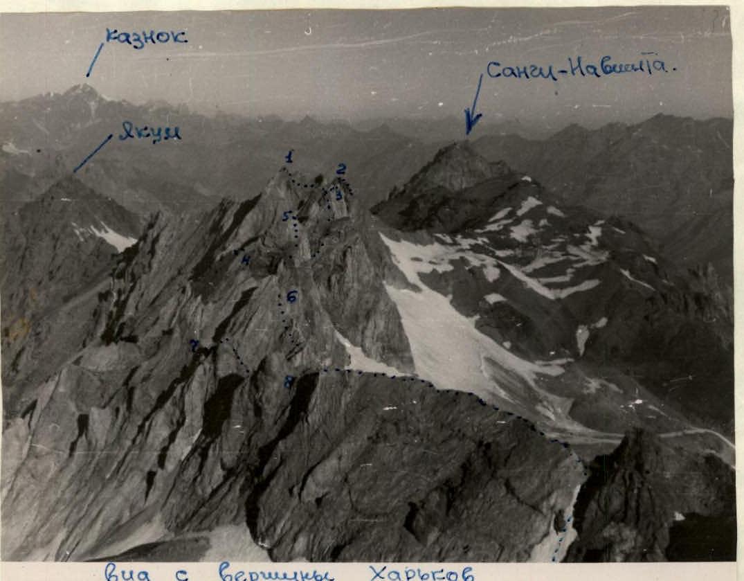
The "Seraia" peak is located in the Southern spurs of the Gissar ridge to the north of Dushanbe city. The ridge of "Seraia" stretches from west to east for a length of 3.5–4 km. The ridge has a remarkably distinctive character in its structure. Being on the same ridge as the "Yakum" peak, which consists of pure granites, the ridge of "Seraia" consists of marbleized limestone, which greatly complicates the organization of piton belay.
The ridge consists of three peaks: the Main (or Western) peak (which is the highest), the Middle peak, conditionally called the "Main Gendarme", and the Eastern peak, named by the first ascenders, army climbers, as "Chortov palets" (Devil's Finger).
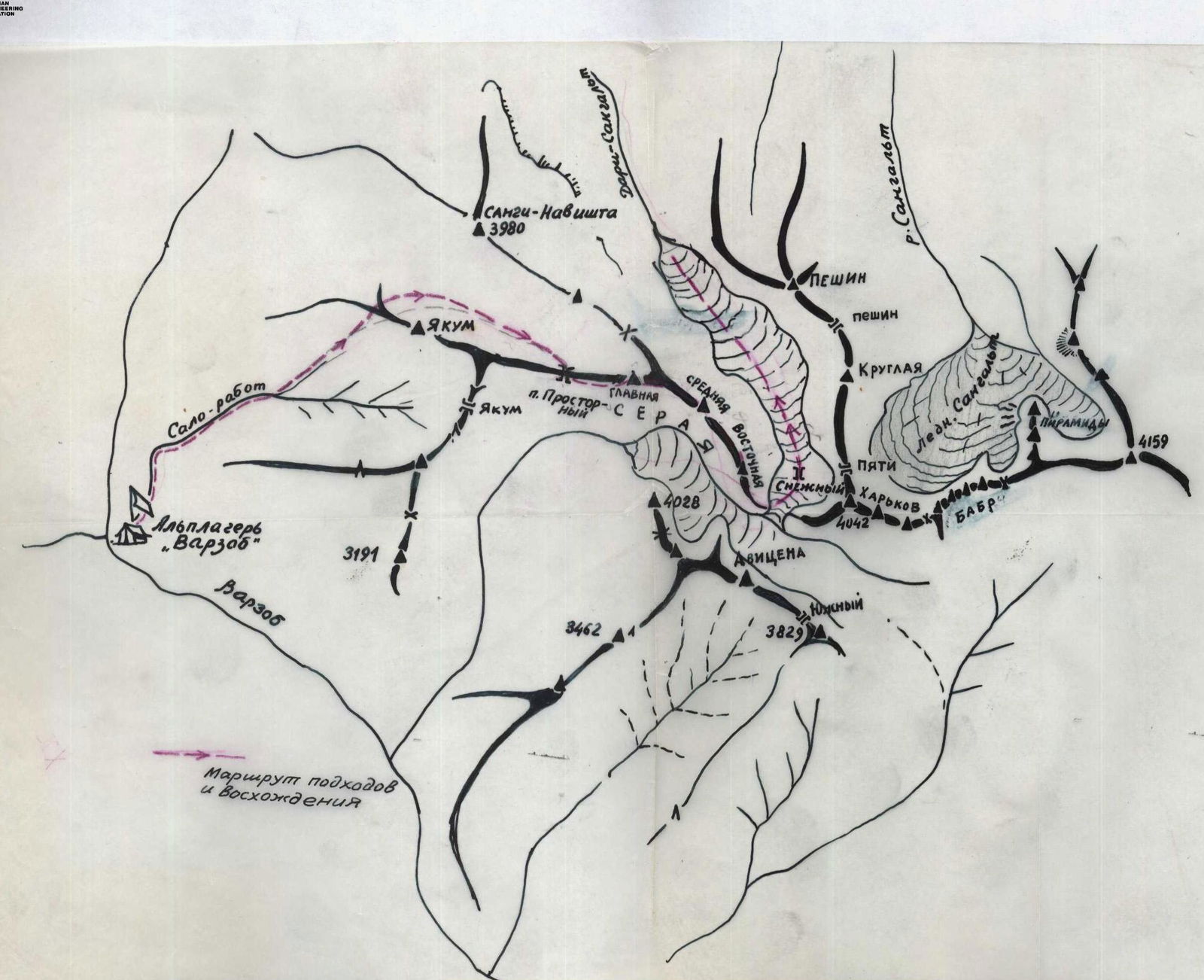
The approaches to the ridge of "Seraia" are most conveniently made from the "Varzob" alpine camp along the Salo-Rabot river valley. After two fifty-minute transitions, we reach the first large right tributary and start ascending up along its left bank, following the trail.
The trail leads to the ridge, which leads to the Yakum peak. At the border of rocks and grassy slopes, we cross the ridge and start traversing the slopes on the other side with a slight gain in altitude. The path is easy here. Then we enter the northern cirque of Yakum peak and, continuing to move east along the ridge of "Seraia", we reach the "Prostorny" pass. It is convenient to set up a base camp at this pass. This pass connects two snowy cirques, and therefore it is completely windless here; from here, the most difficult sections of the ascent to the "Main Gendarme" are visible.
The path from the base camp initially goes through the snowy cirque to a small saddle on the ridge to the west of the Main peak. The slopes of the cirque are initially not steep - 20–30°, then, three rope lengths from the saddle, the slope becomes steeper and there is formed ice. In August, a small depression forms here between the walls of the peak and the snow - similar to a bergschrund. The steepness increases noticeably.
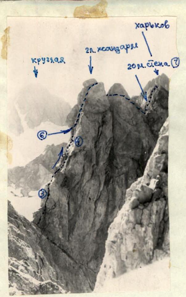
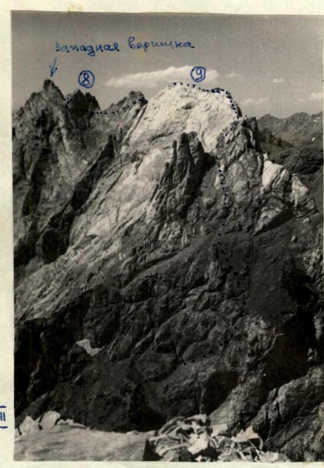
The first person in the rope team crosses the section on crampons. Belay is provided through ledges. On the saddle, crampons are removed, and the group puts on climbing shoes, as it is difficult to work on rocks consisting of marbleized limestone in crampons - they often slip (see 1). Immediately from the saddle, we start the path along a not very steep wall 50–60°, consisting of good holds; the ascent follows a not clearly defined crack. On a small platform, a piton belay is organized for the next climber. The length of the wall is 35–40 m, then the path follows ledges on the ridge, and after 25–30 minutes, we reach the first "Western peak". The path from the base camp to the Western peak takes 2–2.5 hours. The descent from the Western peak initially goes east (see 11) along the ridge for the first 100–120 m, then "gendarms" (8) are encountered on the way, ending in a 10–12 m wall. The "gendarms" consist of a pile of small marbleized slabs, which are unsuitable for movement, as they can cause a rockfall, so at the beginning of the "gendarms" it is necessary to descend from the ridge to the south for 2–2.5 rope lengths. A small counterfortress departs from the "gendarms" to the south, which then turns into a wall. At 2–2.5 rope lengths from the gendarms, there is a small groove in the counterfortress, descending to the southeast. The groove is strewn with loose stones, and the walls of the groove consist of marbleized cracked limestone. It is necessary to descend along the groove with careful top belay. Having descended 5–6 m down, it is necessary to cross over the left side of the groove and, traversing to the left along a not steep wall, enter a gap on the ridge. The wall has a steepness of 40–45°, it is a kind of rocky slope strewn with small flat slabs, which is extremely dangerous for movement. Belay on this section is provided through small ledges resembling mushrooms protruding from the wall (rocky slope).
From the gap on the ridge, we traverse 25–30 m below the ridge to a gap between the next "gendarms" encountered on the way. The path follows not clearly defined shelves, this section is not difficult, but extremely dangerous, as the described wall (rocky slope) breaks off to the south with a 700 m wall 60 meters from the ridge. From the gap, there is a small descent along the wall with a clearly defined crack and good holds to a small triangular platform; there is snow here.
At this place, the ridge makes a bend to the northeast with a knee bend of 300 m, and then again heads east. The height of the wall is 5–6 m. After the triangular snow platform, we move along easy rocks, and then along rocks of medium difficulty and reach the ridge. The ridge is extremely dangerous for movement, as it consists of small slabs and breaks off to the north with rocky cornices. Therefore, it is necessary to move below the ridge 5–8 m on the south side of the ridge, i.e., to the right of the direction of movement, making a traverse of the pre-ridge wall with a steepness of 50–60°. Having passed along the ridge for 250–300 m, we start descending down the ridge to a depression on the ridge before the second peak "Main Gendarme". Before the very gap, there is a section of descent along a wall of medium difficulty, 20 m long. There is a good platform for rest in the gap, and from here the route of one of the difficult sections of the traverse is visible - the ascent along an 80–90 m wall to the "Main Gendarme" (see III and 13).
Initially, the path to the "Main Gendarme" follows a wall with a crack turning into a chimney (3) under a large stone (2). Here, the lead climber organizes a piton belay. There is a platform for four people near the large stone. From here, the path goes around the stone to the left with a traverse above a 300-meter wall, and then with an ascent along a 10–12 m wall to a crack (4), which is very convenient for movement, as it is located on the wall as if horizontally, it is quite wide. In its upper part, the whole group can fit in it. The section from the large stone to the upper part of the crack is 35–40 m. Belay is provided through ledges and huge stones jammed in the crack.
From here, the path goes up to a groove descending to the left of the summit tower to a huge overhanging plug (5). Under the plug, there is a small inclined platform 12–15 m. The plug is followed by a 350-meter wall to the north. The lead climber must drive pitons under the plug in the wall. Then he takes in the rest of the rope team.
Then, standing on each other's shoulders, they drive in the next belay piton and, using the piton as a hold, with great difficulty climb onto the plug. This section is very difficult (6), as the overhanging plug is negative and has no holds except for small loose stones on it. Behind the plug, the path follows an inclined groove under the summit tower, which is very steep, and it is necessary to hold onto the wall of the groove (left side). The length of this section - from the plug to the pre-summit tower - is 28–80 m. On the "Main Gendarme" peak, there is a second cairn. Behind the peak, a very difficult gendarme is encountered on the ridge, which is bypassed to the left with a traverse along a 40 m wall along a very faintly defined shelf; this section is extremely difficult and requires careful piton belay.
Having bypassed the gendarme, we reach a saddle under the ridge. From here, it is still necessary to overcome one more wall with a small traverse to the left and up to the ridge along a 20 m wall (see 7). The wall (7) is of medium difficulty, but with good holds. Belay is provided through a ledge under the wall on the ridge, as there is nowhere to drive a piton. Then the movement is carried out (see II) along the ridge with simultaneous movement of the rope teams (9). The ridge descends to a saddle under the third peak "Chortov palets". The path is not difficult, and we reach the saddle along easy rocks. It is convenient to organize an overnight stay here. The path from the base camp to the saddle under the "Chortov palets" peak takes 8–10 hours.
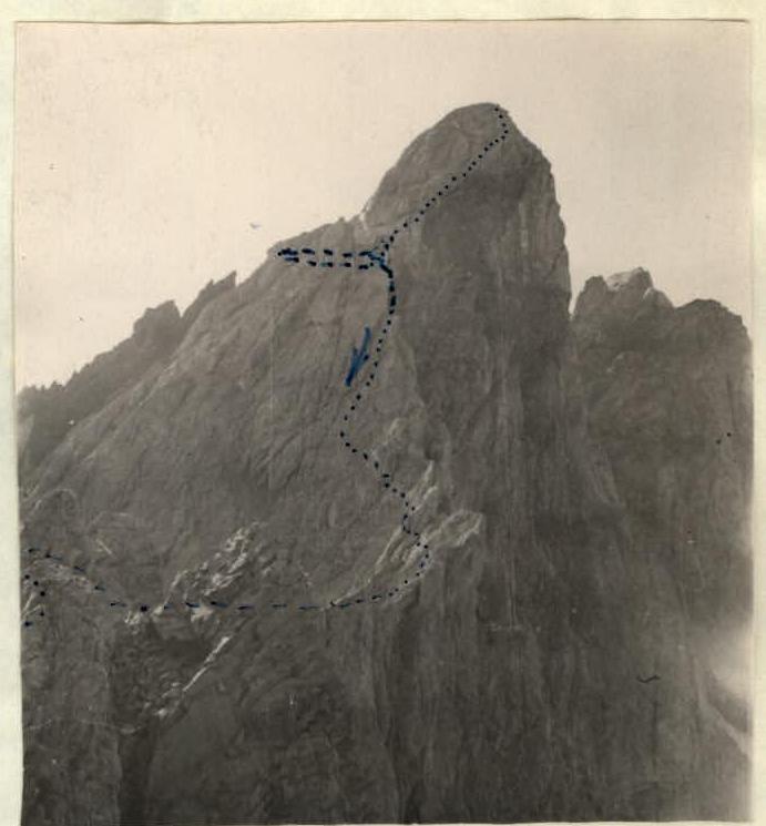
From the saddle, we initially move along the ridge for 100–150 m, and then, traversing to the left along easy rocks under the wall, we reach the southwestern counterfortress of the "Chortov palets" peak. Having passed 200 m, we approach a wide couloir. At the couloir, the walls are as follows: the right wall is made of black rocks, and the left wall is made of white rocks. We traverse the couloir and exit to its right side, onto the black rocks, and along a 60 m wall of medium difficulty, we reach the ridge of the counterfortress. The ridge is easy, and we reach the third peak in height along it. There is a cairn here. Then we start descending.
The descent (see V) is very difficult, as there are many loose large and small stones on a wall with a steepness of 60–70°. There is a faintly defined crack on the wall. Belay is top-rope. The descent along the wall is 90–100 m.
Then, along rocks of medium difficulty, we descend to a depression on the ridge. Here, on the way, a "gendarme" is encountered, which is bypassed along shelves to the right. Having bypassed the gendarme, we encounter a groove 4–5 m wide and 50 m long. We descend along a small wall (5 m) into the groove and move to its middle, then traverse 30 m below the ridge and exit to a small gap before the next gendarme. Here, a difficult section is encountered (see VI). The gendarme is bypassed to the left. Initially, we descend along a small groove to the northern side of the ridge along a wall to a shelf. Then, behind the shelf, there is a 200 m wall, and the shelf overhangs the abyss. Here, huge rocky boulders seem to be piled up. With careful belay by throwing a rope around the boulders with intermediate piton belay, we traverse along the northern wall, bypassing the gendarme; the length of the path is 35–40 m. The exit under the gendarme is especially difficult; at the end of the specified section, it is necessary to crawl lying under the overhanging rocky cornice of the "gendarme" above the abyss. Then there is an easy exit to the ridge. Here, the group gathers on a small platform.
Ahead, there is a descent along a wall of medium difficulty, also littered with loose stones. The lead climber descends with top belay, driving in a piton for belay for the next climber; having passed the section, it is necessary to move to the left and shelter, protecting oneself from stones. Then the path follows the ridge with small rocky sections. The path from the last gendarme is logical. Ahead, on the final section of the route, there is a clear landmark - a rocky tower of reddish-brown color in the white limestone ridge of "Seraia". The length of the ridge from the last "gendarme" is about one and a half kilometers.
In the middle of the ridge from the last "gendarme" there is one control cairn. The first ascenders spent 16 working hours on the complete traverse.
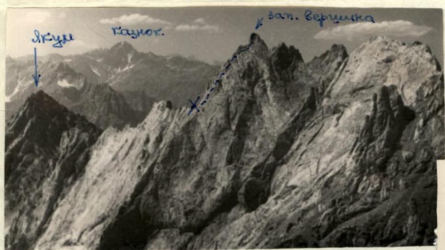 I. x - start of the traverse; exit to the western peak by a path invisible from here.
First ascenders:
- PAN'KOV R.
- AVER'YANOV V.
- GETMAN I.
- IVANNINOV V.
Recommendations for subsequent climbers:
- The number of participants in the group is no more than four people.
- Time of departure for the ascent is 3:00.
- Initial bivouac is "Prostorny" pass.
- Special equipment for a group of four people: a) main rope 2 × 40 m; expendable cordelette - 10 m; b) rock pitons - 16 pcs.; c) ice pitons - 2 pcs.; d) steel hammers - 2 pcs.; e) carabiners - 12 pcs.; f) crampons - 2 pairs.
- Places for possible bivouacs: 1 - before the Main peak, 2 - on the saddle, 3 - "Chortov palets" peak.
The first ascenders evaluate the route as category 4B.