70
Description of the Traverse
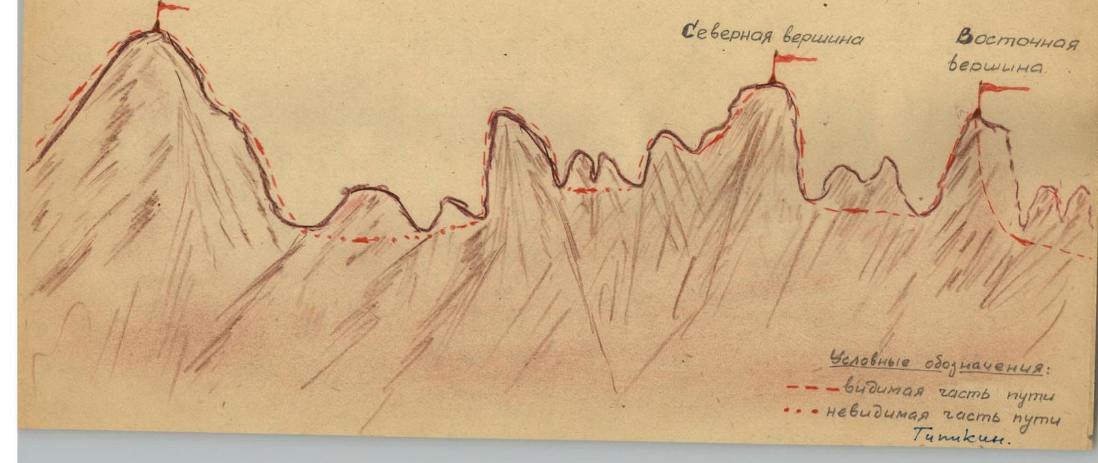
3 peaks of "Wings of Tajikistan" 2B cat. sl. A group from the "Varzob" tourist camp crosses to the right bank of the "Varzob" river and moves upstream until the first stream (after Siama) flows into the "Varzob" river. The stream originates under the saddle between "Varzobskaya Pila" and the "Wings of Tajikistan" peak. The path goes up the stream:
- initially along the scree (on the right side of the path),
- then along the snow,
- the ascent to the saddle is again along the scree.
Overnight stay is organized at convenient platforms. From the bivouac, the movement is westward along the ridge.
Small gendarmes are bypassed on the left. The snowy ridge leads to the base of the eastern peak.
- The first gendarme is bypassed on the left
- The second is taken "head-on"
We approach the eastern peak from the south, bypassing the pre-summit gendarme on the snow. We ascend to the tower of the peak along a vaguely defined groove. We reach the eastern peak in 2–2.5 hours.
Descent is made to the west:
- initially along the groove halfway,
- then, traversing to the right, we descend to a snowfield. Further movement is along the ridge:
- initially along the rocks,
- then along the snowy slope, we reach the southern ridge of the middle peak
- and ascend to the peak along moderately difficult rocks.
Descent from the peak is along the southwest side of the ridge on difficult rocks.
After the middle peak, a gendarme is encountered, which is bypassed on a slightly inclined shelf on the right. Further descent is along the slabs.
Descent along the negative wall is made "sitting on a rope." The rope is secured to a ledge. There is a platform at the bottom for those descending. The next three gendarmes are bypassed on the right along the snowfield.
Further actions include:
- ascent along moderately difficult and difficult rocks along the ridge,
- reaching inclined slabs,
- approaching moderately difficult rocks,
- ascending to the Western peak.
Descent from the peak is along a snowfield with a slope of 25–30°. Then, traversing the southern slopes of the "Wings of Tajikistan," we exit to the left onto the saddle to the overnight stay site.
Time Calculation
- Ascent to the saddle — 4.5 hours.
- Approach to the Eastern peak — 1 hour.
- Ascent to the Eastern peak — 2 hours.
- Ascent to the Middle peak — 1.5 hours.
- Ascent to the Western peak — 2 hours.
- Exit to the overnight stay site — 1.5 hours.
- Return — 2.5 hours.
Total: — 14.5 hours.
Necessary Equipment
| Rock pitons | – 5 |
|---|---|
| — ice pitons | – 1 |
| Rock hammers | – 2 |
| Slings | – 5 m. |
Description compiled by: Vaksman E.G.

"Wings of Tajikistan"
(view from the south)
Western peak