ASCENT DOCUMENT
- Type of ascent — rock climbing.
- Ascent area — Pamir-Alay, spur of the Hissar mountain range, Khodzha Mofrach.
- Peak, its height, ascent route — unnamed, 4400 m, via the North Ridge (Kazan University Peak).
- Difficulty category — 3A.
- Route characteristics: a. height difference — 220 m. b. average steepness — 40°. c. length of sections: total — 365 m, 2nd difficulty category — 210 m, 3rd difficulty category — 140 m, 4th difficulty category — 15 m.
- Pitons used: rock — 5, ice — none, bolted — none, nut/hex — 2.
- Number of climbing hours from bivouac to summit — 4 hours, no overnight stays.
- Name and qualification of the team leader and participants:
Shibalov S.L. — 1st sports category Maslennikov A.S. — — «—» Kozhevnikov O.L. — — «—» Trapeznikov A.N. — — «—» Khusaenov N.M. — — «—» Spiridonov V.V. — — «—»
- Team coach — Kudryashov V.S., instructor-methodologist 3rd category, Candidate for Master of Sports.
- Date of departure and return — July 14, 1980.
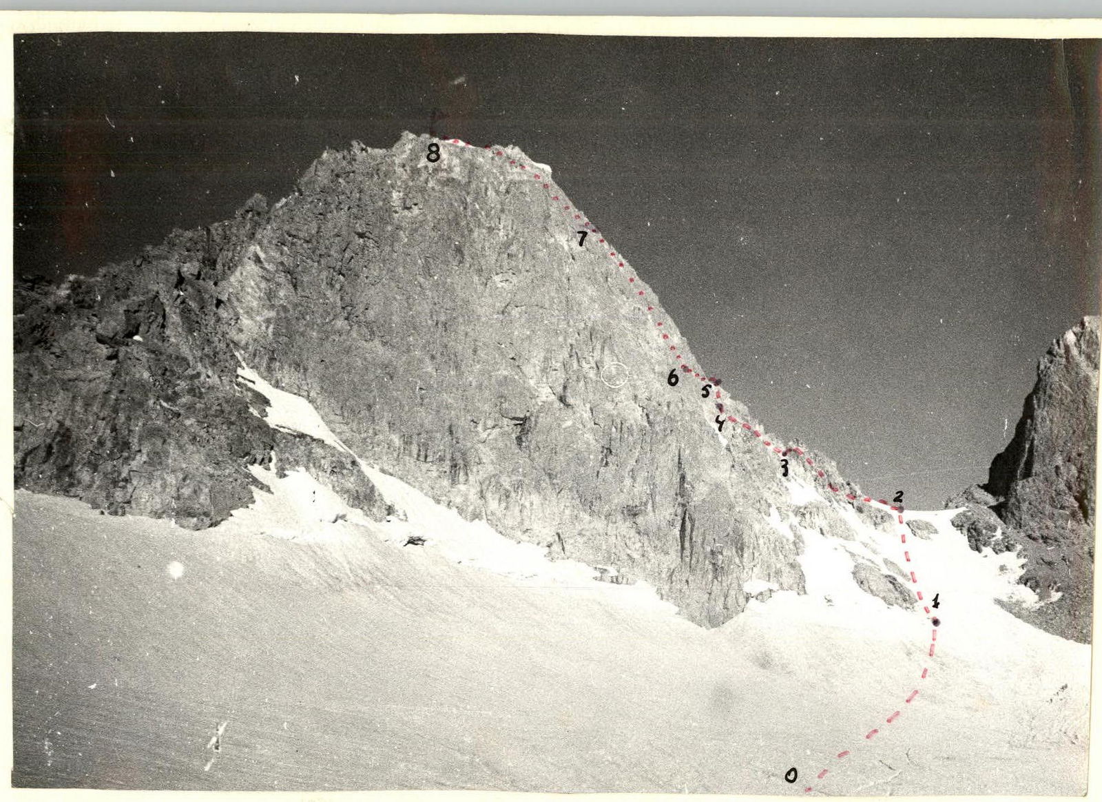
Photo 1. General view of the 4400 m peak. Ascent route. Invisible ascent path.
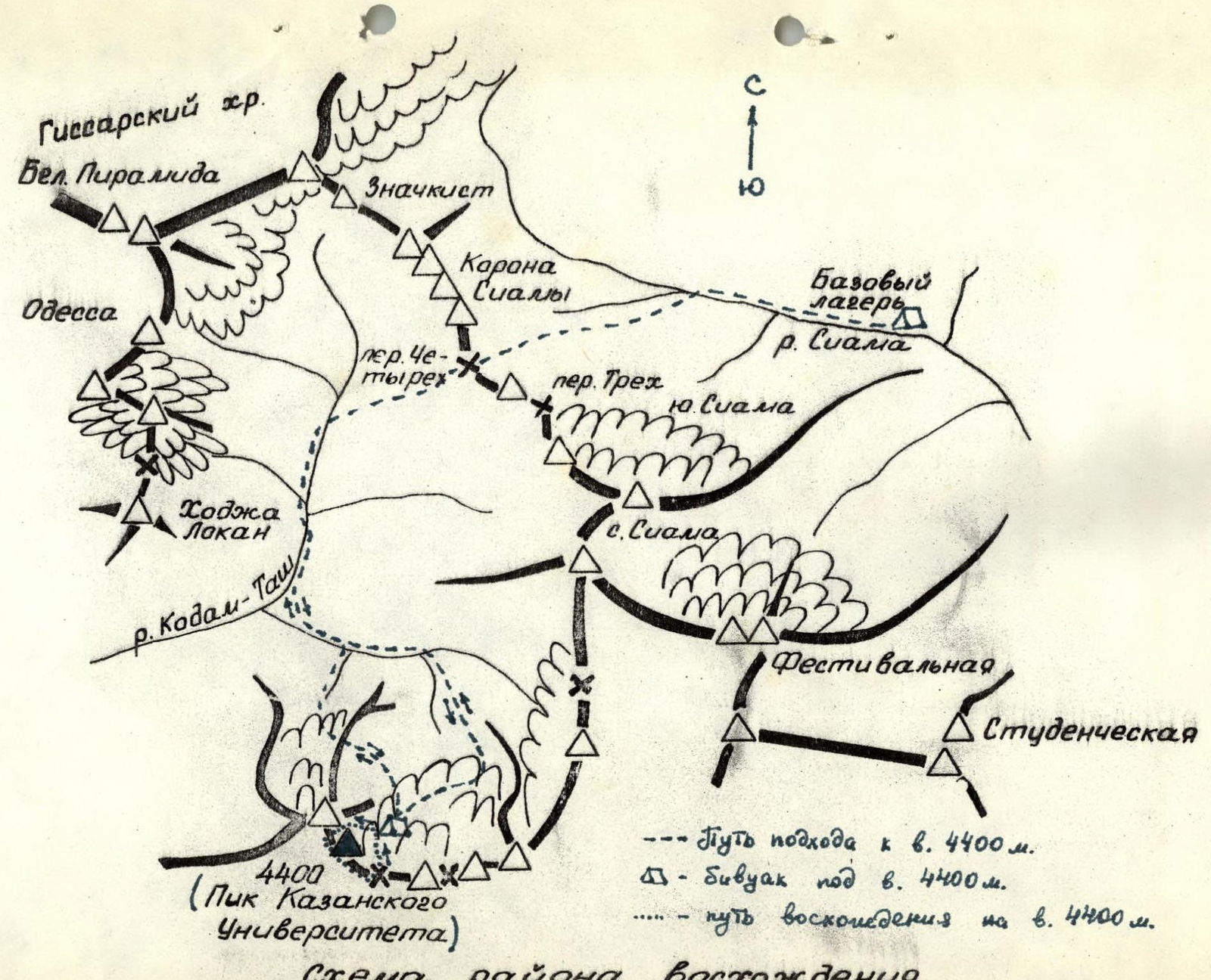
ASCENT AREA SCHEME
- Path to the 4400 m peak.
- Bivouac below the 4400 m peak.
- Ascent route to the 4400 m peak.
TABLE OF MAIN ROUTE CHARACTERISTICS
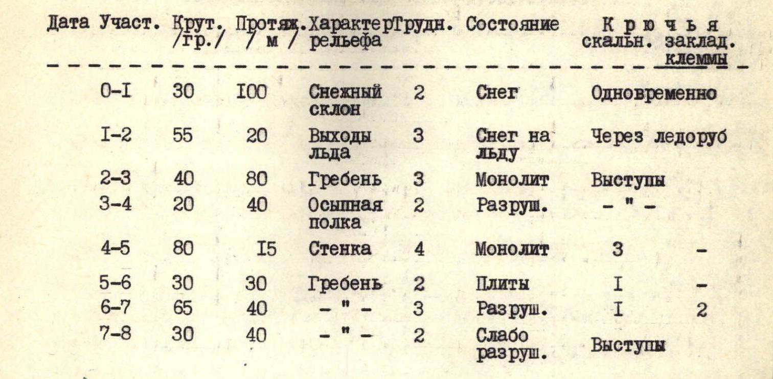
| Section | Steepness, ° | Length, m | Terrain type | Difficulty category | Condition | Rock pitons | Nut/hex |
|---|---|---|---|---|---|---|---|
| R0–R1 | 30 | 100 | Snow slope | 2 | Snow | ||
| R1–R2 | 55 | 20 | Ice outcrops | 3 | Snow on ice | ||
| R2–R3 | 40 | 80 | Ridge | 3 | Monolith | ||
| R3–R4 | 20 | 40 | Scree shelf | 2 | Unstable | ||
| R4–R5 | 80 | 15 | Wall | 4 | Monolith | 3 | |
| R5–R6 | 30 | 30 | Ridge | 2 | Slabs | 1 | |
| R6–R7 | 65 | 40 | Ridge | 3 | Unstable | 1 | 2 |
| R7–R8 | 30 | 40 | Ridge | 2 | Slightly unstable |
The ascent was made in excellent weather conditions.
ROUTE DESCRIPTION
to the 4400 m peak via the North Ridge, 3A category, first ascent
The Khodzha Mofrach massif is located southeast of the Khodzha Lokan peak, "the dream". This massif is clearly visible from the Chotyrekh pass to the south. The 4400 m peak is the highest point of the massif and is characterized by a distinctive snow cornice on a rocky dome. From the Chotyrekh pass, the north ridge of the 4400 m peak is obscured by a black peak, shaped like a trapezoid, "Black Trapezoid".
Approach. From the bivouac in the upper reaches of the Siama river, across the Chotyrekh pass, down to the Kadam-Tash river, to its confluence with the left tributary — 3.5 hours. Then there are two possible options to ascend to the cirque where the 4400 m peak is located.
First — through the central cirque, which descends into the valley of the left tributary of the Kadam-Tash river with scree slopes. Staying on the left-hand side, move up along the stream and then up to the left on snow to a gap in the rocky ridge separating the left and central cirques — 2 hours.
Second — through the upper reaches of the left tributary of the Kadam-Tash river, along the tongue of the glacier descending from the left cirque. Ascend to the cirque on the left-hand side, along the boundary between ice and rocks (in the afternoon, rockfall is possible!).
Crossing the snowfields of the left cirque, approach a large rocky outcrop located below the 4400 m peak. A convenient bivouac site. Time from the base camp in the upper reaches of the Siama river to the bivouac — 6–7 hours.
ASCENT:
R0–R1–R2. From the bivouac, ascend on snow to the col between the 4400 m peak and the Black Trapezoid. In the upper part, the slope becomes steeper and ice outcrops appear.
R2–R3. From the col, move left onto the North Ridge. Then, bypassing the gendarmes on the left, descend to a gap — 80 m. Belay via outcrops.
R3–R4. From the gap, move left onto a scree shelf below the hanging red rocks. Good outcrops are available for belay.
R4–R5. Behind the red rocks, ascend up and to the right on a steep wall (15 m, 80°) to reach the ridge. Difficult. Piton belay. In the upper part, "live" rocks!
R5–R6. Ascend along the slabs of the ridge to below a steep, heavily damaged ascent.
R6–R7. Up the ridge — 40 m. Piton belay. "Live" rocks!
R7–R8. Then the ridge gradually becomes less steep and leads to the summit.
Descent is via the Southeast Ridge. In the upper part, the ridge is steep. Descend on a rope to the right, onto scree shelves. Staying close to the ridge, move down the shelves to a snow col. Then left on snow to the bivouac. The ascent takes 6–7 hours.
The team proposes to name the unnamed 4400 m peak "Kazan University Peak" in honor of its 175th anniversary.