
Zamin-Karor (Yagnobskaya Wall)
Western Shoulder
3910 m
ASCENT VIA C — 3 WALL THROUGH K/T CAVE
EXPEDITION TEAM: 1. I. Irushevsky V. G. I cat. "Khosilot" (leader)
- Kasinsky V. V. II cat. "Khosilot"
- Leonov K. II cat. "Khosilot"
- Solovyov M. A. II cat. "Khosilot"
Tajik SSR, Dushanbe
1974
Brief Geographical Characteristics
of the Region
When traveling along the Dushanbe — Leninabad road, as you descend from the Anzob pass, you cannot help but notice that upstream along the Yagnob river, a light-grey peak stands out among the surrounding mountains, terminating in vertical cliffs to the north into the Yagnob valley.
The grand peak makes a great impression. Locals call it Zamin-Karor, which translates as "Calm Land". Among mountaineers, another name is widely known — Yagnobskaya Wall.
Zamin-Karor is connected to the main watershed of the Gissar range by a relatively high, but heavily damaged ridge, on which the beautiful and magnificent peak Khosilot (4626 m) is located. To the north of the Yagnobskaya Wall, there are separate, distinct peaks reaching 4000 m.
Along the entire northern foot of the Yagnobskaya Wall, a narrow strip of glacier is located. A characteristic feature of the region is the presence of separate, pronounced peaks. The rocks are composed of marbleized limestones, which are smoothed in some areas.
To the north, the peaks terminate in:
- vertical
- overhanging monolithic walls,
while to the south, they are more gently sloping.
Climatic conditions are similar to other regions of the Gissar range and the Fan Mountains. By late September — early October, usually stable, sunny weather gives way to snowfall and cold winds.
Administratively, the region belongs to the Ayni district of the Leninabad region of the Tajik SSR.
Brief Description of Ascent Conditions
in the Given Region
Overall, the conditions for ascent in the given region should be considered favorable, both in terms of climate and route conditions.
The western part of the Yagnobskaya Wall is characterized by steep, often smoothed rock walls. The routes are completely free of ice and snow; only small patches serve as water sources during ascents.
The eastern part of the Zamin-Karor massif is characterized by:
- powerful glaciation;
- snowcover.
Approaching the western part of the massif from the Dushanbe — Leninabad road takes 3 hours. The distance from the road bridge over the Yagnob river to Dushanbe is 100 km, and to the Varzob highway — 48 km.
From the bridge upstream along the Yagnob river, a branching trail leads along the left (orographically) bank of the river. Beneath the western part of the massif lies the Margib village, which has telephone connection with the Anzob village, and through it, with Dushanbe.
Description of the Route by Days with a Brief Characteristic of the Passed Path
In the introduction, it should be said that the route passed by the group is not a first ascent. This route was first passed in 1973 by a team from Nurek as a training ascent before participating in the USSR Alpinism Championship. The team passed the route in poor weather conditions. According to the participants — Lavrushin, Kapitanov, Yaroslavtsev — the route corresponds to category 5B difficulty, but for unknown reasons, the description was not submitted for classification.
In 1974, this route attracted interest from the Burevestnik Sports Society and the special alpinist team of NarynGESstroy. Its participants (3 groups), including prize-winners and champions of the USSR in rock climbing, gave this route a category 5A difficulty rating, especially noting:
- the difficulty of the key sections (above 5A category);
- the overall psychological complexity of the route.
Our group worked as part of the alpiniad of the Tajik SSR Sports Committee.
The route was chosen on the recommendation of the head of the CPS and the leader of the gathering, S. N. Sogrin, to verify the difficulty category and prepare a description for classification, which for unclear reasons was not done by previous groups.
We began the route on August 18, 1974, as by that time, observers and the entire team had gathered in the base camp. We started the route at 7:00 AM.
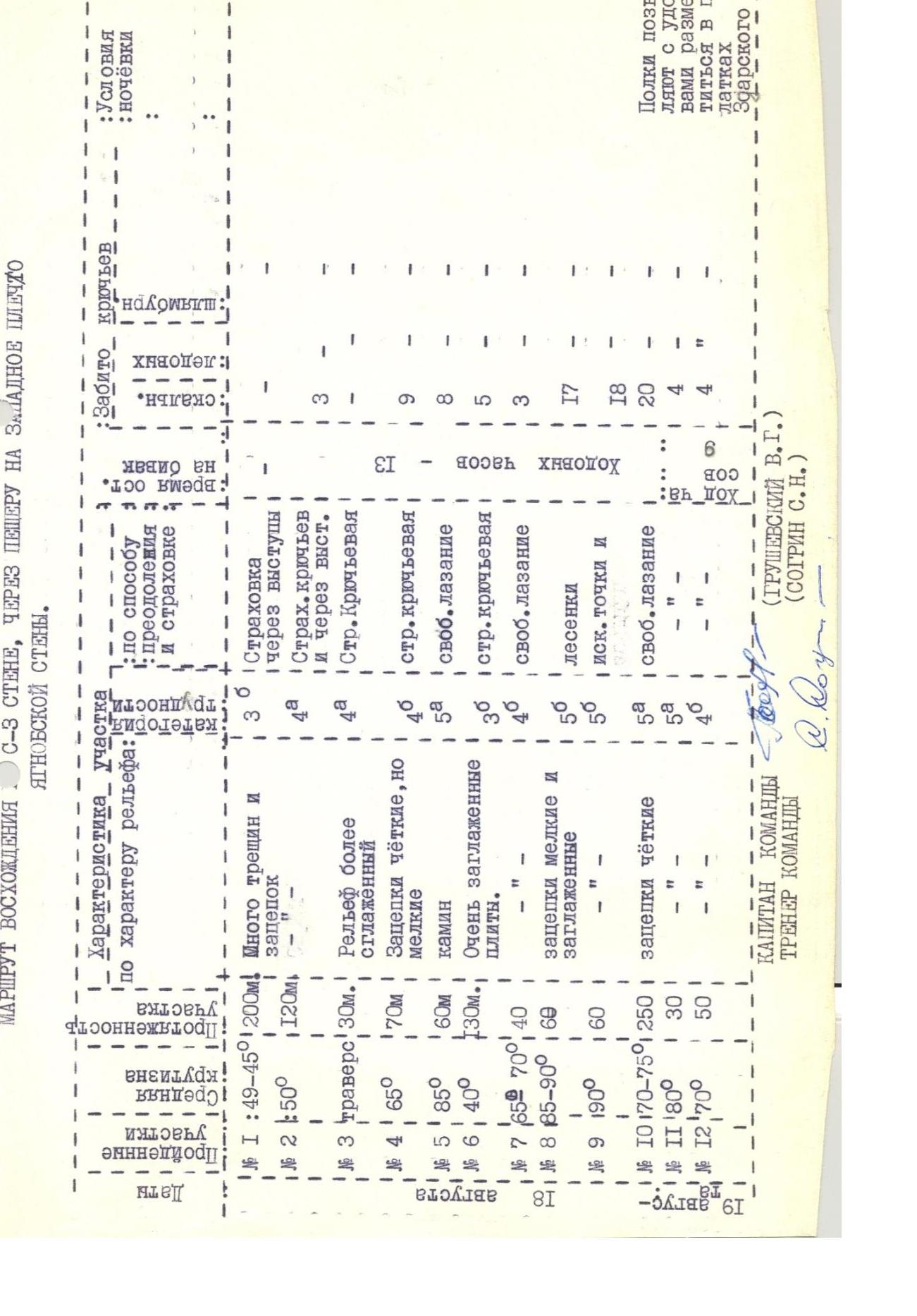
Section #1
The beginning of the route is from a snow tongue upwards, into a couloir formed by the wall and a rock fragment, filled with snow and rocks. The approach is via a zero pitch to the "finger" and circumventing it on the right via simple rocks. Further along rocks of medium difficulty, we reach the main shelf. Protection is via protrusions. The length of the section is 200 m. The overall steepness is 45°–50°.
Section #2
From the shelf, via uncomplicated rocks, we reach beneath a wall with a steepness of 60° and smoothed relief, 60 m long. Protection is via protrusions, sometimes with pitons. The total length of the 2nd section is 120 m. 3 rock pitons were hammered. We reach a narrow, inclined shelf.
Section #3
Along the inclined, sometimes discontinuous shelf, we traverse to the right for 30 m. Protection is via pitons. 3 rock pitons were hammered.
Section #4
Upwards along the light-grey wall, 30 m of complex climbing. Steepness is 65°. Then, via rocks of medium difficulty, we move to the right and upwards beneath the next 60 m wall. Protection is via pitons. The total length of the section is 70 m. 9 rock pitons were hammered.
Section #5
Upwards along the wall. Ten meters of complex climbing lead to a vertical chimney, 15 m long. Further movement is upwards along difficult rocks. Protection is via pitons. The length of the section is 60 m. 8 rock pitons were hammered.
Section #6
Movement to the right and upwards beneath reddish rocks along a large inclined shelf, representing a smoothed slab. Steepness increases from 35° to 50°. Protection is via pitons. Length is 130 m. 5 rock pitons were hammered.
We reach a large black niche.
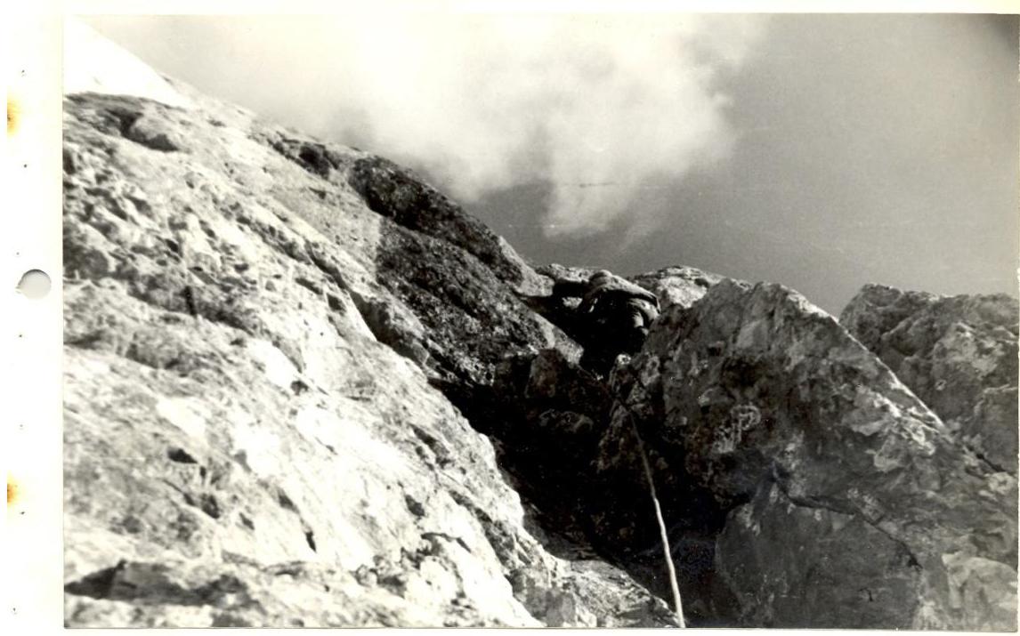
Section #7
From the niche, to the left and upwards along a wall with a steepness of 65°–70° — we reach the cave. The wall represents a monolithic slab with narrow cracks. Pitons enter poorly. Length is 40 m. 3 rock pitons were hammered. In the cave, there is a cairn.
Section #8
The beginning of the key section. From the cave, a small traverse to the left. Further upwards along cracks, and following it, we move to the right and upwards. The crack is clear and continuous, but in many places, it is clogged. Steepness is 85°–39°. Holds are small and smoothed. Climbing is difficult. Often, artificial holds and ladders are used. Protection is via pitons. Backpacks are pulled up.
The length of the section is 60 m. 17 rock pitons were hammered.
Section #9
We continue movement upwards and to the right until we reach a completely monolithic grey wall without cracks or holds. At this point, we begin a traverse to the right with a small gain in height. Climbing is very difficult; artificial holds and ladders are used. The traverse leads to a large niche in reddish rocks. From the niche, straight upwards through an overhang, and further along the wall — we reach a shelf. This part of the section is passed via ladders. Due to the difficulty of the section for passing via perils, it is advisable to pass along the shelf to the left and lower a free rope vertically. The length of the section is 60 m. Steepness is 90°. 18 rock pitons were hammered.
Section #10
The section represents an alternation of short walls (15–20 m) with short shelves or small platforms. No noticeable sections or landmarks are present. Choosing the most logical path, we reach the ridge not far from the peak, before a reddish wall, 30 m high. In the middle of this section, due to the onset of darkness, we made a night halt. The platforms do not allow for pitching a tent, but sleeping in Zarsky tents is very comfortable. The overall steepness of the section is 70–75°, with frequent vertical walls, 15–20 m high. Protection is via pitons. 20 rock pitons were hammered.
Section #11
Upwards along the wall, climbing is complex. Holds are very small but not smoothed. Protection is via pitons. The length of the section is 30 m.
List:
- 4 rock pitons were hammered.
Section #12
Along the ridge, via rocks of 4–6 category difficulty, we reach the peak. Protection is via pitons. The length of the section is 50 m.
List:
- 4 rock pitons were hammered.
From the peak, steep talus slopes lead to the south. Without losing height, we need to traverse to the left to a rock buttress. After crossing it, we begin our descent downwards and to the left, descending into the second main couloir. Then, downwards along the trail, which runs along the stream, to the Margib village.
Section 45 BUIKHO from stone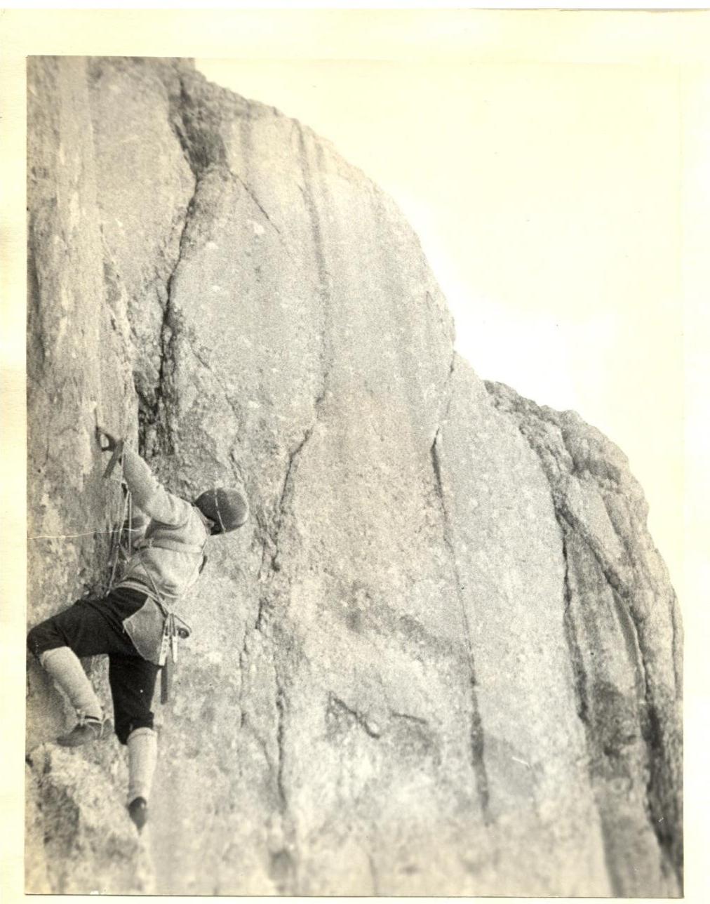
Pure K ∼ 8