- Climbing category: technical
- Climbing area: Yagnob wall
- Peak, its height and climbing route: 1st West Zamin-Karora, 4303 m, via the center of the left part of the NW wall.
- Proposed category of difficulty: 6B.
- Route characteristics: height difference — 1353 m; route length — 1670 m; average steepness — 87°; section lengths: 3rd category of difficulty — 200 m, 2nd category of difficulty — 10 m, 4th category of difficulty — 250 m, 5th category of difficulty — 640 m, 6th category of difficulty — 570 m.
- Number of pitons: for belaying: rock — 201 pcs; chocks — 83 pcs; bolt pitons — 2 pcs. Used for creating ITO: rock — 22 pcs; chocks — 32 pcs; bolt pitons — 7 pcs.
- Number of climbing hours: 49 h 45 min.
- Number of bivouacs and their characteristics: first in a cave without water; the rest on ledges with snow and ice; all comfortable (four) lying down.
- Full name of the team leader, participants, their qualification: SAMODED Alexey Anatolyevich, Master of Sports of the USSR — captain; ZASYPKIN Vyacheslav Vladimirovich, Master of Sports of the USSR — deputy captain; VOLYNSKY Vitaly Alexandrovich, Master of Sports of the USSR — participant; GRISHCHENKO Viktor Ivanovich, Master of Sports of the USSR — participant; VASILENKO Gennady Ivanovich, Candidate for Master of Sports — participant; GOLUBENKO Mikhail Nikolayevich, Candidate for Master of Sports — participant.
- Team coach: KENEITSKY Leopold Vsevolodovich, Master of Sports of the USSR, senior instructor.
- Date of departure on the route and ascent: July 28, 1979 — departure date; August 1, 1979 — return date. 13:00 on August 5, 1979.
Captain A. SAMODED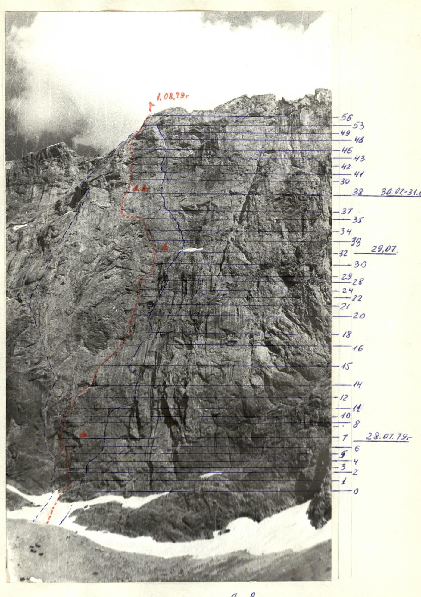
Table of main route characteristics
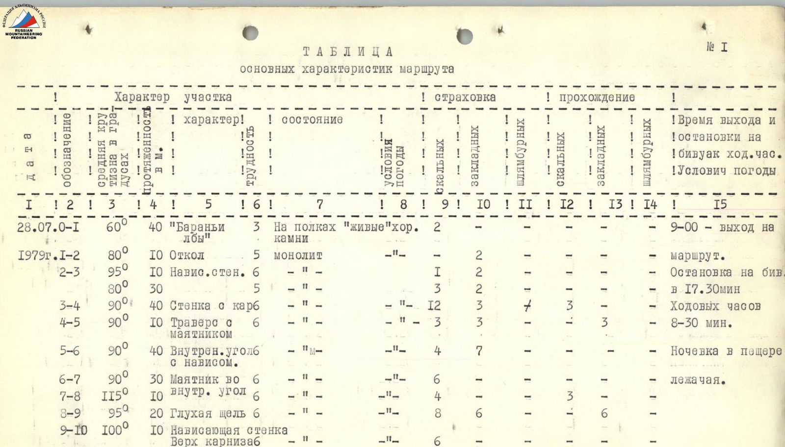

| № | Date | Section | Average steepness of section | Length, m | Character | Difficulty | Condition | Weather conditions | Belay (rock) | Belay (chocks) | Belay (bolts) | Passage (rock) | Passage (chocks) | Passage (bolts) | Exit and bivouac time, climbing hours | Weather conditions |
|---|---|---|---|---|---|---|---|---|---|---|---|---|---|---|---|---|
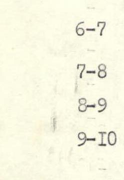
| I | 28.07.79 | R0–R1 | 60° | 40 | «Sheep's foreheads» | 3 | On ledges «live» stones | good | 2 | – | – | – | – | – | 9:00 — exit on route. | |
| 1979 | R1–R2 | 80° | 10 | Chip | 5 | monolith | — | – | 2 | – | – | – | – | Bivouac stop at 17:30. | ||
| R2–R3 | 95° | 10 | Overhanging wall | 6 | — | — | I | 2 | – | – | – | – | Climbing hours 8:30. | |||
| 80° | 30 | — | 5 | — | — | 3 | 2 | – | – | – | – | Overnight in a cave. | ||||
| R3–R4 | 90° | 40 | Wall with a cornice | — | — | — | 12 | 3 | 1 | 3 | – | – | Lying down. | |||
| R4–R5 | 90° | 10 | Traverse with pendulum | 6 | — | — | — | 3 | 3 | – | 3 | – | – | |||
| R5–R6 | 90° | 40 | Inner corner with overhang | — | — | — | 4 | 7 | – | – | – | – | ||||
| R6–R7 | 90° | 30 | Pendulum | 6 | — | — | — | 6 | – | – | – | – | – | |||
| R7–R8 | 115° | 10 | Inner corner | 6 | — | — | — | 4 | – | – | 3 | – | – | |||
| R8–R9 | 95° | 20 | Blind crack | 6 | — | — | — | 8 | 6 | – | 1 | – | 6 | |||
| R9–R10 | 100° | 10 | Overhanging wall Above the cornice | 6 | — | — | — | 6 | 1 | – | – | – | – | |||
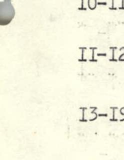
| II | 29.07 | R10–R11 | 87° | 20 | Crack, overhanging corner, shelf | 6 | monolith | good | – | 7 | – | – | – | – | Exit time: 7:30. | |
| R11–R12 | 90° | 40 | Inner corner, shelf | 6 | — | — | – | 3 | 5 | – | – | – | – | Stop at 21:45. | ||
| 1979 | R12–R13 | 90° | 40 | Overhanging inner corner | 5 | — | — | – | 4 | 3 | – | – | – | – | Climbing hours 14:15. | |
| R13–R14 | 45° | 10 | Shelf | 2 | — | — | – | 1 | – | – | – | – | – | |||
| R14–R15 | 90° | 30 | Blind crack | 6 | — | — | – | 5 | – | – | – | – | – | |||
| R15–R16 | 80° | 40 | Oblique crack | 5 | — | — | – | 9 | – | – | – | – | – | |||
| R16–R17 | 85° | 40 | Wall | 4 | — | — | – | 4 | – | – | – | – | – | |||
| R17–R18 | 70° | 40 | Broken wall | 4 | Crumbly rocks | — | – | 5 | – | – | – | – | – | |||
| R18–R19 | 90° | 15 | Inner corner, shelf | 6 | monolith | — | – | 1 | 1 | – | – | 1 | – | |||
| R19–R20 | 90° | 25 | Tile, inner corner | 6 | — | — | – | 2 | 5 | – | – | 1 | – | |||
| R20–R21 | 70° | 40 | Unstable wall | 4 | Crumbly | — | – | 2 | 2 | – | – | – | – | |||
| R21–R22 | 80° | 10 | Wall | 5 | monolith | — | – | 2 | – | – | – | – | – | |||
| R22–R23 | 80° | 30 | Traverse | 5 | — | — | – | 2 | – | – | – | – | – | |||
| R23–R24 | 80° | 30 | Wall | 5 | — | — | – | 3 | 1 | – | – | – | – | |||
| R24–R25 | 70° | 10 | Traverse | 5 | — | — | – | 1 | – | – | – | – | – | |||
| III | 29.07 | R25–R26 | 85° | 20 | Wall | 6 | monolith | good | 3 | 2 | – | – | – | – | – | |
| R26–R27 | 85° | 10 | Traverse under cornice into corner | 6 | — | — | I | I | – | – | 1 | – | – | |||
| R27–R28 | 90° | 40 | Wall with inner corner | 6 | — | — | – | 3 | 4 | – | 1 | – | – | |||
| R28–R29 | 85° | 30 | Traverse | 5 | — | — | – | 2 | 2 | – | – | – | – | – | ||
| R29–R30 | 95° | 10 | Cornice | 6 | — | — | – | 2 | – | – | – | – | – | – | ||
| R30–R31 | 90° | 10 | Wall | 5 | — | — | – | I | – | – | – | – | – | – | ||
| R31–R32 | 70° | 30 | Wall with «live» stones | 3 | Crumbly | — | 3 | 2 | – | – | – | – | – | |||
| 30.07 | R32–R33 | 60° | 40 | Cascade of ledges | 3 | «Live» stones | — | 4 | – | – | – | – | – | Exit time: 9:00. | ||
| R33–R34 | 90° | 60 | Wall of overhanging inner corners. | 5 | monolith | — | 5 | 3 | – | – | – | – | Stop for bivouac at 17:00. | |||
| R34–R35 | 95° | 40 | Overhanging wall to the left of the inner corner with «live stones» | 6 | monolith | — | 4 | 3 | – | – | – | – | Climbing hours 8:00. | |||
| R35–R36 | 90° | 40 | Traverse along the wall | 5 | — | — | – | 4 | 2 | – | – | – | – | – | ||
| R36–R37 | 80° | 60 | Traverse along the shelf | 3 | — | — | – | 6 | 2 | – | – | – | – | – | ||
| R37–R38 | 80° | 100 | Inner corners with overhanging sections | 5 | — | — | – | 8 | 6 | – | 2 | – | – | |||
| R38–R39 | 80° | 60 | Inner corners with cornice | — | — | — | – | 6 | 2 | – | 1 | 1 | – | |||
| R39–R40 | 95° | 10 | Overhanging wall | 6 | — | — | – | 6 | – | – | – | – | – | – | ||
| R40–R41 | 90° | 30 | Wall with few holds | 6 | — | — | – | II | – | – | – | – | – | |||
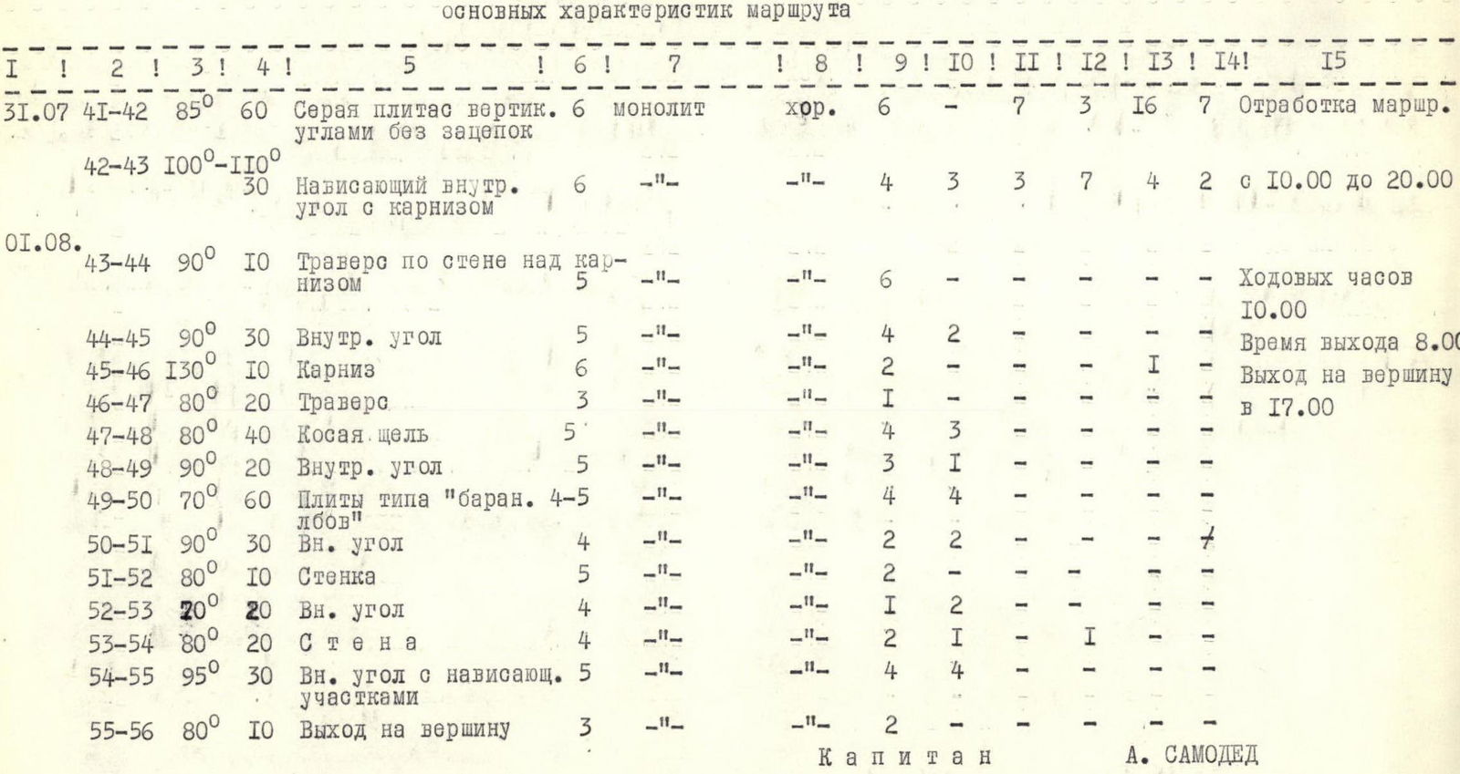
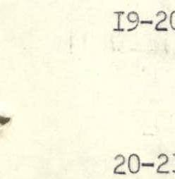
| IV | 31.07 | R41–R42 | 85° | 60 | Gray slab with vertical corners without holds | 6 | monolith | good | 6 | – | 7 | 3 | 16 | 7 | Working out the route. | |
| R42–R43 | 100°–110° | 30 | Overhanging inner corner with cornice | 6 | — | — | – | 4 | 3 | 3 | 7 | 4 | 2 | From 10:00 to 20:00. | ||
| 01.08. | R43–R44 | 90° | 10 | Traverse along the wall above the cornice | 5 | — | — | – | 6 | – | – | – | – | – | Climbing hours 10:00. | |
| R44–R45 | 90° | 30 | Inner corner | 5 | — | — | – | 4 | 2 | – | – | – | – | Exit time 8:00. | ||
| R45–R46 | 130° | 10 | Cornice | 6 | — | — | – | 2 | – | – | – | – | 1 | Reach the summit at 17:00. | ||
| R46–R47 | 80° | 20 | Traverse | 3 | — | — | – | 1 | – | – | – | – | – | |||
| R47–R48 | 80° | 40 | Oblique crack | 5 | — | — | – | 4 | 3 | – | – | – | – | |||
| R48–R49 | 90° | 20 | Inner corner | 5 | — | — | – | 3 | 1 | – | – | – | – | |||
| R49–R50 | 70° | 60 | Slabs like «sheep's foreheads» | 4–5 | — | — | – | 4 | 4 | – | – | – | – | |||
| R50–R51 | 90° | 30 | Inner corner | 4 | — | — | – | 2 | 2 | – | – | – | – | |||
| R51–R52 | 80° | 10 | Wall | 5 | — | — | – | 2 | – | – | – | – | – | |||
| R52–R53 | 20° | 20 | Inner corner | 4 | — | — | – | 1 | 2 | – | – | – | – | |||
| R53–R54 | 80° | 20 | Wall | 4 | — | — | – | 2 | – | – | – | 1 | – | |||
| R54–R55 | 95° | 30 | Inner corner with overhanging sections | 5 | — | — | – | 4 | 4 | – | – | – | – | |||
| R55–R56 | 80° | 10 | Exit to the summit | 3 | — | — | – | 2 | – | – | – | – | – |

Explanation for the table


 ![img-74.jpeg]({"width":248,"height":