Ascent Report from the Hissar Ridge spurs
to the summit of Zamin Karor I Western 4303 m via the central part of the North-West wall, 6B (Shramko G. route), by the Kiev regional council team of the “Burevestnik” sports society:
| Participant | Role | Rank |
|---|---|---|
| Savchuk Volad. | team lead | CMS |
| Verba Aleksan | participant | — |
| Kuzmuk V. | — | — |
| Yakovlev V. | — | — |
| Azaryev Igore | — | — |
| Makovei S. | — | — |
Kiev — 1975
Geographical Description of the Route
The Zamin Karor peak (Yaghnob) is located in the northern spurs of the Hissar Ridge, east of the Anzob Pass, and is connected to it by a ridge with the Khosilot peak.
The Zamin Karor massif stretches in a latitudinal direction for 8 km. The highest point is Eastern Zamin Karor, 4767 m.
The eastern part of the wall from the north has significant glaciation. The western part of the massif is purely rocky. The entire northern side of the wall has a significant steepness. The southern slopes are gentle. In the upper part - slabs and glacially scoured rocks, in the lower part - scree. The weather in the area is typical for the Fann Mountains - hot, dry summer.
The base camp is located on a green moraine above the Murhob village, a 4-hour walk from the motor road.
Tactical Plan
At the Varzob camp, the group conducted joint training sessions and climbing exercises in the Igizak gorge.
Materials on ascents in the Yaghnob area were studied. Consultations were obtained from the first ascenders of the route and the head of the KSP of Tajikistan.
Upon arriving in the Yaghnob area, the group made a full ascent to the Western shoulder of Zamin Karor via a 5A category route, as well as several reconnaissance trips.
Equipment was prepared and tested. The technique and tactics of passing the route, organizing hanging camps, and hauling loads were jointly developed and practiced.
On the route, it was planned to vary the tactics of advancement depending on the weight of the loads. In this sense, the ascent can be divided into three stages. The first stage (full load, lower part of the wall). A pair processes the further route, three participants haul load sacks, one participant removes pitons. The second stage (middle part of the wall, some ropes are dropped, water is not hauled, fewer supplies). A pair processes the route, shuttle hauling of loads. The third stage (upper part of the wall, minimal loads packed in backpacks). The group proceeds almost without hauling loads, using a system with two extra ropes.
Overall, this plan was adhered to by the group. All complex sections of the route were pre-processed, except for the upper part of the wall with black streaks.
Route Schedule
- August 6 - the lower part of the route was processed up to the first bivouac.
- August 7 - the group started the route in full composition, loads were hauled, they reached the first bivouac, and processed 3 ropes.
- August 8 - the section above the "room" (R10) was passed, some ropes were dropped.
- August 9 - the group reached under the snow shelf, processed the section up to the shelf.
- August 10 - they reached the snow shelf, processed the giant internal corner; bivouac under the chimney.
- August 11 - the giant internal corner was passed.
- August 12 - the wall with black streaks was passed, they reached the ridge, were on the summit at 16:00, descended to the RG in the Pindor gorge.
- August 13 - return to the base camp.
Route Description
From the base camp, a part of the north-western wall of Zamin Karor is visible from the Central Pass to the Western shoulder.
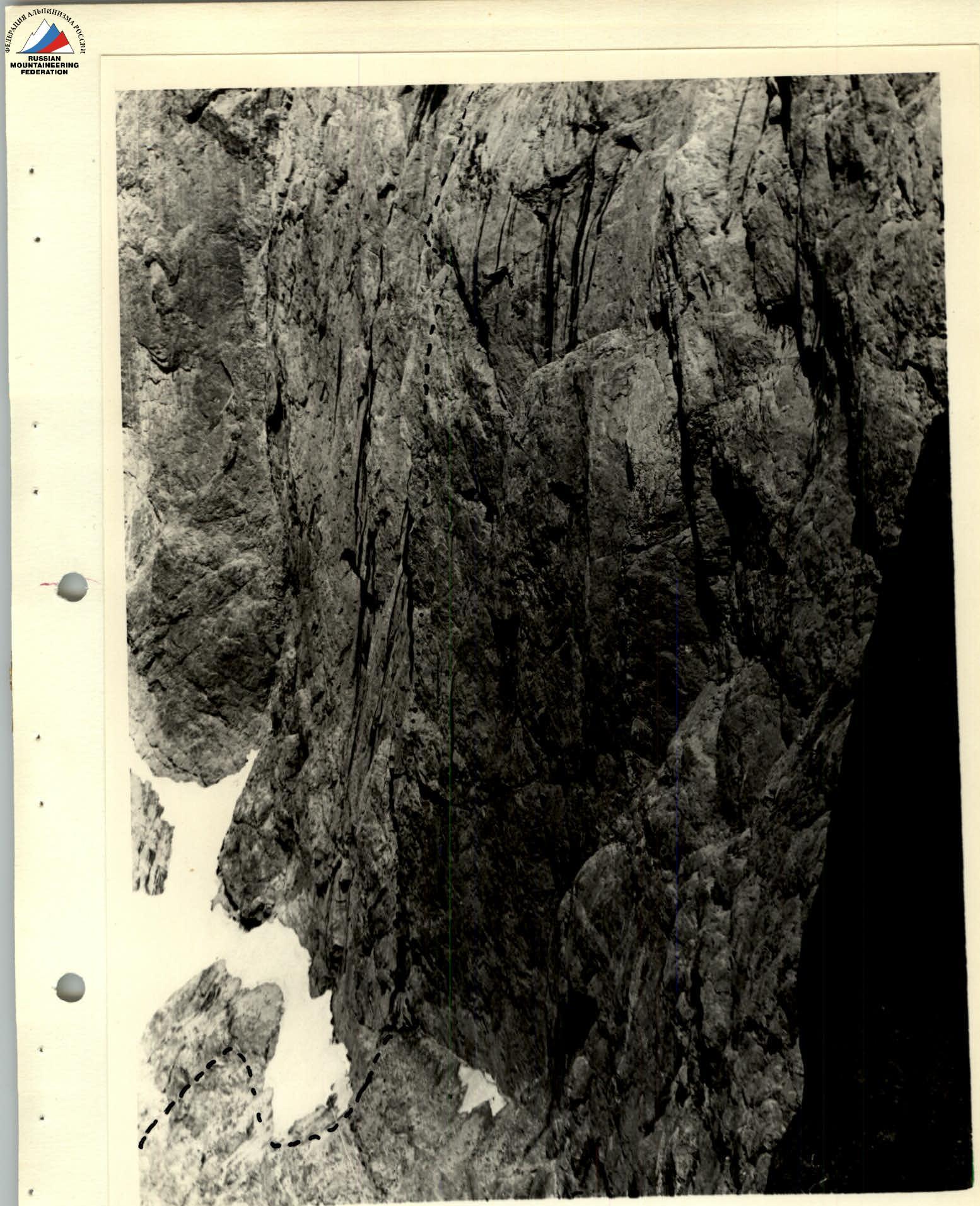
The wall under the 1st Western peak stands out from the massif with a clearly expressed greater steepness. The start of the route is from a green shelf to the right of a vertical fracture, above the glacially scoured rocks. The approach from the base camp is via scree and destroyed glacially scoured rocks with loose stones (R1). After 14:00 - rockfall hazard.
From the green shelf, left to a crack on the wall mirror between the fracture and the green shelf. Along the crack to an internal corner with a cornice. Along a wet, weakly expressed shelf left to a chimney, between the wall and the fracture to a cork (R2).
From the chimney, right along the wall mirror to two thin horizontal cracks and further up the chimney to a cornice (R3). 5 pitons were hammered by Shramko's group.
Through the cornice, along an overhanging crack left upwards to a narrow shelf and a crack leading to an overhanging chimney (between the second fracture and the wall) (R4).
In the widening part of the chimney under the peak of the fracture - bivouac. Pitons were hammered for hammocks, a control cairn. From the bivouac, along a crack - exit to the ridge of the fracture and to the right of it along slabs to the peak of the fracture (R5).
Along the peak of the fracture, left to overhanging glacially scoured rocks, traverse left to a not clearly expressed groove (R6).
Up the groove 50 m to a smooth slab (R7). The smooth slab (R8) leads to a shelf of a huge "room" with overhanging walls.
At the right wall, along overhanging, destroyed feathers to a short ridge above the "room" (R9). Bivouac.
Further along slabs under a cornice (R10). The cornice is passed with ladders, and after it begins a wall with a small number of holds. The wall is passed left along a corner, and then right to an inclined shelf.
From the shelf, left upwards (R11). From a small shelf along an internal corner - exit to inclined slabs (R12), ending with an overhanging wall (R13). The wall is bypassed on the left and ends in a funnel-shaped chimney (R14). The chimney is passed on the right side, then on the slings left to a narrow inclined shelf, along which - exit to the third bivouac. Pitons for hammocks in 3 tiers (R15).
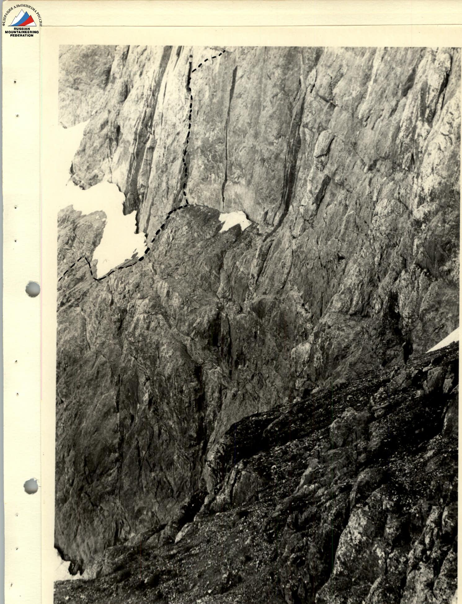
From the shelf, left upwards along wet rocks to a wet chimney with loose rocks. Further along slabs to glacially scoured rocks and along them to a wide snow shelf.
Along the shelf upwards to a chimney leading to an interrupted crack, right upwards in the direction of a giant internal corner overhanging the shelf (R16). Control cairn, bivouac.
Along the chimney and further along a crack to a thin fracture (R17).
From the peak of the fracture:
- the first in the group - traverse right to the internal corner (15 m), then along the opposite smooth wall to destroyed rocks on the edge of the internal corner (R18);
- the rest of the group - down the crack to the internal corner (20 m) and along the rope to destroyed rocks.
Further along destroyed rocks right to a snowpatch and along an osypnaya shelf to an overhanging wall (R19). Control cairn.
The wall is passed head-on (R20).
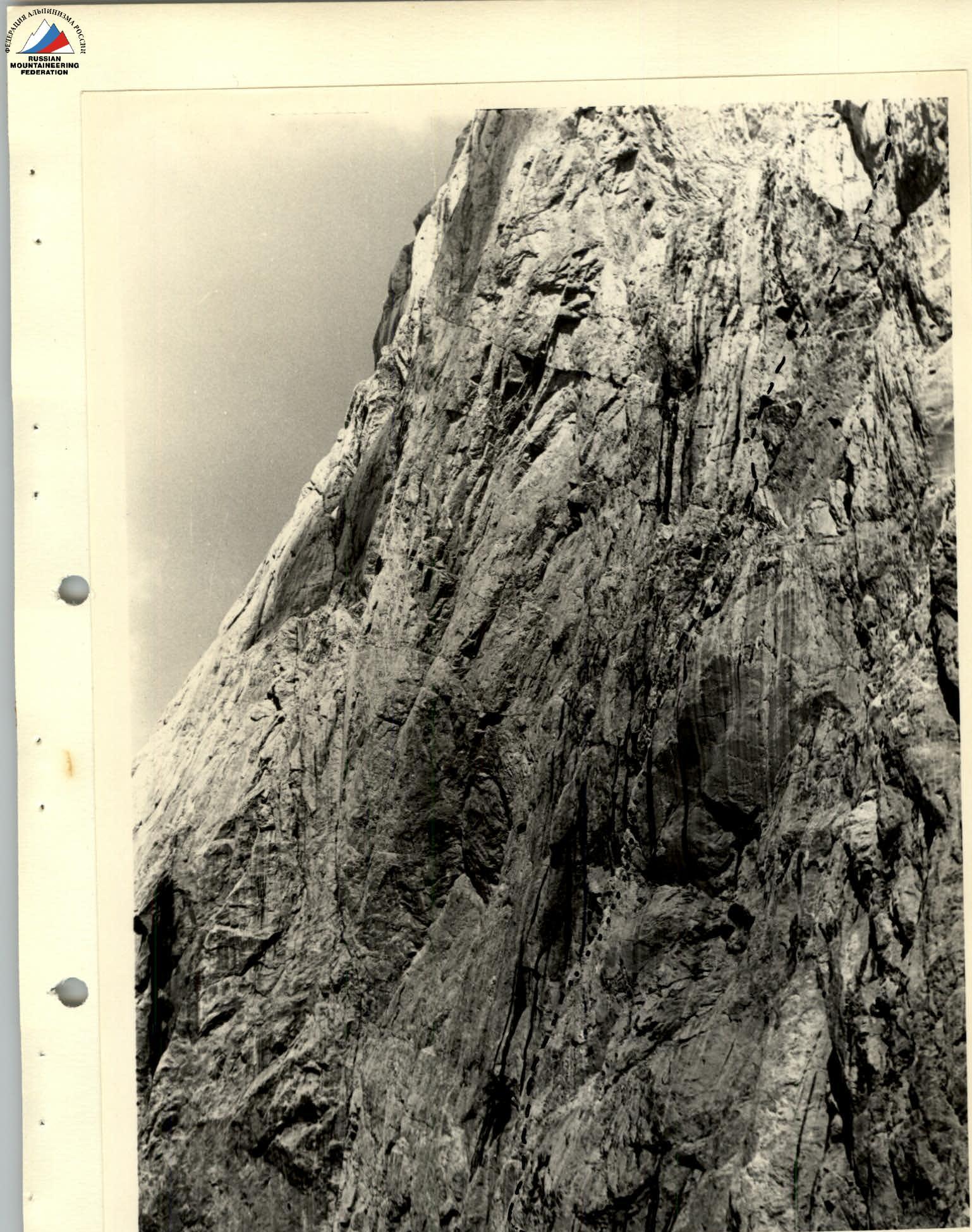
Further along smooth slabs with a very small number of cracks and holds to a wall with black streaks (R21). On this wall - a wet overhanging chimney. Along the left side of the chimney through a cornice to a ledge (R22).
From the ledge - traverse left along a smooth wall (pitons) to the throat of a chimney and along the chimney with water to an osypnaya shelf (R23). Wedges, ladders. Along the shelf left to destroyed rocks (R24). On the destroyed rocks, right upwards in the direction of the ridge (R25).
Along feathers with loose rocks to a couloir leading to the ridge. Feathers overhang (R27). To the summit - along a simple ridge.
Descent along slabs to RG in the Pindor gorge.
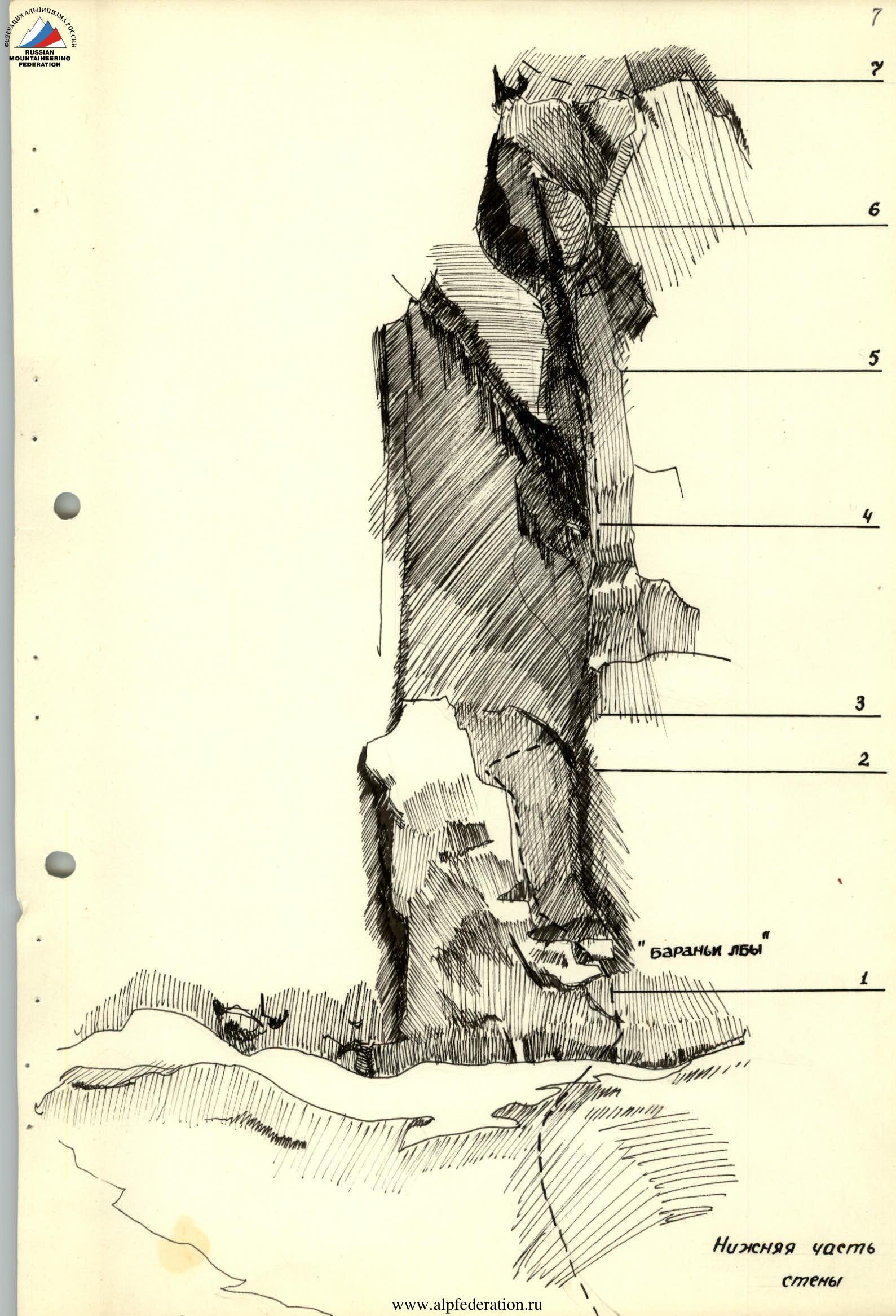
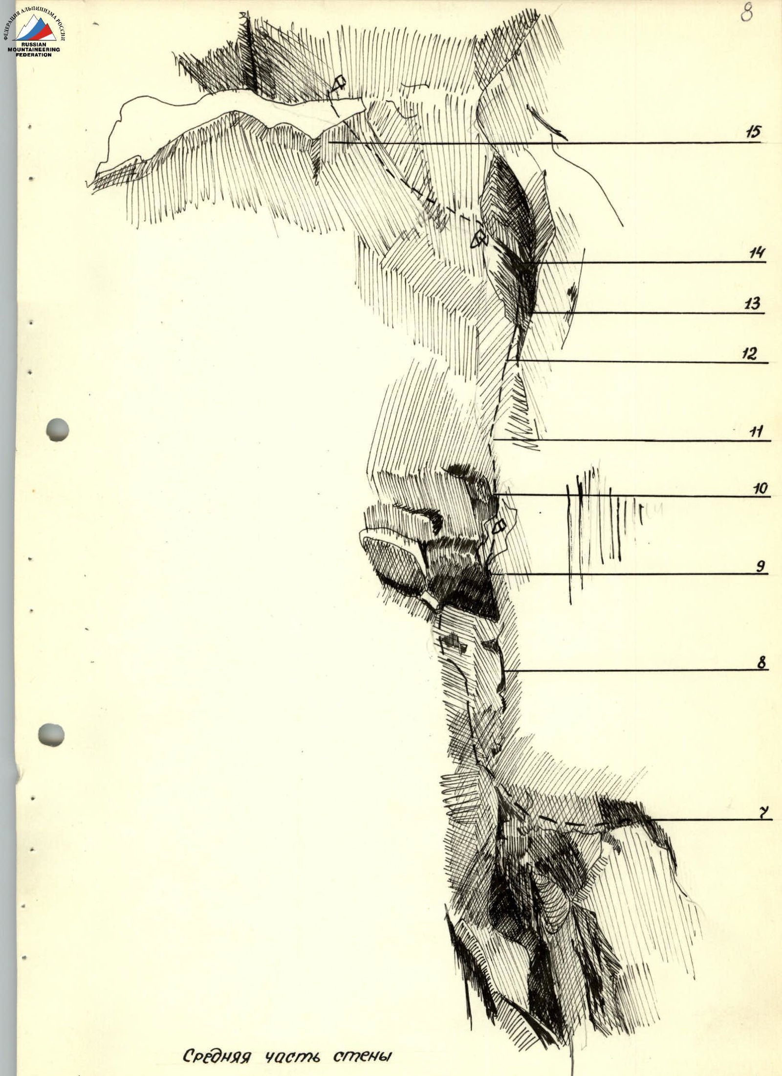
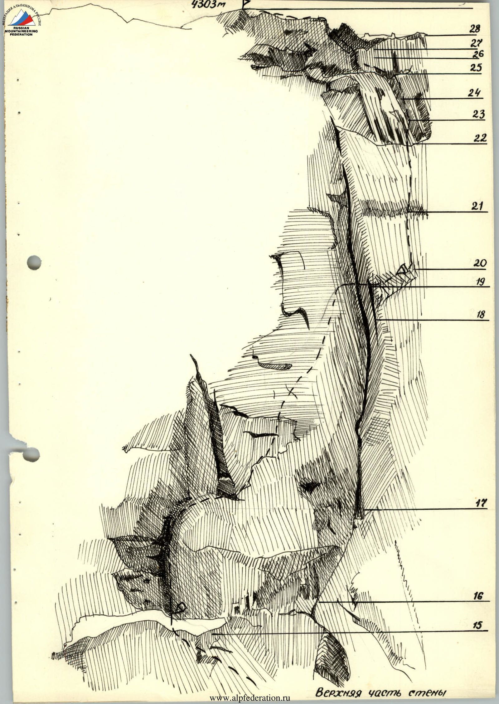
Table of Main Characteristics of the Ascent Route
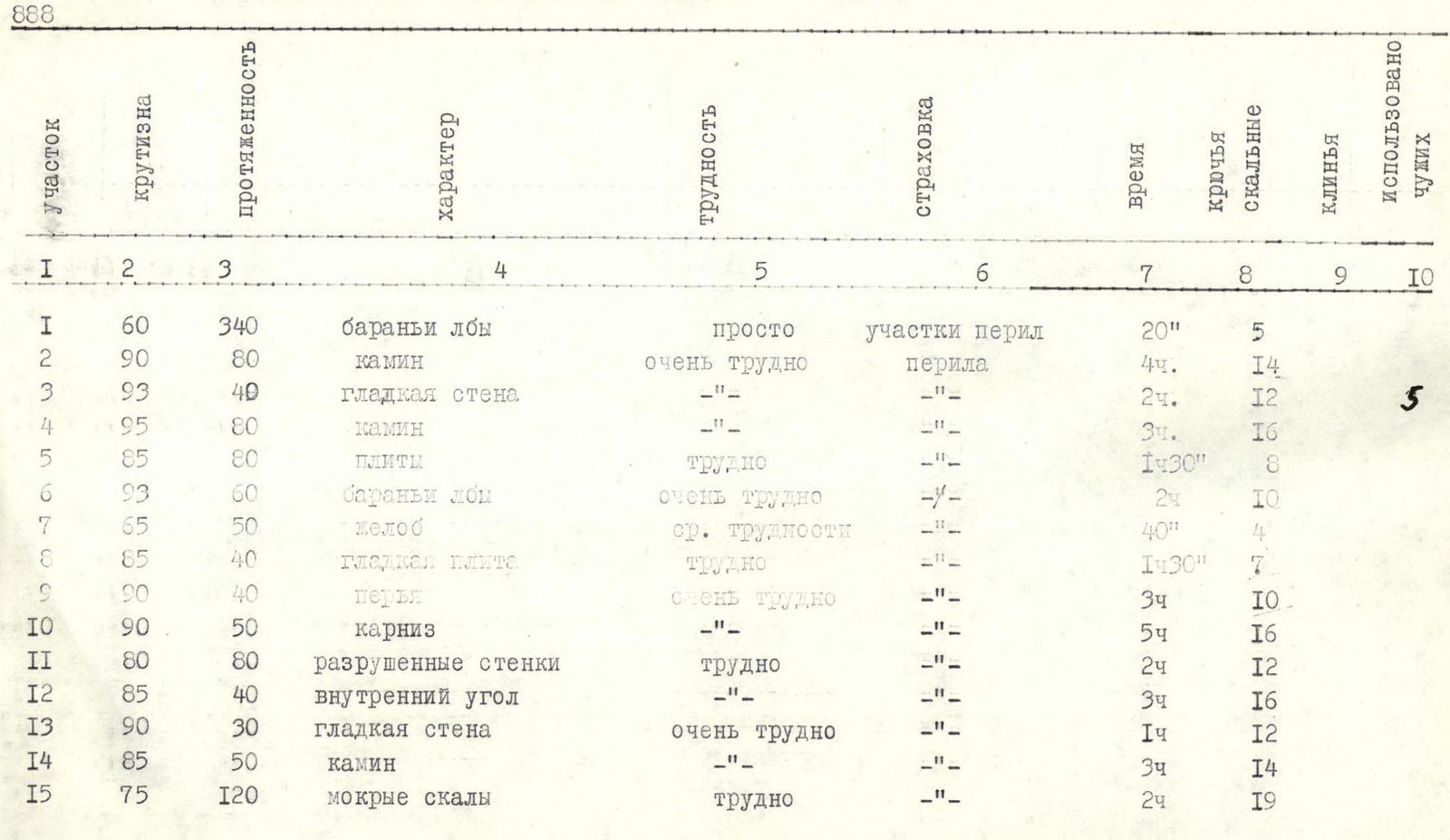
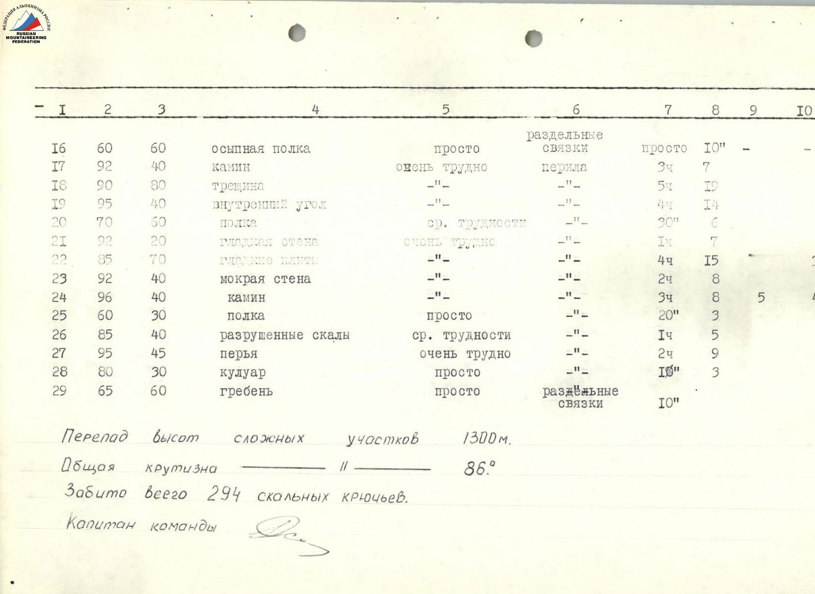
| Section | Steepness | Length | Character | Difficulty | Protection | Time | Rock Pitons | Wedges | Used Others' |
|---|---|---|---|---|---|---|---|---|---|
| R1 | 60 | 340 | glacially scoured rocks | easy | sections of belay | 20 min | 5 | ||
| R2 | 90 | 80 | chimney | very difficult | belay | 4 ч | 14 | ||
| R3 | 93 | 40 | smooth wall | — | — | 2 ч | 12 | ||
| R4 | 95 | 80 | chimney | — | — | 3 ч | 16 | ||
| R5 | 85 | 80 | slabs | difficult | — | 1 ч 30 мин | 8 | ||
| R6 | 93 | 60 | glacially scoured rocks | very difficult | — | 2 ч | 10 | ||
| R7 | 65 | 50 | groove | medium difficulty | — | 40 мин | 4 | ||
| R8 | 85 | 40 | smooth slab | difficult | — | 1 ч 30 мин | 7 | ||
| R9 | 90 | 40 | feathers | very difficult | — | 3 ч | 10 | ||
| R10 | 90 | 50 | cornice | — | — | 5 ч | 16 | ||
| R11 | 80 | 80 | destroyed walls | difficult | — | 2 ч | 12 | ||
| R12 | 85 | 40 | internal corner | — | — | 3 ч | 16 | ||
| R13 | 90 | 30 | smooth wall | very difficult | — | 1 ч | 12 | ||
| R14 | 85 | 50 | chimney | — | — | 3 ч | 14 | ||
| R15 | 75 | 120 | wet rocks | difficult | — | 2 ч | 19 | ||
| R16 | 60 | 60 | osypnaya shelf | easy | separate rope | 10 мин | — | ||
| R17 | 92 | 40 | chimney | very difficult | belay | 3 ч | 7 | ||
| R18 | 90 | 80 | crack | — | — | 5 ч | 19 | ||
| R19 | 95 | 40 | internal corner | — | — | 4 ч | 14 | ||
| R20 | 70 | 60 | shelf | medium difficulty | — | 30 мин | 6 | ||
| R21 | 92 | 20 | smooth wall | very difficult | — | 1 ч | 7 | ||
| R22 | 85 | 70 | smooth slabs | — | — | 4 ч | 15 | 3 | |
| R23 | 92 | 40 | wet wall | — | — | 2 ч | 8 | ||
| R24 | 96 | 40 | chimney | — | — | 3 ч | 8 | 5 | 4 |
| R25 | 60 | 30 | shelf | easy | — | 20 мин | 3 | ||
| R26 | 85 | 40 | destroyed rocks | medium difficulty | — | 1 ч | 5 | ||
| R27 | 95 | 45 | feathers | very difficult | — | 2 ч | 9 | ||
| R28 | 80 | 30 | couloir | easy | — | 10 мин | 3 | ||
| R29 | 65 | 60 | ridge | easy | separate rope | 10 мин |
Height difference of complex sections: 1300 m.
Overall steepness: 86°.
Total pitons hammered: 294.
Team Captain:
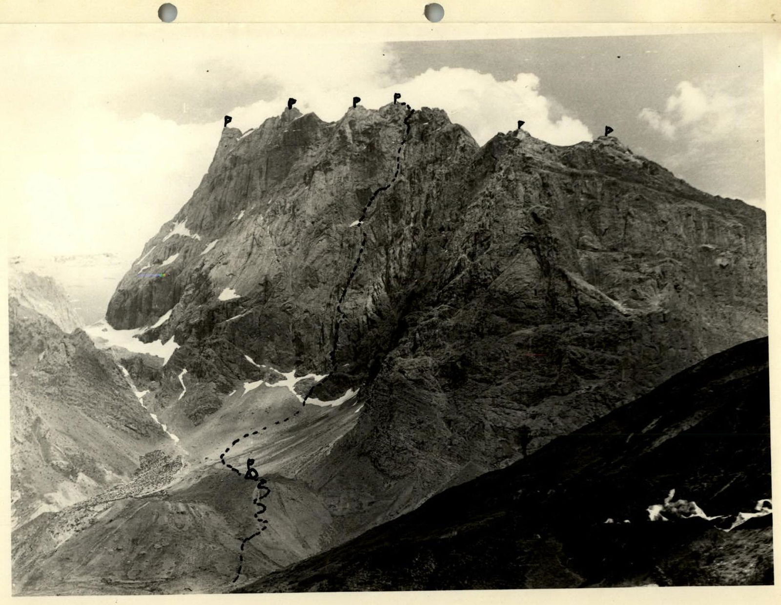
NW wall of Zamin Karor
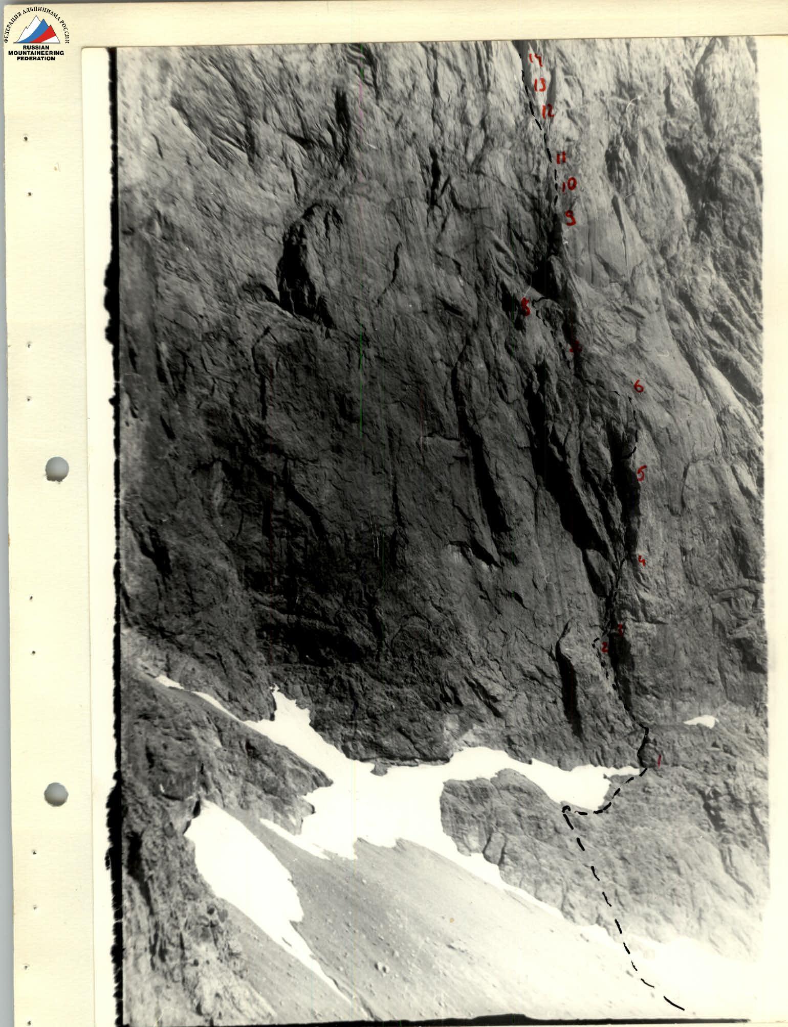
Lower part of the wall
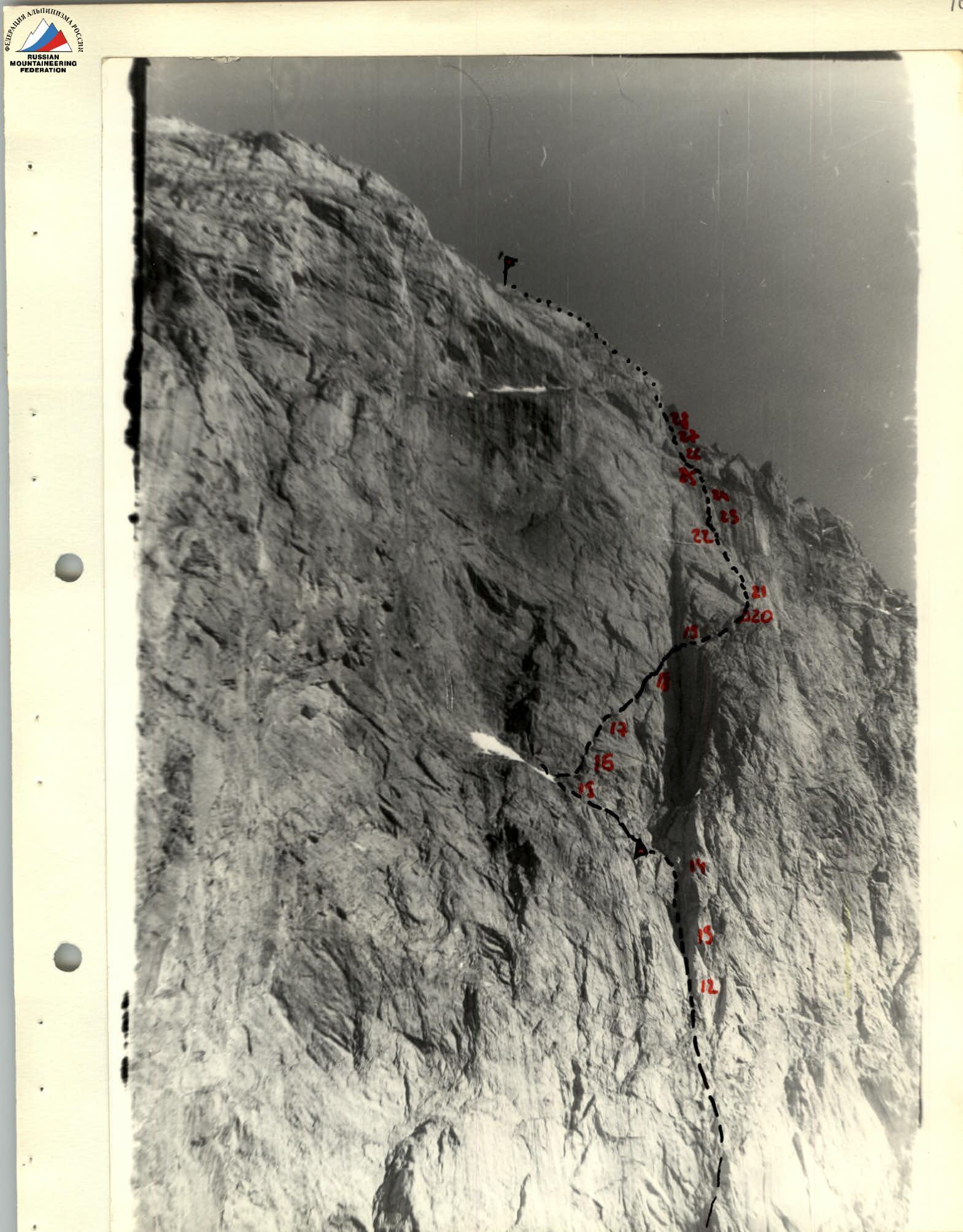
Upper part of the wall
Start of the route
Profile of the lower part of the wall
Profile of the middle part of the wall