Climbing Passport
- Class — technical
- Gissarsky Range
- Western summit of Zamin Karor, height — 4303 m (first ascent)
- Proposed category of difficulty — 6B
- Route characteristics: height difference — 1303 m length of sections: 1030 m average steepness — 85°
- Number of pitons used:
- rock pitons:
- for belaying — 77
- for creating intermediate protection points — 15
- bolt pitons:
- for belaying — 3
- for creating intermediate protection points — 6
- chockstones:
- for belaying — 192
- for creating intermediate protection points — 20
- ice screws:
- for belaying — none
- for creating intermediate protection points — none
- rock pitons:
- Total climbing hours — 48
- Number of bivouacs and their characteristics: 4 bivouacs, including 2 sitting and 2 lying down
- Team composition:
- Sergey Antipin — team captain, CMS
- Sergey Klyukvin — deputy captain, MS
- Sergey Bayakin — team member, CMS
- Valery Bezzubkin — team member, MS
- Team coach: Vitaly Yakovlev, MS
- Departure date — July 29, 1979 Return date — August 2, 1979
Tactics of the Ascent
Based on observations and experience from previous climbs, the following tactics were adopted:
- Preliminary processing of the route according to the "Regulations" was excluded, but subsequent days during the ascent included preliminary processing, which was carried out on July 29, July 30, and August 1.
- The entire route was divided into 5 parts and was to be completed in 5 days, which was achieved.
- Four bivouacs were planned, all of which were satisfactory, safe, and provided sufficient rest for the team members to recover.
- Observations highlighted three challenges on the route: passing the lower cornices "Ushi", navigating the middle section ("ryжая стена" or red wall), and overcoming the upper cornice. The team successfully overcame these challenges.
- The tactical plan involved all team members in key operations during the ascent, including route processing, leading, and hauling rucksacks. This required maximum physical and mental effort and excellent mountaineering technique.
- The team decided not to bring a tent and limited their daily food ration to 500 g per person.
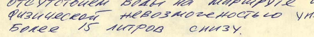
- The drinking water regime was limited by the absence of water on the route and the physical impossibility of carrying more than 15 liters from the bottom.
- The team planned to use new equipment samples, including chockstones and jumar ascenders. Chockstones of three types were used: "stoppers", "hexes", and "eccentrics" (Abalakov's cams). These were particularly useful in areas where it was impossible to hammer in a reliable piton, enabling quick and reliable belay organization. For ascending on a fixed rope, a chest-leg system with two jumar ascenders was used, allowing for quick ascents with a rucksack on steep and hanging sections.
Table of main characteristics of the ascent route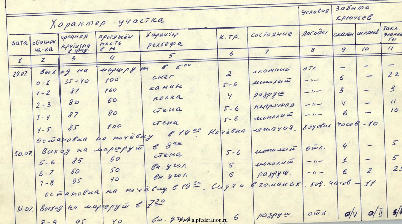
| Date | Section designation | Average steepness in degrees | Length in m | Terrain character | Category of difficulty | Condition | Weather | Rock pitons used | Bolt pitons used | Chockstones used |
|---|---|---|---|---|---|---|---|---|---|---|
| 29.07. | Departure at 6:00 | |||||||||
| R0–R1 | 35–40 | 100 | snow | 2 | dense | excellent | — | — | — | |
| R1–R2 | 87 | 160 | chimney | 5–6 | monolithic | – // – | 6 | — | 22 | |
| R2–R3 | 80 | 60 | ledge | 4 | destroyed | – // – | — | — | 3 | |
| R3–R4 | 87 | 80 | wall | 5–6 | unstable | – // – | 4 | — | 11 | |
| R4–R5 | 85 | 100 | wall | 5–6 | monolithic | – // – | 6 | — | 10 | |
| Bivouac at 19:00. Lying down bivouac. Climbing hours — 10 | ||||||||||
| 30.07. | Departure at 8:00 | |||||||||
| R5–R6 | 85 | 60 | wall | 5–6 | monolithic | excellent | 4 | — | 5 | |
| R6–R7 | 60 | 50 | internal corner | 5 | monolithic | – // – | 1 | — | 5 | |
| R7–R8 | 95 | 40 | internal corner | 6 | destroyed | – // – | 6 | 2 | 25 | |
| Bivouac at 19:30. Sitting and in hammocks. Climbing hours — 11 | ||||||||||
| 31.07. | Departure at 7:20 | |||||||||
| R8–R9 | 95 | 70 | internal corner | 6 | destroyed | excellent | (0/V) | (0/II) | (5/XV) | |
| R9–R10 | 85 | 60 | wall | 5–6 | destroyed | excellent | 4 | — | 6 | |
| R10–R11 | 85 | 70 | chimney | 5–6 | destroyed | – // – | 4 | — | 13 | |
| R11–R12 | 90 | 40 | internal corner | 6 | destroyed | – // – | 5 | 1 | 10 | |
| R12–R13 | 87 | 120 | slabs | 5–6 | monolithic | – // – | 10 | — | 20 | |
| Bivouac at 21:00. In hammocks. Climbing hours — 13 | ||||||||||
| 01.08. | Departure at 7:00 | |||||||||
| R13–R14 | 87 | 200 | slabs | 5–6 | monolithic | excellent | 12 | 1 | 23 | |
| Bivouac at 19:00. Lying down bivouac. Climbing hours — 7 | ||||||||||
| 02.08. | Departure at 7:00 | |||||||||
| R14–R15 | 100 | 70 | cornice | 6 | monolithic | excellent | (4/k) | 1 | (5/V) | |
| R15–R16 | 75 | 250 | slabs | 4–5 | destroyed | excellent | 8 | — | 29 | |
| Reached the summit at 14:00. Climbing hours 7. | ||||||||||
| Total route length — 1440 m. | ||||||||||
| Total climbing hours — 48. | ||||||||||
| Average steepness — 85° |
Brief explanation of the table of main characteristics of the ascent route.


 ![img-94.jpeg]({"width":1372,"height":156,"format":"Jpeg","uri":"https://summitx.info/media/1/l2BnCK↗