Ascent Record
I. Ascent class - technical.
-
Ascent area - Zamin Karor (Yaghnob wall).
-
Peak, its height, ascent route - Zamin Karor II-Western, 4525 m, via N-W wall, qualifying (Lapshik).
-
Proposed difficulty category - 5B.
-
Route characteristics:
elevation gain - 1500 m, average steepness - 55–60°, length of sections with 5–6 difficulty category - 540 m.
- Pitons driven for belay:
rock - 92, ice - 7, bolted - none; for creating artificial holds: rock - 7, ice - 2, bolted - none.
- Total climbing hours - 14 hours.
- Number of bivouacs and their characteristics:
1st bivouac by a stream after descending from the summit. 9. Full names of the leader and participants, their sports qualification:
Slavinsky Pavel Frantsevich, Candidate for Master of Sports, leader; Bovkun Vladimir Romanovich, 1st sports category; Gurov Vladimir Nikolaevich, 1st sports category.
- Team coach - Kensitsky L.V.
II. Date of departure on the route - July 24, 1977, return to base camp - July 25, 1977.
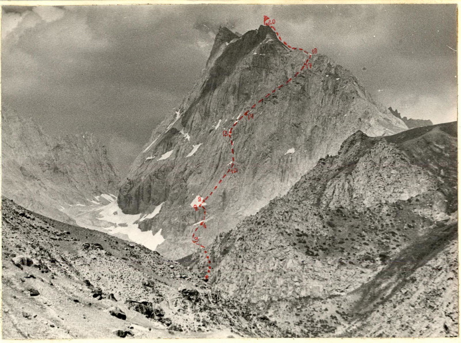
Table I
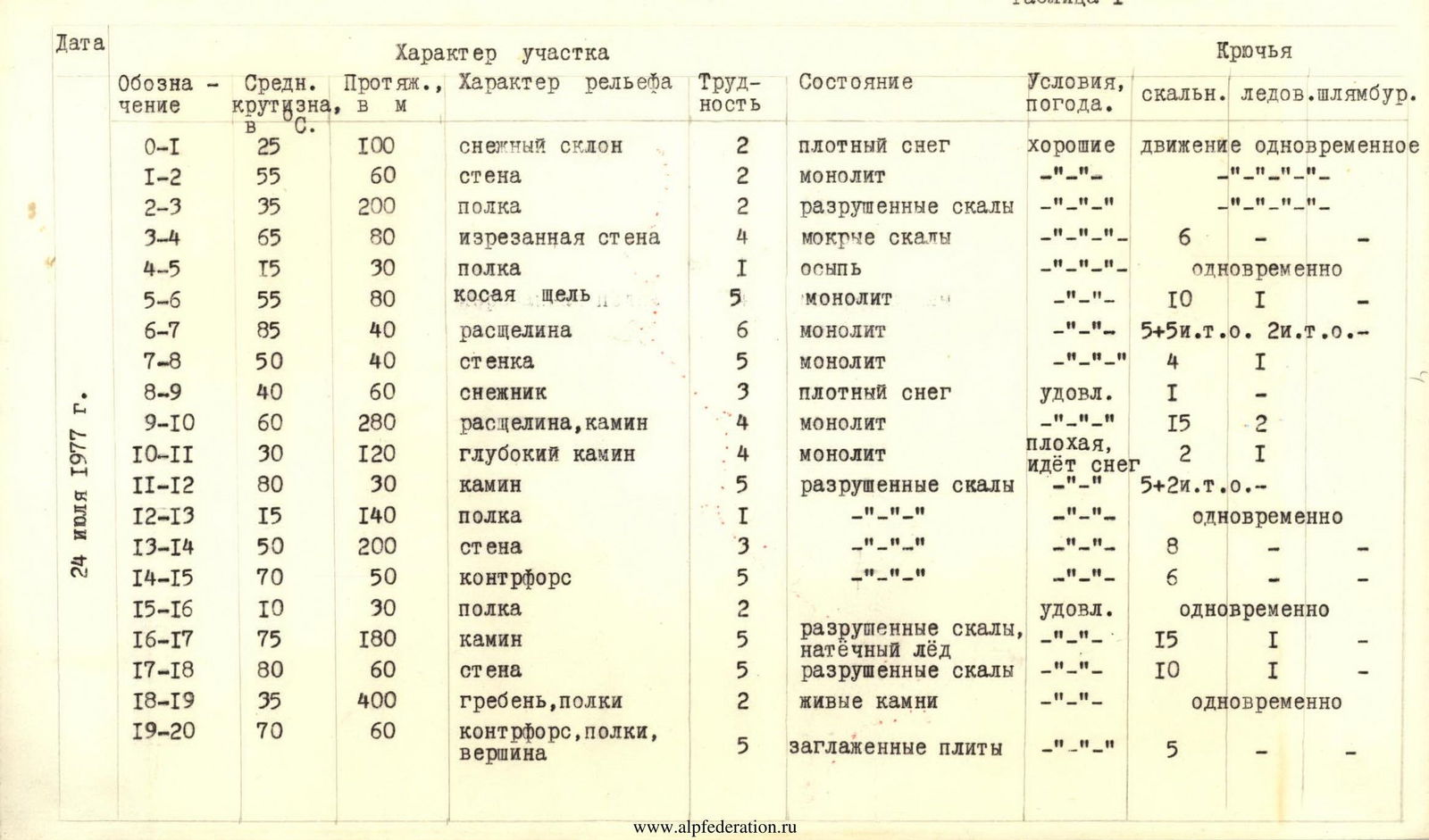
Brief explanations for Table I.
Departure from base camp - July 24, 1977, at 4:00. Ascended via scree to under the Northwest wall of the II Western peak of Zamin Karor.
Section R0–R1. Snowy, gentle slope, 100 m long. Snow is dense. Climbing while connected.
Section R1–R2. Transition from snow to easy rock, ascent towards a broad ledge. Simultaneous movement.
Section R2–R3. Wide ledge, up to 10 m, with snow patches. Ledge direction is left-up. After 200 m, at the end of the ledge - platforms.
Section R3–R4. From the platforms, via a rugged wall (wet rocks, piton belay) reached the second ledge.
Section R4–R5. Along the ledge, 30 m to the right, towards sheer dark-colored walls. Loose rocks on the ledge.
Sections R5–R8. To the right of the dark band, from the flowing water, right-up via an intermittent crack, 80 m, to a narrow ledge. Along the left part of a large wet patch, a sheer crack, 40 m; very difficult climbing, piton belay. Then, via a wall, 40 m - exit to a large snow patch, shaped like an axe. Good platforms for bivouacs here. Weather started to deteriorate, strong wind.
Section R8–R9. Ascent up the snow patch towards a chimney-crack.
Section R9–R10. Via an intermittent chimney-crack (in places, the chimney narrows to several centimeters), movement with piton belay, rocks are smooth. The chimney leads to a sheer wall. I control point.
Section R10–R13. Via a deep chimney, left-up, 120 m, to the next sheer chimney, 30 m, which leads to a broad ledge. At the end of the ledge (140 m): II control point and good bivouac platforms. Bad weather, snowfall.
Sections R13–R16. Above the platforms, walls of the II Western peak overhang. Right-up, via a wall, 180 m, to a weakly defined buttress. Along it, 60 m up, to a ledge going right to a crack-chimney. Snowfall, rocks are wet and slippery.
Sections R16–R18. Via a narrow chimney, 180 m, ascent to the wall of the ridge. Difficult climbing on the wall, piton belay, - and exit to the ridge. Intermittent snowfall.
Sections R18–R20. Platforms on the ridge. The ridge ascends steeply towards the summit. Traverse along the southern slopes of the ridge to a weakly defined buttress, ascent to the summit via it. 20:00, July 24, 1977.
Descent via the Eastern ridge towards the saddle between the II Western and Main peaks. Before reaching the saddle, descended south to a broad ledge. Then, via slabs and ledges - descent to scree and further to a stream. Organized a bivouac.
July 25, 1977.
Along the left part of the stream, leaving the canyon to the right, reached the Pindor river and via a trail - back to base camp.