1. Climbing Passport
- Climbing category — technical
- Climbing region — Pamir-Alay
- Peak, its height, and route — Zamin-Karor, East peak 4767 m, from the north through the central part of the black triangle, first ascent.
- Estimated difficulty category: 6th cat. diff.
- Route characteristics:
Height difference: 1452 m.
Length of sections:
- RII – 465 m
- RIII – 275 m
- RIV – 75 m
- RV – 419 m
- RVI – 904 m (Total length: 2138 m) Average steepness: —
- Pitons used:
For belaying:
- rock pitons – 309
- ice screws – 24
- bolt pitons – 24 For creating artificial anchors:
- chocks – 30
- wedges – 30 Total: 417
- Total climbing hours – 86
- Number of overnight stays and their characteristics – total 8 (lying – 2, sitting – 3, hanging – 3)
- Surname, name, patronymic of the team leader, participants, and their qualification:
- Shumilov O.I. – Master of Sports
- Chasov E.I. – Master of Sports
- Manshin Yu.P. – Master of Sports
- Radoshkevich E.A. – Candidate for Master of Sports
- Chumakov V.L. – Candidate for Master of Sports
- Bezverkhov S.N. – Master of Sports
- Team coach – Master of Sports, senior instructor, Shumilov O.I.
- Date of departure and return: July 29, 1979 – departure on the route August 5, 1979 – reaching the summit
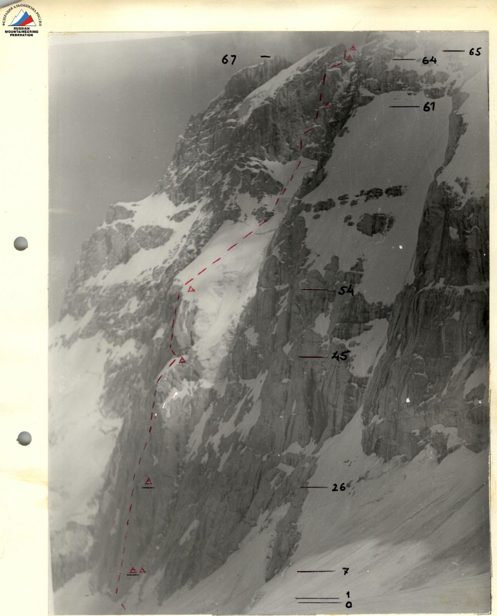
General view of the wall on the specified route and its division into sections
Profile view of the black triangle
| Section # | Name | Length, m | Steepness, ° |
|---|---|---|---|
| R1 | Snow-ice slope | 20 | 40 |
| R2 | Wall | 12 | 95 |
| R3 | Chimney | 8 | 80 |
| R4 | Wall | 12 | 90 |
| R5 | Slab | 4 | - |
| R6 | Inclined chimney | 6 | 75 |
| R7 | Rock ledge | - | - |
| R8 | Left slab | 35 | 80 |
| R9 | Right slab | 30 | 80 |
| R10 | Wall | 3 | 80 |
| R11 | Wall | 15 | 85 |
| R12 | Step | 0.3 | - |
| R13 | Wall | 4 | 60 |
| R14 | Overhang | 0.5 | 150 |
| R15 | Crack in the wall | 18 | 90 |
| R16 | Cornice with a crack | 0.5 | 160 |
| R17 | Slab (Summit) | 5 | 70 |
| R18 | Wall | 6 | 75 |
| R19 | Monolithic slab | 14 | 85 |
| R20 | Cornice | 2 | 135 |
| R21 | Triple slab | 9 | 95 |
| R22 | (No data) | - | - |
| R23 | (No data) | - | - |
| R24 | Upper slab | - | 95 |
| R25 | Smooth slabs | 32 | 80 |
| R26 | Ledge | 0.8 | - |
| R27 | Wall – ice-glazed rocks with water | 75 | 85 |
| R28 | (No data) | - | - |
| R29 | Ledge ice-glazed rocks | 18 | 88 |
| R30 | Wall with overhangs | 18 | 90 |
| R31 | (No data) | - | - |
| R32 | Wall with overhangs | 30 | 90 |
| R33 | Wall | 16 | 70 |
| R34 | Ledge | 4 | 70 |
| R35 | Monolithic slab, wet | 18 | 70 |
| R36 | Chimney | 12 | 90 |
| R37 | Ledge | 1 | 70 |
| R38 | Crack | 15 | 90 |
| R39 | Ledge | 2 | 80 |
| R40 | Internal corner with a crack, overhang | 24 | 95 |
| R41 | Monolithic slab | 20 | 80 |
| R42 | Overhang | 35 | 120 |
| R43 | Ledge | 10 | 60 |
| R44 | Monolithic slab | 30 | 60 |
| R45 | Snow-ice slope | 18 | 40 |
| R46 | Ice seracs | 15 | 70 |
| R47 | Ledge | 25 | 80 |
| R48 | Slab with an overhang, monolithic | 33 | 100 |
| R49 | Talus ledge | - | - |
| R50 | Monolithic wall, wet | 52 | 80 |
| R51 | Chimney | 15 | 95 |
| R52 | Slab | 12 | 80 |
| R53 | Broken wall | 27 | 85 |
| R54 | Talus shoulder | - | - |
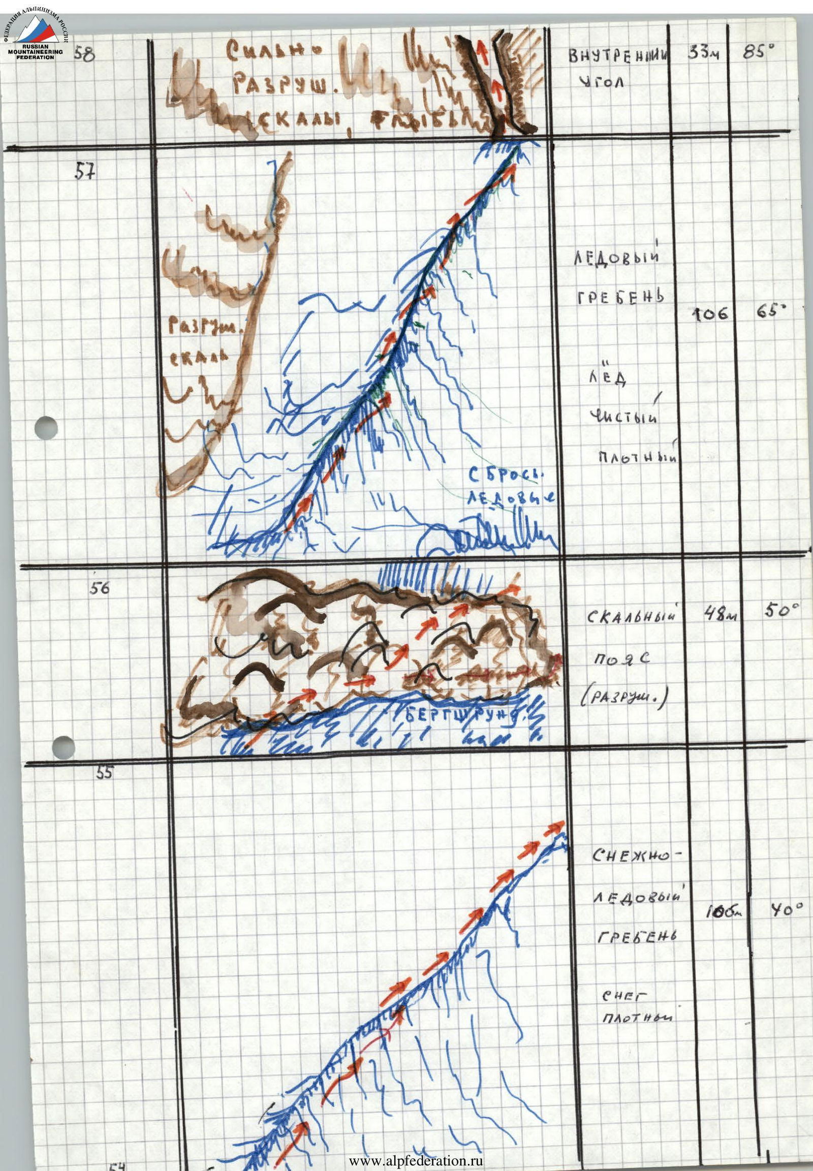
| R55 | Snow-ice ridge | 106 | 40 |
| R56 | Rock belt (broken) | 48 | 50 |
| R57 | Ice ridge | 106 | 65 |
| R58 | Severely broken rocks, couloir (Internal corner) | 33 | 85 |
| R59 | Unobvious ledge, monolithic slabs, water flows | - | 85 |
| R60 | Unobvious internal corner with two overhangs, cornice | 67 | 85 |
| R61 | Ledge | - | - |
| R62 | Slab | 92 | 85 |
| R63 | Ledge | 10 | 40 |
| R64 | Rock niches (Overnight stays) | - | - |
| R65 | Ridge, wall with an overhang | 90 | 85 |
| R66 | Rock ridge | 400 | 45 |
| R67 | East peak of Zamin-Karor | - | - |


2. General characteristics of the route passage
A. Route movement scheme:
- With a change of rope teams.
- Using a "long day".
- With a change of leaders in the rope teams.
Was fully executed. All team members worked on the route, of course, to varying degrees, as they considered three factors: the degree of effectiveness, the first, his specialization (dry rocks, ice, wet rocks, cracks, bolt work) taking into account the terrain requirements.
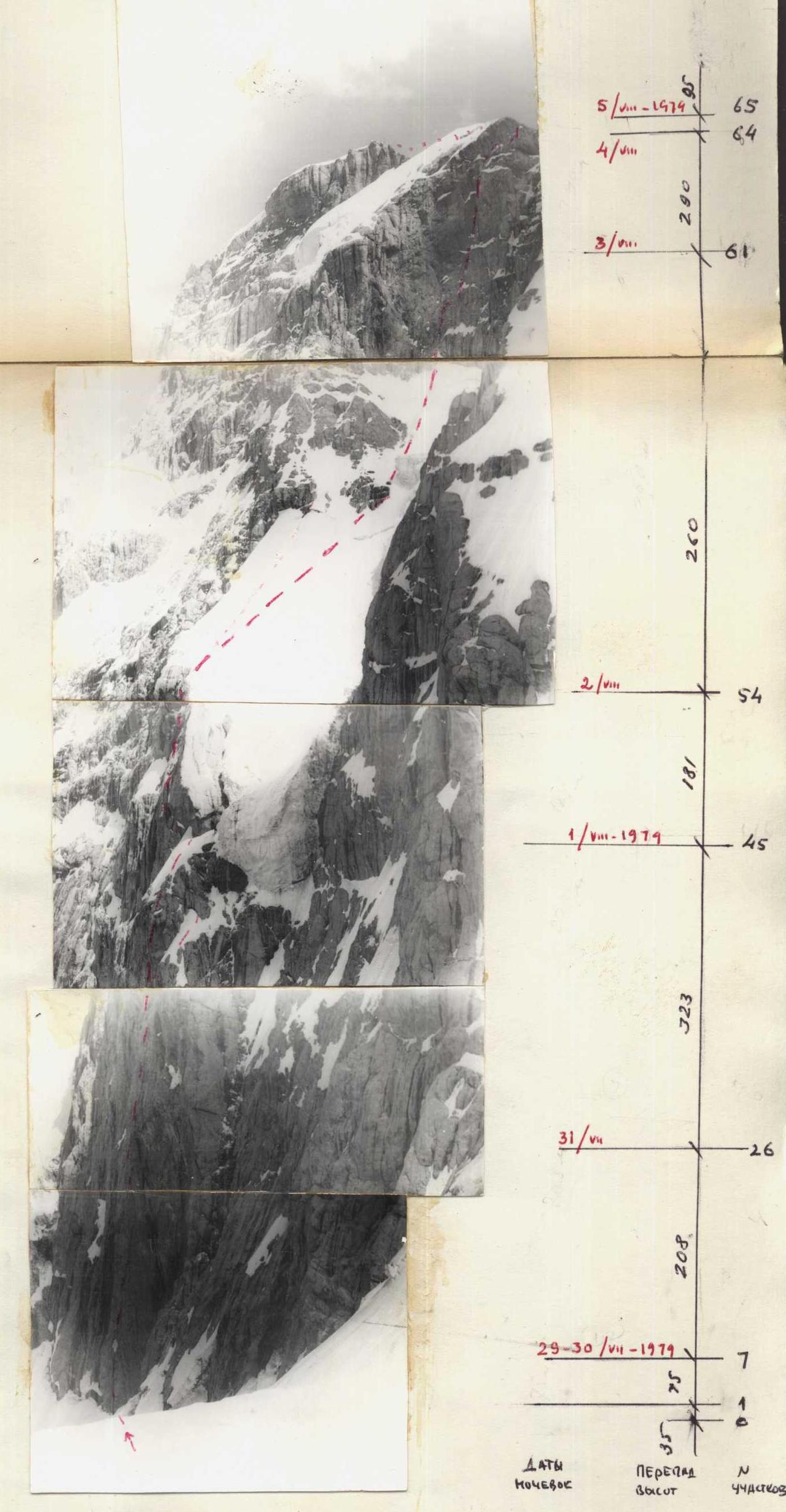
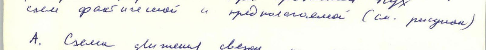
B. Analysis of the passage schedule: When comparing the expected and actual team schedule, several temporal and spatial discrepancies can be identified (see diagram):
I. When compiling the movement profile along the route, the team expected to pass the Triangle in 4 days. II. To pass the Triangle according to the scheme; processing above the ledge. III. On the 3rd day, quickly passing R0–R10 along the second bastion and spending the night somewhere under the second wall, possibly in a bergschrund. (More precisely, due to the isolation, absolute unknownness, it was difficult to guess and impossible to plan in detail a priori.) IV. To process 60–80% of the upper bastion and descend to the same overnight stay on the 5th day. V. On the 6th day, complete the passage of the upper bastion and spend the night on the ridge. VI. On the 7th day, dismantle the camp, walk along the ridge to the summit, drop off backpacks, descend to the summit, and within hours return to the base camp or the helicopter pad.
2.1. Daily description
- On the first day, the team reached the golden meadow overnight stay and processed R0–R10 above it, and it became clear that, unlike the expected nature of the rocks (view of the triangle), the belt of giant cornices had practically no cracks and had to be overcome using ladders and step-in pitons with the use of crack pitons, where only such equipment was required. (Internal difficulties: up to 5 days.)
- On the second day, the team overcame a series of cornices but extremely strenuous work to ensure safety, and the unusual terrain forced them to abandon the overnight stay on a small ledge as planned and descend back down. At the same time, we had already noted some tendencies to deviate.
- On the third day, the team left the overnight stay and processed R0–R15 above it, then a layer of the planned schedule.
- On the 4th and 5th days, however, it became clear that the upper part of the Triangle, with very complex terrain, mostly with destroyed, mossy water flows, had no cracks. The rockfall factor, not subject to terrain and the speed of passage of sections, thwarted our efforts despite all our attempts. As a result, the team passed the Triangle with a delay relative to the planned timing.
- On the sixth day, due to the circumstances listed, the team deviated from the planned scheme of passing the bastion with processing, descending, and then passing along the eight bastions "on the go". Moreover, due to unusually warm weather, the ice and snow on the Bastion began to melt sharply, making the overnight stay on the wall unsafe and giving preference to an uncomfortable but safe forest overnight stay (after a very difficult night).
- On the seventh day, the team practically returned to the planned schedule and at 15:00 reached the ridge; it would take a relatively easy ascent to the summit of the Bastion, approximately 1.5–2 hours, and a descent from the summit, approximately 4–5 hours, to reach the helicopter pad. We were supposed to be in the camp by 24:00. But a sharp deterioration in the weather, lightning discharges hitting 5–6 meters away, and a snowstorm blinded us, preventing us from descending 60 meters along the ridge, and thus the 7th overnight stay became forced and extremely difficult.
- The 8th overnight stay, which we moved to the ridge due to incredible difficulties, a snowstorm, was actually forced. At the same time, the weather was terrible, the team extended the control period, huddled together, and got wet.
- With the first clearing, we descended to the summit (on the evening of August 5) and the next day descended down.
Thus, the inaccessible nature of the smooth belt of cornices and water flows in the upper half of the Triangle were factors that led to an incorrect decision in advance. However, the subsequent decision did not allow the team to successfully pass this bastion according to the planned decision. And the team successfully completed the ascent in 7 days. Unfortunately, the weather, thunderstorm, and snow did not allow us to exit.