Ascent Passport
- Ascent class — technical
- Ascent area — Gissar Ridge
- Peak — Zamin Karor (Eastern) 4767 m, via the northwestern wall
- Proposed difficulty category — 5B
- Route characteristics: a) height difference — 1065 m; b) length of sections with 5–6 difficulty category — 1228 m; c) average steepness — 65°.
- Number of pitons:
- Rock — 101
- Ice — 48
- Bolts — 0
- Wooden wedges — 2
- Total climbing hours — 50.5
- Number of bivouacs and their characteristics: 4, one of which is a sitting bivouac
- Names of team leader and participants:
- Sobolev Vladimir Sergeyevich — Candidate Master of Sports
- Yanov Vitaly Fyodorovich — Master of Sports of the USSR
- Gavrishkin Valery Vladimirovich — Master of Sports of the USSR
- Gordeev Ivan Mikhailovich — Candidate Master of Sports
- Team coach: Semenyuk Valery Danilovich — Master of Sports of the USSR, 1st sports category
- Date of departure to the route July 30, 1979, and return August 3, 1979
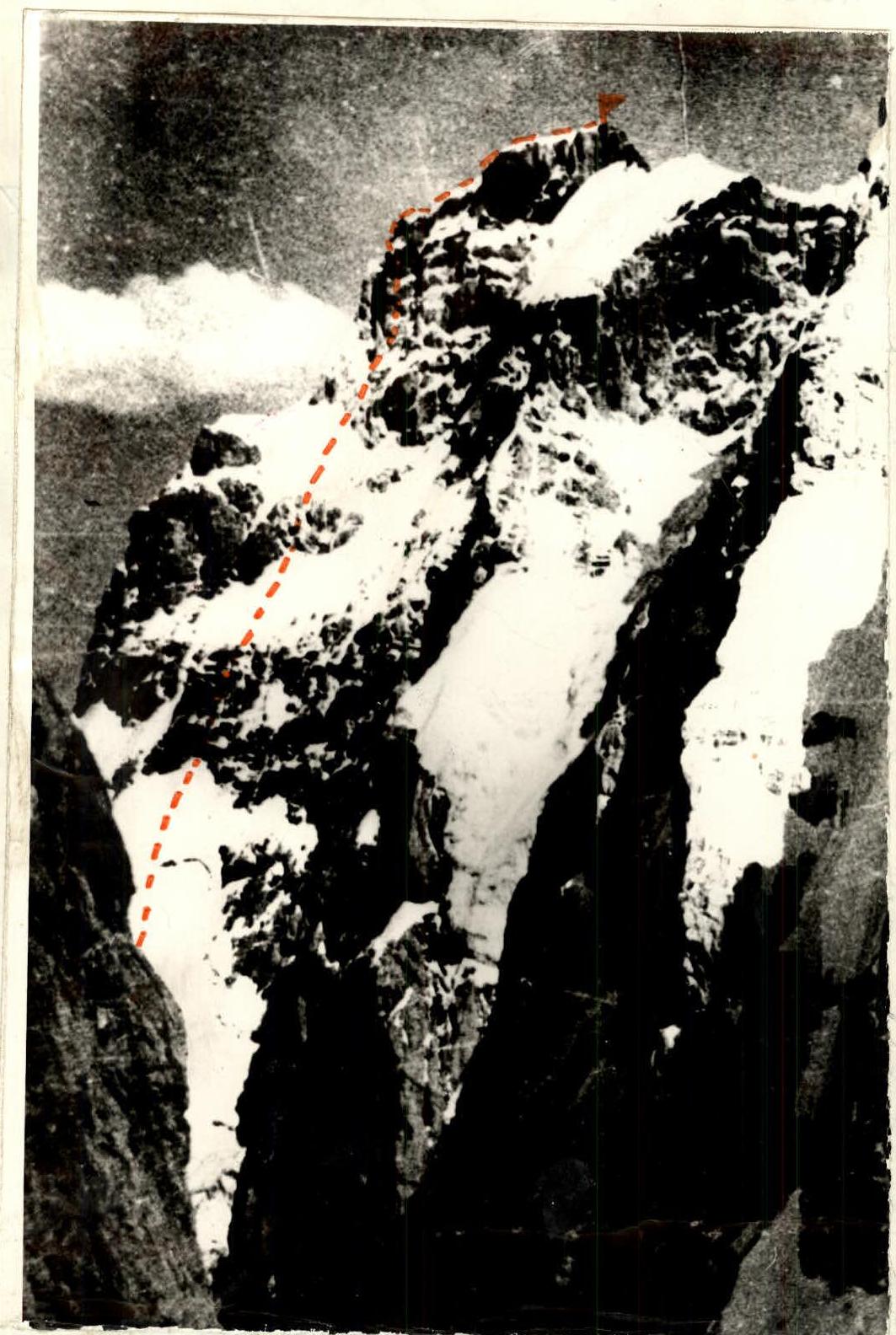
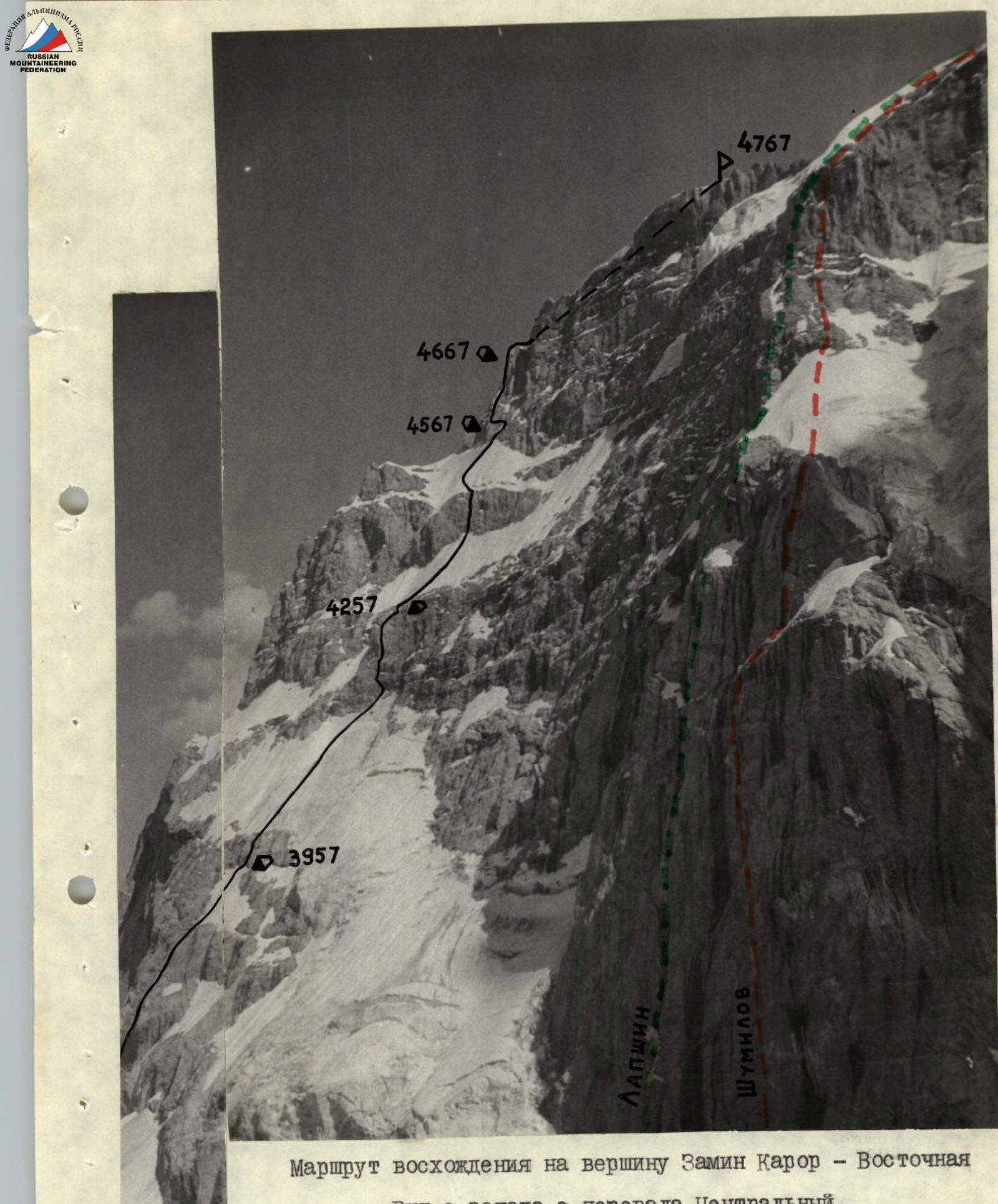
Ascent route to Zamin Karor Eastern peak. View from the west from the Central Pass
Brief description of the ascent route
The team from the Talgar alpine camp arrived at the site of the USSR Alpine Championship on July 26, 1979.
On July 27, the pair Gordeev I.M. — Yanov V.F. made a reconnaissance sortie through the Central Pass to:
- clarify the tactical ascent plan;
- determine the location of the assault camp.
On July 28 at 14:00, the team, along with the observation group, headed to the area of Zamin Karor Eastern peak. The observation group included:
- Rodikov A.P. — 1st sports category;
- Kholodnykh S.P. — 2nd sports category;
- team coach, Master of Sports of the USSR Semenyuk V.D.
The approach to the bivouac site took 4–5 hours. The observers' camp was set up on the lateral moraine of the glacier behind the Central Pass.
On July 29, the team continued to observe the planned route, and the pair Semenyuk V.D. — Sobolev V.S. made an exit under the route to capture the frontal exposure of the wall.
On July 30, the team began the ascent. At 6:00, the pair Sobolev V.S. — Gordeev I.M. started, and at 8:00, the second pair Yanov V.F. — Gavrishkin V.V. followed. The approach to the start of the route took 1.5 hours.
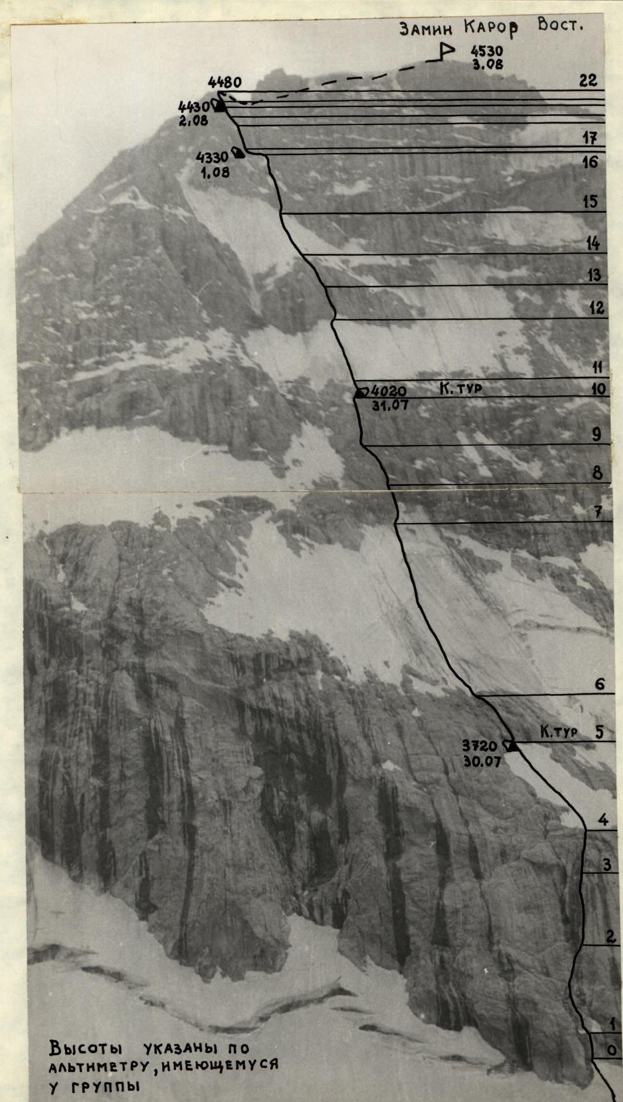
When starting the route, the group had an altimeter to measure the height of characteristic sections. The initial section — 3465 m — of the wall — a characteristic internal angle with slight icing (R0–R1). After 20 m — a snow cornice, the rocks are monolithic. The section was confidently climbed by Sobolev V.S. A rope was hung for the second rope team.
Further movement upward 80 m (R1–R2) was along smoothed rocks of various shapes:
- slabs;
- chimneys;
- angles;
- walls (65–70°). On the R1–R2 section, 5 pitons were hammered.
The most challenging section of the 1st day — a smooth wall 80° 40 m, starting to the right of a ledge. Minimal holds, almost complete lack of cracks for intermediate pitons. Yanov V.F. climbed the wall first, free climbing, wearing galoshes. Hauling of backpacks.
Along rocks of moderate difficulty (55°) 40 m to the right and upward to a snow-ice belt with a steepness of 50° (R4–R5), 80 m long, led to rocks where a niche in the ice was dug out for a bivouac.
Time 17:00. 1st control tour. July 31. Departure at 7:00. Start at 8:00. From the bivouac, the path went to the right 40 m along rocks of moderate difficulty under the ice belt. The R6–R7 section was climbed by the rope team Yanov V.F. — Sobolev V.S.
The ice belt, 55° steep, 240 m long, was traversed on front crampons with an ice axe and an adze with a curved pick. Insurance was provided through ice screws — 20 pieces.
Exit to a wall:
- Traverse to the right — 20 m
- Climb upward — 10 m
Transition to rocks.
Further, an internal angle led to a wall. From a ledge 35 m upward along the wall with cornices. 8 pitons. Yanov V.F. climbed the wall, also wearing galoshes. Hauling of backpacks. Section R7–R8.
Further along rocks of moderate difficulty to the right and upward to a chimney with a plug. The chimney — challenging climbing 40 m — was climbed first without a backpack. The chimney led to a ledge; traverse to the left 20 m, upward 10 m, and then to the right 10 m — a convenient ledge for a bivouac. Time: 20:30. 2nd control tour.
August 1. At 8:00, the rope team Gavrishkin V.V. — Yanov V.F. climbed straight up — 40 m — along destroyed rocks of moderate difficulty to an ice belt. The ice belt, 140 m long, with a steepness of 55–60°. Exit to rocks in a wide chimney (Caution — loose stones!) approximately 40 m.
From the chimney upward along the wall 10 m, then along the internal angle 20 m. From the internal angle along the wall to a ledge 15 m upward to the beginning of the ice belt. Time 15:30.
We decided to go up the ice ridge, covered with wet snow, which served as a divider for falling stones and ice. 160 m of the belt, with a steepness of 50–60°, were traversed with difficulty, as the upper layer of snow, soaked with water, clogged the crampons. The last 100 m were climbed without backpacks. The design of titanium ice screws proved useful!
The exit from the "knife edge" to the rocks was very challenging due to overhanging rocks and a lack of cracks. 40 m upward to the hauling of backpacks and a traverse to the left of the ice gully to a small overhanging wall 20 m. Then an exit to a sloping ledge 30 cm wide. Sitting bivouac. Time 21:30.
August 2. Departure at 8:30. From the bivouac:
- upward, an overhanging crack, for which a wooden wedge was used;
- above, the crack turned into a chimney filled with ice — 25 m;
- section R16–R17;
- hauling of backpacks.
Further 70 m upward along a concave wall of destroyed rocks. Challenging, cautious climbing. Difficult to hammer in pitons. Exit to a fragment. Section R17–R18.
From the fragment upward along the wall, then into an internal angle with small cornices to a ledge. Hauling of backpacks. Section R18–R19. We were under an overhanging destroyed wall, from which water was flowing. 25 m traverse to the left and 15 m down. Then 35 m upward to a niche. Under monolithic overhanging blocks — a bivouac site. Hauling of backpacks. Time 18:00. While the pair Gordeev I.M. — Gavrishkin V.V. were setting up the bivouac, the rope team Yanov V.F. — Sobolev V.S. worked on the section of overhanging rocks — 85–90°. When exiting from under the cornice, a wooden wedge was used. Section R20–R21.
August 3. Departure at 6:00. Start at 7:30, as the weather was deteriorating.
- Climb along fixed ropes
- Hauling of backpacks
Along a ledge, traverse to the right 5 m, then upward along the wall 40 m of fairly challenging rocks, and we were at the summit of the pre-summit bastion. Height 4480 m.
We untied and, after a short and simple traverse, climbed to the control tour. Height according to the altimeter 4530 m, which is significantly (by 200 m) less than indicated on the schematic maps.
We began the descent at 11:00 in the direction of the Ledovyy Pass. At 17:00, the team returned to the base camp.
Team's opinion on the route: Sobolev V.S. — "The route is comparable to the North Wall of Jigit Peak (Ryabukhin's route), which the team climbed before the championship". Yanov V.F. — "A good, powerful 5B in this area. Especially valuable because the route is combined with an abundance of ice and rocks". Gavrishkin V.V. — "The route was liked; it is more challenging than it seemed from below. In my opinion, the route is more difficult than the North Wall of Uzbekistan Peak (4th place in the 1977 USSR Championship)". Gordeev I.M. — "The route is challenging due to the abundance of rocks covered in ice. I believe the team coped with its task quite confidently".
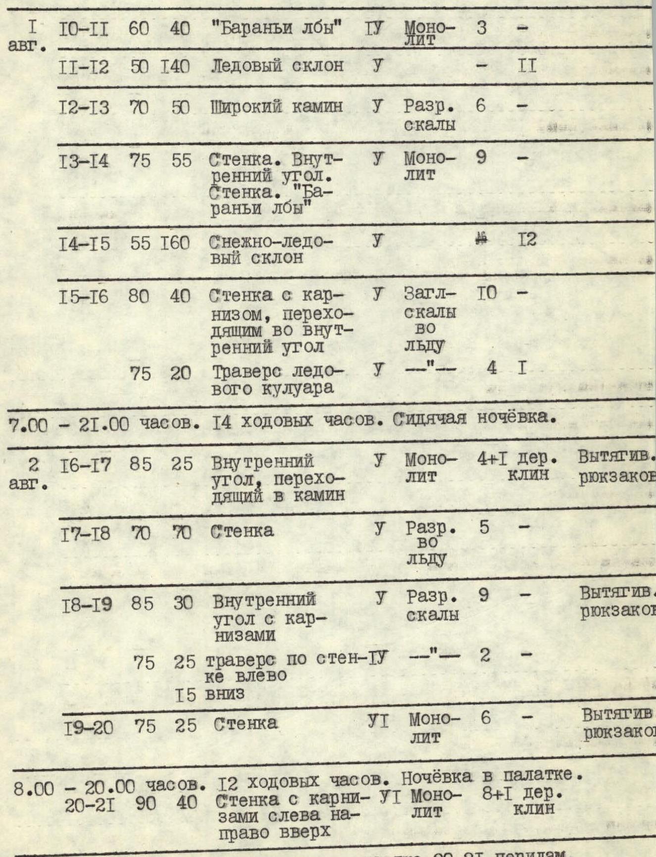
Table of main route characteristics
| Date | Designation | Average steepness in degrees | Length in m | Terrain characteristics | Difficulty | Condition | Rock | Ice | Notes |
|---|---|---|---|---|---|---|---|---|---|
| July 30 | R0–R1 | 80 | 20 | Internal angle | y | Icy rocks | 6 | — | — |
| R1–R2 | 65 | 70 | Smoothed rocks turning into a chimney with an exit to a wall | y | Icy. Monolithic | 5 | — | — | |
| R2–R3 | 80 | 40 | Wall | У1 | Smoothed monolithic rocks | 5 | — | Hauling of backpacks. 3 pitons | |
| R3–R4 | 55 | 40 | Ledges | Г1 | Destroyed rocks | 2 | — | — | |
| R4–R5 | 50 | 80 | Ice with snow | Г1 | — | — | 5 | 1st control tour | |
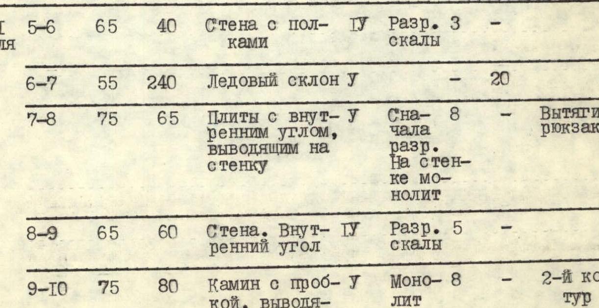
| July 31 | R5–R6 | 65 | 40 | Wall with ledges | Г1 | Destroyed rocks | 3 | — | — |
| R6–R7 | 55 | 240 | Ice slope | У | — | — | 20 | — | |
| R7–R8 | 75 | 65 | Slabs with an internal angle leading to a wall | У | Initially destroyed. On the wall monolithic | 8 | — | Hauling of backpacks | |
| R8–R9 | 65 | 60 | Wall. Internal angle | Г1 | Destroyed rocks | 5 | — | — | |
| R9–R10 | 75 | 80 | Chimney with a plug leading to a wall | У | Monolithic | 8 | — | 2nd control tour | |
| Aug 1 | R10–R11 | 60 | 40 | "Ram's foreheads" | Г1 | Monolithic | 3 | — | — |
| R11–R12 | 50 | 140 | Ice slope | У | — | — | 11 | — | |
| R12–R13 | 70 | 50 | Wide chimney | У | Destroyed rocks | 6 | — | — | |
| R13–R14 | 75 | 55 | Wall. Internal angle. Wall. "Ram's foreheads" | У | Monolithic | 9 | — | — | |
| R14–R15 | 55 | 160 | Snow-ice slope | У | — | — | 12 | — | |
| R15–R16 | 80 | 40 | Wall with a cornice turning into an internal angle | У | Smoothed rocks in ice | 10 | — | — | |
| 75 | 20 | Traverse of an ice couloir | y | — | 4 | 1 | — | ||
| Aug 2 | R16–R17 | 85 | 25 | Internal angle turning into a chimney | У | Monolithic | 4+1 wooden wedge | — | Hauling of backpacks |
| R17–R18 | 70 | 70 | Wall | У | Destroyed in ice | 5 | — | — | |
| R18–R19 | 85 | 30 | Internal angle with cornices | У | Destroyed rocks | 9 | — | Hauling of backpacks | |
| 75 | 25 | Traverse along the wall to the left | Т1 | — | 2 | — | — | ||
| 15 | down | — | |||||||
| R19–R20 | 75 | 25 | Wall | У1 | Monolithic | 6 | — | Hauling of backpacks | |
| R20–R21 | 90 | 40 | Wall with cornices from left to right upward | У1 | Monolithic | 8+1 wooden wedge | — | — | |
| R21–R22 | 70 | 40 | Internal angle, wall | y | Destroyed rocks | 4 | — | — |
7:00–17:00. 10 climbing hours. Overnight in a tent. 3 pitons for organizing a bivouac.
 8:00–18:00. 12 climbing hours. Overnight in a tent. 3 pitons for organizing a bivouac.
Aug 3. Climb along fixed ropes on section R20–R21. Hauling of backpacks.
8:00–10:30. 2.5 hours to the summit of Zamin Karor Eastern.
Pitons hammered: rock — 101, ice — 48, wooden wedges — 2.
Route length — 1628 m. Height difference — 1065 m. Total climbing hours — 50.5 hours.
Crossing the ice belt on section R11–R12