"... I felt offended that someone had been here before me, and at the same time I was proud of the human mind and will. From here, he had already conquered the mountains..." N. V. KRYLENKO "On unexplored Pamir"
Zamin Karor
Climbing history of the area
From V. Stukhin's report, 1976
Diagram # 3
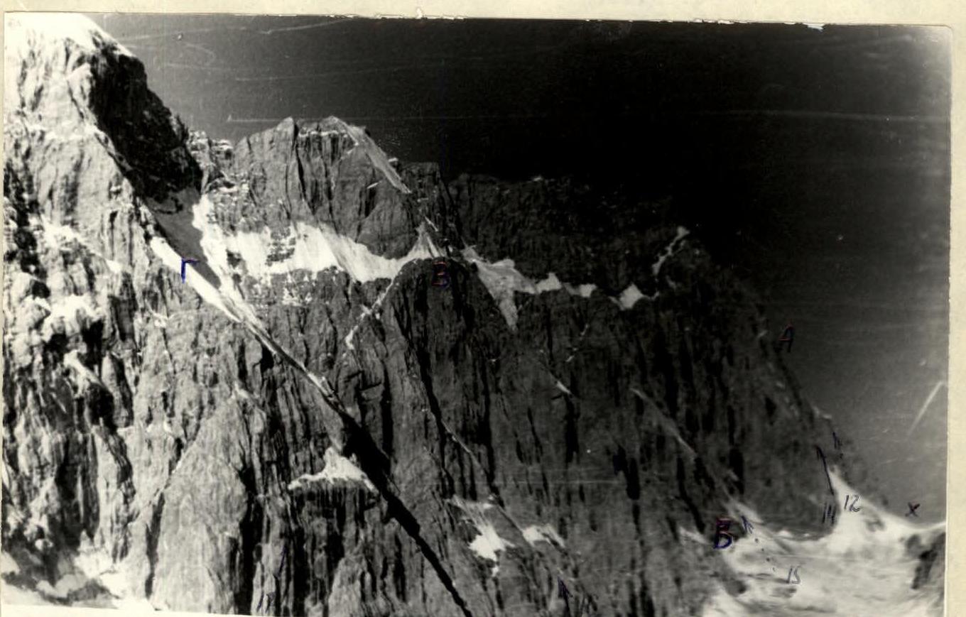
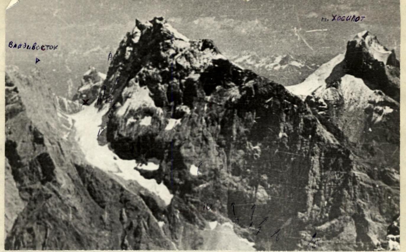
Photo # 1. X — pass Tsentralny
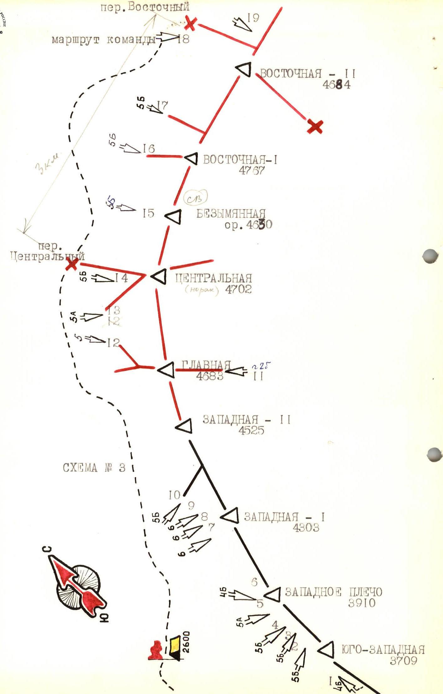
Photo # 2
To diagram # 3
| № | Year of ascent | Route name | Cat. diff. | Leader | Participants |
|---|---|---|---|---|---|
| 1 | 1973 | South-West (3709 m) via SW ridge | 4Б | O. Kislov | V. Bakman, Efremov, E. Kurkin |
| Zapadnoye plecho (3910 m) | |||||
| 2 | 1972 | via NW wall | 5Б | V. Rusanov | Sapoga, Sivtsov, Shatilov |
| 3 | 1974 | via right part of NW wall, non-category counterfort | 1А | M. Bylev | Burago, Lobachev, Mariel |
| 4 | 1972 | via NW wall | 5Б | V. Lavrukhin | Kurkin, Morozov, Prisla |
| 5 | 1974 | via NW wall through cave | 5А | O. Kapitanov | (?) |
| 6 | 1969 | via NW wall | 4Б | V. Petrov | Lavrukhin, Tkachev, Khardin |
| Zapadnaya I (4303 m) centre part | |||||
| 7 | 1971 | via NW wall | 6Б | G. Shramko | V. Bozukov, V. Vanin, I. Gavrilov, V. Markelov, M. Petrov |
| 8 | 1974 | shortest route via NW wall granite | 6Б | O. Kapitanov | Bezverkhov, Gusev, Lavrukhin, Yaroslavtsev |
| 9 | 1973 | via left part of NW wall | 6Б | V. Lavrunin | Kapitanov, Yanovich, Yaroslavtsev |
| Zapadnaya II (4525 m) | |||||
| 10 | 1970 | via NW wall | 5Б | L. Lapshin | Lavrushin, V. Petrov, Tkachev |
| Glavnaya (4683 m) | |||||
| 11 | 1969 | from south | 3Б | L. Lapshin | Lavrukhin, T. Solovyova |
| 12 | unclimbed | via NW edge | 1А | ||
| Tsentralnaya (4702 m) | |||||
| 13 | 1975 | via NW counterfort | 5А | V. Martynov | Azaryev, Vozhno, Storozhuk, Yatsko |
| 14 | 1971 | via N counterfort | 5Б | Yu. Akopdzhanyan | V. Danilov, V. Lavrushin, V. Prisyazhnyy |
| Bezymyannaya (NNE) (4630 m) orient. | |||||
| 15 | unclimbed | 1976 via N wall | 1Б | O. Kapitanov | |
| Vostochnaya I (4767 m) | |||||
| 16 | 1976 | via "Bolshoy treugolnik" from N | 5Б | O. Kapitanov | (?) |
| 17 | 1973 | via "Chyornyy treugolnik" from N | 5Б | L. Lapshin | Korvalin, Lavrukhin, Tkachev |
| Vostochnaya II (4684 m) | |||||
| 18 | 1976 | from N via edge | 5Б | V. Stukhin | Vakhmenin, Ivashchenko, Meshkov, Retonskiy, Tsukin |
| 19 | unclimbed | via NE ridge | 1А |
Brief geographical characteristics of the area
When you travel along the Dushanbe-Leninabad road, after descending from the Anzob pass into the Yaghnob valley to the Anzob village, you can't help but notice a light grey peak protruding from the surrounding mountains, dropping off with sheer walls to the north into the Yaghnob valley. The grandiose view of the peak makes a big impression.
Locals call it Zamin Karor, which translates from Tajik as "calm earth," i.e., mountains that have not suffered from earthquakes and rockfalls. Among climbers, another name has become widespread - "Yaghnobskaya стена" (Yaghnob Wall).
Indeed, Zamin Karor - "Yaghnobskaya стена" is located in the northern spur of the Gissar range, representing a separate high fold of the earth's crust, parallel to the main watershed of the Gissar range and dropping off with sheer walls to the north.
Zamin Karor is connected to the main watershed of the Gissar range by a relatively high but heavily destroyed ridge, where the peak Khosilot is located, striking in its beauty, with a height of 4626 m. North of Zamin Karor are separate, clearly defined peaks reaching a height of 4000 m. Their northern slopes descend into the Yaghnob valley.
This northern spur of the Gissar range is located east of the Anzob pass. It is bounded to the west by the Pindor river valley and to the east by the Tagrich river valley, both flowing into the Yaghnob river. In the southern part of the spur, there is the Tagrich pass, with a height of 3578 m, used by locals.
Between the peak Khosilot and the Zamin Karor massif, there is the Ledovyy pass (Glacier pass), named so by climbers from the "Khosilot" sports society (Dushanbe), where a small glacier about one kilometer long is located. To the west of the Ledovyy pass flows a stream that flows into the Pindor river. The lower part of the stream flows through a canyon with walls 200-300 m high. Above the canyon to the north, on the southern slopes of the western part of Zamin Karor, there is a sloping plateau covered with scree.
The northern end of the spur connects to the Zamin Karor massif with a short saddle, with a height of 3650 m, named by climbers as the Nurekchan pass.
Along the entire northern foot of Zamin Karor, a narrow strip of glacier is located. From the Nurekchan pass to the west, it flows (about 3 km) to a narrow and short canyon under the walls of the western peaks of Zamin Karor. The stream flowing from under the glacier flows directly into the Yaghnob river, turning north. To the east of the pass, the glacier is more extensive and descends down in several steep, heavily broken steps. The possibility of passage through the pass has not been established.
On the northern slopes of the eastern part of Zamin Karor, there are several hanging glaciers.
A characteristic feature of the area is the presence of separate, clearly defined peaks. The rocks are mainly composed of marbleised limestones, partially heavily smoothed. To the north, the peaks drop off with sheer and overhanging monolithic walls; to the south, they have more gentle slopes. The destruction of rocks on the southern slopes is superficial.
Climatic conditions are similar to other areas of the Gissar range and the Fann Mountains. In July, stable, clear weather with rare precipitation sets in. The area is warm, although on the northern slopes, where there is practically no sunlight, it is quite cold. The first snow falls at a height of 3500 m on the northern slopes at the end of September.
Vegetation is quite scarce. There are:
- barberry bushes;
- rose hips;
- small groves of dwarf birches.
History of the area's exploration
The first reconnaissance of the area was carried out by climbers from the "Khosilot" sports society (Dushanbe) in 1965 and 1966.
In 1967, while climbing the peak Anzob on the Zeravshan range, climbers from the "Khosilot" society paid closer attention to the massive wall opposite, naming it "Yaghnobskaya стена" (Yaghnob Wall) after the Yaghnob valley. Yaghnob translates from Tajik as "cold water".
In 1968, climbers from the "Khosilot" society again appeared in the area under the Western shoulder of the "Yaghnobskaya стена", conducted a more detailed study of the wall, and planned ascent routes.
In 1969, they planned to climb a route on the wall to win the republican championship. Therefore, in the spring of the same year, a group consisting of L. Lapshin, T. Solovyova, and V. Lavrukhin, conducted a reconnaissance of the descent, making a first ascent from the south (approximately route category 2B-3A) to the peak of the "Yaghnobskaya стена", which they named Glavnaya (Main), assuming it to be the highest point.
In August, a team from the "Khosilot" society, led by V. Petrov, consisting of V. Khardin, V. Lavrukhin, and V. Tkachev, climbed a route via the NW wall to the Zapadnaya I peak of the "Yaghnobskaya стена", winning first place in the Tajik SSR championship.
Planning to climb a new route on the Zapadnaya II peak the following year to win the republican championship, climbers from the "Khosilot" society in July 1970 again conducted a reconnaissance of the descent route from the Zapadnaya II peak. A group led by V. Tkachev during this reconnaissance made a first ascent to a peak located south of the "Yaghnobskaya стена", from the north via a snow-ice slope (route category approximately 2B), and named it peak Khosilot.
In August, a team from the "Khosilot" society, led by L. Lapshin, consisting of V. Petrov, V. Khardin, and V. Tkachev, climbed a complex and interesting route via the NW wall to the Zapadnaya II peak of the "Yaghnobskaya стена" and took second place in the Tajik SSR championship (first place was not awarded).
A bright page in the history of the area's exploration was written in 1971 by a combined team from NurekGESstroy and the Central Council of the "Burevestnik" sports society. A group led by G. Shramko, consisting of V. Bozukov, V. Vanin, I. Gavrilov, V. Markelov, and M. Petrov, climbed a route via the central part of the NW wall to the Zapadnaya I peak of the "Yaghnobskaya стена", category 6B, becoming champions of the USSR in the technically complex ascents category. Another team, led by Yu. Akopdzhanyan, consisting of V. Danilov, V. Lavrushin, and V. Prisyazhnyy, made an ascent from the Nurekchan pass via the north counterfort to the Tsentralnaya peak of the "Yaghnobskaya стена".
Several groups repeated the route by V. Petrov to the Zapadnaya I peak, the same year. Continuing research and exploration of the area, a group of climbers from the "Khosilot" society led by V. Tkachev climbed a new route from the west to peak Khosilot (category approximately 1B).
As a result of many years of effort by climbers from the "Khosilot" society in Dushanbe, the interesting area of the "Yaghnobskaya стена" became well-known among climbers in the country. However, not only the surrounding peaks remained unexplored; the "Yaghnobskaya стена" massif itself was far from fully studied, with its eastern part remaining a blank spot.
During the study of the area, climbers learned from local residents of the Margib village that the true name of the massif they called "Yaghnobskaya стена" was Zamin Karor.
Approach to the area
The Zamin Karor ("Yaghnobskaya стена") area is located approximately 100 km from Dushanbe. To get there from the city, you should take a car along the Dushanbe-Leninabad road (Dushanbe-Samarkand) through the Anzob pass to the bridge over the Yaghnob river. From here, you should walk along the left (orographic) bank of the Yaghnob river to the Margib village, about 2 hours.
Initially, for 1-1.5 km from the bridge, there is a road that ends at a canyon, squeezing the Yaghnob river from both sides. Further, the trail winds along the steep bank, partially cut into the rocks or laid out of stones over the turbulent Yaghnob river flow.
After passing the canyon, the valley expands sharply, and a grandiose view of the western part of Zamin Karor opens up.
The Margib village is located at the mouth of the Pindor river in a very picturesque place. Typical Tajik buildings with flat roofs and short, thick pipes - chimneys - harmoniously blend with the slender pyramids of trees. The bright, colorful clothing of women successfully complements the color palette of the landscape. Locals welcome climbers very warmly, although not many speak Russian.
Following the first village, about half a kilometer upstream, there is a second village. From it, the trail goes to the upper reaches of the Pindor river to the pastures. You should follow this trail to peak Khosilot. The same trail is used to return from ascents on Zamin Karor.
150-200 m above the upper village, a trail turns left, which steeply climbs to the plateau under the NW walls of Zamin Karor. The ascent takes about 1 hour. Here, on the upper plateau, near the stream, climbers usually set up their base camp.
Thus, the approach to the Zamin Karor wall from the road takes no more than 3 hours.
Zamin Karor ("Yaghnobskaya стена")
Before giving descriptions of ascent routes to the peaks of Zamin Karor, it is necessary to dwell in more detail on the characteristics of the massif.
Zamin Karor ("Yaghnobskaya стена") stretches for 8-10 km in a latitudinal direction, having several separate peaks at a significant distance from each other, of which the highest, 4767.5 m, is located in the eastern part - the Vostochnaya (Eastern) peak of Zamin Karor. No ascents have been made to the Vostochnaya peak yet.
Further to the west from the Vostochnaya peak, the most significant is the Tsentralnaya (Central) peak of Zamin Karor, named so by the NurekGESstroy team (led by Yu. Akopdzhanyan), who made the first ascent via the north counterfort in 1971. Its height is 4702 m.
The next peak, Glavnaya (Main), does not differ much in height. It was climbed by a group of climbers from the "Khosilot" society from the south during reconnaissance of the area in 1969. Measurements of the peak's height made by the group were close to 4767 m, leading them to mistakenly assume it was the highest point of the massif, naming it Glavnaya peak. The actual height of the peak is 4683 m.
The next peak to the west of Glavnaya was named by climbers from the "Khosilot" society - Zapadnaya II (Western II), with a height of 4525 m, who made an ascent in 1970 (led by L. Lapshin).
Further, there is the Zapadnaya I (Western I) peak, with a height of 4303 m, also named by climbers from the "Khosilot" society, who made an ascent via the NW wall through the Zapadnoye plecho (Western shoulder) in 1969 (led by V. Petrov). The same peak was climbed by climbers from NurekGESstroy and the Central Council of the "Burevestnik" sports society via the central part of the NW wall, winning first place in the USSR championship in 1971 (led by G. Shramko).
At the end of the ridge, there is another insignificant rise, named by climbers from the "Khosilot" society during their 1968 reconnaissance - Zapadnoye plecho (Western shoulder) (3709 m).
The eastern part of the Zamin Karor massif from the Vostochnaya peak to Glavnaya is located practically strictly in a latitudinal direction. Only the Tsentralnaya peak protrudes somewhat to the north. This section of the wall is the highest. Between the Tsentralnaya peak and Vostochnaya, there are separate higher points that have not yet been named.
From the Glavnaya peak to the west, the ridge begins to decrease sharply in height and deviates from the latitudinal direction to the south. The eastern ridge (east of the Vostochnaya peak) likely decreases even more steeply than the western one. No detailed reconnaissance of this section of the ridge has been conducted yet. Thus, the walls of the Vostochnaya, Tsentralnaya, and Glavnaya peaks of Zamin Karor have mainly a northern orientation, while the walls of the Zapadnaya peaks (I and II) have a NW orientation. This explains why the eastern part of the massif has significant glaciation, while the western part is purely rocky.
The average steepness of the walls in the area of the Zapadnoye plecho is 75°. The NW wall of the Zapadnaya I peak is the steepest, at 85°, with many overhanging sections. The walls of the Zapadnaya II, Glavnaya, and Tsentralnaya peaks are within 70-75°. The steepness of the northern walls of the Vostochnaya peak is within 60-70°, but these routes present exceptional difficulties due to significant glaciation and a large height difference.
The height of the wall varies in different sections. It is greatest in the eastern part (up to 2 km), where the glacier descends steeply, and the ridge has the highest mark. The northern walls of the Tsentralnaya peak have a height difference of 1000 m (Nurekchan pass 3650 m, peak 4702 m). Further to the west, simultaneously with the decrease in the height of the ridge, the base of the wall also decreases. This results in the average height difference of the wall remaining approximately 1000 m on average.
The southern slopes of Zamin Karor are heavily smoothed, relatively gentle, and covered with products of surface destruction.