Central Council of the Voluntary Sports Society "TADJIKISTAN"
Alpinist camp "VARZOB".
DESCRIPTION OF THE FIRST ASCENT TO THE SUMMIT "BLIZNETSY" VIA THE NORTHEAST COUNTERFORCE (PAMIR-ALAI, REGION OF THE "VARZOB" ALPLAGER).
Dushanbe – 1968
Introduction
To continue exploring the mountain region near the "VARZOB" alpinist camp, and to further the sporting growth of alpinist-discharge holders and instructors, the "VARZOB" alpinist camp organized an ascent to the summit "BLIZNETSY".
By participating in ascents to neighboring peaks: "VARZOBSKAYA PILA", "KRYL'YA TADJIKISTANA", instructors from Dushanbe had long been eyeing the northern slopes of "Bliznetsy" — steeply falling walls 1.5–2 km long — in the gorge of the "MAYKHURA" river. It was probably then that the idea of traversing the northeast counterforce of the "BLIZNETSY" peak was born.
The peak was named "BLIZNETSY" back in the early days of alpinism in Tajikistan (1952–1953). When viewed from the south, all three elevations of the peak have absolutely identical outlines, while from the north these outlines are lost.
Geographical and Alpinist Characteristics of the Region
The massif that includes the "BLIZNETSY" peak occupies an intermediate position between "TIA-N'SHAN'" and "PAMIR" and is known as "PAMIRO-ALAI".
The peak is located in the spurs of the Gissarsky ridge, between the "MAYKHURA" and "SIOMA" rivers. The highest point in this region is Peak KAZNOK — 4980 m.
Geological Structure
The formation of the "PAMIRO-ALAI" ridges is usually attributed to the Upper Paleozoic folding. These mountains arose before the ridges of the Pamir proper. Subsequent mountain-building cycles complicated the geological structure of the ridges and determined the modern relief.
The Gissarsky ridge is composed mainly of clay shales and limestones with local inclusions of igneous rocks — granites, diorites, etc. Overall, the ridge has an asymmetrical profile: steeper northern and gentler southern slopes.
A great diversity of relief forms is observed. The peaks are characterized by the presence of northern walls (up to 1000–1200 m), towers. The mountain ridges abound in gendarmes and are composed of large blocks.
The climate of this region is distinguished by continentality, with a short snowy winter and a hot, prolonged summer. Precipitation is not heavy (1200–1300 mm). The maximum precipitation occurs in the second half of winter and spring. From July to October, dry, warm weather usually sets in. The snow line lies at altitudes above 3000 m. A feature is the absence of very strong winds and prolonged bad weather.
GLACIATION. In past epochs, the mountains were subjected to repeated glaciation. An ice sheet covers the upper reaches of the MAYKHURA river. Currently, numerous traces of a powerful ice cover remain in the form of moraines, glacial lakes, and numerous short glaciers: cirque and valley glaciers. On steep slopes, hanging ice is retained, periodically collapsing downwards. Glacier nourishment occurs mainly due to avalanches and the collapse of ice masses. In summer, the surface of the glaciers is covered with calgaspores.
RIVERS. Meltwater from glaciers and snowfields gives rise to rivers. The rivers "SIOMA" and "MAYKHURA" are notable for their high water content.
VEGETATION: The altitudinal belt of 1800–2000 m is characterized by a hot summer and snowy winter. Here, poplars and willows grow. There are many shrubs: rose hips, currants. At an altitude of around 2200 m, juniper appears, and at around 3000 m, woody vegetation gives way to meadows, which are replaced by rubble slopes and rock outcrops.
ALPINISM CHARACTERISTICS OF THE REGION. Alpinist exploration of the region began in 1952 by Martynov, Kazakova, Popogrebsky, Lutsik, Shukurov, who conquered the peaks: "Varzobskaya pila", traverse "Kryl'ya Tadzhikistana", "KAZNOK". These peaks are categorized as 2nd, 3rd, 4th category of difficulty. The peaks are located not far from the automobile road — Dushanbe — Leninabad.
The approach to Peak Bliznetsy is made from the gorge of the MAYKHURA river. A short lateral gorge is located 5 kilometers from the fork in the road Dushanbe — Ziddy — Maykhura.
In this region, alpinists still have much to accomplish on the northern slopes: the northern walls of the peaks "Kryl'ya Tadzhikistana", Peak "Oktyabr'", "Mirokaya", as well as unascended peaks in the upper reaches of the Maykhura river, await their conquest.
The ascent to the summit "BLIZNETSY" via the northeast counterforce was made by a group of instructors from the "VARZOB" alpine club, consisting of:
- ABDULAEV E.S. — Candidate Master of Sports — leader.
- DYAPIN Z.F. — Candidate Master of Sports — participant.
- SARATOV Y.S. — Candidate Master of Sports — participant.
- DAVRUSHIN V.I. — Candidate Master of Sports — participant.
- RIZAEV L.M. — 1st sports category — participant.
Route Description
We travel by car along the Dushanbe — Leninabad highway until we reach the turnoff to Maykhura and continue in the direction of Maykhura for about 5 km from the fork. At the stream, we get out of the car, cross the Maykhura river via a pedestrian bridge, and ascend along a wide trail to a pasture plateau. From the plateau, we turn into a wide gorge that leads under the northern walls of the peaks "Kryl'ya Tadzhikistana" and "Bliznetsy".
We set up a storm bivouac on the upper moraine. The travel time from the highway is 3–3.5 hours.
Day 1
The group set out on the ascent at 7:30. After traversing the scree, we reach a snowy slope with a gradient of 30° and within 30 minutes arrive at the bergschrund under the counterforce. From below, a safe and logical route along the counterforce is visible up to the level of the icefall located on the left. The altimeter reads 3100 m.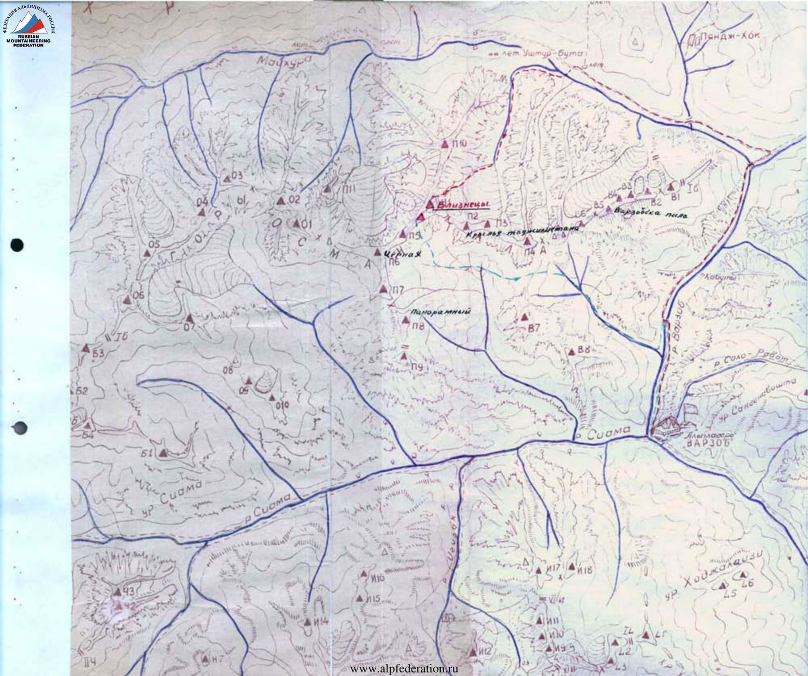
Section 1
After passing the bergschrund, we enter a scree-filled couloir, which ends after 15 m with a two-meter wall. The rocks consist of gray and black marble with white veins. There are very few cracks for hammering in pitons.
The first climber, standing on his companions' shoulders, hammers a piton into the top of the wall and continues up the couloir. The couloir is filled with snow lying on the scree. The snow slope is 45° steep and 20 m long.
Next, we encounter a gray marble wall with a steepness of 75° and a height of 20 m (the angle of inclination was measured with a geological compass).
The wall has few handholds. Movement is only possible in rubber-soled footwear. Three pitons are hammered in. Along a heavily destroyed couloir with a steepness of 65°–70°, we reach the ridge of the counterforce. The length of the couloir is 50 m. Three pitons and three wedges are used.
The overall steepness of the section is 65°, and the time taken is 2 hours 30 minutes. The length of the section is 130 m. Movement throughout the section is with alternating rope protection, interaction between rope teams, and the use of fixed ropes.
On the ridge of the counterforce, there is a good platform, but it is not advisable for all participants to gather there due to the risk of ricocheting icefall debris.
Section 2
Further movement is along the ridge of the counterforce. The ridge is destroyed. 20 m of easy rock leads to a yellow rock with an overhanging black wall, 10–12 m high. There are no handholds, but there is a winding crack — 4.5 cm wide, expanding to 30 cm at the top.
By wedging hands and feet into the crack, the first climber manages to ascend to a ledge relatively easily. Movement with backpacks becomes extremely difficult.
Further movement along slopes of medium difficulty — 30 m — is with alternating rope protection. Two pitons are hammered in.
- Length of section: 60 m
- Height: 3250 m
Section 3
The start is 10 m to the left of the ridge; an отвесная wall 4 m high is encountered, which is ascended using a hammered-in wedge as an artificial aid and for protection.
Next, 20 m of easy rock leads to the ridge and then along the ridge to a scree shoulder with a snow patch.
Above the snow patch, there are walls 20 m high with a steepness of 70° and good handholds and footholds. After the wall, we encounter smooth marble slabs where rubber footwear provides good traction.
The section is of medium difficulty; 5 pitons and 3 wedges are used.
Length — 110 m.
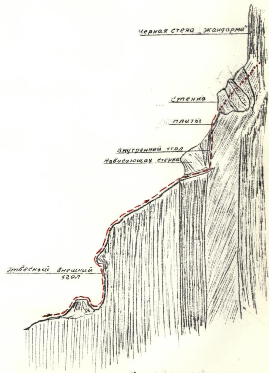
Section 5
A 20-meter internal rock angle with a steepness of 65–70° is ascended mainly on friction, using wedges and pitons as artificial aids. Along slabs inclined to the left, we traverse 10 m to the ridge and then descend 5 m into a saddle, after which we traverse to a "gendarm" and exit to a scree shoulder on the ridge. The length of the section is 70 m. Three wedges and 2 pitons are hammered in.
Section 6
By traversing the ridge to the left along a scree ledge for about 30 m, we approach a chimney 5 m high. The chimney narrows at the top and has an overhang. It is easier to ascend to the left of the chimney along a vertical (90°) wall, also 5 m high. Next, we follow an scree-filled couloir for 30 m, exiting onto a scree shoulder. A good platform can be established here. To the left of the couloir, 30 m away, water flows from snowfields lying above the gendarmes. The section is straightforward. Length 60 m. One piton is hammered in. Height 3450 m. Time 15:30. Three climbers work on the next section, but the further path is very complex. After fixing 100 m of ropes, the participants return to the ledge at 20:45.
Section 7
Along a lateral shoulder, we approach a wall closing the couloir. The wall is 10 m high with inclined ledges. The climbing is challenging. Further, along a steep inclined ledge 5 m long. Slightly left and upwards along a crack 10 m high. The wall is complex, requiring thorough and flawless piton protection. The exit is a wall with a negative angle.
Next, 30 m of inclined, polished slabs follow. Rubber footwear provides good traction. The section is of medium difficulty.
Length of section 70 m, 4 pitons hammered in.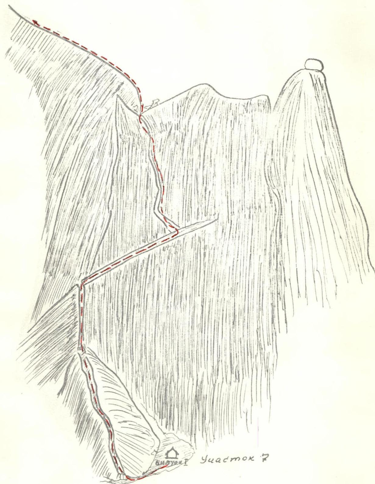
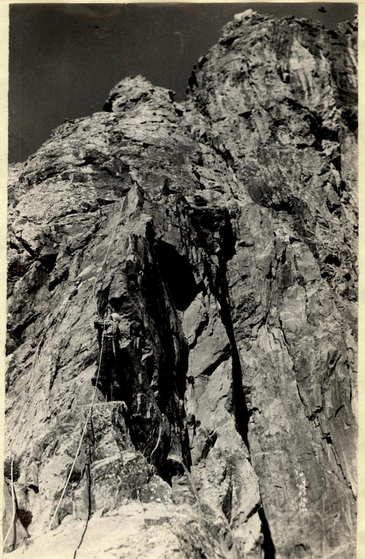
Section 8
Ahead lies one of the most complex and beautiful sections of the route. A sharp, narrow rock ridge, rising vertically, transitions at the top into an overhanging tooth. The height of the ridge from its base (the base is in a saddle) to the top of the tooth is approximately 10 m. Further, 15 m of steep (60°) ridge follows, with unreliable, loose handholds.
An attempt to bypass this section is unsuccessful. The lead climber ascends this section in Asian-style gaiters.
Pitons are used for protection, for pulling up from below, and as artificial footholds.
With the help of two four-rung ladders, the tooth is reached. Under the tooth, there is a horizontal crack. An attempt to hammer in a piton or wedge is unsuccessful due to the fragile rock. By inserting a piton into this crack and hanging a ladder on it, the first climber, with great strain, pulls himself up to a more gentle part of the ridge using his arms.
After traversing 15–20 m, the climber reaches a ledge from which it is convenient to pull up backpacks. Having secured the rope, the group bivouacs on a platform prepared by the two remaining climbers.
This is a very complex section:
- Length of section — 35 m
- 8 pitons hammered in
- Time taken by the lead climber — 3 hours
Day 2
Departure at 8:00. The group ascends one by one along the ropes fixed the previous day. Sections 7–8 are traversed, and backpacks are pulled up. 4 hours 30 minutes are spent.
Section 9
From the ledge to which the backpacks were pulled, we move 5 m to the right to bypass an overhanging wall. Ahead, again, lies a wall with an internal angle, 20 m high and 80° steep. This is a very dangerous section. The belayer and the rest of the group are in shelter behind the overhanging wall. Huge rocks rumble past the participants. Next, 5 m of slabs with a steepness of 50°, then a three-meter wall to the left, leading to the ridge. The ridge is 15 m long. Heavily destroyed slabs with a steepness of 50° follow.
The section is technically not complex but is very dangerous due to loose rocks. There are enough cracks and fissures for hammering in pitons. Length of section 60 m. 6 pitons hammered in.
Section 10
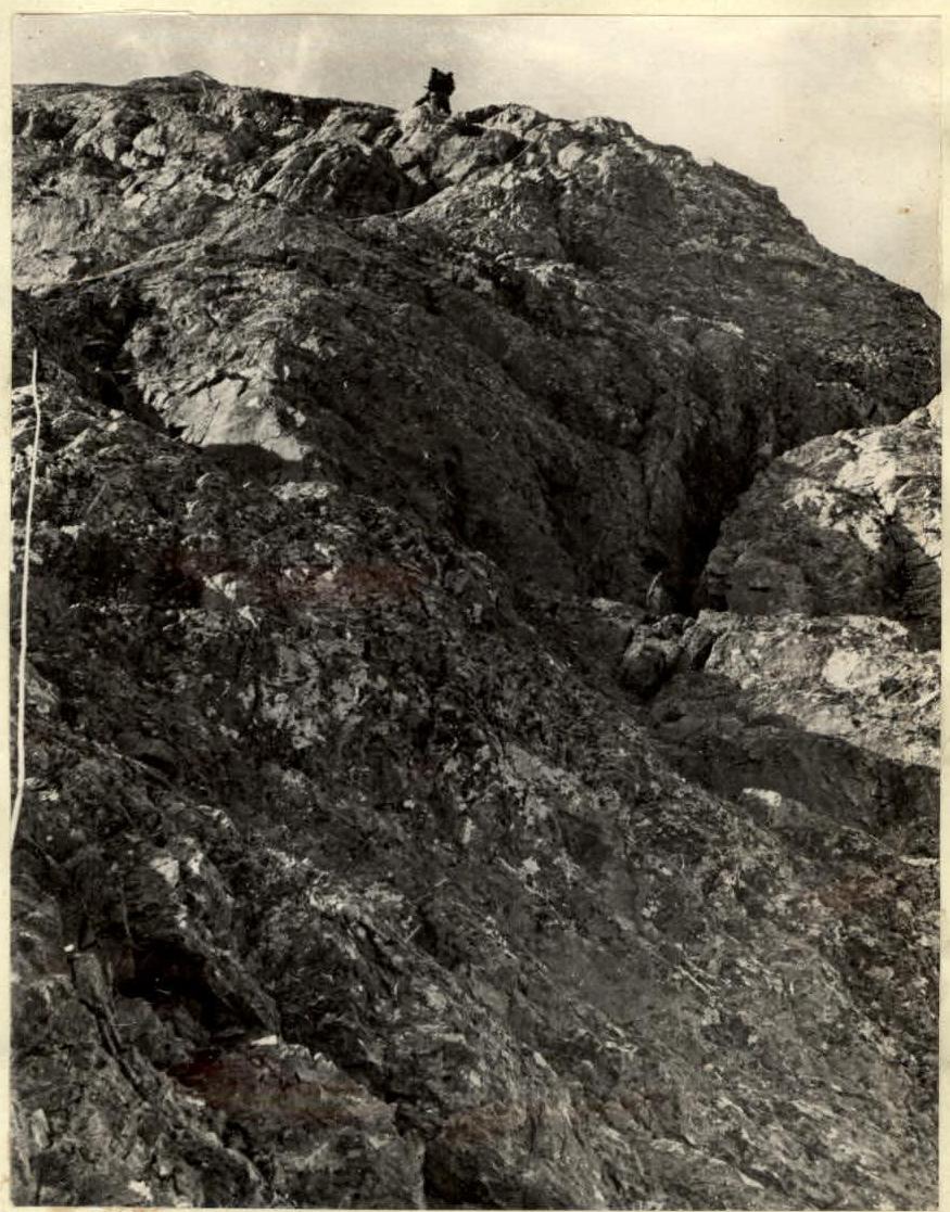
Along black slabs with a steepness of 55–60°, we ascend under a yellow overhanging rock. The southeastern part of the rock is a vertical black wall. Under the yellow rock, there is a small inclined ledge where two people can stand. The ascent to the top of the rock is only possible by traversing the southeastern wall. The ledge at the wall narrows and disappears.
After hammering in 3 pitons on the ledge, the first climber ascends the southeastern wall. There are no cracks or fissures on the wall. Handholds are smoothed. It is necessary to traverse 7–8 m, and the further path is deemed uncomplicated.
Leonid Rizaev literally presses himself against the wall, stretching out to his full height, and, with great care, inches his way up the wall.
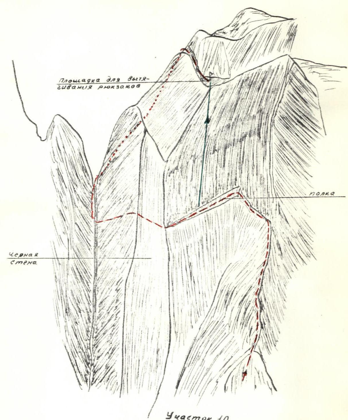
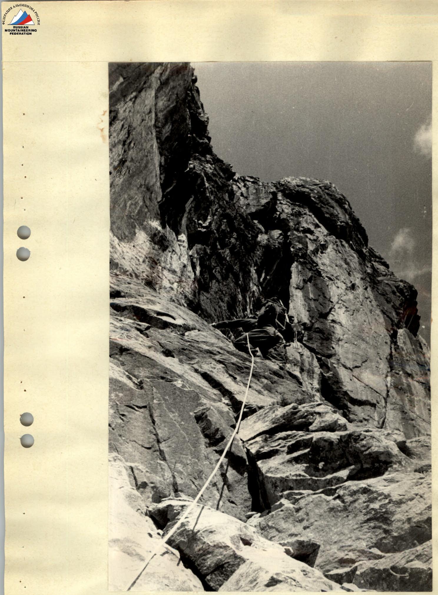

Traversing the challenging wall on Section 10
Another 25 m of traverse along relatively easy rocks leads to a couloir where water flows. The exit from the couloir is via easy rocks, 25 m, onto a snowy plateau bounded on the left by the main mountain ridge and on the right by the northeast counterforce.
Backpacks are pulled from the ledge to the top of the yellow rock. For this, two participants descend 15 m to a platform at the edge of the overhang and set up a system using a block and a clamp. The wall is the second key section of the route. Extremely challenging climbing on a vertical wall, dropping down a hundred meters, requires excellent rock climbing technique.
Length of section 80 m. 9 pitons hammered in. Very difficult section — 8 m. Height 3600 m. Time 18:00.
Section 11
A straightforward, almost horizontal ridge follows. Slopes to the left are scree covered in snow.
The first gendarm on the ridge is bypassed on the left via snow. Further movement is along the ridge, along easy rocks, with alternating rope protection.
After the second gendarm, we descend 10 m into a saddle.
It is possible to bypass the second gendarm on the left along scree ledges, exiting into the same saddle.
A bivouac is set up in the saddle. Time — 19:30. The section is uncomplicated.
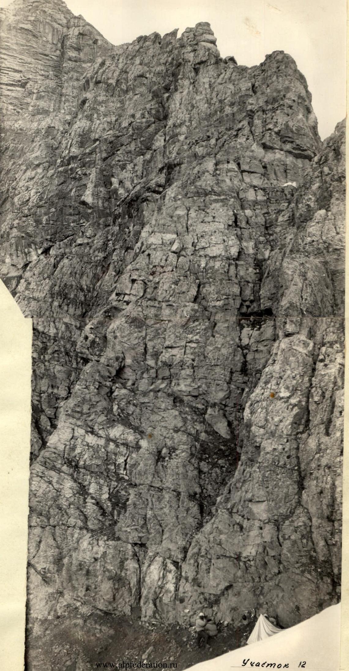
Day 3. Section 12
Departure at 8:00. 10 m from the ridge, along a rocky couloir, 60 m of easy climbing follows, then 20 m along a steep crack. We exit onto the ridge and, bypassing the first rocky tower on the right of the ridge, initially descend along a wide inclined ledge, then ascend along a rocky couloir into a saddle with a snow patch. From the saddle, 30 m along the ridge, then left along a three-meter chimney with a plug, then 20 m along the ridge, followed by a 20 m traverse on a ledge to the left. Ahead, inclined slabs 20 m long with a 45° angle of inclination lead to a pass before the tower.
The section is of medium difficulty. Length of section 170 m. 3 pitons hammered in.
Section 13
The overall steepness of the northern edge of the pre-summit tower is 45°. The first 40 m are a heavily indented slope with numerous handholds and footholds. The next 20 m are rough marble ridges and slabs with a steepness of up to 60°. Large ledges and cracks are entirely absent. Careful climbing initially upwards, then 3–4 m to the right through a rocky gutter leads to a 60 m high outcrop for setting up protection.
From the outcrop, 5 m upwards along a rough ridge, then along an inclined ledge to the left and upwards, but not to the end — halfway along the ledge, we turn right along a four-meter vertical wall, followed by rough slabs.
To bypass an overhanging tower on the ridge on the left, we traverse along slabs, followed by another five-meter wall, and along a destroyed ridge for 10 m onto a scree ledge.
Next, pre-summit slabs follow, dropping off onto a ridge with overhanging walls. To bypass the overhanging walls, we move 5 m to the left onto a dissected rocky ridge; further upwards and to the right, 10 m along an internal angle formed by the ridge and slabs. Having bypassed the angle, we exit onto the northeast summit. The summit tower is a marble massif without cracks or fissures, requiring very careful and cautious climbing due to the impossibility of setting up substantial piton protection.
Length of section 180 m. 5 pitons hammered in. Height 4172 m. Time — 13:00.
Descent from the northeast summit to the pass and ascent to the middle summit follow the classified route of category 2B difficulty.
The group completed the route in 30 travel hours. 57 pitons were hammered in. For ascending along the fixed ropes, the group used metal clamps.
The group had the following equipment on the route:
- Vibram-type boots — 5 pairs.
- Backpacks — 5 pcs.
- "Pamirka" tent — 1 pc.
- "Zvezda" tent — 1 pc.
- Down sleeping bags — 3 pcs.
- Down jackets — 5 pcs.
- Down pants — 3 pcs.
- Harness belts — 5 pcs.
- Personal karabiners — 25 pcs.
- Rock hammers — 2 pcs.
- Ice axes — 3 pcs.
- Ice axes with pick — 2 pcs.
- Main rope 60 m — 2 pcs.
- Auxiliary rope 30 m — 2 pcs.
- First aid kit — 1 pc.
- Helmets — 5 pcs.
- Storm suits — 5 sets.
- 4-rung ladders — 2 pcs.
- 10-meter ladder — 1 pc.
- Various rock pitons — 30 pcs.
- Duraluminum and titanium wedges — 15 pcs.
- Self-belay loops 5 m — 5 pcs.
- Food supply for four days.
- Various flares (red, green) — 5 pcs.
Communication with the observer was maintained by signal flares daily at 22:00.
All participants in the ascent are experienced alpinists and instructors, having repeatedly undertaken ascents along routes of the highest category of difficulty in the Caucasus, Pamir, and Pamiro-Alai.
The group unanimously evaluates the traversed route as a purely rock route, technically challenging, category 5A difficulty.
DESCRIPTION COMPILED BY: ABDULAEV E.S.