Open Championship of Sverdlovsk Region on Alpinism
Report on the ascent to the peak Bivachnaya 3700 m via "diagonals" of the Western wall, approximately 5B cat. diff., made by the team of Chelyabinsk Regional Council of the DSO "Burevestnik"
Team leader and coach
Igolkin V.I.
1987
Chelyabinsk Regional Council DSO "Burevestnik" Address: 454080, Chelyabinsk, Lenina ave., 78 Chairman of the Regional Council - Deyneko Sergey Ivanovich, work tel. 39–91–01 (transformed into the sector of student sports of the Regional DLSO of Trade Unions)
Team leader and coach Igolkin Viktor Ivanovich
Address: 455000, Magnitogorsk, Lenina ave., 37–18 home tel. 2–71–86, work tel. 7–05–05
The heights marked in the report were determined according to the classification table of mountain peak routes of the USSR.
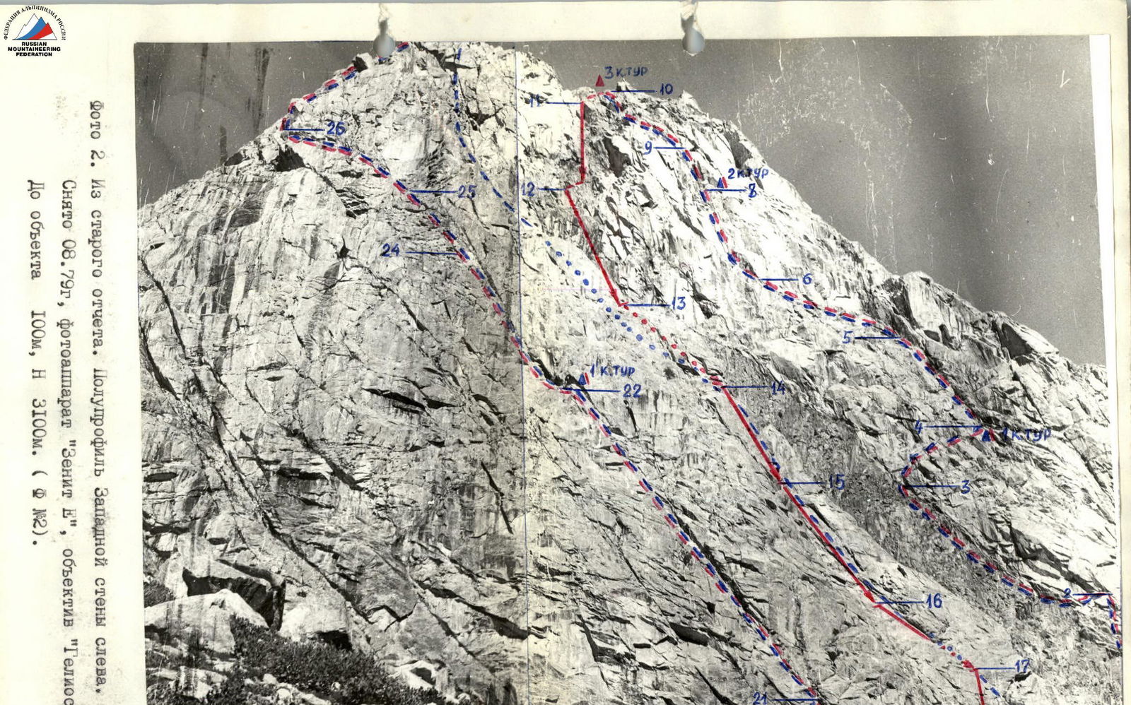
Photo 2. From an old report. Semi-profile of the Western wall from the left. Taken 08.79, camera "Zenit E", lens "Helios". Distance to the object 100 m, H 3100 m. (F №2).
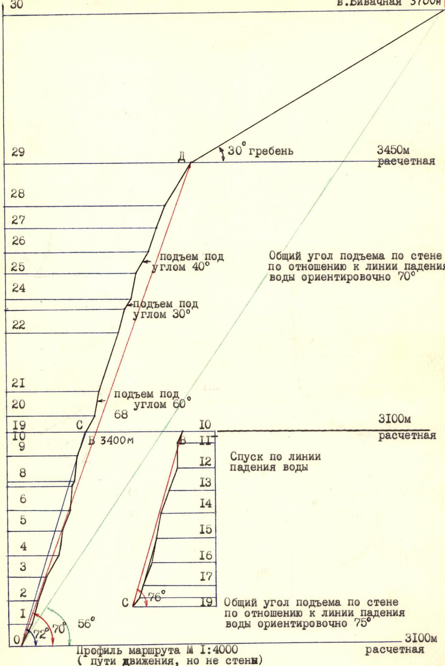 Profile of the route M 1:4000 (path of movement, not the wall)

Map-scheme of the area M 1:100000
Brief overview of the climbing area
The Igizak region is the most popular and frequently visited area of the southern spurs of the Gissar ridge. This popularity is due to:
- Firstly, its close location and accessibility for both AUSB "Varzob" and for climbers and residents of Dushanbe.
- Secondly, the presence in a relatively small area of numerous routes (over 30) with a length from 1B to 4B cat. diff., including more than half - 3-4 cat. diff.
The stable good weather in the area contributed to the fact that the routes (mainly rock climbing) are generally half a category more difficult than in other mountainous areas, while the vast majority of routes are wall climbs.
From the turn of the Dushanbe-Leninabad highway at the confluence of the Siama and Maikhura rivers, forming the Varzob River, the trail leads up first along the right (orographic) bank of the Siama River to the hydrologists' post (1.5-2 hours).
Further from the confluence of the Igizak and Siama rivers along the right bank of the Igizak River, at the top, crossing its right tributary (flowing from the Kulay-Dzhavaнон glacier cirque), to the "Green Glade" bivouac under the Northern slopes of peak Bivachnaya (2-2.5 hours). The bivouac is located at the junction of two gorges. If you look upstream, then along the right gorge, bypassing the slopes of peak Bivachnaya on the right (30-40 minutes), you come under the Western wall.
A characteristic landmark of the Western wall is a "vein" crossing it, 8-15 m wide, of dark rock in the form of an integral. Until mid-June, there is usually snow, which, when melted, exposes a large scree leading under the wall. Until this time, the descent from halfway from the summit to the bivouac is by snow.
Preparation for the ascent
The object of the ascent was three very popular classified routes of 4B cat. diff. on the Western wall of peak Bivachnaya. The goal of the ascent was to complete two routes with a descent along the third in one day. The tasks for the ascent were set as follows:
- Checking the readiness of the Chelyabinsk regional sports committee team for the RSFSR Championship in alpinism in the technical class (held with a "school").
- Practicing elements of the "school" on a technically complex "right" route.
- Working on the route with autonomous links with hook interaction and changing the leading link every three ropes.
- Practicing descents by the team on real, technically complex terrain with quick and reliable organization of rappel stations.
- Conducting an experiment in organizing an ascent immediately along two technically complex routes with a record ascent schedule.
- At the request of the educational department of the a/l "Varzob", reliable stations were organized for an emergency descent from the wall.
All tasks were completed. Good knowledge of the routes made it possible to build a clear tactical plan with a mobilizing time schedule of movement, with a clear understanding of the technique of passing all sections of the route. The right route (through the Zap. wall through the "cave") is atypical for 4B technically complex (fragment 6B cat. diff.) route. In the area of a/b "Varzob" it is intended for training teams in preparation for complex ascents and competitions. The average time for passing the wall part of the route for groups of CMS and 1st category is 7-8 hours. The descent through the center of the Zap. wall (route through the Zap. wall 4B cat. diff.) was organized for safety reasons by two diagonals (in relation to the watercourse): at the top - from right to left (2 ropes), in the lower part - from left to right. When changing the direction of movement (after the 2nd rope), the entire team gathered at the station, after which work continued further. The second ascent along the "crevice" of the Zap. wall 4B cat. diff. (left route) is characterized by a complex 2nd rope - entry into the "crevice" - and average 4B difficulty throughout the rest of the route. The inclined location (relative to the vertical) of the route allows for safe simultaneous movement of all links with hook interaction.
Before the ascent, the team went through a full cycle of individual, link-by-link, and team preparation for the RSFSR Championship, selecting the strongest athletes and making the necessary training ascents. The main criteria for safety during high-speed passage of the route were:
- high individual skill of all team members;
- excellent physical fitness.

Ascent schedule to peak Bivachnaya
Tactical actions of the team
The exit to the route was planned for 8:00. After preparing and discussing the participants' actions again, they started moving at 8:30 along the right route. The first link (Kirievsky-Lapko) passed three ropes, changing in turn, and at 9:24 reached the 1st control point. The remaining links moved autonomously along the left hooks and placement elements. Lapko passed the 4th rope and organized the fixed rope, along which the 2nd link, Smirnov-Fedyaev, moved forward, who in turn organized the fixed rope on the 5th and 6th ropes and reached the 2nd control point at 10:45.
Then the link Rogozin-Igolkin moved forward, who finished passing the wall at 11:30 and organized the 3rd control point. The wall was passed in 3 hours.
A place for descent was found (15 m below and to the left of the control point). At 12:00, the organization of the 1st rappel station began, and at 12:18 - the descent of the 1st.
The descent (2 ropes) was carried out first with an orientation to the left towards the central route, then to the right of the central route, taking into account safety (live stones). Igolkin was always the first to descend, Kirievsky was the last, the rest performed their own operations. At 13:50 Igolkin, and at 14:00 Kirievsky (last) finished the descent, which took 2 hours (6 ropes), i.e. on average 20 minutes per rope and 3 minutes 20 seconds per person.
At 14:30, the Rogozin-Igolkin link began to move along the left route 4B cat. diff. (along the "crevice" of the Zap. wall). On the second, most complex, key rope of the route, fixed ropes were organized. Further movement was carried out by autonomous links with "hook" interaction. At 15:30 they were at the 1st control point. After passing the second key section (10 m) after the arch, parallel simultaneous movement of links with interaction on stations was organized. This became possible due to the diagonal direction of movement of the links from right to left along the route. The order of movement of the links on this part of the route remained unchanged. The leaders in the links changed on each rope.
Thanks to high technical training, movement on all sections of the route was carried out by free climbing without the use of IT. At 17:00 they reached the ridge, at 17:40 - the summit (according to the tactical plan at 19:00), having passed the 2nd route in 3 hours 10 minutes. Along the route 1B cat. diff. at 18:30 they descended to the base camp on the "Green Glade". Taking into account the exit from the base camp at 7:00, the total ascent time with approach and descent was 11 hours 30 minutes, which was facilitated by good weather conditions.
The ascent was observed by a support group, which kept a graph of the ascent by ropes and by participants, as well as provided radio communication. The ascent very effectively used placement elements such as "Friend". Each link had a UIAA rope ("Edelrid") and a Soviet-made rope, 43 m each.
Nutrition throughout the ascent consisted of:
- individual high-calorie rations;
- drink.
The total starting weight of backpacks when leaving the bivouac was 13.5 kg, when working on the route - 5 kg (everyone moved with backpacks).

Description of the route by sections
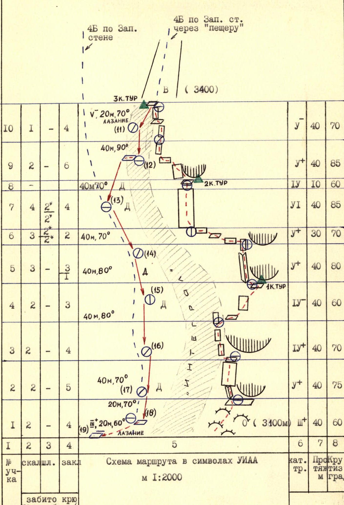
The first ascent along the Western wall of the proposed route is the passage of the right route 4B cat. diff. through the "cave", the essence of which is the choice of the most logical and simple path to the right of the so-called "black vein" in the form of an integral with a control point in the niche (2nd control point), conditionally called the cave. The most complex part of this ascent is the section from the 1st control point to the newly established 3rd control point to indicate the descent point. The route begins 15-20 m to the right of the "vein". Along the "ram's foreheads" (section R0-R1) - exit to an inclined shelf under an overhanging wall. In the left part of the shelf - along the crevice, ascent up-left 7-10 m (section R1-R2), then traverse 5-7 m and ascent vertically up to the arch under the "balcony" 20 m, exit to the balcony. From the "balcony" - move left 3 m to the "vein" and climb along it (section R2-R3, 40 m). Destroyed rocks.
Section R3-R4 - transition from the "vein" to the right-up to the wall and ascent diagonally to the right-up at an angle of 30-40° (35 m) to a shelf under a black cornice (1st control point).
From the control point on the section R4-R5, bypassing the black cornice on the left, ascent:
- first along the crevice (20 m);
- then through an overhanging chimney (7 m);
- along a smooth plate with a crevice (13 m);
- exit to a red triangular ledge.
From the ledge (section R5-R6) - traverse left 10 m along a smooth plate, then with an ascent at an angle of 20-30° to the left along shelves with walls (20 m), exit to a green arch under a sheer plate with bolts. Using 2 bolted hooks on the ITO, along a smooth plate - traverse left (7 m) into the inner corner. Difficult. Here organize a station for further movement up the sheer wall.
Section R6-R7 is key on the route. It is a not very pronounced sheer gully-wall with crevices and inner corners (40 m). The rocks are smoothed, the holds are rounded, facing down. For insurance, 2 bolted hooks are hammered in on the section.
Along the inclined plates of section R7-R8 (10 m) - exit to a niche (conditionally "cave") with a 2nd control point. From here, ascent along the left sheer plate or overhanging inner corner (the largest placement elements are used) - 15 m, and then ascent with a traverse to the left (20-25 m, section R8-R9). Rocks are destroyed.
Further up (section R9-R10) along the destroyed rocks of black rock (upper part of the "vein") - exit to the wall bend (35-40 m). Here, under a 2-meter sheer last wall - control point №3, fixing the end of the ascent along the wall. From here the descent begins.
Descent first along the ascent path 20 m by climbing with a deviation to the left. The first rappel (42 m) and the station must be organized so as to get to the site on the black "vein" (which must be crossed). (Section R11-R12). Here a large (up to 2 m from the wall) overhang.
Then traverse 10 m along the shelf.
The next descent (section R12-R13) must be performed diagonally to the left for safety reasons from possible falling stones. After this descent is completed by all participants, the next descent can begin.
Descent on sections R13-R18:
- oriented to the right from the line of water flow;
- parallel work of all participants on several stations is possible;
- all stations, by agreement with the educational department, are left for possible emergency descent.
On section R18-R19, descent by climbing along not very complex rocks.
Further transition about 40 m to the next route - along the crevice of the Western wall. First along simple rocks 30 m to a shelf under a cornice closing the crevice. The cornice is bypassed on the left along a smooth plate (section R20-R21) in an arc (left-up-right). This is a key section of the route, leading to the crevice (a powerful inner corner passing through the entire wall).
After 100 m (section R21-R22) - a niche with a 1st control point. From here, two path options are possible:
- straight up - a more difficult option;
- first traverse left 5-7 m, then up (section R23-R25) to the juniper.
The juniper is located on a shelf under a sheer wall. The wall is passed on the left: first along the inner corner (5 m), then traverse to the right and along the inner corner - exit under a smooth red plate.
On section R26-R27 - movement diagonally to the left behind the corner of the wall, then traverse under an overhanging wet inner corner (section R27-R28), after which a chimney and a series of inner corners lead to the plates of the left slope of the ridge and to the ridge itself.
Along the ridge 25-30 minutes to the summit. Descent from the summit along the route 1B cat. diff. to the Kulay-Dzhavaлон glacier and further to the base camp on the "Green Glade".
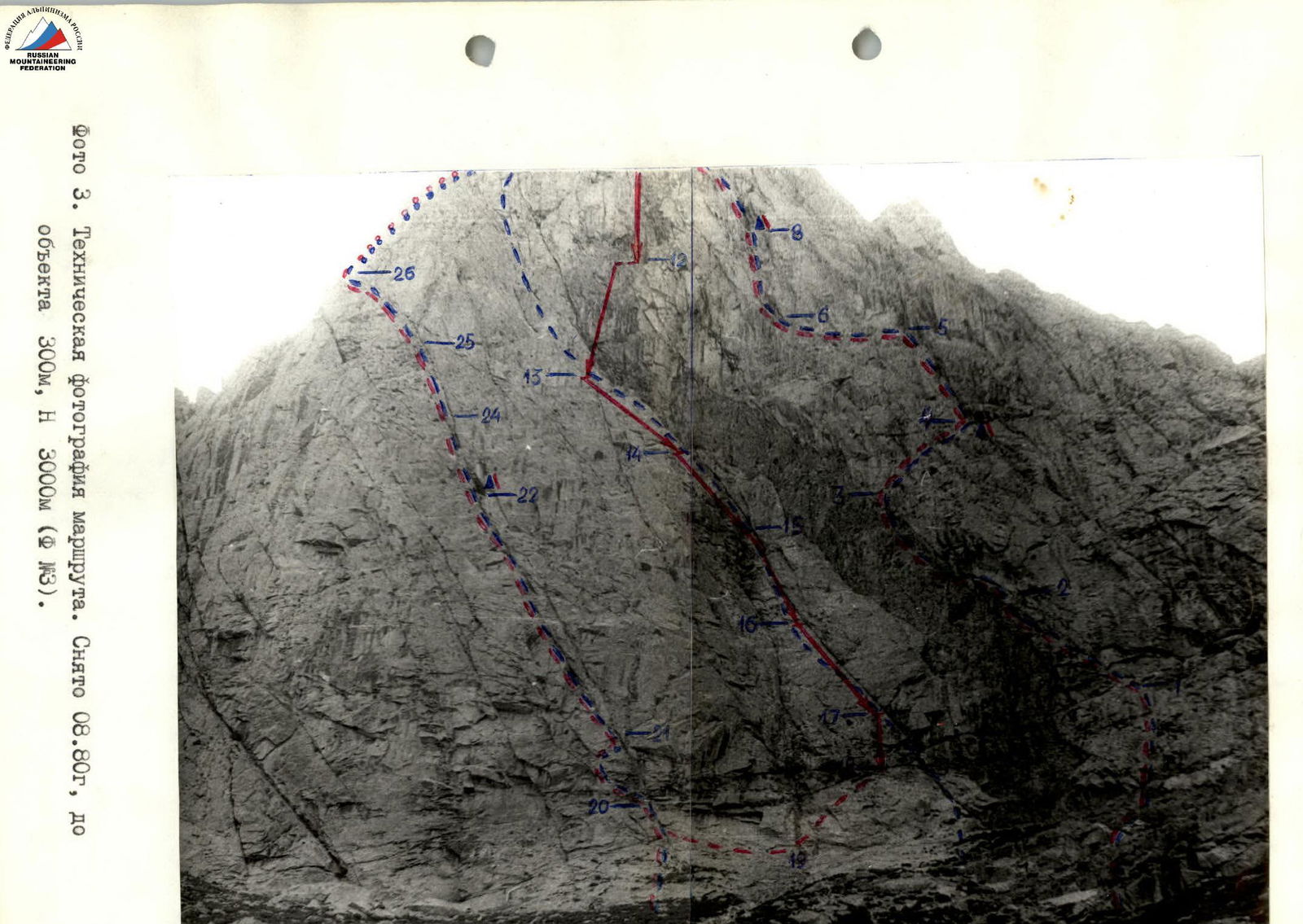
Photo 3. Technical photograph of the route. Taken 08.80, distance to the object 300 m, H 3000 m (F №3).