Ascent Passport
- Ascent type — rock climbing.
- Ascent area — Igizaki, Gissar Ridge.
- Peak — Bivachnaya (north) — 3800 m, via the cleft on the Western wall.
- Proposed difficulty category — 4B
- Route characteristics: height difference — 600 m, length of sections with 5–6 difficulty grade — 60–70 m, average steepness of the wall section — 65°
- Pitons driven: rock pitons for protection — 53, for artificial holds — 9, "zakladukhi" for protection — 3, for artificial holds — 2.
- Number of climbing hours: approach from "Zelyonaya Polyana" bivouac — 1 h ascent to the summit — 9 h descent from the summit to "Zelyonaya Polyana" bivouac — 1 h 30 min.
- Possible overnight locations:
- in a "niche",
- shelf near the "rusty slab",
- on the ridge.
- Ascent made by a duo of instructors: Igolkin V. I. — 1st sports category, certificate No. 1569 Shatalov V. A. — 1st sports category, certificate No. 1894
- Departure to bivouac — route from "Zelyonaya Polyana" bivouac on July 30, 1979. Return to bivouac on the same day.
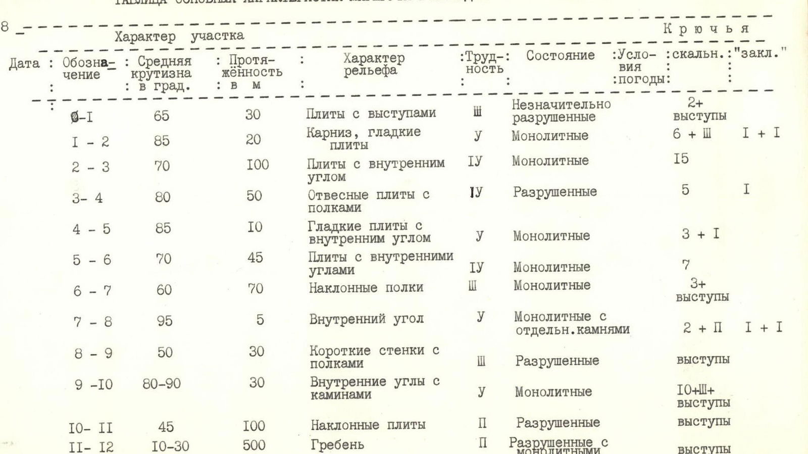
Table of main characteristics of the ascent route to peak Bivachnaya
| Designation | Average steepness in ° | Length in m | Terrain characteristics | Difficulty | Condition | Weather conditions | Pitons driven: rock | "zakladukhi" |
|---|---|---|---|---|---|---|---|---|
| R0–R1 | 65 | 30 | Slabs with protrusions | 3 | Slightly destroyed | 2+protrusions | ||
| R1–R2 | 85 | 20 | Cornice, smooth slabs | 5 | Monolithic | 6+3 | 1+1 | |
| R2–R3 | 70 | 100 | Slabs with internal angle | 4 | Monolithic | 15 | ||
| R3–R4 | 80 | 50 | Steep slabs with ledges | 4 | Destroyed | 5 | 1 | |
| R4–R5 | 85 | 10 | Smooth slabs with internal angle | 5 | Monolithic | 3+1 | ||
| R5–R6 | 70 | 45 | Slabs with internal angles | 4 | Monolithic | 7 | ||
| R6–R7 | 60 | 70 | Inclined ledges | 3 | Monolithic | 3+protrusions | ||
| R7–R8 | 95 | 5 | Internal angle | 5 | Monolithic with separate rocks | 2+2 | 1+1 | |
| R8–R9 | 50 | 30 | Short walls with ledges | 3 | Destroyed | protrusions | ||
| R9–R10 | 80–90 | 30 | Internal angles with chimneys | 5 | Monolithic | 10+3+protrusions | ||
| R10–R11 | 45 | 100 | Inclined slabs | 2 | Destroyed | protrusions | ||
| R11–R12 | 10–30 | 500 | Ridge | 2 | Destroyed with monolithic parts | protrusions |
Description of the route to peak Bivachnaya via the cleft on the Western wall, 4B category.
From "Zelyonaya Polyana" bivouac, move along moraines and grassy slopes initially towards peak Mal. Igizak — 500 m, and then towards Bol. Igizak pass along the left talus slopes descending from the ridge of peak Bivachnaya. Approach the Western monolithic wall of peak Bivachnaya (1 h).
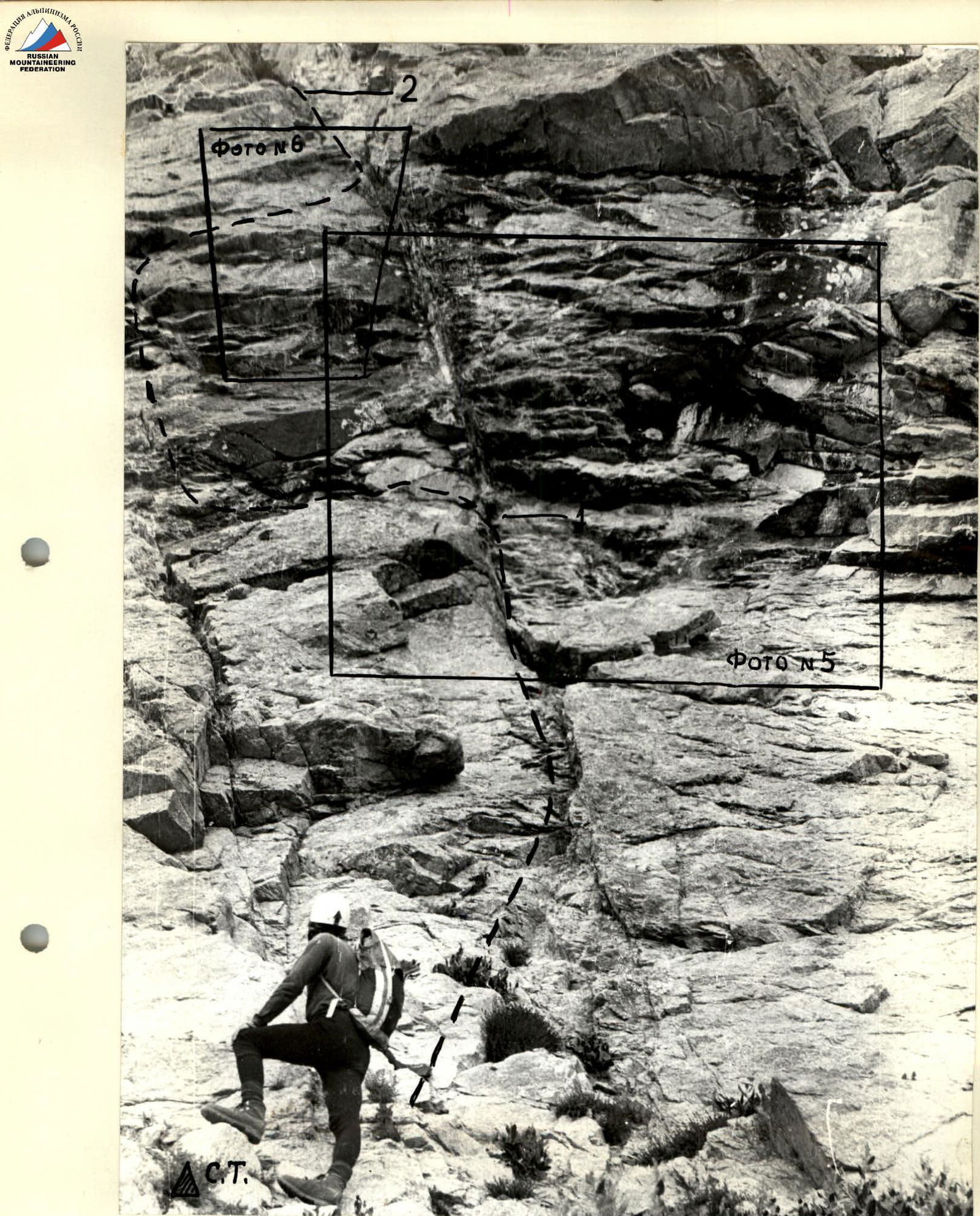
The route begins to the left (100 m) of the "black rock vein" that passes through the Western wall in its right part from horizontal talus ledges (on which there is a signal cairn).
The cleft:
- passes through the entire Western wall with a leftward inclination,
- is located almost parallel to the aforementioned vein (at a distance of 100 m from it),
- is clearly visible on the approaches to the route.
The exit to the cleft, which begins 45–50 m from the ledge (start of the route), is made:
- first along moderately difficult slabs — 30 m,
- then through a cornice and highly smoothed steep slabs, which are climbed using artificial holds — 20 m (difficult, first crucial section).
Further, the route proceeds very logically, always through the cleft.
In the upper part, the wall and cleft are oriented northwest. The exit to the Western ridge is made along its northern plane. Further along the ridge — through moderately difficult rocks — to the summit. Descent via a 1B category route or to the start of the route.
The route is classified as 4B category, includes sections of 5th category, and is recommended for well-prepared sports groups.
R0–R1. From the signal cairn located on the talus ledge under the start of the route, climb moderately difficult rocks to a horizontal ledge under the cornice 25–30 m.
Section R1–R2. The cornice is passed using artificial holds to the left of the crack that leads to the cleft. The crack is filled with rock debris. Having climbed 6–7 m through the cornice onto smooth slabs, move rightwards to the crack and along it 10 m to exit into the cleft.
Section R2–R3. At its beginning, the cleft is a large internal angle with an overhanging right plane and a monolithic left plane with cracks for pitons, along which one must climb. Protection is via pitons. Length of the section is 100 m. The internal angle leads to a rock "niche". Here is the first control cairn.
Section R3–R4
- From the "niche", the cleft continues as a steep wall 8–10 m and turns left.
- Under the wall — a ledge with destroyed rock.
- The wall itself has no cracks suitable for piton placement, so it's better to traverse left 10–15 m from the "niche" and climb along narrow ledges leading left-upwards 20–25 m.
- The wall overhangs the ledges, and under them, the wall is steep (up to the start of the route).
- The section is "psychologically challenging".
- Then climb upwards along the steep wall, sometimes with overhangs and ledges with "live" rocks — 20 m.
- In the upper part of the section, one can deviate somewhat to the right.
- You exit onto ledges with fine talus and "live" rocks, continuing the cleft.
- On the ledge, there is a juniper bush — one of the route's landmarks, visible through binoculars from the moraine before the wall.
Total length of the section is 50–60 m.
Section R4–R5
- From the juniper bush, move along a horizontal ledge 10 m to the cleft, which goes upwards-left 5 m.
- Here, there are few cracks for pitons, rocks are smoothed, rounded, with overhangs.
- From the ledge, first climb the cleft 5 m using artificial holds, and then rightwards along smooth (on friction) steep slabs 5 m — to a small ledge.
Section R5–R6
- From the ledge, climb a series of steep walls formed by smoothed slabs with separate protrusions, vertically upwards.
- Further, a wide crack formed by a powerful separate slab and wall — 7 m — leads to a wide ledge (2nd control cairn), located under a steep smooth rusty slab (is a route landmark and visible from the approaches to the route, is in the second half of the wall).
- From the cairn to the slab — 10 m.
Total length of the section is 45 m.
Section R6–R7
- From the 2nd control cairn, climb the cleft, which here turns into ledges with varying angles of inclination.
- Here, the cleft turns left onto the northwest wall.
- There are good protrusions for organizing protection.
- Rocks are monolithic.
- At the end of the section, 30 m below, there is a wide green ledge visible from the talus under the route (route landmark).
Section R7–R8
- The cleft leads to an overhanging, wet, 5 m chimney with an internal angle.
- It is overcome using artificial holds.
- Hexagonal "zakladukhi" fit well.
Section R8–R9
- The chimney leads to a series of ledges with walls containing "live" rocks, along which one must move cautiously.
- Protection is through protrusions.
- Direction of movement — upwards-left.
Length of the section is 30 m.
Section R9–R10
- The section consists of steep slabs and internal angles formed by these slabs.
- Movement is vertically upwards, climbing is difficult, artificial holds are required.
- Internal angles lead to a steep 10-meter chimney with smooth walls, 0.4–0.6 m wide.
- Passed using chimney technique.
- Upon exiting the chimney, there's an inclined cleft leading right 7 m to a horizontal ledge before a smooth steep 3-meter wall.
- The wall is climbed with assistance.
Total length of the section is 30 m.
Section R10–R11
- The 3-meter wall leads to inclined slabs, along which one moves upwards and rightwards onto a col in the ridge.
- The col is a key point of this route, as well as routes 3B and 4B.
Section R11–R12
- From the col, rightwards along a ledge, bypassing black rocks onto the southwest slopes.
- Along easy and moderate rocks of the ridge — to the summit.

View of the first half of the wall section of the first ascent route.