Ascent Passport
I. Ascent category — technically challenging.
-
Ascent area — Pamir-Alay, Gissar Ridge, Igizak area.
-
Ascent route — North ridge of Bivachnaya peak.
-
Ascent description: Height difference — 500 m Average slope — 35°–40° Length of complex section — 60 m Slope of complex section — 60°–75°
-
Pitons driven: Rock — 1 Ice — 0 Bolt — 0
-
Duration — 6 hours
-
Number and description of bivouacs —
-
Team name: CS DSO "Khosilot", Dushanbe.
-
Team members: SOLOVYEV M.A. — 1st category, leader SKRICITIL A.M. — CMS EIDUS S.N. — 2nd category
-
Team coach — SOGRIN S.N.
-
Date of departure and return — 27.06.1976
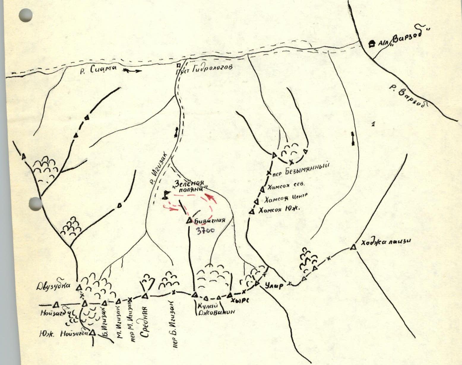
Map of Igizak area.
Brief geographical description of the area
Bivachnaya peak is located in the Igizak area — the closest and most accessible climbing area in the Gissar Ridge. It is located near the roads and "Varzob" mountaineering camp.
The area is situated in a lower spur of the Gissar Ridge, branching off from the main ridge, dividing the upper reaches of the Kadam-Tash and Siama rivers and then turning east. In the latitudinal direction, the spur has a rather large extent. The eastern end of this spur breaks off to the Varzob gorge. In the eastern part of the ridge is the Igizak area with the eponymous gorge, flowing into the Siama.
Routes to Bivachnaya peak, as well as to neighboring peaks, are rocky due to the small glaciation of the area.
The ascent is most conveniently done from the "Green Glade" bivouac, located directly below Bivachnaya peak. The approach to the bivouac is made from the "Varzob" mountaineering camp along the trail on the left bank of the Siama River to the Igizak gorge. Along the left (in the direction of travel) side of the gorge, ascend to the "Green Glade" bivouac. The approach takes up to 3–5 hours.
The relief of the area is alpine, with sharp rugged slopes. Relative elevations of watersheds above the river valleys of the second order are 500–600 m. Absolute heights of peaks are around 4000 m above sea level.
The climate of the area is sharply continental, with long, stable periods of good weather in the summer. Winters are quite snowy, which, combined with the relief, leads to frequent avalanches in the spring (especially in April).
Route description
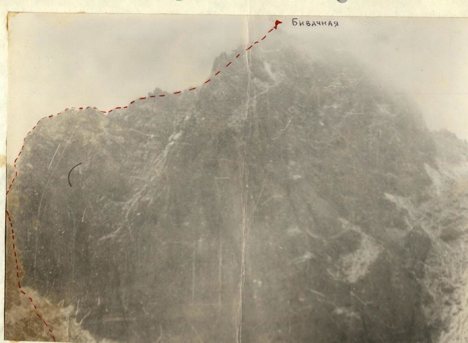
From the "Green Glade" bivouac, go up the trail towards Bolshoy Igizak peak for about 30 minutes under the slopes of Bivachnaya peak to its northeastern wall. Then, along the large scree, approach the wall and, to the left along it, move to the slopes of the north ridge of the peak.
The northwestern wall of the peak, its north ridge, and the buttress descending from the ridge to the west form a peculiar small cirque, oriented with its open side to the west. The start of the route is located in the left, far corner of the cirque.
The route begins with a rock wall of average steepness with rich microrelief. There are ledges. Length 60 m. Then the wall turns into an internal corner of the same steepness, 80 m long. Movement is simultaneous and alternating (belay through ledges, sometimes piton). Total length of the section is 140 m. The internal corner turns into a fairly gentle grassy couloir, at the beginning of which stands a cairn. 120 m of simultaneous movement from the cairn lead to a short rock wall, going up to the right from the couloir. The wall is short but quite steep (more than 65°). Then, along a slab with a steepness of 50°, 15 m, approach a ledge that goes to the right for 10 m. The next ledge goes 20 m to the left. Along it, approach a fairly smooth internal corner, leading out to the ridge.
Movement is alternating. Belay through ledges, possibly piton. Then, along the ridge, bypassing the encountered gendarmes to the right, 300 m of simultaneous movement lead to the summit.
Descent from the summit to the southeast is done along the classified 1B category route.