Ascent Log
-
Ascent type — rock climbing
-
Ascent area — Sang-Hok, Hissar Range
-
Peak, elevation, ascent route — XXX years of "Varzob" 4367 m, via the center of the western bastion.
-
Difficulty category — 5A (estimated)
-
Route characteristics:
Elevation gain — 750 m. Average steepness of the wall section — 75°. Route length — 1000 m.
-
Pitons placed:
for belay for ETAs rock 32 ice 1 bolt — protection 26
-
Time taken from base camp to summit — 13 hours. One overnight stay.
-
Surname and initials of the leader and participants, and their qualification:
Smirnov M.B. — Master of Sports, leader Bridsky M.A. (Candidate for Master of Sports)
-
Team coach — Kapitanov O.B.
-
Date of departure for the route — 29.06.1983 Date of return — 30.06.1983
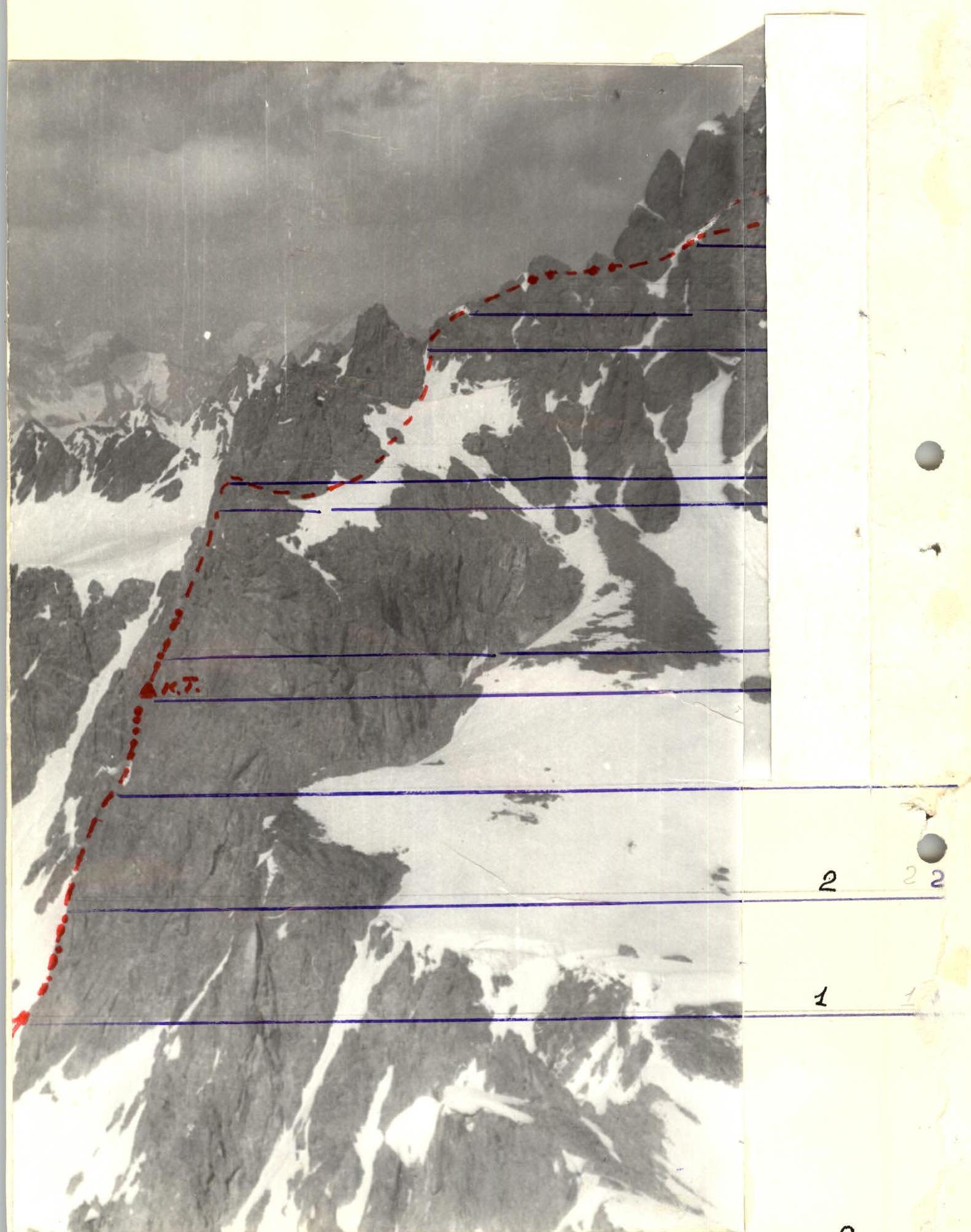
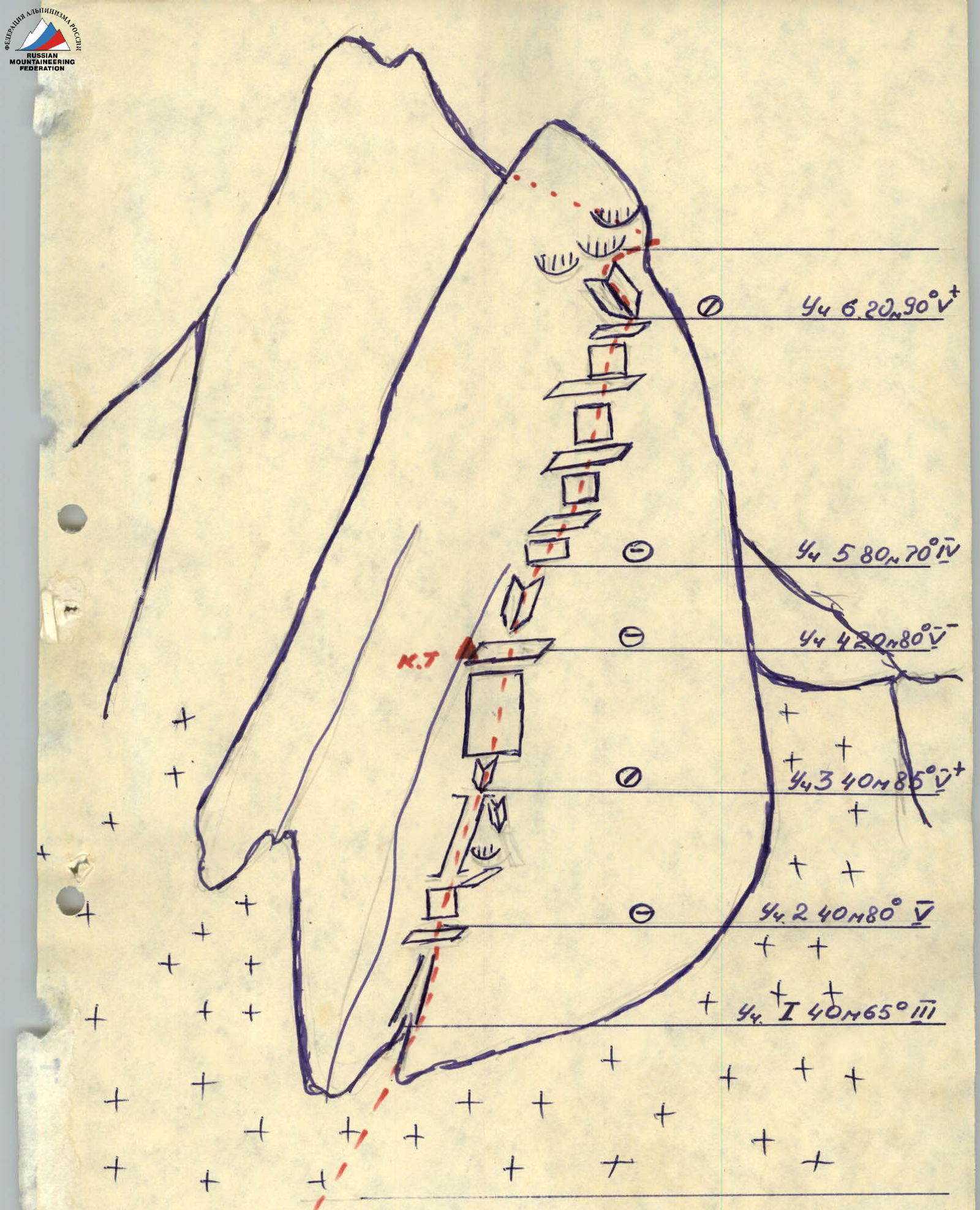
Schematic of the wall section of the route in UIAA symbols on peak XXX years of "Varzob"
Table
Main characteristics of the ascent route to peak XXX years of "Varzob" via the center of the western bastion, 5A category of difficulty (estimated) (first ascent)
| Date | Designation | Average steepness | Length in m | Terrain characteristics | Difficulty | Condition | Weather conditions | Rock | Protection | Bolt | Ice |
|---|---|---|---|---|---|---|---|---|---|---|---|
| 29.06.1983 г. | R0–R1 | 45° | 140 | snowy slope with a bergschrund | hard firn | good | – | – | – | – | |
| R1–R2 | 65° | 40 | destroyed ridge | III | destroyed with loose rocks | –"– | 1 | 1 | – | – | |
| R2–R3 | 80° | 40 | wall turning into a chimney | V | monolith | –"– | 6 | 2 | – | – | |
| R3–R4 | 85° | 40 | inner corner, transition to wall | V+ | monolith, few cracks | –"– | 6 | 3 | – | – | |
| R4–R5 | 80° | 20 | inner corner | V– | monolith | –"– | 1 | 2 | – | – | |
| R5–R6 | 70° | 80 | ledges, walls | IV | many loose rocks | –"– | 4 | 3 | – | – | |
| R6–R7 | 90° | 20 | inner corner, transition to overhanging wall | V+ | monolith | –"– | 2 | 3 | – | – | |
| R7–R8 | 55° | 60 | inclined ledges with walls | III | many loose rocks | –"– | 3 | 5 | – | – | |
| R8–R9 | 30° | 140 | snowy slope, transition to couloir | wet | –"– | – | 2 | – | – | ||
| R9–R10 | 20° | 90 | ridge | II | monolith | –"– | – | 2 | – | – | |
| R10–R11 | – | 30 | snowy saddle | hard | –"– | – | – | – | – | ||
| R11–R12 | – | 40 | ledge | II | monolith | –"– | – | 2 | – | – | |
| R12–R13 | – | 20 | snowy saddle with a cornice | hard | –"– | – | – | – | – | ||
| 30.06.1983 г. | R17–R18 | 40° | 40 | couloir slope | III | destroyed | –"– | 2 | – | – | – |
| R18–R19 | 35° | 80 | snowy slope | hard firn | –"– | – | 1 | – | – | ||
| R19–R20 | 55° | 60 | wall | III | destroyed, many loose rocks | –"– | 2 | 1 | – | – | |
| R20–R21 | 80° | 10 | wall | IV | monolith | –"– | – | 1 | – | – | |
| R21–R22 | 50° | 130 | ridge | III | destroyed | –"– | – | 1 | – | – |
Departure for the route at 10:00. Stop for a bivouac at 20:00. 10 hours of walking. Bivouac conditions good (lying down, water available).
Departure from base camp — 8:30. Departure for the route — 10:00. Stop for the night — 20:00. Departure from the bivouac — 8:30. At the summit — 10:30. Return to base camp — 14:00.
Brief Description
of the approach and route to peak XXX years of "Varzob" 4367 m via the center of the western bastion, 5A category of difficulty (estimated). (First ascent)
From the base camp, located under the slopes of the 40 years of Komsomol of Tajikistan massif, move first across grassy slopes and moraines and then across the closed glacier in the direction of the western bastion of the peak, clearly visible from the camp. From the base camp, it takes 1 hour.
Section R0–R1. Move up the snowy slope through a simple bergschrund in the direction of a small couloir at the bottom of the bastion, about 150 m. The slope steepness before reaching the rocks reaches 50°.
Section R1–R2. Via a destroyed rock ridge to the left of the couloir, reach a ledge under the wall. There are many loose rocks on the ridge, but the climbing is not difficult.
Section R2–R3. It is a wall turning into a chimney, with some small overhangs. The most challenging part is the entrance to the chimney.
Section R3–R4. The key section of the route. It is better for the first climber to pass it in galoshes and without a backpack. The wall is monolithic with smooth holds. The rocks are occasionally wet from dripping water, and there may be ice in the morning hours. There are few places to hammer in pitons; small protection elements are needed. The wall ends with a wide ledge, convenient for organizing a belay. To the left on the ledge, there is a control cairn.
Section R4–R5. A monolithic wide inner corner with almost vertical walls. The terrain is blocky. The inner corner leads to a flattening part of the bastion.
Section R5–R6. This section is a wall with many ledges. There are many loose rocks on the ledges. The structure is blocky. Movement is simultaneous with careful piton belay.
Section R6–R7. An inner corner inclined to the right and left with an overhanging right face. Inside the corner, there is a wide, about 30 cm, crack. The inner corner ends with a wall overhanging the upper part of the inner corner. At the top of the wall, there are loose overhanging rock formations. Caution! The overhang is passed using ETAs.
Section R7–R8. Move right and up across simple rocks towards the snowy slope on the right side of the western ridge leading to the summit. Movement is across inclined ledges with piton belay.
Section R8–R9. A snowy slope with a steepness of up to 40° in the upper part turns into a couloir, leading to the ridge behind the first tower. Belay can be organized through an ice axe or pitons hammered into the rocks to the left.
Sections R9–R13. A gentle ridge. Monolithic. Two snowy saddles with cornices to the left. Belay through outcrops. Simultaneous movement is possible. Caution is needed when passing cornices.
Section R13–R14. This section begins the bypass of a large pre-summit tower, which starts from the ridge with a 70-meter wall about 75° with smooth rocks and ice in many places. Bypassing this tower to the right is technically simpler. The bypass starts with a simple wall that turns into a ledge, resting against a snowy slope.
Sections R14–R16. Begins with a traverse across a snowy slope, which leads to the shoulder of one of the ridge spurs. The slope at the end of the rope (last 2–3 meters) approaches 90°. Belay on the first 10–20 meters is целесообразно to organize through pitons hammered into the rocks to the left. From the shoulder, along an inclined ledge strewn with rocks, 40 m to approach a groove filled with ice.
Section R16–R17. It is a groove filled with ice, with a steep wall leading to the shoulder of the next spur. On the shoulder, there is a convenient and safe place for a bivouac. From the shoulder, the summit is visible.
Section R17–R18. Across destroyed rocks of the upper part of the couloir (many loose rocks) reach the snowy slope under the wall of the pre-summit tower.
Sections R18–R21. Across the snowy slope at 35° move about 80 meters towards the destroyed wall under the saddle between the summit and the pre-summit tower. Movement is simultaneous. On the steep snowy section, belay can be well organized through an ice axe.
Section R20–R21. A ten-meter wall with a steepness of about 80° leads to a saddle on the ridge. The wall is monolithic.
Section R21–R22. A ridge leading to the summit. Movement is simultaneous. The length of the section is about 130 meters. Belay is mostly through outcrops.
Descent from the summit:
- First, 30 meters along the ridge to the south.
- Then, across a not very distinct spur, down to the east 100–150 meters across destroyed rocks of 2–3 category of difficulty to a snowy-ice couloir leading to the glacier descending into the Lailak-Kul valley.
- The glacier is closed with many crevasses.
- Then — to the Sang-Hok pass and back to the base camp.
Descent takes 3.5–4 hours.
The route is combined, logical, characterized by diverse technical work, and requires the ability to navigate the route. It is recommended for camping and sports groups.