
Ascent Passport
I. Ascent category — traverse 2. Ascent area — Pamir-Alay, Alay Range 3. Ascent route — traverse of Alay Range from
- peak 5529 m to peak Tamdykul with passage of
- peak 5529 m (peak "30 Years of Victory"), ascent via eastern wall, first ascent,
- peak 5300 m (peak "Pyramida"), first ascent,
- peak 5308 m, first ascent,
- peak 5380 m (peak "Zaщitnikov Leningrada"), first ascent,
- peak 5200 m, first ascent,
- peak 5080 m,
- peak 4850 m,
- peak Tamdykul 5539 m, descent to Archa-Bashi glacier, first ascent, via Tamdykul glacier. (names in brackets are given by the team)
- Length of sections by difficulty:
- 3rd cat. diff. — 2550 m
- 4th cat. diff. — 242 m
- 5th cat. diff. — 9875 m
- 6th cat. diff. — 610 m
Total route length — 15.5 km. Total height difference — 5.5 km.
- Pitons driven: rock — 394, ice — 102, wooden wedges — 5
- Total walking hours — 130
- Number of nights on traverse — 11
- Team name — LenGorsportkomitet team from Leningrad.
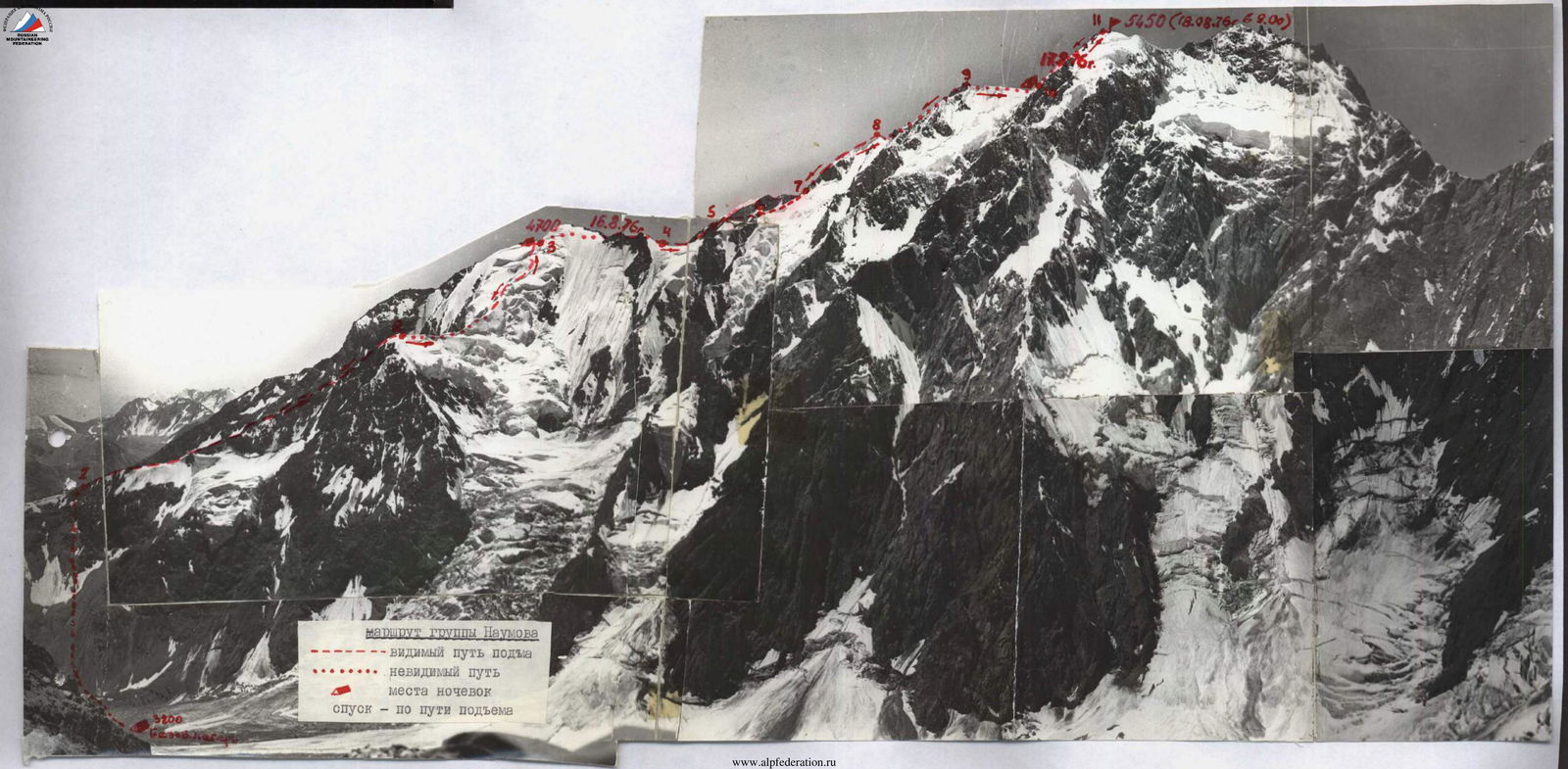
TABLE:
- Name and qualification of team captain and members
Captain — ZAKHOZHII Mikhail Mikhailovich, Master of Sports of the USSR Members:
- BAKUROV Vyacheslav Anatolyevich, Master of Sports of the USSR
- MARKOV Dmitry Prokofyevich, Master of Sports of the USSR
- IVASHEV Vadim Kornilovich, Master of Sports of the USSR
- KRAPIVIN Valentin Nikolayevich, Candidate Master of Sports
- CHEREPOV Vladimir Alekseyevich, Candidate Master of Sports
-
Senior team coach — PULINETS Yury Semyonovich, Master of Sports of the USSR Team coach — MARKOV Dmitry Prokofyevich, Master of Sports of the USSR
-
Dates of departure and return to base camp — July 1 — July 14, 1975
I. Brief geographical description of the ascent area
1. Topography of the area
The peaks chosen for the traverse are located in the southwestern part of the Alay Range. This small mountain country is bounded: to the south by the Alay Valley, to the east by the eastern part of the Alay Range, to the north by the eastern spurs of the Matcha mountain node and the foothills of the eastern Alay, and to the west by the Matcha mountain node, where the Turkestan and Zeravshan Ranges meet.
The mountains of the Tamdykul area are of the Alpine type. With sharp and pointed outlines, they remain above 4500–5000 m over a significant extent. Only a few peaks, such as peak 5529 m, are powerful ridge-type massifs with significant glaciation. The snow line is located at a height of about 3800 m on the northern slopes and is slightly higher on the southern slopes.
From an alpinist's perspective, this mountain area is completely unexplored and is a true "white spot." The same can be said about the naming of the peaks. As was found out from local residents, only some of the most characteristic peaks have names. One such peak is Tamdykul:
- In Kyrgyz: "Tamdy" — house, hut made of stones;
- "kul" — lake;
- "Tamdykul" — "house by the lake." The remaining peaks in the part of the Alay Range traversed do not have local names. On maps, these peaks have only geodetic marks. All names of peaks and summits given in this report, except for Tamdykul, do not have official names and were given by the expedition participants due to being the first to ascend them.
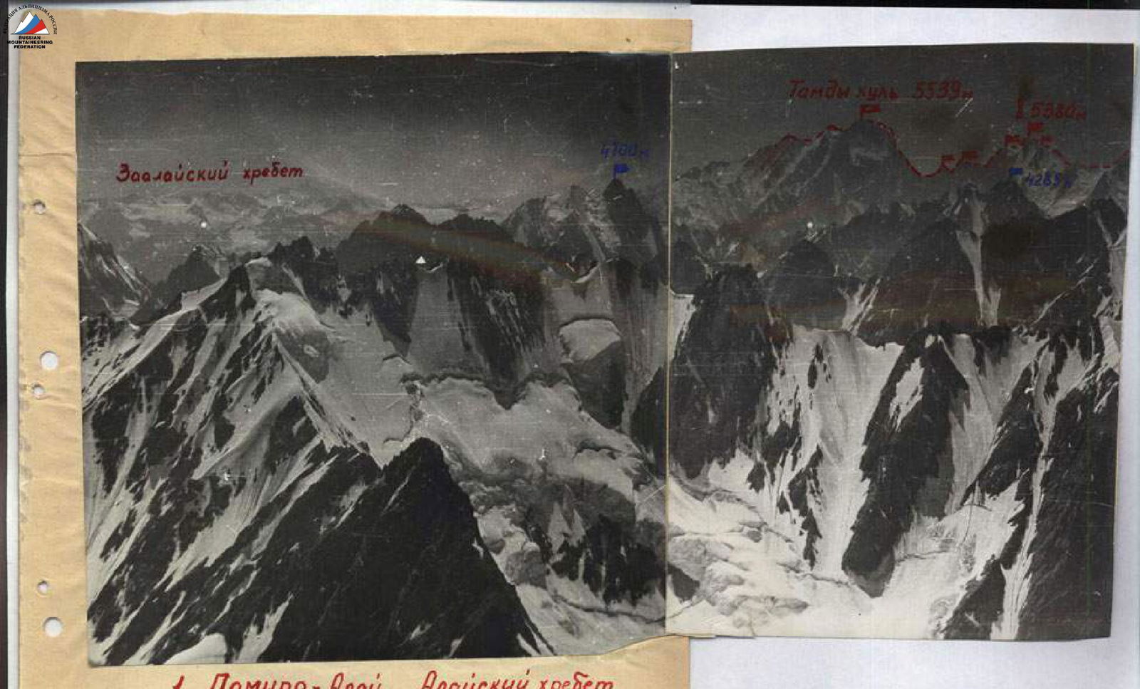
- Pamir-Alay. Alay Range. Area of peaks 5529 and Tamdykul 5539 m. View from the east.
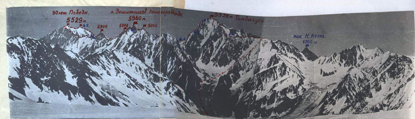
Area of peaks 5529 and Tamdykul 5539 m. View from the west.
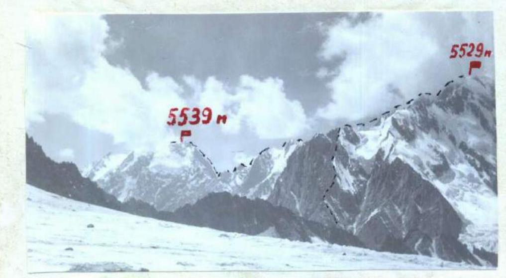
View from the northeast. A request to assign these names to the peaks will be sent to the relevant organizations.
- The mountains in this area are composed primarily of siliceous and clay shales, sandstones, and limestones. Marble, granite, and calcite are also found. Due to the combination of rocks with such different strengths and the sharply continental climate, the rocks are heavily destroyed — even the northern walls are extremely rockfall-prone. Valley glaciers are heavily littered with rock debris, and traversing icefalls is greatly complicated by constantly falling stones from the seracs.
- The climate of the area is moderately continental, and in the foothills, it is moderately warm. The average annual duration of sunshine is 2500–2600 hours (in Moscow, it is about 1600 hours). Summers are hot but not sultry. Winters in the mountains are cold, with frosts and strong winds blowing predominantly from west to east. The weather is stable only in the second half of summer, approximately from July 15–20. In May and June, the weather changes sharply. Thunderstorms, snowfalls, and strong winds are common. However, bad weather does not last long, typically 5–7 days, followed by sunny but windy weather. During our stay, we observed three instances of sharp weather deterioration, and unfortunately, one of them caught us on the route.
4. Access routes and approaches to the base camp
From Fergana to the large village of Soh, there is a paved highway about 120 km long, and from Soh to the village of Kan, there is a dirt road about 45 km long, and further to the transshipment salt base, about 10 km.
The last shop is in the village of Kan, and the post office is in the village of Soh. All villages in the upper reaches of the Soh River are united into a collective farm, the headquarters of which is located in Batken.
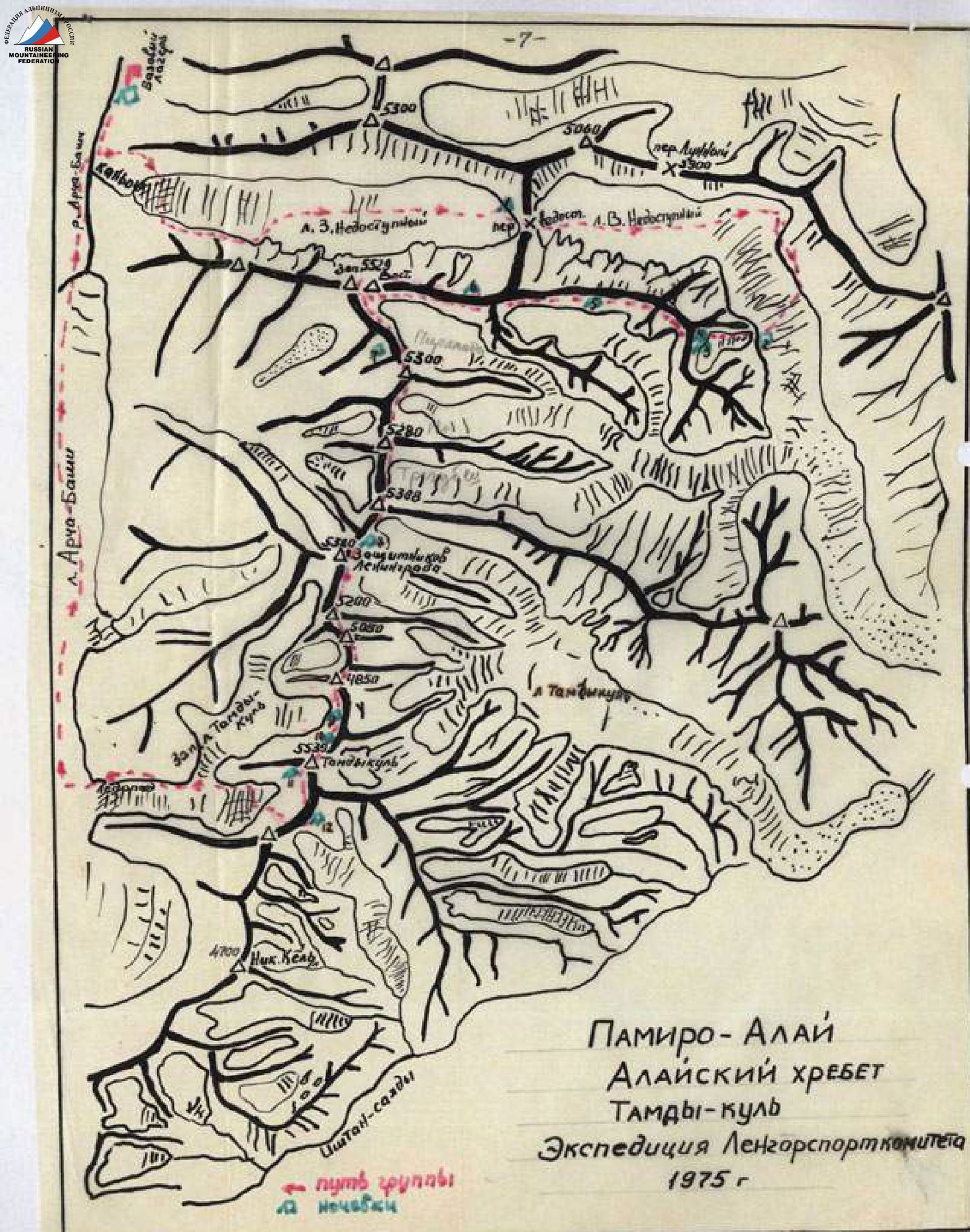
From the transshipment base (salt warehouse for sheep), where the dirt road ends, a trail winds through the canyon of the Soh River to the village of Zardale — 12 km. The trail is narrow, sometimes cut into the rocks, and occasionally there are avringi. From Zardale, the trail goes to the east-southeast, crosses a small hill with burial grounds, descends to a bridge over the Ak-Terek River, and after the bridge, it rises to the abandoned village of Kurgan. From the village of Kurgan, the trail gently goes in a southeast direction and further deviates to the south towards the Archa-Bashi glacier to the abandoned village of Shudman (15 km from Zardale). Another 6 km along a barely visible trail, traversing the slope along the left (orographically) bank of the river, leads to hot hydrogen sulfide springs. The water with a temperature of 45° flows down the slope in a waterfall and flows from one bath to another. Opposite the springs, there is a snow bridge that can be used to cross to the opposite right bank of the Archa-Bashi glacier gorge. Our base camp was located here on a narrow green slope with limited firewood.
A significant portion of the expedition's cargo was transported to the base camp on donkeys, which were quite difficult to obtain at that time. In late June, mass livestock migration begins, and all donkeys are busy transporting the property of shepherds. Still, a considerable amount of cargo had to be carried on our backs. Each participant made 2–3 trips with a load.
Description of the route passage
July 1, 1975
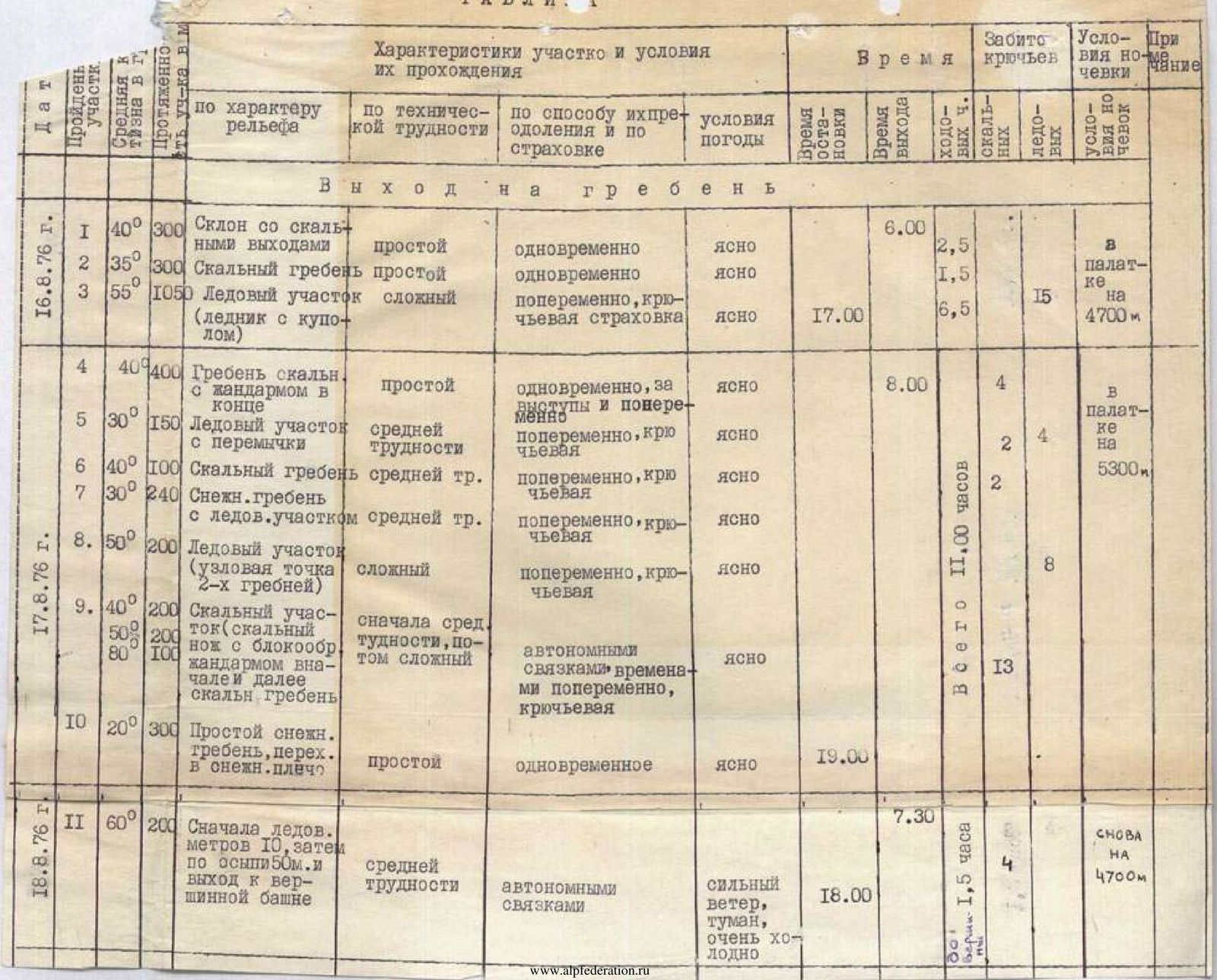
Approach. From the base camp in the Archa-Bashi valley near the hot springs, we can follow the trail along the right bank of the river to the canyon of the West Nepristupny glacier. The canyon is very complex and dangerous to traverse. Steep rock walls, "ram's foreheads," a turbulent river flowing from the glacier, constant rockfalls, and icefalls blocking the width of the entire canyon — these are just a few of the difficulties that stand in the way. Therefore, during reconnaissance trips to the Nepristupny pass, we had to look for a different path to the West Nepristupny glacier. Such a path was found. It turned out to be a bit longer but much less complicated and practically safe. Not reaching 200–250 m to the canyon, an osypnoy slope goes up, turning into a couloir. After 3–3.5 hours of ascent, we find ourselves in a small cirque surrounded by rock walls. Up 40 m via a chimney or wall to the left of it, using ropes, and after a short traverse, we reach the right side of the canyon, slightly above the glacier tongue. Traversing destroyed rocks and scree, we approach the icefall. Here, we need to find passages in the icefall and cross to the left (orographically) side of the glacier, which is simpler (1.5–2 hours). Then, 4–5 hours along the closed glacier, initially following the left side and then the middle of the glacier, we reach the Nepristupny pass. This pass on the east is cut off by a steep 150-meter snow-ice slope with islands of destroyed rocks. We stop for the night on the pass. To the right, a majestic view opens up to one of the main peaks of our traverse — peak 5529 m, which, after our ascent, we will name peak "30 Years of Victory" in honor of the first ascenders.
July 2, 1975
The tents are standing on the Nepristupny pass in tandem. The morning is clear. The air is crystal clear. It's cold. Water collected yesterday from thawing icicles has frozen through. We rise at 8:00. Shoulders ache a bit. Yesterday was a very difficult day: overloaded backpacks, 2000 m of ascent, 10 walking hours. The beginning of traverses is always difficult; you need to get into the rhythm.
We start descending from the pass at 10:00. Heavy backpacks and a steep, thawing snow slope of 45–50° make it difficult to move down. But soon all six team members are down on the East Nepristupny glacier. Farewell greetings are heard from the pass; our observers — led by V. ARANOVICH — remain there. Our path lies down to the eastern slopes of peak 5529 m — to three towers with mirror walls rising from the chaos of seracs of the East Nepristupny glacier icefall. Down the snowfields of the closed glacier, we descend for 2 hours to the icefalls. We try to find a passage between the wide and deep crevasses and the chaotic pileup of seracs but ultimately fail. The group moves to the left side of the glacier, crosses several destroyed rock ridges descending from the slopes of a nameless peak with a mark of 4500 m, and descends via a snow slope and couloirs to the lower, quite gentle part of the glacier, bypassing the icefalls from the left. On a small median moraine, we set up a bivouac. From here, we examine the beginning of our route, weighing all possible options and various situations that may arise during its passage.

Ascent (from the east) and traverse of peak 5529 m.
Our choice unanimously falls on the left, highest rock wall, to the lower part of which a steep rock ridge approaches, starting from the lower step of the glacier (3400 m). The ascent is logical, leading directly to the summit ridge, steep — 60–70°, and safe. MARKOV and IVASHEV went to scout and process the beginning of the route. ZAKHOZHII and CHEREPOV double-check the equipment, review the set and quantity of products, and distribute them among five backpacks. Tomorrow, the first participant will go with a lightened load. BAKUROV and KRAPIVIN are photographing the beginning of the route.
July 3, 1975
At night, it's cold and starry, but in the morning, the sky gradually becomes cloudy. 6:00. Duty officer IVASHEV prepares a "big" breakfast from products taken beyond the assault ration. At 7:00, everyone, wearing crampons and squatting on the way, leaves the bivouac and begins their journey. What will it be like for us? Passing under the wall between ice crevasses and seracs (R0–R1), marked with cairns, we exit under the ice slope (R2), which was processed the day before by the IVASHEV — MARKOV team. In crampons, along the ropes, we pass the ice slope and bergschrund. The ropes are icy. The self-locking knot and jammers are difficult to manage. On a small ledge under the rocks, we alternately remove crampons and overcome icy, destroyed rocks (R3) using ropes. It's necessary to move very carefully, as everything is "alive," and rockfall danger is very high. The processed sections ended. The IVASHEV — MARKOV team moves forward along the destroyed rock ridge with small walls (R4); they will work first today. The upper part of the ridge (R5–R6) is represented by two rock walls with a small bridge in the form of a horizontal rock ridge. Climbing is complex. Rocks have uncomfortable, sloping holds and few cracks for pitons. Mainly, vertical thick and channel pitons work well. The first climber ascends in galoshes using ladders. Water runs down the wall to the right — apparently, there's snow above us. Above the walls, there's a small snowfield turning into a 120-meter snow ridge (R7). The snow is deep. Insurance is through an ice axe. In the upper part, where the snow ridge approaches the strongly jagged, "feathery" rock ridge, its steepness increases significantly (50–60°). It's necessary to climb in three steps. Passing three ropes of the jagged ridge took us a lot of strength and time. Complex climbing, descents, and bypasses of "feathers," snow drifts with cornices in the saddles — that's how this section of the route can be characterized (R8). The pronounced ridge ended. Before us towered an 800-meter rock tower leading to the pre-summit ridge. Further advancement that day was pointless. We set up a bivouac on a small snow-ice plateau under a gendarme. The altimeter shows a height of 4000 m. The weather is warm, and the night passes calmly; we sleep like the dead, as the day was very tense. In 10 hours of work on the ice slope and ridge, we covered 515 m and 160 m along the ropes of the section processed the day before.
July 4, 1975
The weather worsened. Low clouds, wet snow 10–15 cm on the rocks. Visibility 20–30 m. The exit is postponed until the weather improves. At 11:00, during a brief clearing, the CHEREPOV — BAKUROV team heads out to scout and process the beginning of the wall. Climbing is very complex. In 4 hours, they manage to process only three ropes. The sheer rock wall (R9) ends with a small internal corner, precisely where it's most convenient to secure the end of the rope. Bivouac remains in the same place.
July 5, 1975
The weather is cloudy, with occasional snow grains falling, and wind. Exit at 8:00. The CHEREPOV — ZAKHOZHII team goes first. Today, they face a challenging task — icy ropes, steep, cold rocks dusted with snow. In such conditions, it's essential to be particularly attentive. The first rope processed yesterday turned out to be very difficult. We decide to pull up the backpacks. While the team pulls up the backpacks together, the CHEREPOV — ZAKHOZHII team passes an 80-meter rock tower (R10) on narrow ledges, where many small stones lie, dusted with snow. Above the tower, a snow-ice slope with embedded stones turns into a very steep (50–60°) snow-ice ridge (R11–R12). Climbing is difficult. We cut steps. Insurance is alternating through an ice axe and pitons. On the way, a large red gendarme "grows" — we bypass it on the left along icy ledges and then return to the ridge. On the narrow ridge, there are several high monolithic gendarmes (4 "feathers") with deep gaps between them filled with loose snow (R13–R14). Bypassing the "feathers" is impossible; they are passed by climbing "head-on."
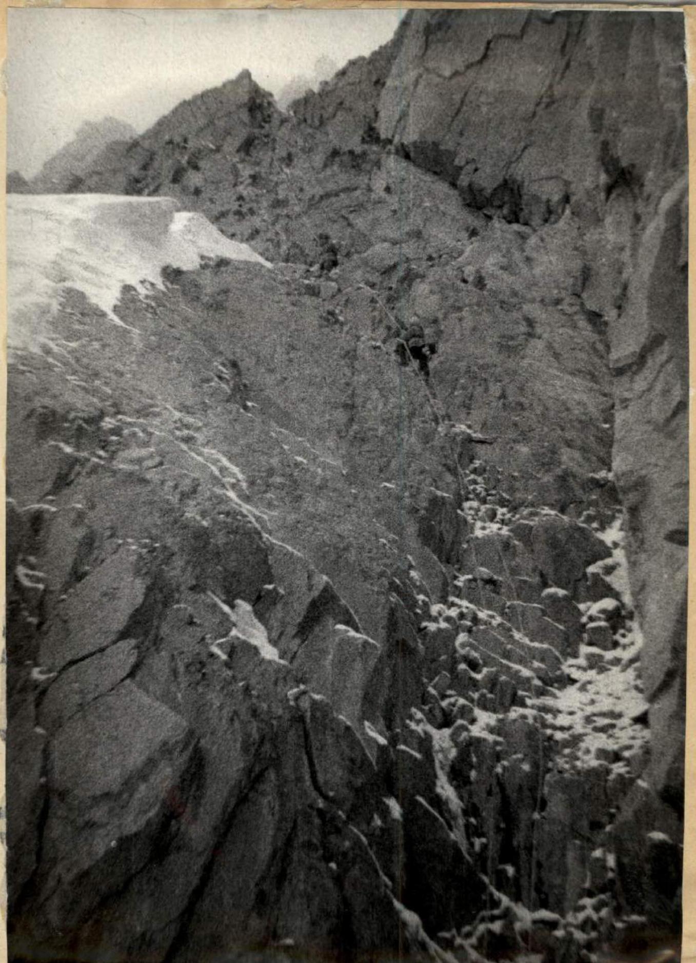
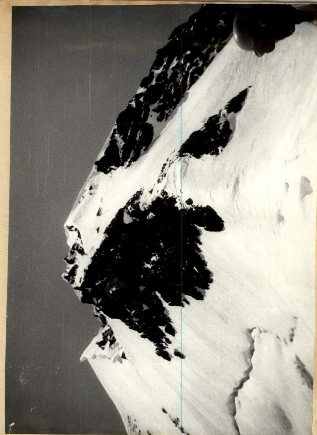
Destroyed rock wall. Snow on the ledges. Section R10.
Climbing is extremely complex. Use of ladders and wedges, cutting through snow cornices. The last "feather" ends with a sheer 40-meter wall into a narrow couloir leading to a snow-ice slope (R14–R15). From the last "feather," a diagonal descent via "dülfer" is made. 18:30 — it's time to set up a bivouac, but there's no suitable place. We decide to continue moving along destroyed and snow-covered rocks (along the ice couloir) and only at 20:00 exit onto a steep snow-ice ridge. Already in the twilight, we cut a platform in the ice and climb into one tent together. The weather is bad — snow, wind, frost. The height according to the altimeter is 4600 m.
July 6, 1975
The weather is overcast, cold wind, occasional snow. Exit at 8:30. Today, the BAKUROV — KRAPIVIN team leads. Ahead is a snow-ice slope with separate protruding rocks and then a snow-ice ridge (R16). We decide to wear crampons. The ice is hard and difficult to cut. Insurance is through rock and ice pitons. The ice ridge leads to destroyed rocks with a huge overhanging cornice (R17). BAKUROV goes first, being the most experienced "specialist" in cornices. Climbing is difficult and dangerous. We all watch closely as Vyacheslav works confidently and clearly. Finally, he's on the pre-summit ridge. The cornice is passed. The pre-summit ridge is snow-ice with large cornices on the north. On the ridge, there are monolithic gendarmes with steep walls. One of them has to be climbed "head-on" (R18). Movement along the ridge is in crampons, bypassing cornices, cutting steps, and using ropes (R19).
We stop for the night at 18:30. Height 5100 m. Preparation of platforms for tents. The weather is satisfactory, frost, and wind. The fourth day on the wall — the weather has been bad the entire time: clouds, snow, thunderstorm discharges. Upon reaching the main ridge, we saw almost the entire traverse through a break in the clouds. The picture is majestic and harsh. Two large gray giants, shining with snow and ice — 5529 m and Tamdykul 5539 m, and between them, a jagged ridge with several peaks around 5300 m. The significant snowiness and glaciation are striking.
July 7, 1975
The weather is satisfactory, with gradual improvement in the second half of the day, frost, and wind. Exit at 8:00. On the bivouac, as on all previous ones, a control cairn is left. The IVASHEV — MARKOV team leads. The ridge is combined — small rock gendarmes (often destroyed), snow and ice ascents (R20). Huge ice drops and giant snow cornices overhang to the north towards the V. Nepristupny glacier. Movement along the ridge is varied. It goes on simultaneously and alternately. We insure ourselves through ice and rock pitons, ice axe, snow and ice ledges. In some places, it's necessary to wear crampons and cut steps.
At 14:00, we approached the main ascent to the summit, represented by a 360-meter steep (55–65°) snow-ice slope turning into an ice ridge (R21). In the upper part, there's a bergschrund.
It's very difficult to climb because at such a height (5400 m), none of us have been this season. And the technical complexity of overcoming a snow-ice slope of such steepness is very high. We approach the last
Snow-ice ridge with gendarmes made of destroyed rocks. Cornices. Section R20.
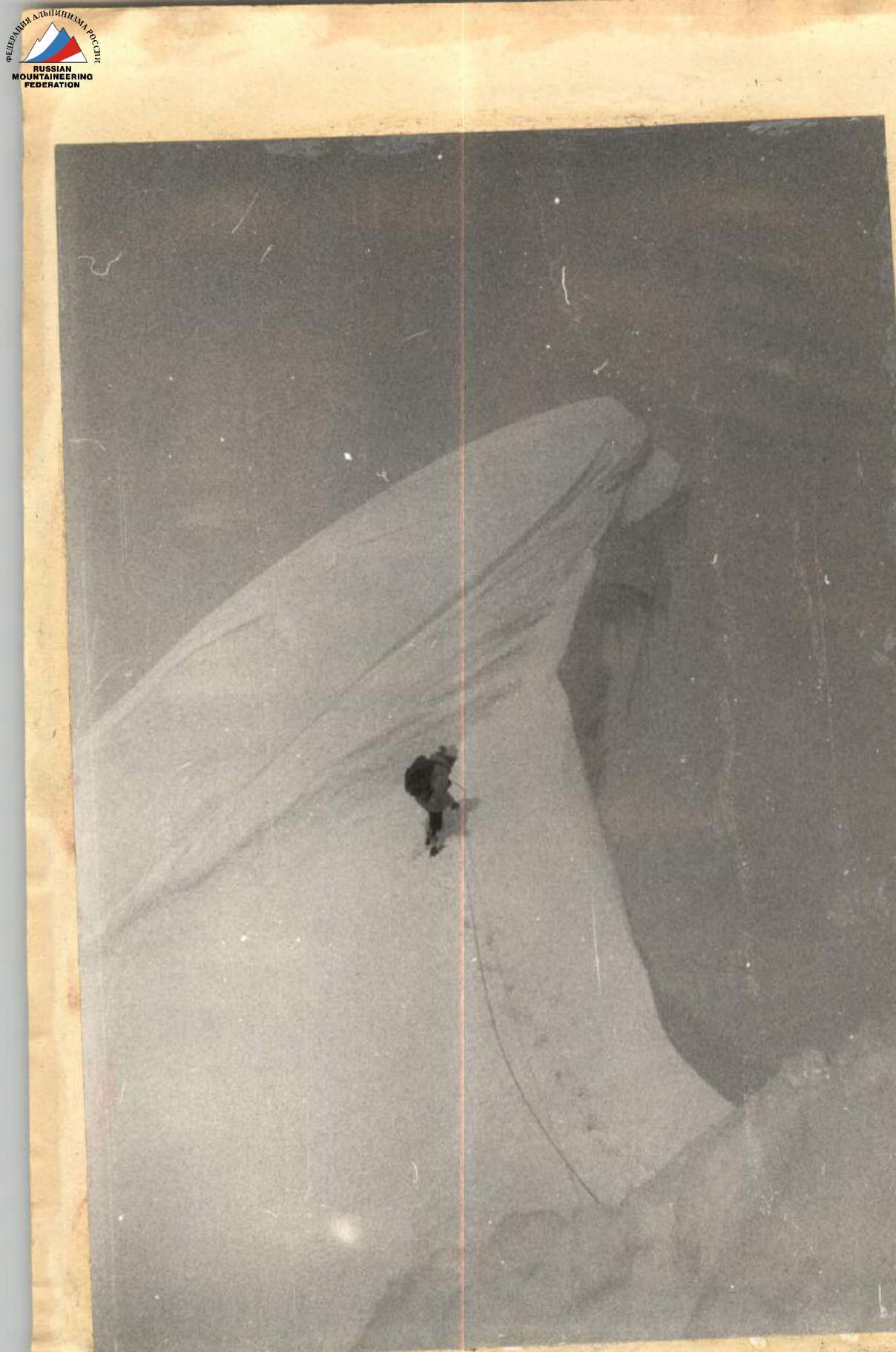
Passage of a cornice. Section R20–R21.
19:00. Climbing higher would mean staying without a convenient bivouac. We decide to spend the night in a hollow near the bergschrund. We fill in the bergschrund and set up a wall. By evening, the weather clears up. The entire Pamir is visible: peak Communism, Korzhenevskaya, peak Lenin, etc.
And our peaks stand out strongly against the Alay Range. So many beautiful and majestic mountains around! There are routes of various categories of difficulty waiting for their climbers.
July 8, 1975
The weather is clear, frost, and wind. We exit at 8:00. Today, the CHEREPOV — ZAKHOZHII team leads. We pass a steep ice ascent leading to the summit ridge (R22). Complex movement in crampons, cutting an ice cornice, steps, pitons, ropes.
Further, a snow-ice ridge (R23) with small ascents leads us to the Eastern summit of peak 5529 m at 11:00. We descend from the Eastern summit and then, along a snow ridge with cornices, exit onto the Western summit at 12:30. There's a descent 30 meters below to rock outcrops where we leave a cairn. The summit is very beautiful. After discussion, we unanimously name peak 5529 m peak "30 Years of Victory."
The descent from the summit goes along a snow ridge (R25) and then down a steep 50–60° snow slope with insurance through an ice axe (R26). On the ridge, starting from 5200 m, the snow is typically high-altitude: at the top, there are snow zastrugi; breaking through the crust, the foot sinks into loose, shifting snow. From this height, despite the blue sky and bright sun, it became very cold. Gloves, ropes, "prusiks," and clothing were covered with frost and ice due to the frost. On the ridge, there's a strong wind, and flags are waving. Further descent is along a destroyed rock ridge with small gendarmes (R27). Not finding a bypass, the 3rd and 4th gendarmes are climbed "head-on." We exit onto the Polikarpov pass. This is how the tourists from the Moscow Aviation Institute named this pass on August 21, 1972. They classified it as category 3B and determined the height using an altimeter — 5213 m. This note in a cairn and the platforms were the only trace left by humans before us on the route we traversed. We stop for the night at 18:30 on a wide, destroyed rock ridge. We dry our clothes and admire the mountain panorama.
July 9, 1975
The weather is clear, with a slight frost. Exit at 7:00. The BAKUROV — KRAPIVIN team leads to process the wall leading to peak "Pyramida." Along a destroyed ridge for 150 m, bypassing a gendarme on the right, and then along a snow-ice slope (R28) and destroyed rocks, we exit onto a saddle between the gendarme and peak "Pyramida."
From the saddle to the summit is 160 m. The slope is sheer rock-ice with many "live" stones. Rocks and ice are dusted with snow (R29). Rockfall-prone areas are passed in turn. Complex climbing, pitons, ropes. Descent to the south is 200–250 m along a destroyed rock ridge. Rockfall-prone. We exit onto the main snow-ice ridge with gendarmes made of destroyed rocks. Bypassing gendarmes is done along snow-ice slopes. We exit into an ice hollow (R30–31). Above the hollow, there's a large rock gendarme in the ridge. The gendarme is bypassed on the left. Traverse and ascent along a steep snow-ice slope with increasing steepness. Outcrops of small rock areas. Deep and loose snow; it's very difficult to climb (R32). A 40-meter rock ridge (R33); climbing is difficult, with alternating insurance, pitons. In the upper part of the ridge, there's a 20-meter descent along rock blocks and overcoming a rock ascent with a steepness of 75–80° "head-on" (R34–R35). We reach the summit of 5308 m ("Treзубец"). On the ridge and gendarmes, there are snow-ice cornices overhanging to the east. The further path is represented by a jagged and winding snow-ice ridge with gaps and steep ascents. Powerful ice cornices. In this part of the ridge, there are three large gendarmes (R36). Descent to the saddle under the central peak 5380 m is 30 m via "dülfer" down a rock wall and a steep snow-ice slope into an ice hollow (R37). We bivouac in the hollow at a height of 5300 m under a steep rock ascent.
July 10, 1975
Exit from the bivouac at 8:00. The weather is clear, frost, and wind. IVASHEV and MARKOV lead. From the bivouac, there are four ropes of snow-covered, heavily destroyed rocks. Climbing is difficult and dangerous. Rockfall-prone. Exit onto the summit snow-ice ridge with cornices (R38–39). Insurance is alternating, pitons, and outcrops. We reach the summit of 5380 m. We propose naming the peak "Zaщitnikov Leningrada" (Defenders of Leningrad). Descent to the south is along steep, destroyed rocks using sports climbing and "dülfers" (R40). Ascent to peak 5200 m is along snow-covered, destroyed rocks. Climbing is difficult. Insurance is alternating through pitons and outcrops (R42). Descent from peak 5200 m is initially along rocks for 60 m ("dülfer") and then along a snow-ice ridge for 200 m (R43–44). Ascent to peak 5080 m is along destroyed rocks (R45). Descent from peak 5080 m is along snow-covered rocks and a snow slope (R46). Exit under a sharp rock ridge leading to the third peak 4850 m (R47). Descent to the saddle under the northeast ridge of Tamdykul is along a rock bastion with snow areas (R48). Sports climbing, with simultaneous movement in the lower part (R49–50). On the saddle, we're greeted by a long-awaited cache. We stop for the night at 20:00 on a wide saddle under the main ascent of our traverse to Tamdykul. The weather is clear, windy, and frosty. Fatigue is felt, and ahead lies the most challenging part of the traverse.
July 11, 1975
The weather is clear, frost, and wind. Exit from the bivouac at 8:00. Today, we're faced with the path that has captivated our attention for several days — the ascent along the northeast ridge of Tamdykul. A steep 800-meter ridge with powerful ice drops adjacent to the rock summit tower. Today, the CHEREPOV — ZAKHOZHII team leads. They are given one lightened backpack for the pair. From the bivouac, we move along a snow-ice slope under a rock gendarme (R51). The firn is hard, and the ice is solid. We move in crampons. The gendarme's wall is vertical, with sloping holds and weak fracturing. After unsuccessful attempts to find a bypass, CHEREPOV puts on galoshes, and ZAKHOZHII hands him a set of pitons on a loop. Climbing is very complex, using artificial holds. Thirty meters of a steep, icy wall with few holds, leading into a wide internal corner turning into a chimney. Climbing is very complex and dangerous. Ladders are necessary, and pulling up backpacks is mandatory (R59). Feet and hands freeze significantly. Above the rocks, there's a steep ice ridge, with ice drops on the right approaching the main ridge (R60–R61). Traverse under the ice drops along natte e, steep (60°) ice in the upper part of the ice collector. Icicles the size of a human arm are rooted in the slope like columns, and some hang over our heads. Extremely complex traverse. Cutting steps only in a closed stance, crampons, pitons, ropes. We cross an ice couloir and exit onto rocks covered in ice, with a steepness of 65°. Each hold has to be cleaned of ice. Insurance is through ice and rock pitons (R62–R63). Exit onto the ice ridge, which is particularly complex in the first half — very steep (60–65°), pure natte ice. Typical ice wall (R64). Climbing the ridge is extremely difficult and dangerous. The passage requires cutting steps, and the ice ridge above us showers the group below with ice fragments — at best (R65). We leave the ridge to the right along a snow-ice slope and traverse it to a steep rock wall (R67). Very complex climbing. Use of artificial holds, ropes. Climbing such rocks on ropes at a height of 5450 m is extremely challenging. We assist with top-rope insurance. Finally, we reach the pre-summit ridge (R68). But there's little emotion. We sit on our backpacks, silently gazing at the unfolding panorama of the Matcha mountain node. We need to find a place for the night. The jagged rock ridge (R68) is complex, with much snow, ice, and cornices. The bivouac platforms turned out to be good, on a narrow snow saddle, with a cornice on one side and a couloir on the other. A strong wind blew all night, cold, but clear. We slept well. It was a very difficult day, filled with complex technical work: use of ladders, wedges, jammers, danger of rockfalls and icefalls, steepness and height, long time on the route. All this is behind us.
July 13, 1975
Today is a magnificent day.
- It's the 13th.
- It's Slava Bakurov's birthday.
- Today, we're supposed to ascend to the summit of Tamdykul. Since 5:00, CHEREPOV has been busy with primuses. The decoration of any table — "cocoa" — is ready. Many congratulations, little food. And again, we're on our way. The IVASHEV — MARKOV team leads today. Exit from the bivouac at 8:00. The weather is clear, frost, and wind.
The rock ridge leads to the pre-summit snow-ice ridge (R69–R70) with a series of gendarmes. Climbing is very difficult, but this is likely not because we "overeated" at the festive breakfast; it's just the high altitude — 5500 m. We reach the summit of Tamdykul 5539 m at 10:30. Now, it's time to descend. We traverse a decreasing snow-rock ridge with several large gendarmes and cornices (R71–R72). The rocks are very heavily destroyed throughout the descent. We exit onto a small rock shoulder. Below, snow walls descend (R73). Sports "dülfers." Significant rockfall danger. We have to bypass part of the heavily destroyed ridge along the slopes. A steep snow couloir on the southeast slope of the ridge, traverse of a snow slope, and ascent along a snow-ice slope and destroyed rocks back onto the ridge (R74–R76). 19:30. Cutting platforms on a snow-ice saddle of the ridge for tent setup. Height 4900 m.
July 14, 1975
The thirteenth day of the traverse. Exit at 8:00. The weather is clear, frost, and wind. The CHEREPOV — KRAPIVIN team leads today. From the bivouac, we move directly to the gendarme's wall. Climbing is complex. Use of ladders (R77). Exit onto a heavily jagged rock-snow ridge with gendarmes and gaps (R78–R79). Cornices. Bypassing and ascending gendarmes, descents. Descent along an 800-meter snow-ice slope with rock outcrops, steep in the upper part, with a steepness of 50–55°. Ropes, movement in crampons, ice axe, pitons (R80). Exit onto a rock ridge (R81) departing from the main ridge to the west and leading to the Tamdykul glacier. From the ridge, we descend along destroyed rocks to the glacier (R82). The path along the glacier is familiar. When bypassing the icefall along the rocks, there are two descents via "dülfer" (R83). 16:00. Finally, we're on the Archa-Bashi glacier, at a large stone and the observers' tent. Warm congratulations, tea, a short rest. Then, along the Archa-Bashi glacier and further to the base camp. We descend at 19:30 on July 14. Thus, the two-week traverse is completed.
Team Captain: M. Zakhizhii
Table of main route characteristics
Route: Traverse of peaks 5529 (ascent from the east), 5300 m, 5308 m, 5380 m, 5200 m, 5080 m, 4850 m, and Tamdykul 5539 m.
![img-20.jpeg]({"width":1436,"height":1901,"format":"Jpeg","uri":"https://summitx.info/media/1/2Pbs760YLSJdcEjGwb4EvrdGfgUUTvvI/img-20.jpeg","id":647869 ↗
Comments
Sign in to leave a comment