
Ascent Log
-
Ascent category — technically challenging
-
Ascent region — Pamir-Alay
-
Ascent route to peak Tamdykul (5450 m above sea level) — Eastern peak via the eastern ridge.
-
Ascent characteristics: — elevation gain — 2250 m; — average steepness — 44°; — length of complex ice section — 45°, 1050 m; — length of complex rock section — 80°, 100 m;
-
Pitons used: — rock pitons — 25 — ice screws — 27
-
Time taken to reach the summit — 23.5 hours
-
Number of nights on the route — 2;
-
Support team from the Taganrog Alpine Club under the city physical culture and sports committee.
-
Group composition:
Naumov Vladimir Konstantinovich — 1st sports category. Leader: Fedorov Anatoly Ivanovich — Master of Sports. Makarenko Boris Fedorovich — 1st sports category. Trofimov Sergey Semenovich — 1st sports category.
-
Group coach — Nepomnyashchy Anatoly Vladimirovich — Master of Sports.
-
Date of departure on the route — August 16, 1976, date of return — August 19, 1976.

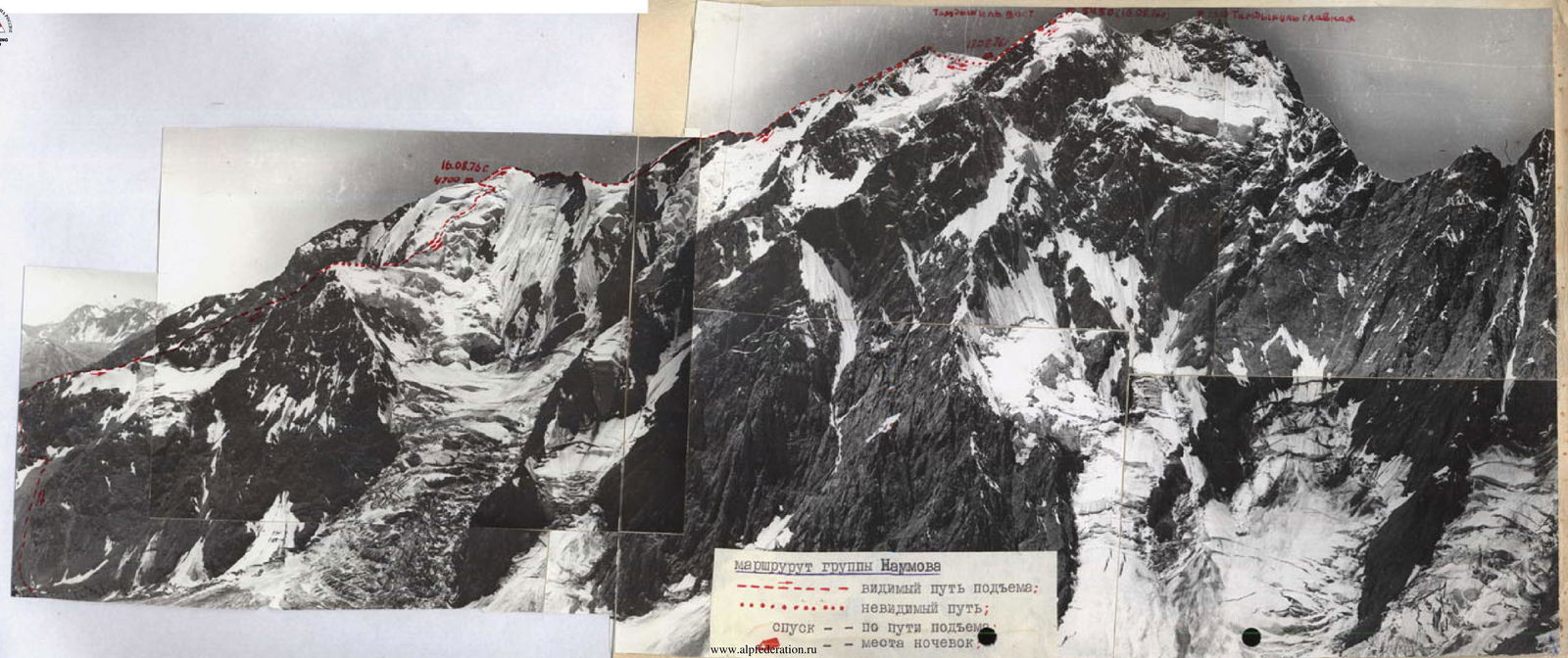
Naumov's group route: visible ascent path; invisible path; ascent path; overnight locations.
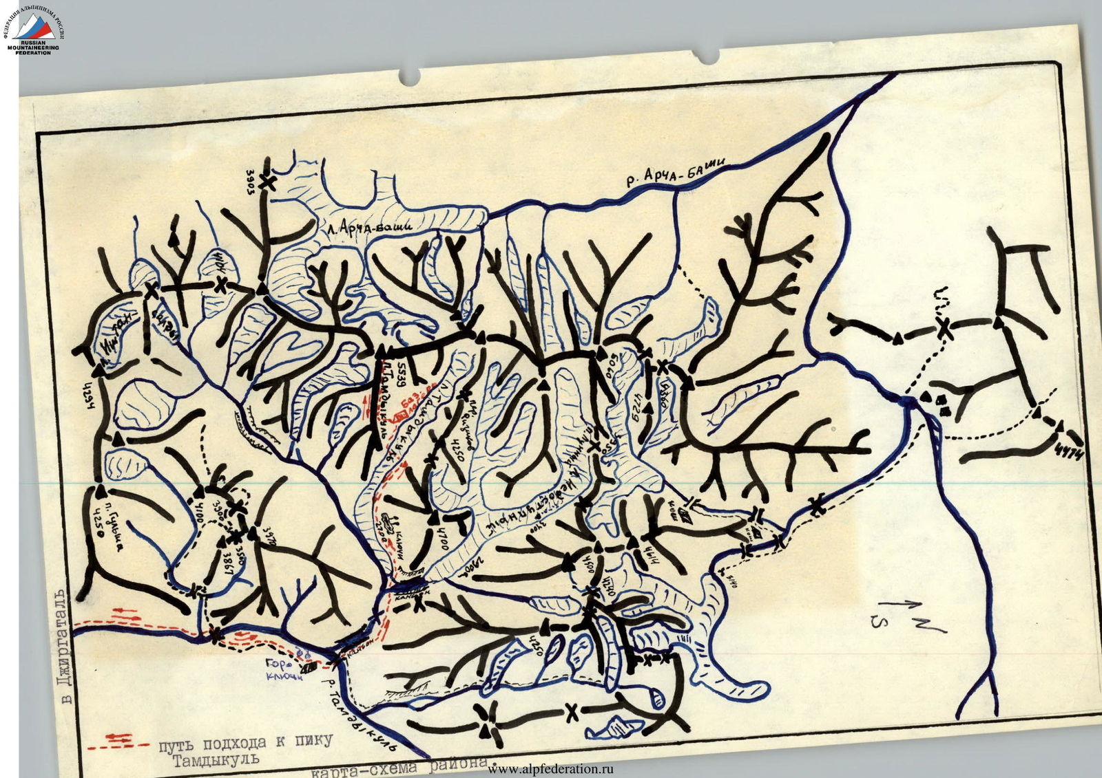
Approach path to peak Tamdykul (area map).
From the base camp to the start of the ridge, the elevation gain is about 300 m, with a steepness of 40° and a slight gain in height from the start of the ridge to the first steep ascent, approximately 300 m (1 hour). Then there is a 35–40° ascent of 100 m and an exit to a gentle section of the first hanging glacier (about 30 minutes). Movement on the glacier was done in crampons, with insurance on the firn using an ice axe and on the ice using pitons. Due to good weather, the intended ascent path was clearly visible. Further on, at the start of the glacier, a rock ridge was visible, but after traversing it for 600 m, a large glacier came into view. The ascent path up the center of the glacier was clearly visible, and the group continued in that direction. Many complex bergschrunds and crevasses were encountered along the way. A characteristic feature of this glacier is a large ice dome located in its upper part and adjacent to the ridge leading directly to peak Tamdykul. The ascent path in the upper part passes along the left part of the ice dome towards the depression in the rock ridge. The length of this snow-ice section is about 1650 m. The average steepness is 55°. 15 tubular ice screws were used on this section. From the start of the glacier to the depression in the ridge — 5.5 hours. The altimeter showed a gain of 1500 m. This is a good spot for an overnight stay. The height is 4700 m.
August 17
The group departed from the 4700 m overnight location at 8:00. Immediately after the overnight location stands a "gendarme" that needs to be overcome head-on with piton insurance. 4 pitons were used. Further movement was along a relatively easy ridge with some gain in height, alternating with depressions filled with ice. To the left, easy scree gullies descended, and to the right, the ice dome of the previously described glacier dropped down. Movement along the ridge was mostly simultaneous, and in the depressions, it was alternate. At the end of this ridge stands another "gendarme," seemingly composed of stacked slabs. After preliminary reconnaissance by a pair, it became clear that it was necessary to descend to the left down a scree gully to the glacier and traverse to a saddle behind the gendarme. The height of the saddle is again 4700 m. Overcoming the gendarme head-on is generally possible, but there is no suitable location for reliable insurance for a rappel (2 ropes).
After the saddle, the path continues along a narrow ice crest (50 m) with a very complex rope section at the end, leading to rocks. To the right of the crest, the glacier drops down steeply, and to the left, a slope descends with a steepness of 60–70°, featuring a large bergschrund in the lower part, clearly visible when approaching the saddle. Insurance was provided by pitons (4 pitons). After the ice crest, we exit onto rocks. Further movement is relatively easy: first along a slope, then along the boundary between rocks and snow, we reach a snow ridge with cornices, ending again with an ice crest (40 m) leading to rocks. The path then goes between destroyed rock towers, crossing scree gullies that are quite steep and rockfall-prone to the left and upwards with a sharp gain in height. Movement was carried out closely in pairs. Often, entire "slabs" of this rock conglomerate gave way underfoot. The length of this quite steep slope is about five rope lengths.
Further on, the slope becomes gentler, and we reach the start of a large ice dome. It appears to be a nodal point of two ridges: one — the eastern ridge along which our group is moving, and another approaching this nodal point from the southwest. This dome looks like an indistinct triangular pyramid, with one edge being the ridge coming from the east, another edge being the ridge approaching from the southwest, and the third edge being the ridge leading further towards peak Tamdykul. — To the right, it drops down with ice walls — To the left, it descends with a 70° slope.
The path then follows the "eastern" edge of this ice pyramid with a steepness of 40–45°. Movement was alternate with thorough piton insurance, with a significant part of the path on front points. The length of this ice ridge is five rope lengths. Further on, the ridge becomes gentler, and we enter a small ice depression. This is a good spot for an overnight stay.
After the depression, we descend into a gap in the ridge already leading to the summit. From the 4700 m overnight location to the depression — 6 hours. We descend into the gap via an ice wall (1.5 rope lengths). Immediately in front of us stands a block-like large gendarme. — To the right, its walls drop down steeply towards the glaciers. — To the left, along the gendarme, a narrow, eventually dropping off, scree shelf descends.
At the end of the shelf begins the throat of a steep scree gully.
The path through the center of the "gendarme" appears quite complex, as the "top" of the gendarme is composed of seemingly "piled-up" stones, clearly visible when descending into the gap before the gendarme. By passing the gendarme to the left along the aforementioned scree shelf and overcoming the throat of the gully (rocks!, piton insurance, movement along fixed ropes!) — two rope lengths — we exit onto a small shoulder, which is like the start of a rock buttress branching off from the gendarme and descending downwards to the west.
Another two rope lengths of complex climbing upwards — and we exit into a small gap in the rock "knife-edge" leading further to the summit from the aforementioned gendarme. This is the key section of the route according to both groups.
This rock "knife-edge" features short rock walls, gaps, and standalone destroyed small towers. Bypassing these towers is very dangerous due to many large frozen snow-ice plugs with holes on the right side, remnants of a glacier that apparently once started immediately from the "knife-edge" but has now "sunk" far down. Thus, immediately from the "knife-edge," walls descend downwards. — To the left along the path to the west, there are also very steep walls.
This section requires thorough loop insurance (long channel pitons are necessary). Movement is only in autonomous pairs. The length of this "knife-edge" is about five rope lengths, with a 20-meter sport rappel into the gap before a huge rock massif featuring huge towers and scree gullies descending to the left towards the west and to the saddle.
The rock massif, as it is offset with its larger part to the left along the path, adjoins the continuation of the ridge and is essentially its continuation. — To the right along the path, the top of a steep snow-ice slope is visible, dropping down steeply with an ice wall.
Further from the saddle, movement is along the boundary between a small large-block scree and a small snow depression, turning left into the start of a scree gully coming from the shoulder of the aforementioned rock massif. The steepness at the start is 30–35°.
Then we exit the gully onto its right side and, overcoming short rock walls with a steepness of 75–80°, we reach a shoulder of this massif, which is like a continuation of the ridge (here, a total of five rope lengths).
Here, the ridge after the shoulder sharply turns to the west, descending with a buttress to the left — downwards.
Further on, from the turn of the ridge, it is necessary to rappel (3.5 rope lengths) onto a snow ridge transitioning into a wide snow shoulder descending towards peak Tamdykul — Eastern (2nd summit).
Here, when approaching the summit, the snow ridge widens, transitioning into a wide snow shoulder. On this shoulder, we met our team, which on that day (at 14:00) had already reached the summit from the north via the wall and descended onto this snow shoulder.
Our group reached the overnight location of the previous group at 19:00. The height according to the altimeter is 5300 m. Here, our group also settled for the night.
During the day, 21 rock pitons and 12 ice screws were used. Pure working time — 10.5 hours.
August 18
The morning greeted us with bad weather. It was very cold, with strong wind and fog. At 7:30, the group set out to conquer the summit.
Following in the footsteps of the previous group, we approached the start of a scree gully leading directly to the summit via steep but short ice-firn ascents on front points. After crossing this gully in its lower part and exiting onto its left side upwards — a small rock ridge composed of blocks.
Moving along the sides of the blocks or between them, sometimes descending into the increasingly deepening and narrowing gully, we reached its start — a small shoulder. 4 rock pitons were used on this section.
From the shoulder, another rope length to the left — and we are at the SUMMIT!!! Time — 9:00. Height — 5450 m.
Further down to the overnight locations, we descended via the ascent route. The descent was done in a sporty manner. From the overnight locations, the descent continued along the ascent route jointly by both groups. At 18:00, we were at the 4700 m overnight location.
On August 19, 1976, at 16:00, we were back at the base camp.
Note: Regarding the judges' comment "following in the footsteps of the previous group," we provide the following clarification: on the evening of August 17, 1976, when our group, finishing the route, approached the pre-summit 200-meter ridge, we met Nepomnyashchy's group, which had finished climbing a different route for the USSR championship on the same peak an hour earlier and had descended to an overnight location 200 m below the summit. These 200 m of their descent coincided with the final section of our route and constitute only approximately 6% of the 3740 m of the route climbed for the first time. Considering also that this section is not a key section of our route, following in the footsteps of the previous group cannot, in our opinion, diminish the priority of the first ascent.
Group leader B. Naumov.
Comments
Sign in to leave a comment