Ascent Passport
- Gathering Name: Training and climbing gathering of the Chelyabinsk Region Alpinism Federation and Magnitogorsk Alpine Club.
- Region: 5.1.4. Pamir-Alay, Kyzylkia Ridge, Suychakty Valley.
- Summit: Legendary Magnitka (4550 m according to classifier), 4632 m according to map and GPS.
- Ascent Route: via the right counterfort of the Western ridge.
- Ascent Type: Combined
- Difficulty Category: First ascent, proposed 4B.
- Route Characteristics: Height difference — 698 m;
Route length — 2932 m; including wall part length — 435 m;
length of 4th category sections — 885 m; Average steepness — 15°. Wall part — 73°
- Pitons driven: Rock — 31;
Ice — 6; Chocks — 47.
- Climbing hours — 18:00.
Climbing days — 2 days.
- Route entry: July 25, 08:00.
Summit reached: July 26, 14:30. Return to base camp: July 26, 17:00.
- Team: Magnitogorsk Alpine Club team.
Leader: Soldatov Sergey Yuryevich, Master of Sports, Magnitogorsk
Team Members:
- Makarov Evgeny Sergeyevich, 2nd sports category, Magnitogorsk
- Mavriinskaya Agata Viktorovna, 2nd category, Magnitogorsk
-
Team Coach: Pgolshi Viktor Pavlovich, Master of Sports, Magnitogorsk.
ASCENT AREA DESCRIPTION
The Kyzylkia Ridge crest is oriented in a latitudinal direction, north of the Alay Ridge in its eastern part. Starting south of the city of Osh, the crest extends southward:
- with a low, grassy section,
- then with a scree ridge,
- with scree and lightly destroyed rocky peaks,
and approaches one of the main (by height) peaks of the ridge — Shankol, 4630 m high.
Further, the ridge gradually turns westward and, through the Tsvingling ice pass (4150 m), approaches the Joldyilga massif with the eponymous pass — 4180 m — to the southwest.
West of the Joldyilga pass, the ridge is heavily serrated with peaks that do not significantly rise above the numerous jandarms:
- Chelyabinsky Rabochy peak with the northern Karogay spur
- Legendary Magnitka with the southern Tavriya spur
The scree southern slopes of Legendary Magnitka descend to the South Joldyilga and Jyrty glaciers, while the ice-snow northern slope of the peak descends into the Suychakty valley, feeding the northeastern part of the Kirgizata glacier.
Approach to Legendary Magnitka via the Suychakty valley. From the base camp opposite the Mazhar mountain, ascend the valley along the right bank of the Suychakty River. Then, following the river flowing along the left slope of the valley, reach the first terminal moraine that blocks the entire valley. Cross to the right bank of the Suychakty stream and ascend the moraine. Continue along the trail, passing the southwestern slopes of the Bolshaya Ruchyeva peak, and approach the northeastern branch of the Kirgizata glacier. Here, on the moraine, near the glacial lake at an altitude of 3900 m, is the starting bivouac. The approach from the base camp takes 8–10 hours.
ROUTE DESCRIPTION BY SECTIONS
R0–R1 — the route begins at the confluence of two inclined, clearly defined snow-ice couloirs descending from the Western ridge. At the end of the ascent along the rocky moraine, before exiting onto the ice, put on personal gear.
R1–R3 — two sections, moderately destroyed with good rock relief. Passed with free climbing and using artificial support points. Hooks, chocks, and friends are used equivalently.
R3–R5 — passage of a wall with a slope of 70–75°. There are sufficient cracks for hooks and chocks. Insurance stations are convenient.
R5–R7 — passage of two ropes of increased difficulty. ATO (Artificial Technical Obstacles) and "fif" are used. For safety, station R6 is under an overhang. Rocks are weathered. Exit to a horizontal ledge.
R7–R8 — a 40 m section along a 75° wall. Movement is directed towards the left inner corner along cracks and smoothed rocks on friction.
R8–R11 — three ropes along a relief of ledges and sheer walls lead to a ledge, completing the wall part of the route. The site on R11 is convenient for rest. The area is leveled, and a bivouac is organized.
R11–R12 — a long section along destroyed rocks and stony scree to the exit onto the Western ridge. Individually standing rocks and jandarms are bypassed on the right. Movement is simultaneous, not dangerous, without ropes.
R12, R14 — a ridge section consisting of a series of несложных rocks and snow slopes. Insurance is used interchangeably. Exit to the summit of a two-toothed jandarm.
R14–R15 — descent from the ridge 100 m along an ice couloir in the direction of Boris Ruchyev peak. Insurance is organized on ice screws. Exit to a sloping snow field.
R15–R16 — a ridge glacier, covered with snow. Passage over a bergschrund. Movement is in crampons with ice axes.
R16–R17 — a 300 m section along a rocky ridge and snow-covered sections. Movement is simultaneous, with insurance on ledges.
R17–R18 — descent from the ridge to the right slope (two 20 m rappels). Rope is fixed to a ledge with a pull-through.
R18–R19 — bypassing rocky bastions on the right along ledges, scree, and firn (450 m). For convenience, ropes are stowed in a backpack.
R19, R20 — rocks of medium difficulty and scree along a couloir lead to the ridge. Along the ridge, 300 m of snow-ice western slope of the peak.
R20 — the summit is rocky. A commemorative plaque is installed on a ledge: "Peak Legendary Magnitka. The plaque is installed by the Magnitogorsk Alpine Club in honor of the 80th anniversary of the city". Height according to classifier — 4550 m. Height according to map — 4632 m, coincides with GPS height. Proposal: to change the height mark of the mountain to 4632 meters.
Descent from the summit in a northwest direction towards the Uraltsi pass along snow fields. Movement is in crampons with ice axes. Not reaching the pass, turn left towards the upper lake along the glacier and stony scree.
| Total | 31 | 47 | 6 | 2632 | ||
|---|---|---|---|---|---|---|
| - | - | - | 300 | |||
| 819 | ||||||
| - | - | - | 450 | |||
| Descent 2×20 m | 100 | |||||
| - | - | - | 300 | |||
| 816 | ||||||
| Rock hooks | Chocks | Ice screws | UIAA | Length | ||
| - | - | - |  | 150 100 | 4А | 10⁸ 558 |
| :--: | :--: | :--: | :--: | :--: | :--: | :--: |
| Descent 100 m (ice) | 6 | |||||
| - | - | - |  | 300 200 | 36 2А | 10⁸ 258 |
| Rock hooks | Chocks | Ice screws | UIAA | R12 | Length | Difficulty |
Table in symbols
UIAA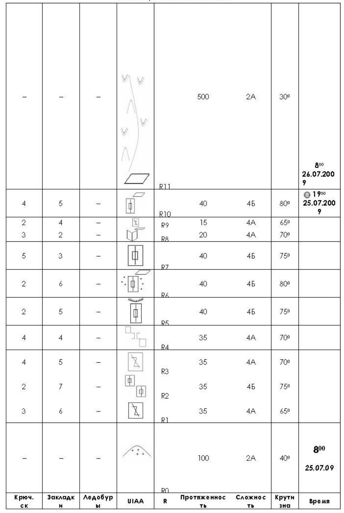
PREPARATION FOR THE ASCENT
Regular training throughout the year and participation in competitions ensured good overall physical preparation of team members before heading to the mountains.
The training gathering in Kyrgyz-Ata began with planned training sessions on mountainous terrain. On the rocks, they practiced:
- techniques of movement in rope teams;
- techniques of organizing insurance points.
The training cycle concluded with an ascent of the Mazhar mountain.
The group approached Legendary Magnitka in an expanded composition: S. Soldatov, P. Ivanovsky, N. Arzamastsev, E. Makarov, and A. Mavriinskaya.
The approach to the upper lake with lunch took a whole day. After setting up at the bivouac, they spent a long time studying the counterforts of the Western ridge to determine the best option for the first ascent.
As a result of discussions, the line of ascent was determined — via the right counterfort. This is to the right of the 4A category route passed in 1979 by a team of Magnitogorsk climbers during the Chelyabinsk Regional Council of the All-Russian Mountaineering Federation (ChOKVAM) gathering under the leadership of I. Galibuzov.
The route project approved by the team was named "Via the right counterfort of the Western ridge".
The team composition for the first ascent was determined before the exit. Three: S. Soldatov, E. Makarov, A. Mavriinskaya will exit on July 25, 2009, on the declared route. The duo: N. Arzamastsev and P. Ivanovsky will observe the team's actions on the first day (July 25, 2009) and on July 26, will exit onto Legendary Magnitka via the 1st category route. The descent from the summit is planned for the combined group in full composition.
TACTICAL ACTIONS OF THE TEAM
The team chose a calm approach to the first ascent, i.e., without using auxiliary helpers to "get under" the wall and pass it without processing, maximizing free climbing. Considering the large length of the ridge part of the route, which is not simple, it was decided in advance:
- to stop for the night upon reaching the counterfort;
- to conduct the ascent over two days.
The team was mobile. To varying degrees of mastery, everyone was able to work as the first.
The section R0–R7 was first worked by E. Makarov.
The second part of the counterfort from R11 was led by S. Soldatov.
The ridge part was passed with constant rotation of the first.
On the rocky section, they moved alternately. The first worked on a double rope. The last ascended via double "perlines", organizing their insurance independently on "jumars".
On the rocks, effective were:
- anchor hooks
- "ice fif"
This gear was used throughout the entire route. This allowed for making half the number of points for intermediate insurance and ATO (Artificial Technical Obstacles) and significantly increased the speed of passage. The main emphasis in the ascent via the counterfort was on free climbing with insurance using "fif".
During the descent from the ridge along the ice couloir, ice screws were used on three ropes. The last descended on insurance with two ice axes in four beats, removing intermediate ice screws along the way. Everyone moved in crampons on front teeth.
The combined descent from the summit did not occur. The duo, having visually confirmed and received radio confirmation of the team's exit to direct visibility to the summit, descended to the camp earlier than the team by 2 hours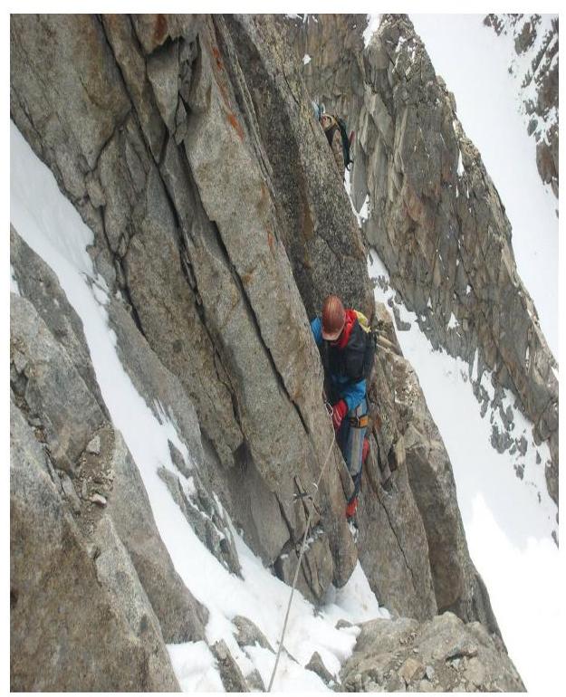
Photo #5. Section R2–R3. Point of съемки
Ф5.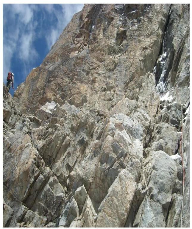
Photo #6. Section R3–R4. Point of съемки
Ф6.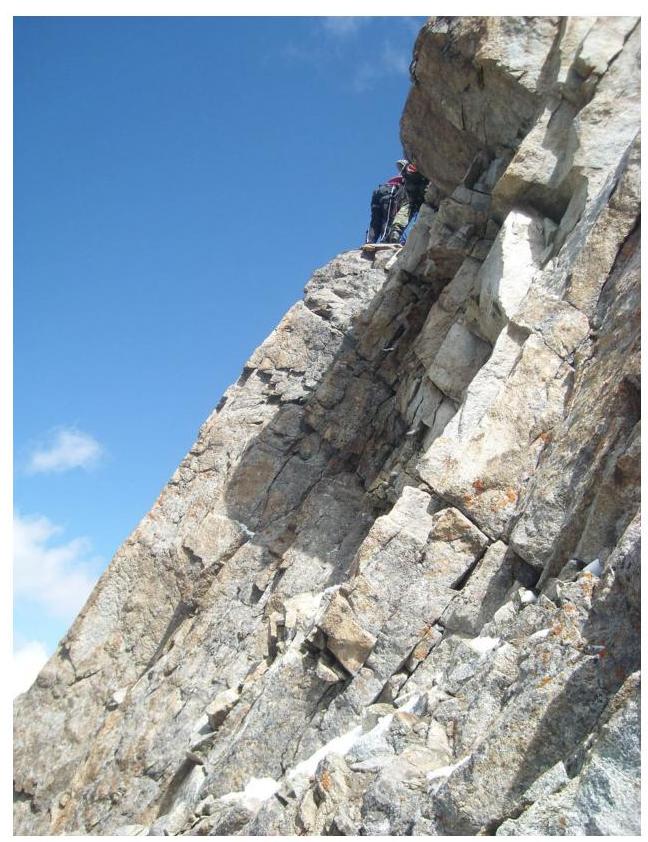
Photo #7. Sections R3–R4, R4–R5.
Point of съемки
Ф7.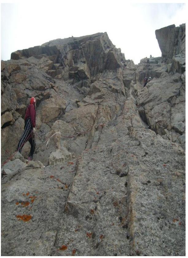
Photo #8. Beginning of section
Point of съемки
Ф8.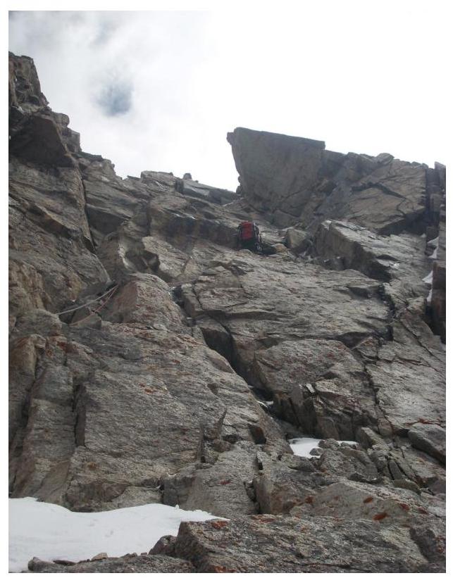
Photo #9. Upper part of section R4–R5. Point of съемки
Ф9.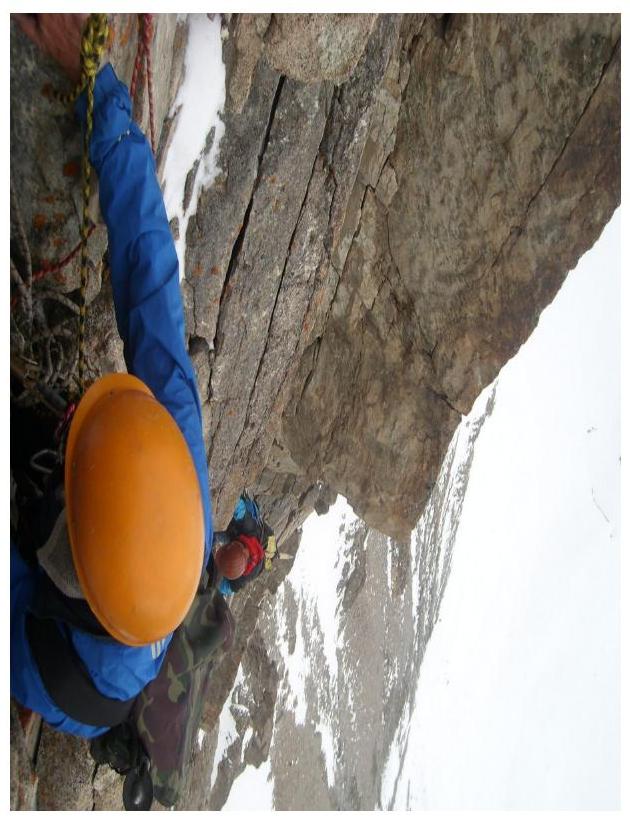
Photo #10. On section R4–R5. Point of съемки
Ф10.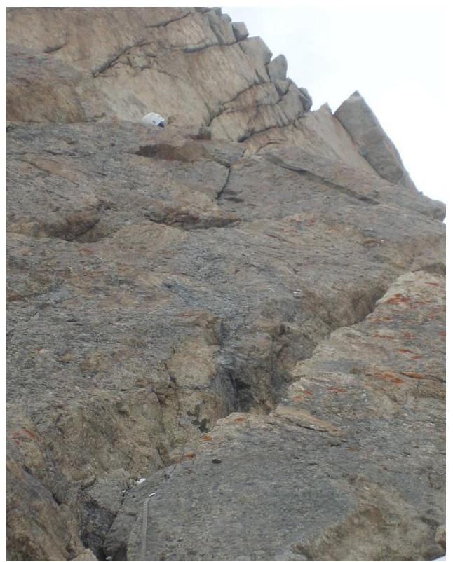
Photo #11. Section R5–R6.
Point of съемки
Ф11.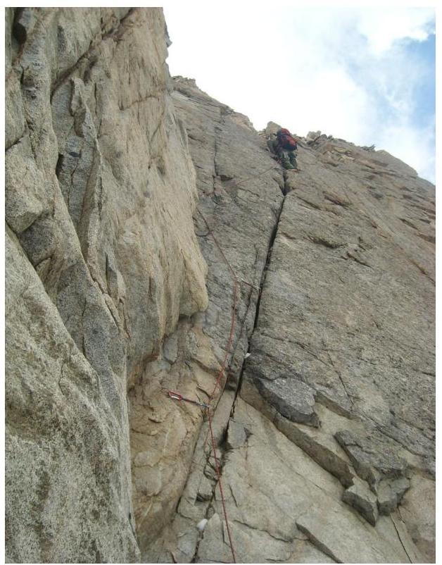
Photo #12. Beginning of section
Point of съемки
Ф12.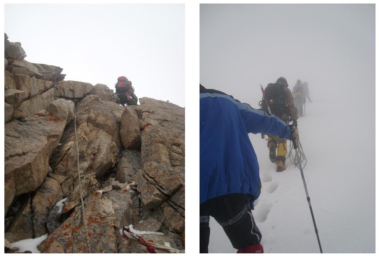
Photo #13. Upper part of section R7–R8. Point of съемки Ф13.
Photo #14. Section 9–10. Point of съемки
Ф14.
Photo #15. On the summit of Legendary Magnitka 4632 m. August 6, 2009, 16:30. Point of съемки Ф15.


