ASCENT DOCUMENTATION 48
- CATEGORY — TECHNICAL
- REGION — KICHIK-ALAY ridge (Kurgan (south))
- PEAK — S.M. TSVILLINGA peak 4326 m, first ascent via the north face (COMB.)
- PROPOSED difficulty category — 5B
- Height difference — 910 m Length of sections with 5–6 difficulty category — 347 m Average steepness — 70°
- PITS ON: For belaying: rock — 77, for creating artificial anchors (ИТО): rock — 9. Ice — 10. Bolts — (no data)
- Number of climbing hours (ascent) — 11:25 (plus 4 hours 00 minutes for processing by a pair)
- Number of nights on the route — ONE, in a tent on a prepared comfortable and safe site
- LEADER: 1. MURZAKHANOV Zif Zufarovich — Candidate Master of Sports PARTICIPANTS: 2. BOCHKOV Vladimir Viktorovich — 1st sports category 3. SAMOKOTIN Yuri Timofeevich — 1st sports category 4. FEDYAEV Alexey Leonidovich — 1st sports category
- COACH: Master of Sports LEVIN M.S.
- Date of departure on the route — July 21, 1981 Date of return from the route — July 22, 1981
CHELYABINSK REGION ALPINISM FEDERATION 1981 year legus www.alpfederation.ru↗
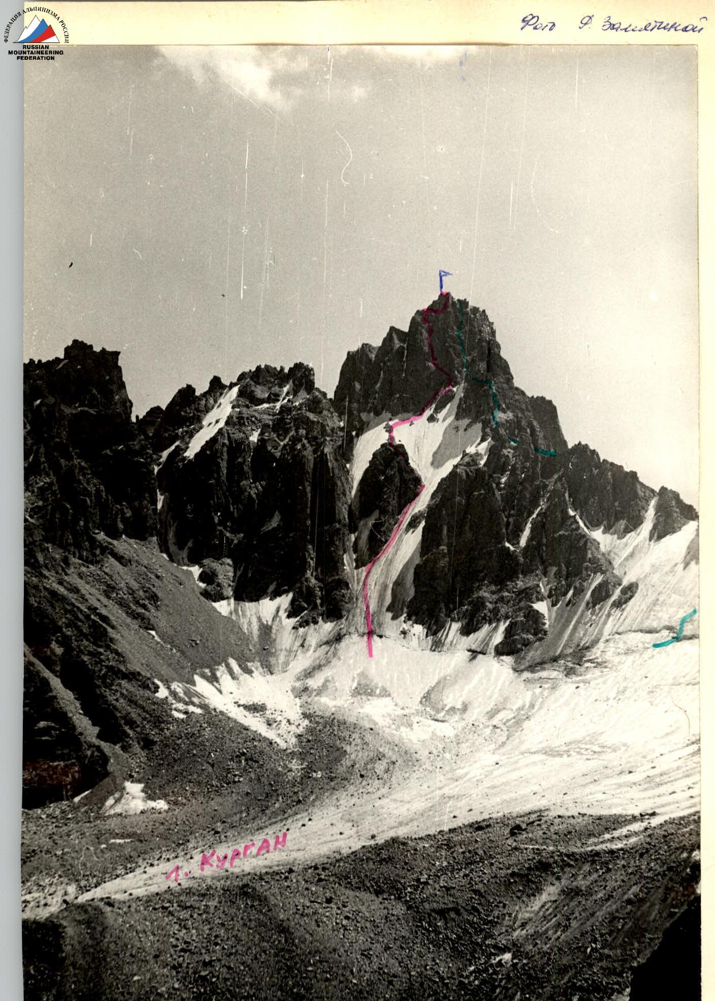


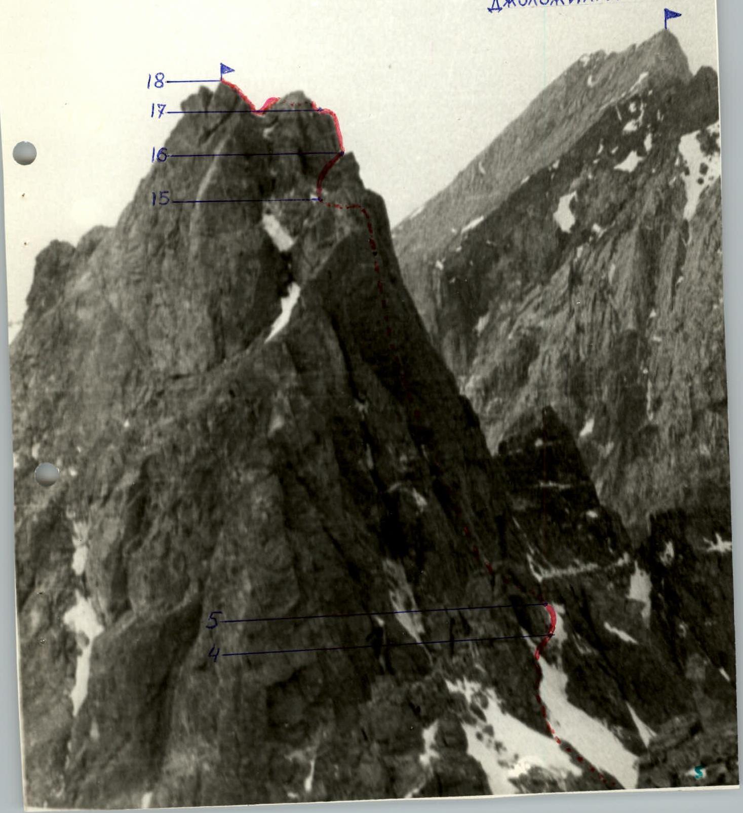
Photo by F. Zamyatina (1/77 year) — the route of the first ascenders (G. K. Rozhanskaya +3, 1977 year) 4A difficulty category — the route of the first ascent via the North Face www.alpfederation.ru↗
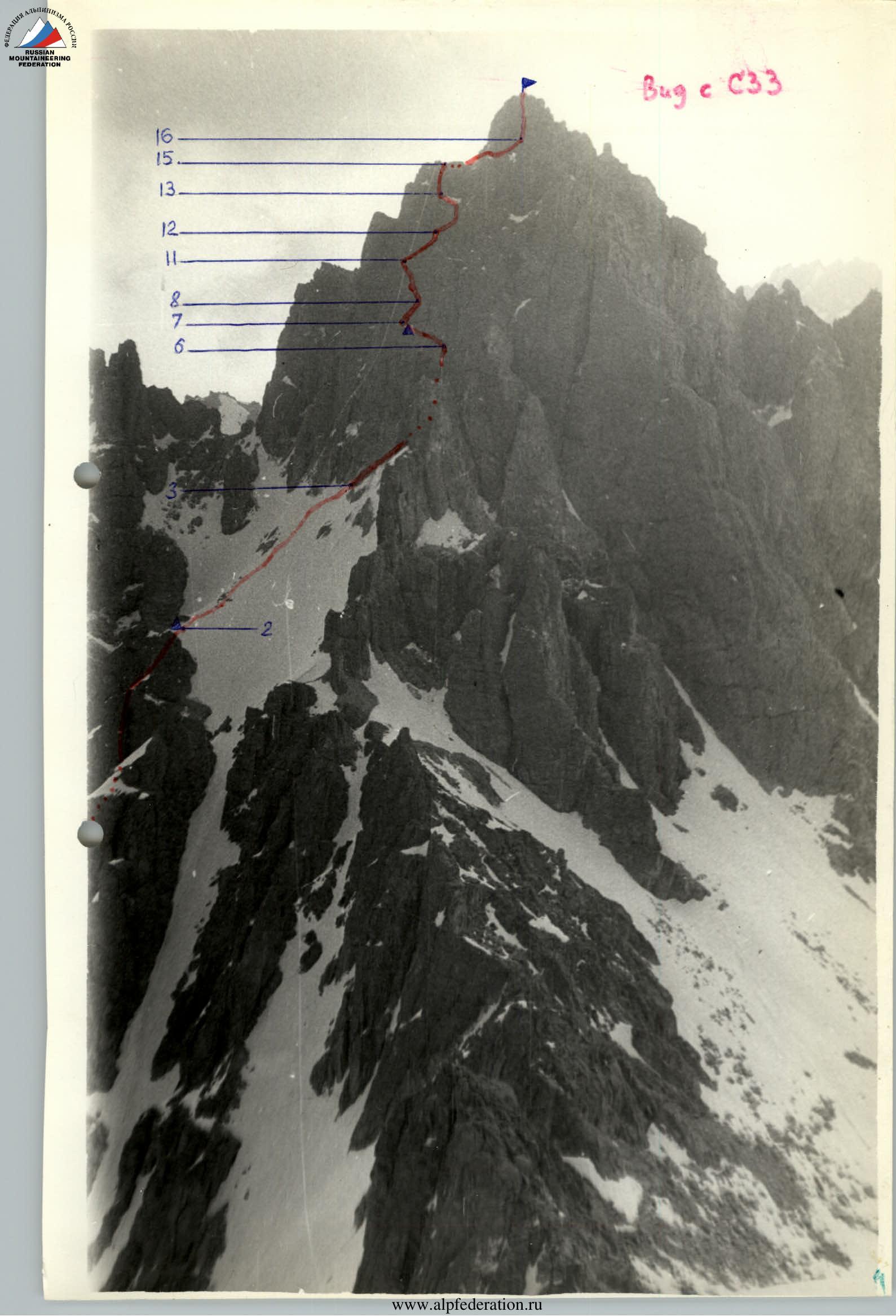
Bug with C33
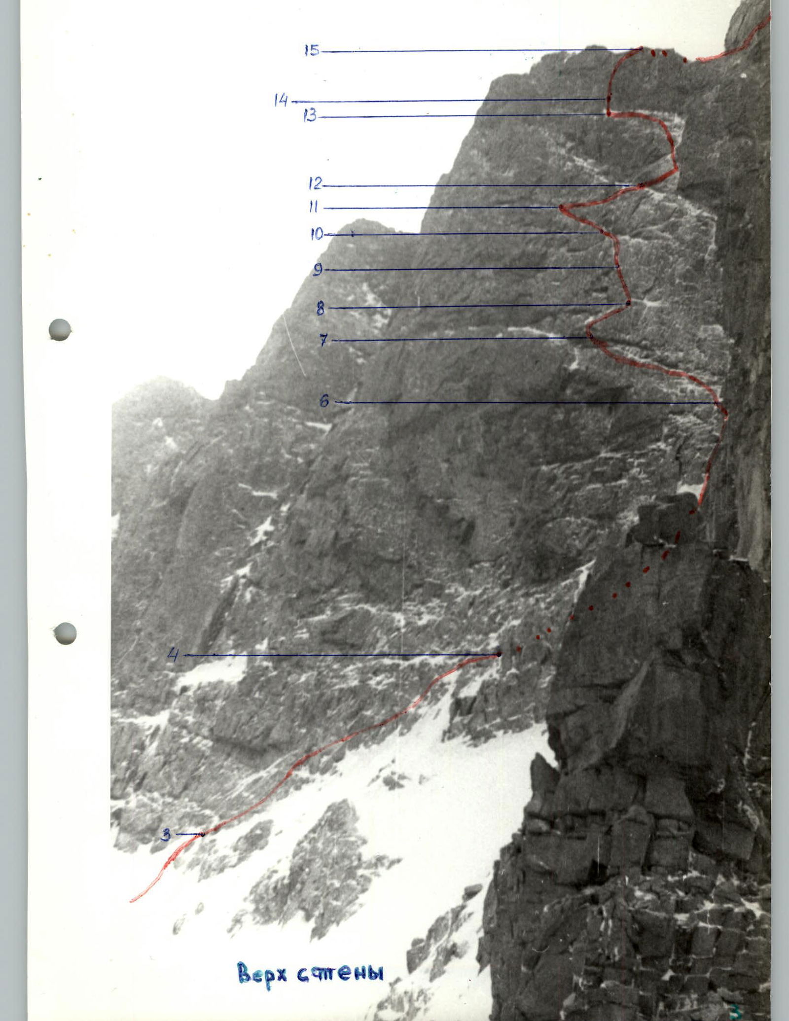
Top of the wall www.alpfederation.ru↗
Bug with CBB
DZHOLDZHILGA www.alpfederation.ru↗
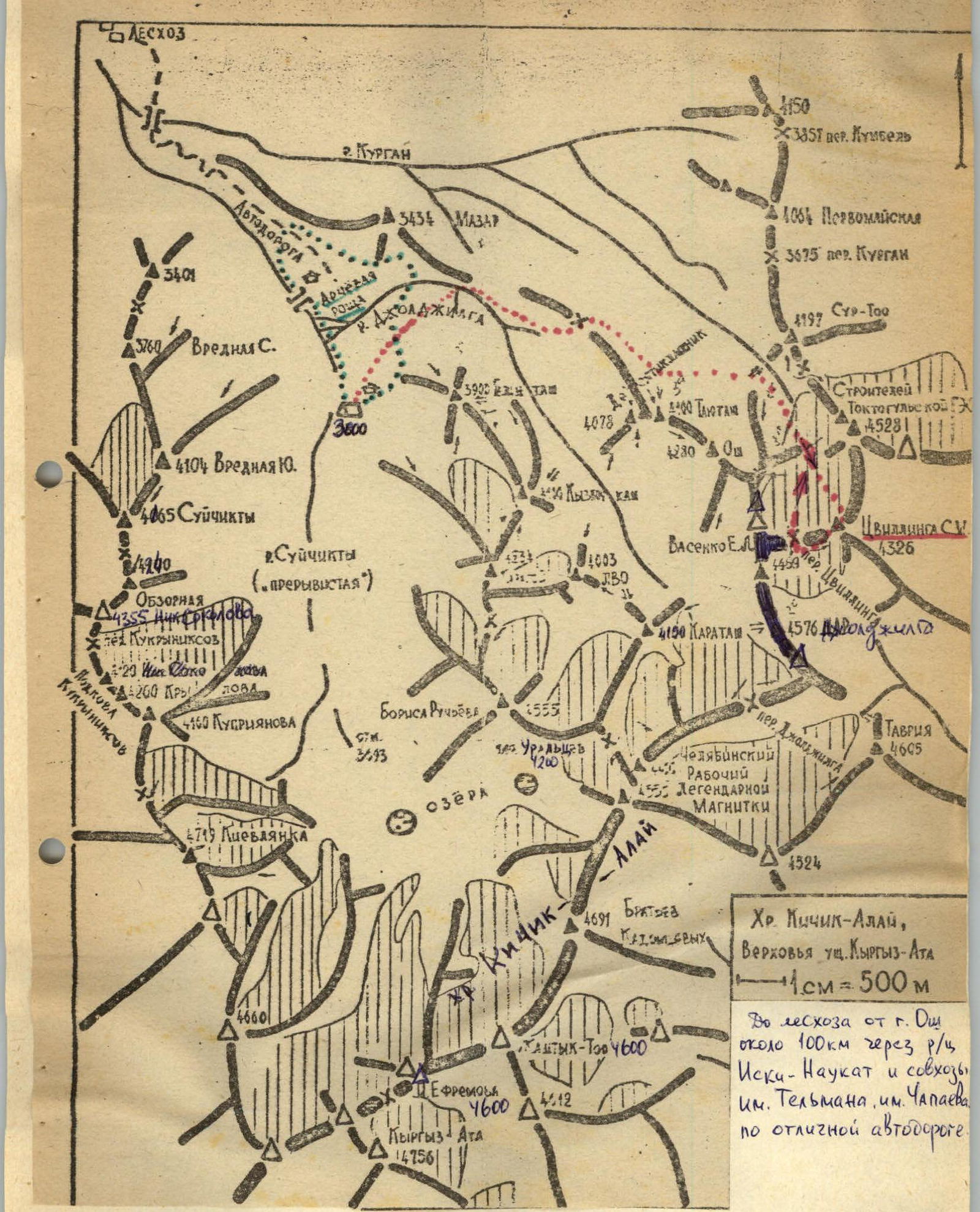
Kichik-ALAY ridge, upper reaches of the Kyrgyz-ATA gorge 1 cm = 500 m From the city of Osh to the forest area is about 100 km via the regional center Iski-Naukat and the collective farms named after Telman, Chapayev along an excellent highway.
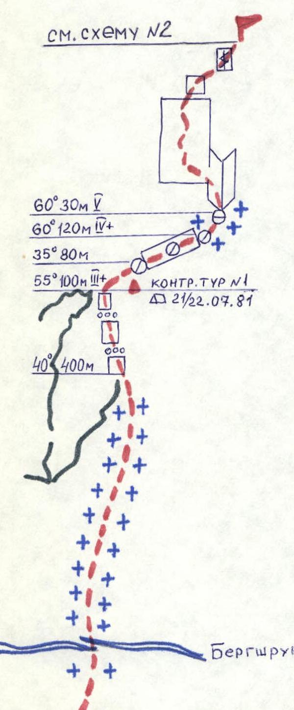
Scheme #1 Control cairn #1 21/22.07.81 www.alpfederation.ru↗
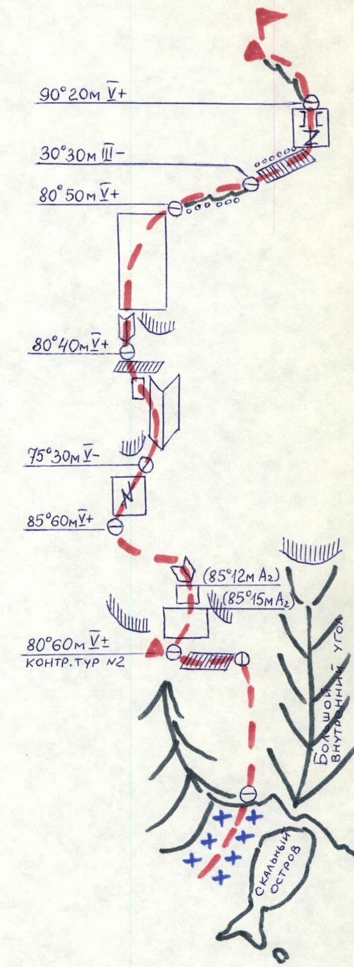
Scheme #2 Control cairn #2 www.alpfederation.ru↗
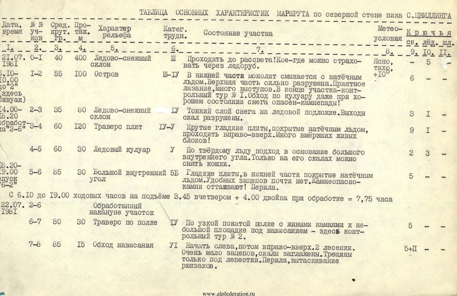
TABLE OF MAIN CHARACTERISTICS OF THE ROUTE on the north face of S. TSVILLINGA peak
| Date, time | Section # | Average steepness | Length (m) | Terrain characteristics | Difficulty category | Condition of the section | Weather conditions | Rock anchors | Ice anchors | Bolt anchors |
|---|---|---|---|---|---|---|---|---|---|---|
| 21.07.1981 | 0–1 | 40 | 400 | Ice-snow slope | 3 | Climb before dawn! In some places, you can belay with an ice axe. | Clear, calm, +10° | 5 | ||
| 5:10–10:00 (bivouac here) | 1–2 | 55 | 100 | Inselberg | 3–4 | In the lower part, the monolith is connected to the accretion ice. The upper part is heavily destroyed. Pleasant climbing, many ledges. At the end of the section — control cairn #1. Bypassing via the couloir is dangerous even with good snow conditions — rockfall! | 6 | |||
| 14:00–18:20 | 2–3 | 35 | 80 | Ice-snow slope | 4 | Thin layer of snow on ice. Rock outcrops are destroyed. | 3 | 1 | ||
| processing "2–6" | 3–4 | 60 | 120 | Traversing slabs | 4–5 | Steep, smooth slabs covered with accretion ice, climb to the right and up. Many frozen live rocks! | 9 | 1 | ||
| 4–5 | 60 | 30 | Ice couloir | 5 | On firm ice, approach the base of a large internal corner. Only on its rocks can you remove crampons. | 2 | 3 | |||
| 18:20–9:00 (descent 6–2) | 5–6 | 85 | 30 | Large internal corner | 5 | Smooth slabs, covered with accretion ice in the lower part. Few convenient handholds. Rockfall hazard — rocks are thawing! Belaying. | 5 | |||
| From 6:10 to 19:00 climbing hours on the ascent 3 hours 45 minutes for four + 4 hours 00 minutes for a pair during processing = 7 hours 45 minutes. | ||||||||||
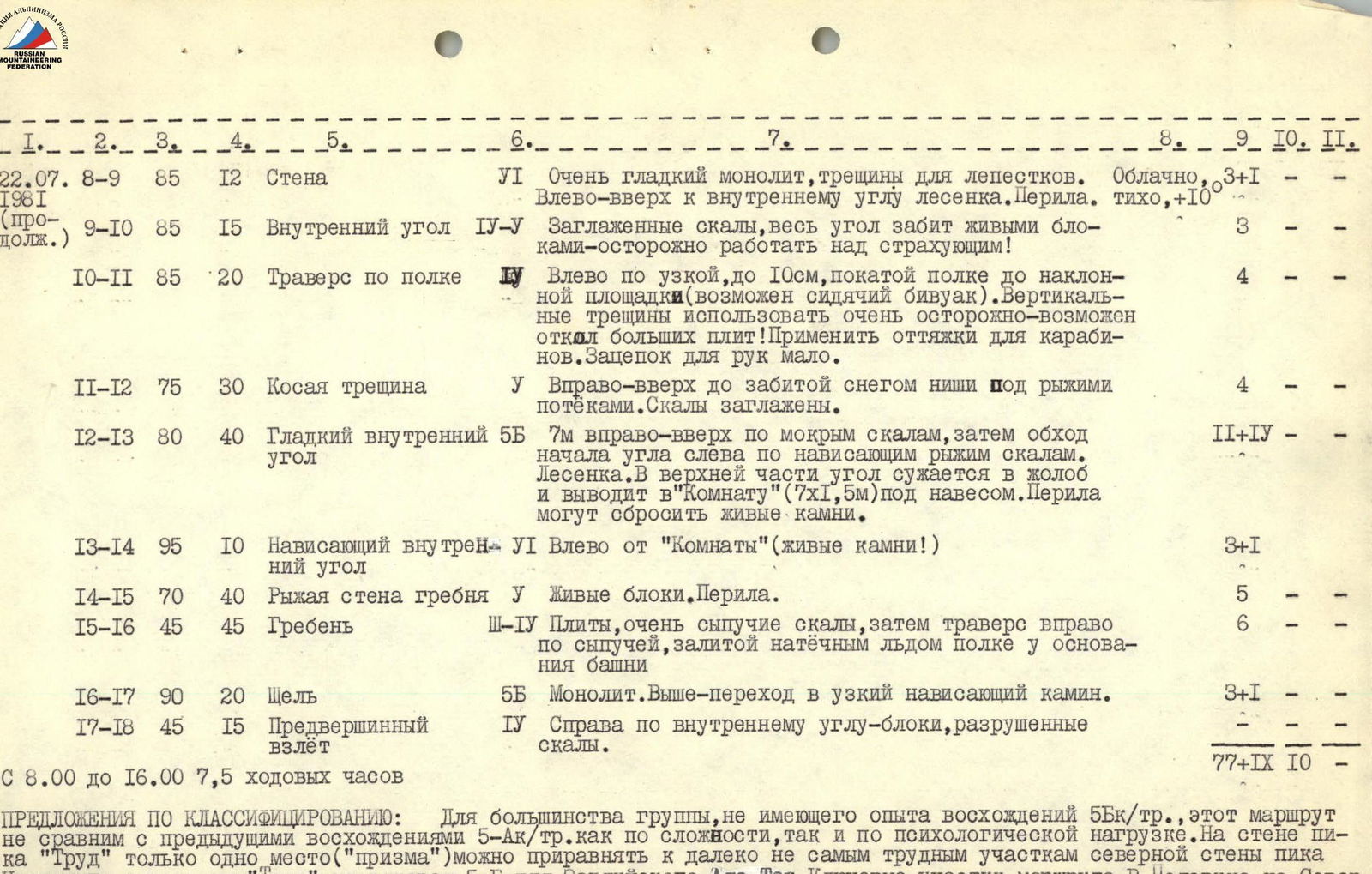
| 22.07.1981 | 6–7 | 80 | 30 | Traverse along a ledge | 4 | Along a narrow, sloping ledge with live rocks to a small site under an overhang — here is control cairn #2. | 5 | |||
| 7–8 | 85 | 15 | Bypassing an overhang | 6 | Start on the left, then to the right and up. 2 ladders. Very few handholds, rocks are smooth. Belaying, pulling up backpacks. | 5 | 2 | |||
| 8–9 | 85 | 12 | Wall | 6 | Very smooth monolith, cracks for thin blades. To the left and up, a ladder. Belaying. | Cloudy, calm, +10° | 3 | 1 | ||
| (continued) | 9–10 | 85 | 15 | Internal corner | 4–5 | Smooth rocks, the entire corner is filled with live rocks — be careful when working on belaying! | 3 | |||
| 10–11 | 85 | 20 | Traverse along a ledge | 4 | To the left along a narrow, up to 10 cm, sloping ledge to a sloping site (possible sitting bivouac). Use vertical cracks very carefully — large slabs may break off! Use slings for carabiners. Few handholds. | 4 | ||||
| 11–12 | 75 | 30 | Diagonal crack | 5 | To the right and up to a snow-filled niche under rusty streaks. Rocks are smooth. | 4 | ||||
| 12–13 | 80 | 40 | Smooth internal corner | 5 | 7 m to the right and up on wet rocks, then bypass the beginning of the corner on the left along overhanging rusty rocks. Ladder. In the upper part, the corner narrows into a groove and leads to the "Room" (7x1.5 m) under an overhang. Belaying may dislodge live rocks. | 2 | 4 | |||
| 13–14 | 95 | 10 | Overhanging internal corner | 6 | To the left of the "Room" (live rocks!) | 3 | 1 | |||
| 14–15 | 70 | 40 | Rusty wall of the ridge | 5 | Live rocks. Belaying. | 5 | ||||
| 15–16 | 45 | 45 | Ridge | 3–4 | Slabs, very loose rocks, then traverse to the right along a loose, ice-covered ledge at the base of the tower | 6 | ||||
| 16–17 | 90 | 20 | Crack | 5 | Monolith. Above — transition to a narrow, overhanging chimney. | 3 | 1 | |||
| 17–18 | 45 | 15 | Pre-summit ascent | 4 | To the right along an internal corner — blocks, destroyed rocks. | |||||
| From 8:00 to 16:00 7 hours 30 minutes of climbing hours | ||||||||||
| TOTAL | 77 | 9 | 10 |
PROPOSALS FOR CLASSIFICATION: For most of the group, without experience of ascents of 5B category, this route is not comparable to previous ascents of 5A category, both in terms of complexity and psychological load. On the wall of "Trud" peak, only one spot ("prism") can be compared to the not-too-difficult sections of the north face of TSVILLINGA peak, and yet "Trud" peak is not a routine 5B in Trans-Ili Alatau. The key sections of V. Pelevin's route on Severny Talgar are significantly easier, so the group proposes to include the route they completed in the Classification Table.
Tsvillinga S. M. peak 4326 5B comb. via the north face www.alpfederation.ru↗
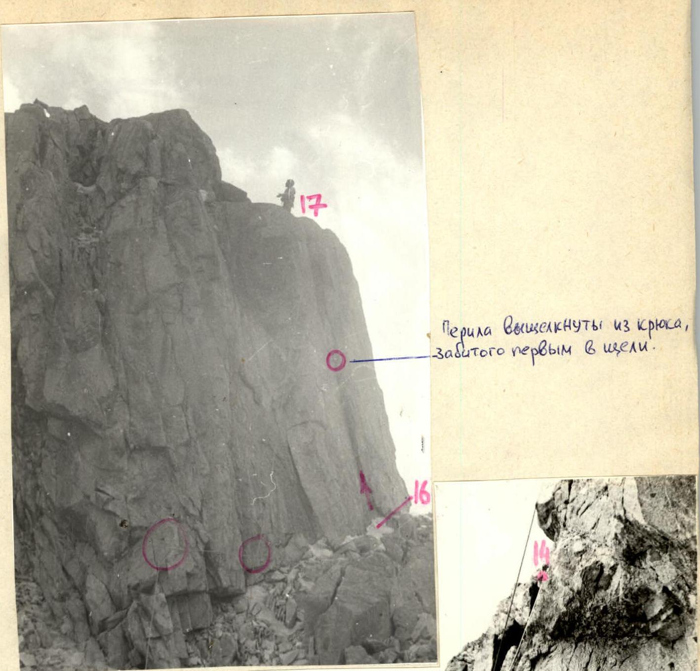
Ropes pulled out of the anchor, hammered first in the crack. www.alpfederation.ru↗