Climbing Route Descriptions
I. Peak "Sтроитель Токтогульской ГЭС" (Builder of Toktogul HPP) Kurgan
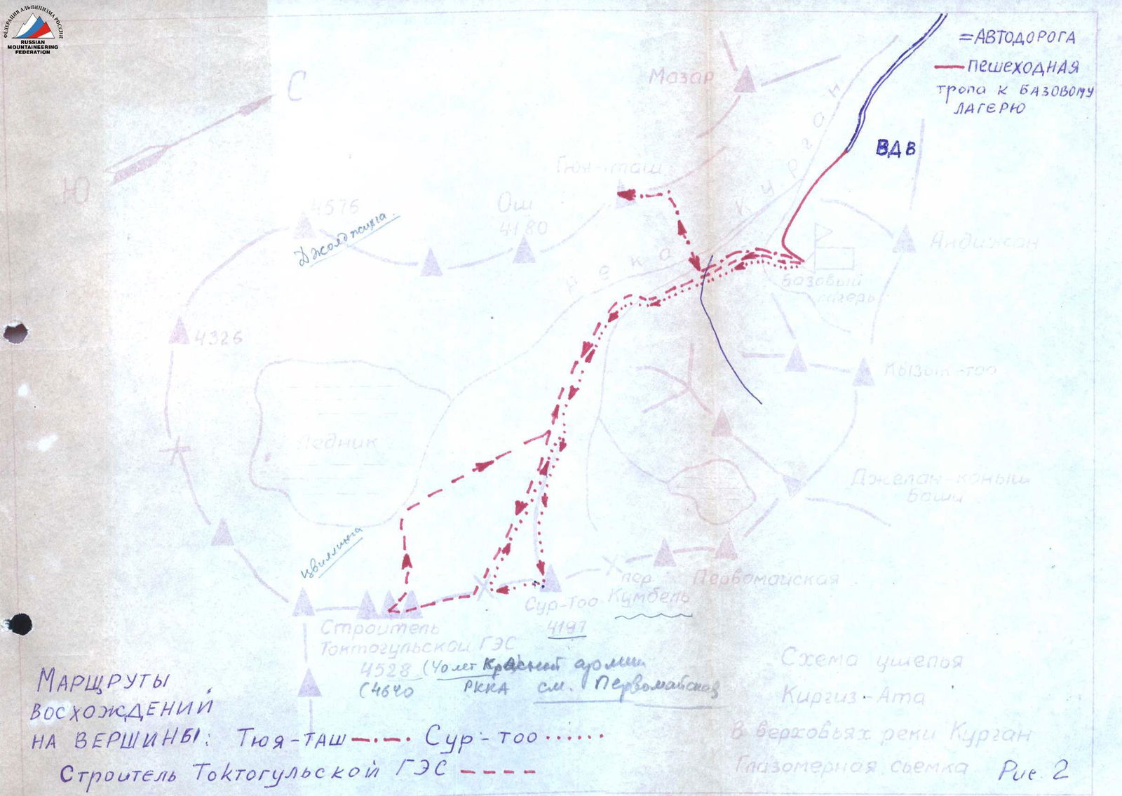
The first ascent was made by a group consisting of Koporushkin V.G. (leader), Inozemtsev Yu.P., Kuzmichenok V.A., Tonka A.R. (all - 2nd sports category) in the period November 2-4, 1972. The route diagram is shown in Fig. 2.
The mountain spur, in which the peak is located, stretches along the right bank of the Kurgan River in a north-northwest - south-southeast direction.
The overall view of the route is shown in Fig. 3 (from the side of Tyuya Tash peak) and Fig. 4 (from the side of Sur-Too peak).
Approach. From the bivouac, after crossing to the left bank of a nameless stream, we descend to the south. After 10-15 minutes of walking, we cross a stream flowing from under Dzhelan-Konybashi peak. Further, the trail goes along the right bank of the right-bank tributary of the Kurgan River (the stream originates under the Kumbel pass). After 1.5 hours of walking from the base camp, the trail crosses to the left bank of the tributary and goes along the snow-covered moraine in the direction of the southeastern ridge of Sur-Too peak (2 hours).
Route. Further movement along the ridge in the direction of the saddle between Sur-Too peak and Peak "Builder of Toktogul HPP" - initially under the cliffs, and then along the cliffs of the western slopes of the ridge.
There is a convenient place for an overnight stay on the saddle. The travel time from the base camp to the saddle is 6 hours.
From the saddle, move along the crest to the I gendarme, which is bypassed on the left in the direction of travel.
Further, we bypass the lower part of the II gendarme on the left. Then, along a snowy couloir, and in the upper part - along the cliffs with piton protection (1 piton) - we reach the crest under the III gendarme.
First, we move to the right along a ledge, and then along the crest to the second ledge, going to the right. Do not go along this ledge to the right. Move with piton protection (1 piton) to the left along an indistinctly expressed ledge, bypassing the upper part of the gendarme, with an exit to the saddle between III and IV gendarmes.
A very short saddle (3 m) to the right in the direction of travel turns into a narrow steep rocky couloir. To the left of the saddle is a steep snow-ice slope. On the saddle, there is a window formed by large stones.
From the saddle, move up to the left along snow-covered slabs with a steepness of 50-60°. Having passed one rope length with piton protection (24 pitons), move to the right to the crest under the V gendarme. This section from the saddle to this place was covered in 3 hours.
The lower part of the V gendarme is traversed head-on. Move initially along a couloir to the right of the crest with alternating protection (20 m), and further - along the crest (another half-rope length). A horizontal snow-covered section of the crest leads under the upper part of the V gendarme, which is a steep rocky outcrop.
Further, go down to the left for 10 m along the snow on the cliffs. Then, move along the crest down along the snow-covered ice slope with a subsequent ascent under the cliffs (1 rope length). Having reached a small rocky ledge (Fig. 3), drive in a piton. Continue movement along the border of rock-snow (ice) with piton protection (3 pitons) to the saddle between V and VI gendarmes.
The right part of the VI gendarme is a sheer 40-meter wall. From the saddle, move along the left part of the gendarme - a steep (50-60°) snow-ice slope. One rope length is traversed in crampons with piton protection (2 ice pitons). Further, move along the snow or snow-covered cliffs with simultaneous protection, overcoming or bypassing to the left the rocky outcrops in the crest.
Somewhat above the VI gendarme, to the right of the crest, there is a platform for one tent. The time taken to pass the section from the beginning of the V gendarme to the overnight stay was 4 hours 30 minutes.
From the overnight stay, move to the left along the snow, and then along a gentle large scree with an exit to the crest under the VII gendarme. The gendarme is bypassed on the left along a steep snowfield and ice (Fig. 6) with alternating protection through an ice axe.
At this place, in the crest, there is a rocky bastion. We move bypassing the bastion to the left through a snowy hollow to a snowy slope with a steepness of 40-50° in the direction of the peak (Fig. 7) with an exit to the cliffs of the crest.
The peak consists of three towers, the highest of which is the middle one.
The first summit tower, clearly visible in Fig. 7, is bypassed to the right in the direction of travel along ledges with an exit up to the saddle in the main crest between the first and middle summit towers.
The exit to the peak - the middle tower (Fig. 8) - with piton protection (1 piton).
Control towers are built on the first and second towers.
The travel time from the overnight stay to the peak is 3 hours 00 minutes.
4326


Fig. 3
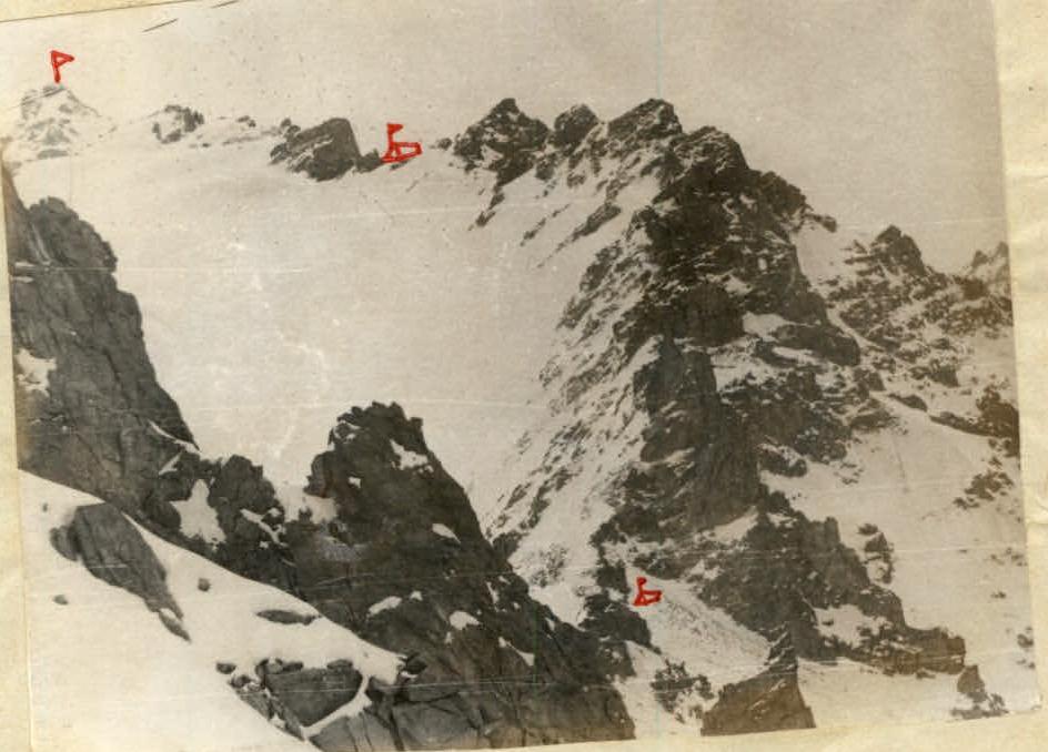
Fig. 4. Descent from the peak (Fig. 9) along the crest, departing from the first summit tower, to the southwest. Not reaching a large rocky massif, go into a couloir to the left. Move alternately for 3.5 rope lengths to an icy gorge. At this place, 12 m of ice is traversed in crampons with piton protection (3 rock pitons). After another rope length of movement along the snow with alternating protection, we approach the second icy section, which is overcome with piton protection (2 rock pitons). Further, move with alternating, sometimes simultaneous protection, to the moraine. The descent from the summit tower to the moraine took 3 hours 00 minutes.
16 rock pitons and 2 ice pitons were driven on the route. Four rock pitons were left on the descent when passing icy sections.
Group Equipment
- Rope 40 m - 2 pcs.
- Rock hammers - 3 pcs.
- Carabiners - 10 pcs.
- Rock pitons - 10 pcs.
- Ice pitons - 2 pcs.
- Tent - 1 pc.
- Primus stove - 1 pc.
- Crampons - 4 pairs.
Time Expenditure
First day (February 2, 1972): transition from the base camp to the saddle between Sur-Too peak and Peak "Builder of Toktogul HPP" - 6 hours.
Second day (February 3, 1972): movement along the route - 7 hours 30 minutes.
Third day (February 4, 1972):
- ascent to the peak - 3 hours 00 minutes,
- descent to the moraine - 3 hours 00 minutes,
- movement to the base camp - 2 hours 30 minutes.
Recommendation. The length of the route, the presence of complex rocky and steep snow-ice sections, where there may be even more ice in the summer, allows us to recommend classifying this route as 4A category of difficulty.
The route passed in terms of complexity, diversity, and length, in our opinion, is not inferior to the routes of 4A category of difficulty to the peaks Boks (Ala-Archa alpine camp) and Ak-Tash (Dugoba alpine camp).

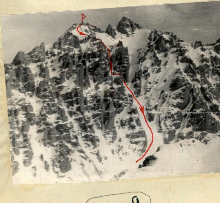
Fig. 9


