PHOTO #1: General view of Peak ZATO (taken on July 20, 2007 from the slopes of Peak B.Ruchyev, alt. 4300 m)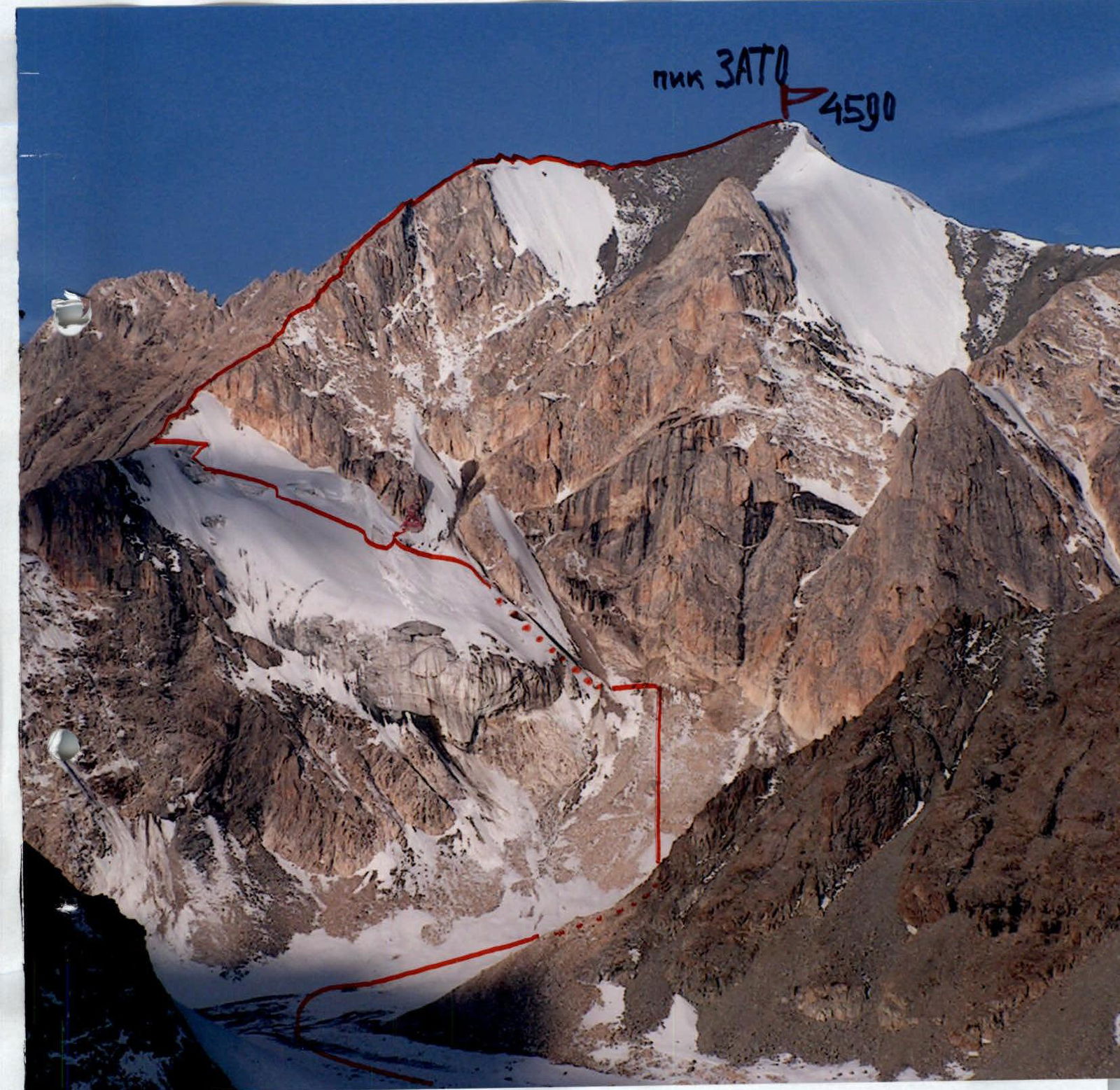
Passport
5.1.4. Kichik-Alay ridge, Suichikty valley
Peak ZATO 4590 m, north to east ridge, first ascent
Proposed: category 3A. Route type: combined
(Note: "ZATO" stands for a closed administrative-territorial formation of the Ministry of Atomic Energy)
Height difference according to the group's altimeter — 590 m, including:
- north slope — 380 m
- east ridge — 210 m
Route length — 1400 m (estimated), including: category III difficulty — about 570 m at 30° and above. Average steepness of the entire route — 34°, including:
- north slope — 38°
- east ridge — 30°
On the ascent, used for belaying:
- ice screws — 7 (excluding outcrops)
- chocks and rock pitons — 11 No aid climbing; no belay points left behind
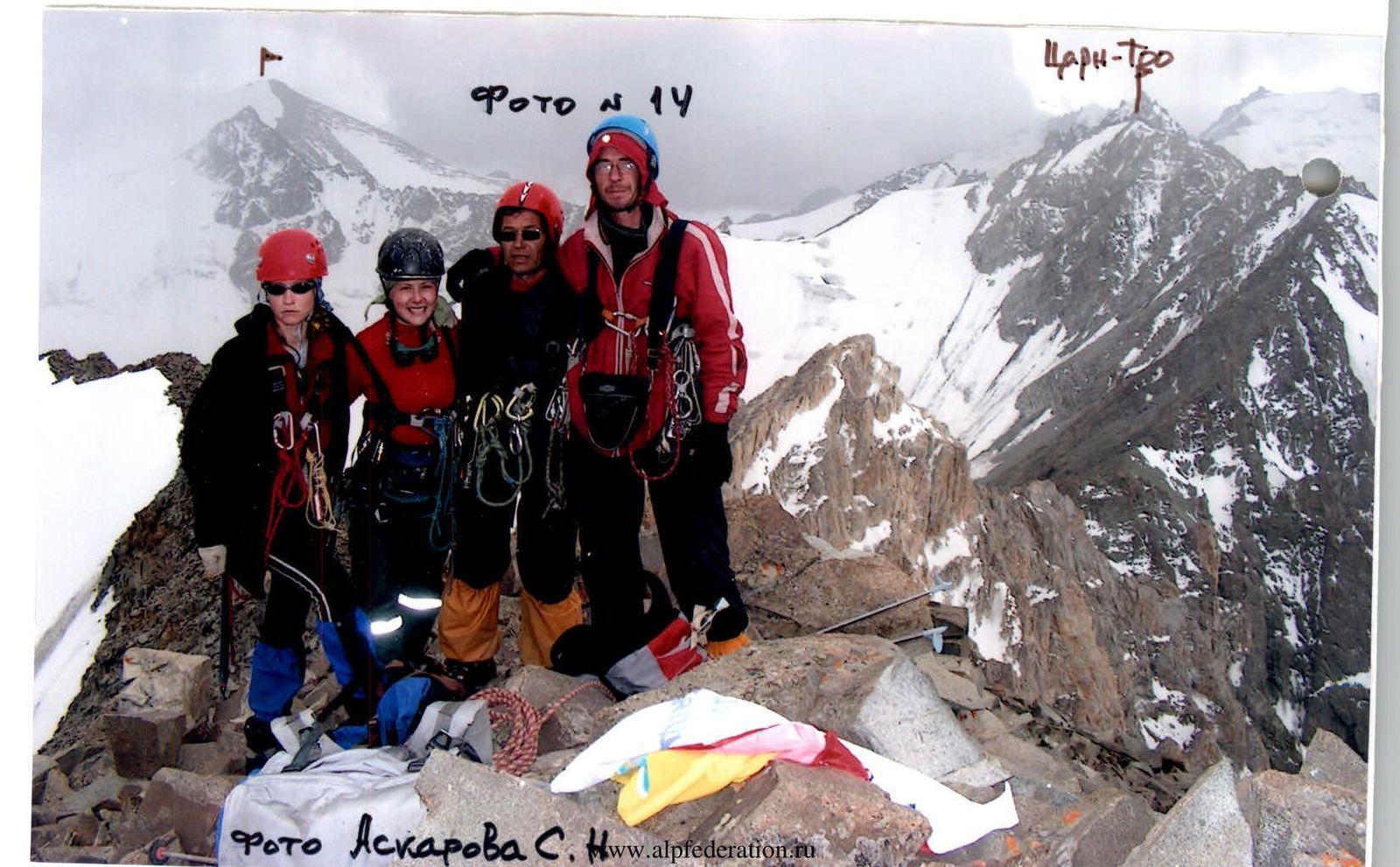
Leader: Askarov Samat Nurmukhametovich (CMS, 2nd sports category) — Trehgorny (ZATO Chelyabinsk region) Participants:
- Anokhin Anatoly Nikolaevich (3rd sports category+) — Ozersk (ZATO Chelyabinsk region)
- Bushuev Yuri Nikolaevich (3rd sports category+) — Ozersk (ZATO Chelyabinsk region)
- Modestova Nadezhda Vladimirovna (2nd sports category+) — Snezhinsk (ZATO Chelyabinsk region)
- Smagina Varvara Alexandrovna (3rd sports category+) — Ozersk (ZATO Chelyabinsk region)
Senior coach: Levin Mikhail Semenovich, Master of Sports of the USSR (category III, no. 36) — Chelyabinsk
Climbing hours/days on the route: 7.0 / 1 Time from base camp (3000 m) to the summit: 12.5 / 2 (with descent — 17.5 / 2)
July 31, 2007:
- from base camp (3000 m) to bivouac by the lake (3700 m) — 3.5 hours (from 10:00 to 13:30)
August 1, 2007:
- from bivouac to the start of the route (4000 m) — 2.0 hours (from 3:00 to 5:00)
- from the start of the route to the saddle (4380 m) — 4.0 hours (from 5:30 to 9:30)
- from the saddle to the summit — 3.0 hours (from 10:00 to 13:00)
Necessary explanation
From 1975 to 1984, the upper reaches of the Kyrgyz-Ata valley were developed by the Chelyabinsk regional courses of higher mountaineering skills, established in 1972 by Mikhail Levin, Master of Sports. He was assisted by:
- G.K. Rozhalskaya, Master of Sports of the USSR International Class;
- M.F. Levina, Master of Sports;
- V.I. Mironov, Master of Sports;
- A.B. Nelidov, Master of Sports;
- V.G. Tarkhanov, Master of Sports;
- V.G. Mironov, Candidate for Master of Sports;
- N.P. Yakovleva, Candidate for Master of Sports; and others.
According to existing traditions, mountaineering instructors gave names to the peaks:
- after Soviet leaders (Vasenko, Kadomtsev, etc.);
- writers and artists (I. Efremov, B. Ruchyev, Kukryniksy);
- "Legendary Magnitka";
- the newspaper "Chelyabinsky Rabochy"; and so on.
To prepare a guidebook for the Kichik-Alay ridge, Chelyabinsk mountaineers provided A.F. Naumov with a map corrected by M.S. Levin and N.V. Averina, as well as:
- hundreds of photos and photopanoramas;
- dozens of descriptions of first ascents and first traverses.
Unfortunately, he did not always handle the proposed peak names correctly: for example, introducing names like "Kukryniksy — West" or even more absurd ones like "Kievlanka — South".
To mark the upcoming 70th anniversary of the Djailyk alpine camp and the 60th anniversary of the launch of the first nuclear reactor in Chelyabinsk-40 (now Ozersk) in 2008, M.S. Levin planned a first ascent for our team on the previously unclimbed peak 4590 m (south of Peak Kievlanka) in 2007.
The team was organized by veteran mountaineers from the Chelyabinsk region, our instructors: S.A. Morozov worked at "Djailyk" in 1961–1964, M.S. Levin — in 1963, 1971, 1987–1988, 1990–1991, and S.N. Askarov worked there for several years. They introduced many generations of mountaineers living and working in ZATO — closed administrative-territorial formations of the Ministry of Atomic Energy — to mountaineering.
“Let's part with Cheget until summer, so piercingly white…”
A mountain is a God; those who believe have an easier time living! Let's part until summer… but this is the body that is being said goodbye to, — the soul remains to forever circle over Djailyk…
Route profile (view from the right)
Photo #2(1): taken on August 8, 2007 from the summit of Peak Kievlanka 4719 m
Photo #2(2): taken in August 1977 from the summit of Peak Kievlanka 4719 m
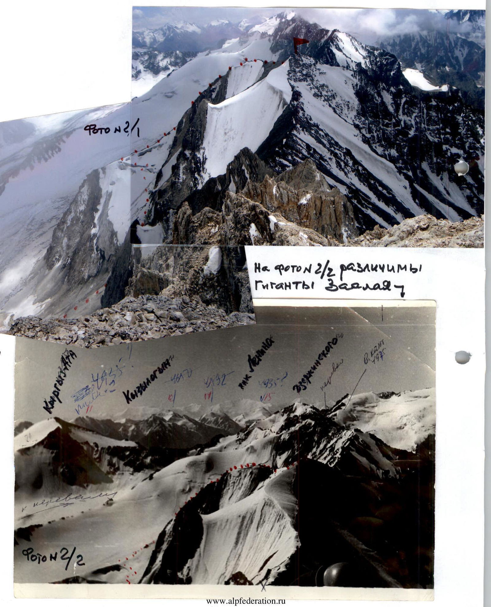 The Giants of Zaalai are visible on photo 2(2).
Hand-drawn route profile (scale 1 mm = 3 m)
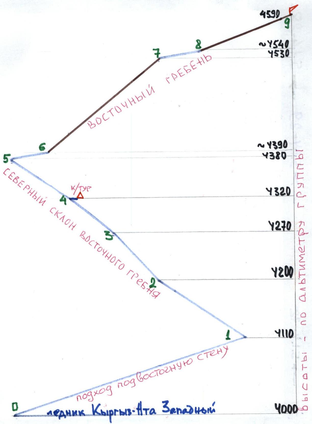
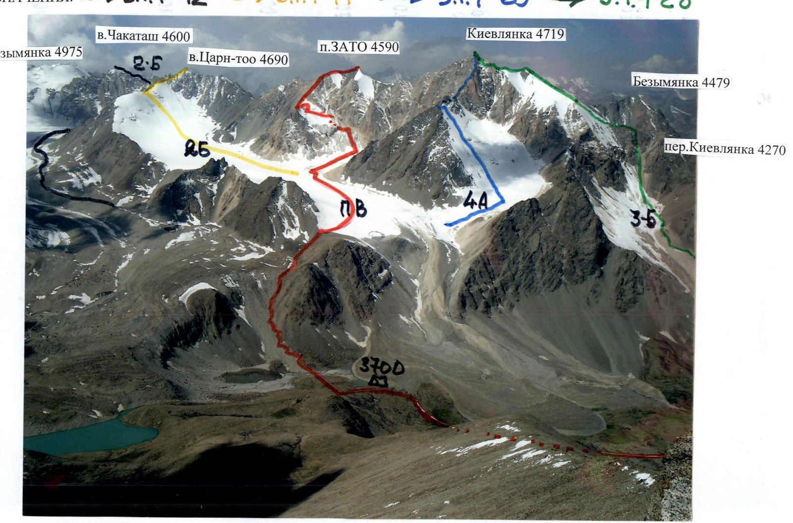
Photo #3: Photopanorama of the area (taken on July 20, 2007 from under the summit of Peak B.Ruchyev 4300 m)
Conventional symbols:
5.1.4-72 → 5.1.4-71 → 5.1.4-29 → 5.1.4-28
Map. Scale 1 cm = 500 m
— photo shooting points from Peak B. Ruchyev;
— photo shooting points from the summit of Kievlanka.
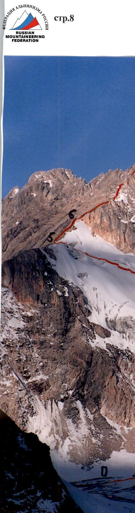
Photo #4: Technical photo (taken on July 20, 2007 from the slopes of Peak B.Ruchyev, alt. 4300 m)
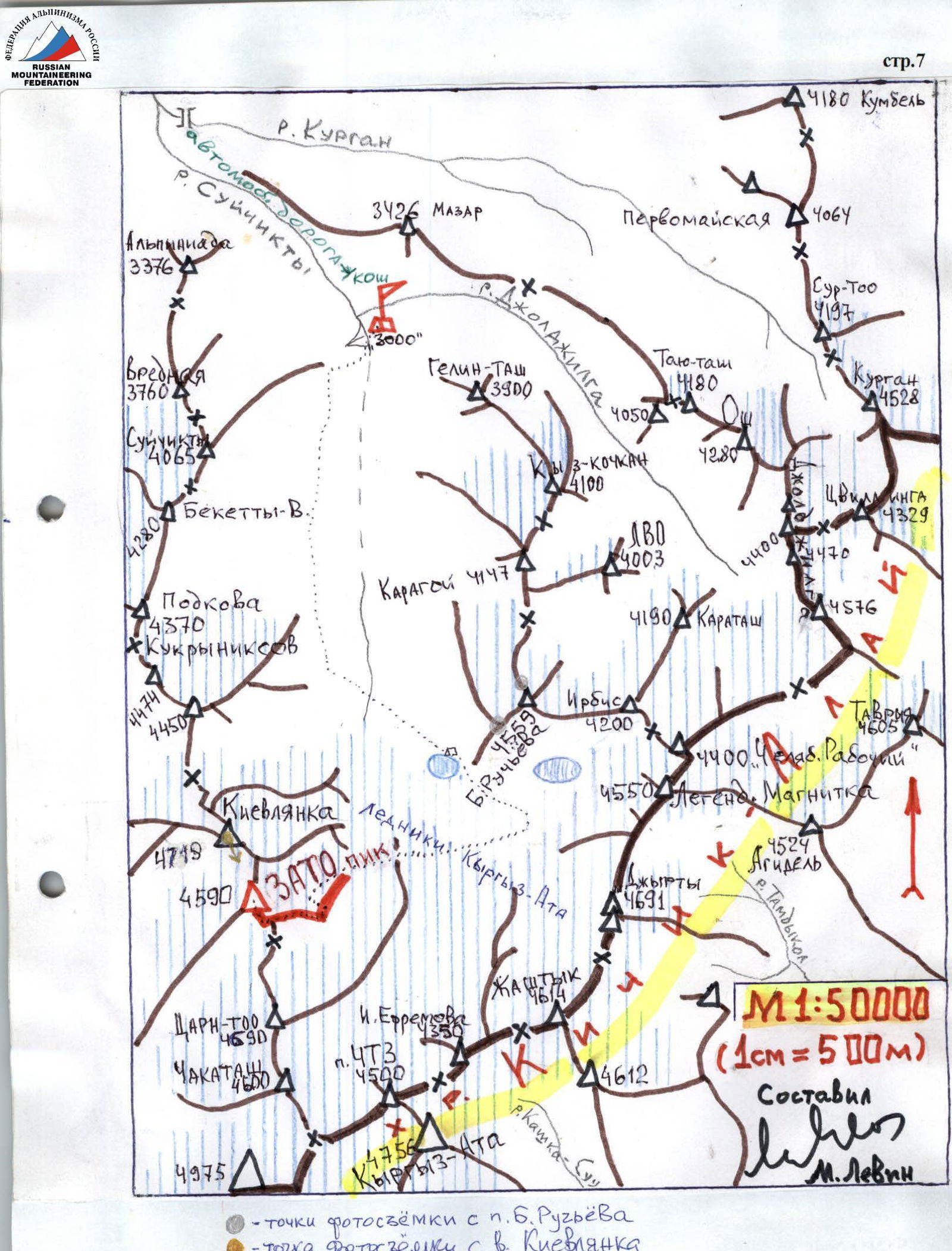
Table of main characteristics in UIAA symbols
| Section | Belay: number of points, type | Brief description of the section | UIAA symbol | Category | Length, m | Steepness, ° |
|---|---|---|---|---|---|---|
| Scale: 1 mm = about 6 m | ||||||
| 13:00 | Summit area 4590 m | |||||
| R8–R9 | Simultaneously on the whole rope | Destroyed pre-summit ascent (photo #9) | П | about 150 | up to 25 | |
| R7–R8 | Simultaneously on the whole rope | Upper snow-ice saddle with a cornice and two rock formations (photo #9) 4540 m | П | about 70 | about 10 | |
| R6–R7 | Alternately, 20–30 m, through reliable outcrops; also using handrails — 9 chocks, 2 pitons; where possible — simultaneously through outcrops | Jagged rocky east ridge (photo #4, 11) | П–Ш | at least 230 | up to 60; avg. 40 | |
| 9:30 | Simultaneously in teams, without crampons | Lower, almost horizontal saddle on the east ridge (photo #4, 12) | 1 | about 100 | <10 | |
| R4–R5 | Alternately through ice screws, sometimes using handrails | Snow-ice north slope under the saddle — closed crevasses!!! (photo #4, 7, 8) Control cairn on rocks 4320 m | Ш | zigzags about 130 | up to 35 | |
| 7:30 | Alternately through ice screws, using handrails | Departure from the snow-ice couloir through a bergschrund to the left-upwards towards the bottom of rocks, zigzagging among closed crevasses (photo #4) 4270 m | Ш | about 110 | 35 | |
| R2–R3 | 7 ice screws, only occasionally through an ice screw | Bypassing the ice fall to the right on ice and snow, above the gully (photo #6) | Ш | 100 | up to 45 | |
| R1–R2 | Simultaneously and very carefully! | Ice and frozen scree on rocks resembling "ram's foreheads" (photo #4, 5) | Ш | about 150 | up to 35 | |
| R0–R1 | Simultaneously in teams, with crampons | Snow-ice slope with embedded stones (photo #4) | 1 | about 360 | up to 20 | |
| 5:30 | 4000 m |
Brief description
A) Approach
Private "minivans" and jeeps from the Osh bus station are frightened by the dilapidated bridge over the Kuragan river and refuse to take the so-called "motor road" along the steep stony ascent beyond the bridge.
To avoid carrying all the gear from the bridge (7 km, 400 m ascent), upon arrival in Osh, one should immediately send a messenger without a backpack to Iski-Naukat on a regular bus to find the house in the Telman sovkhoz village, two blocks away from the new school, where Sharip-bek's father lives, the driver of the GAZ-53. From June 15 to the end of September, Sharip almost daily transports goods across the dilapidated bridge: livestock, or tourists to the sacred mountain Mazār and the Suichikty springs, right opposite which there are campsites. From his house to the lower forest boundary (30 km), he can take 15 people with backpacks; the evacuation from the forest boundary down to the Osh stadium (about 70 km) cost us 1700 rubles.
At the internodal site, where there is a stone incomplete construction near Aman's yurt, both motorcycles and daredevil "Zhiguli" drivers' paths end. Cow tracks from here lead through the juniper forest down to the confluence of Suichikty and Dzhol-dzhilgi. After fording Dzhol-dzhilgi across the stones:
- the first large clearing is equipped by Chelyabinsk mountaineers in 1977 as a base camp "3000 m";
- unfortunately, it is now used for grazing livestock (the Kyrgyz are living well!).
B) Hike
Up the Suichikty valley, along the left or right bank trails to the left edge of the large terminal moraine blocking the valley (3–4 hours, with a lake at 3700 m).
From here, early in the morning, ascend the moraines upwards and to the right towards the flat Kyrgyz-Ata-Western glacier. Cross the glacier and at an altitude of 4000 m, enter the lateral cirque — "courtyard number four", sandwiched between two eastern ridges:
- the right one — from Peak Kievlanka;
- the left one — from the ascent objective. The nighttime transition from the lake takes at least 2 hours.
C) Work in "courtyard #4"
With crampons, gain height while avoiding the hanging ice fall on the north, above which a snow-ice, almost horizontal saddle "4380 m" is visible on the east ridge.
To reach it, one should bypass the ice fall to the right with piton belay — do not enter the ice-gouged gully! From the snow-ice couloir (morning rockfall danger!), move up and left through the bergschrund and closed crevasses, heading towards the rocky rib (2 hours from the start of the route; there is a control cairn in the lower left part of the rocks).
The height difference on the north slope from the cairn to the middle part of the saddle is no more than 100 m, but the abundance of closed crevasses forces another 2 hours of diagonal ascent with careful belaying. Total time from the start of bypassing the ice fall to the saddle — 4 hours.
Beyond the saddle, there is a rocky ascent with rock formations; pass it either directly or from the left, as snow accumulates on the right in the beginning of the season, forming snowdrifts and cornices.
Beyond the ascent, there is a snow-ice corniced ridge at the junction of the east ridge with the south ridge; the continuation along the south ridge to the summit is uncomplicated (from the "4380 m" saddle — 3 hours).
Descent along the south ridge into the couloir at the junction of the ridges, and then down to the entrance to one of the eastern scree couloirs, if it is visible all the way down.
Recommendations on safety assessment and route passage specifics
The following sections are particularly hazardous on the route:
-
On the approach — slippery snow-covered scree (large scree, similar to the approaches in the Shkheldy valley). At 3 am, one should step "not on the white".
-
On section R1–R2 — stones embedded in ice are clearly visible in the dark, but to hurry away from the ice fall, one must carefully watch where they step with their crampons and be prepared for self-arrest in case of a fall.
-
The ice fall — is bypassed on a double-slope incline, and upon slipping, one can end up on the axis of the couloir in an ice-gouged gully — a fall is mortally dangerous; piton belay is mandatory!
-
After bypassing the ice fall, when moving left towards the bergschrund — glance upwards along the couloir: the sun soon illuminates the rocks of the east ridge, possibly causing individual stones to fall!
-
On sections R3–R4 and R4–R5 — numerous ice crevasses under deep snow; release the leader on the whole rope! Be cautious that several people, walking in a line, might end up over the same closed crevasse. _ Note: we rejected the ascent from the control cairn along the rocky rib due to numerous loose boulders, as self-belay and belay are unreliable._
-
On the R6–R7 ridge — in early July, be aware of cornices and snowdrifts hanging to the north.
-
In case of sudden weather deterioration — organize a descent from the east ridge anywhere to the south, not forgetting that there are not only "live rocks" but also rock precipices.
The number of participants in the group should not exceed 6. The initial bivouac is at the lake at 3700 m (departure no later than 3 am) or at the entrance to the 4th "courtyard" at 4000 m (departure no later than 5 am).
Recommendations on equipment usage
The group had:
- 8 titanium ice screws;
- a set of chocks;
- 10 different rock pitons. This was entirely sufficient. For emergency descent, they took rappel rings.
Conclusion
In the group's opinion, the route is definitely more challenging than the category 2B route to Peak Profsoyuzov 4100 m in the Shkheldy massif — both have a tense snow-ice beginning, but Peak ZATO adds an extended and interesting rocky ridge!
Category 3A routes, such as the north route to Peak Pogrebetskogo (7.2) or the west route along the south ridge to Peak Skryabina (7.4), seem simpler to us than the first ascent objective.
We believe that the route to Peak ZATO is on par with a classic combined "category-A three" like "Free Spain" along the western ridge.
Photos of the most interesting sections of the route
Photo #5
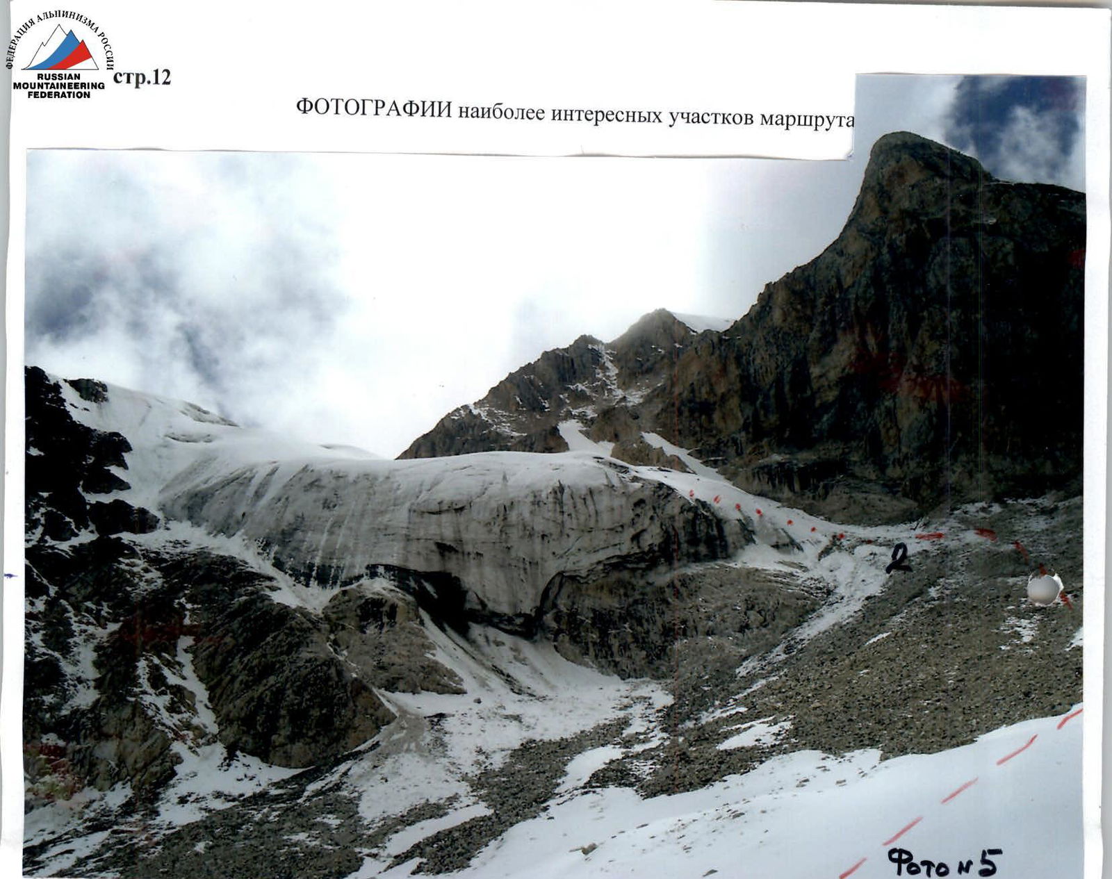
Photo #7. Approach to the future control cairn
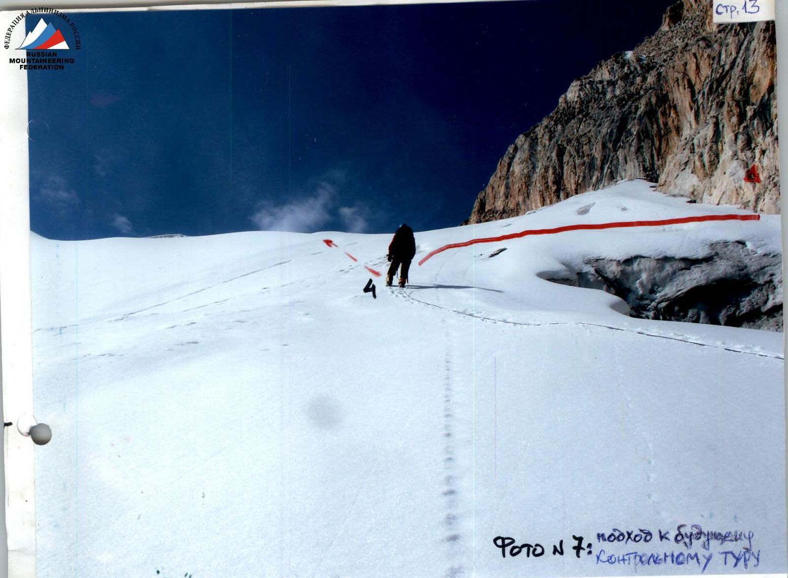
Photo #8 (taken after 4 hours)
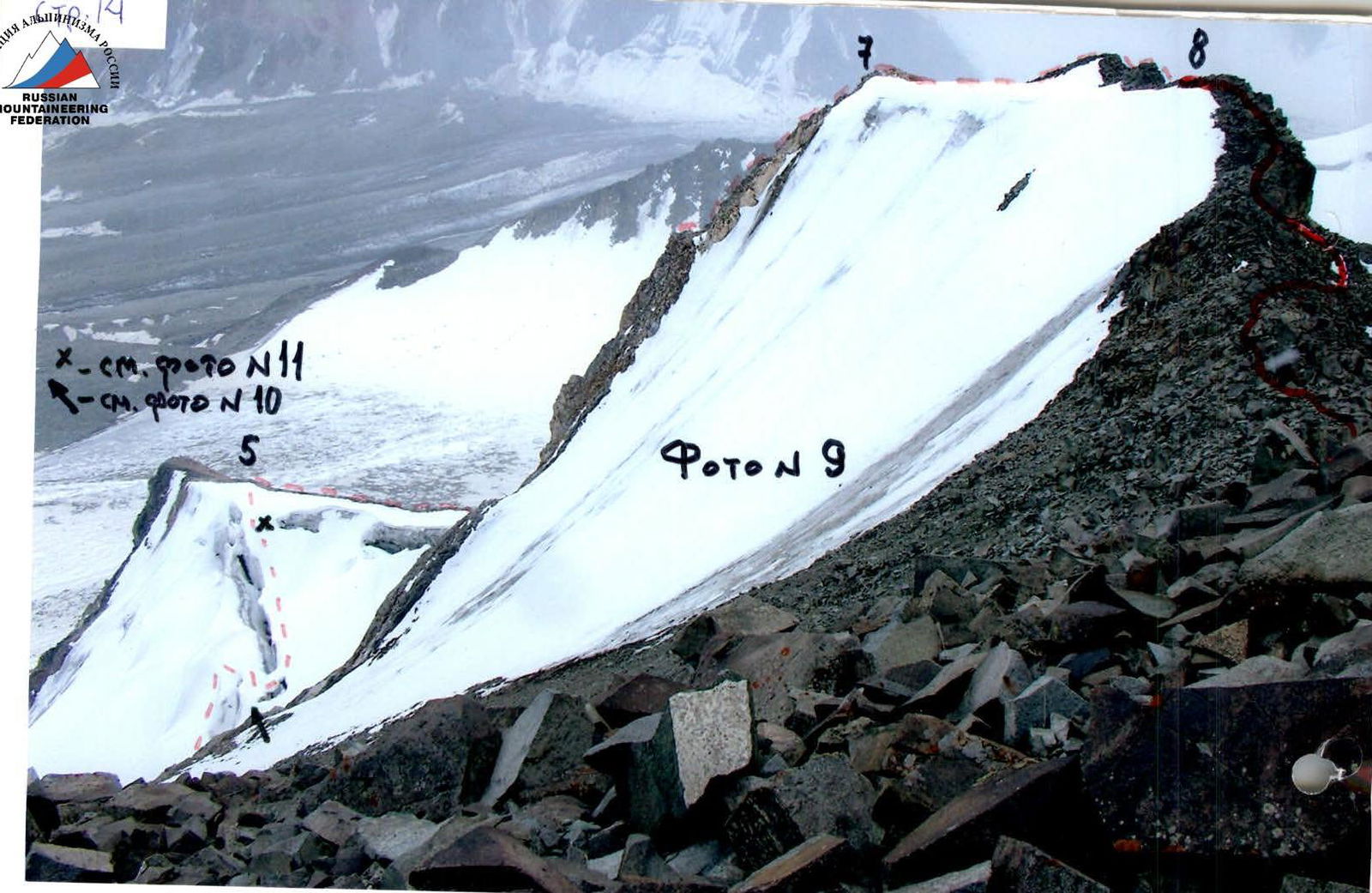
Photo #9
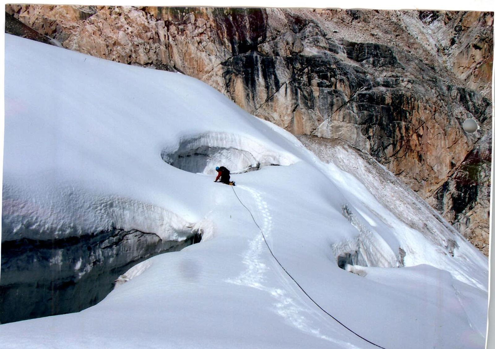
Photo #10 (see Photo #9)
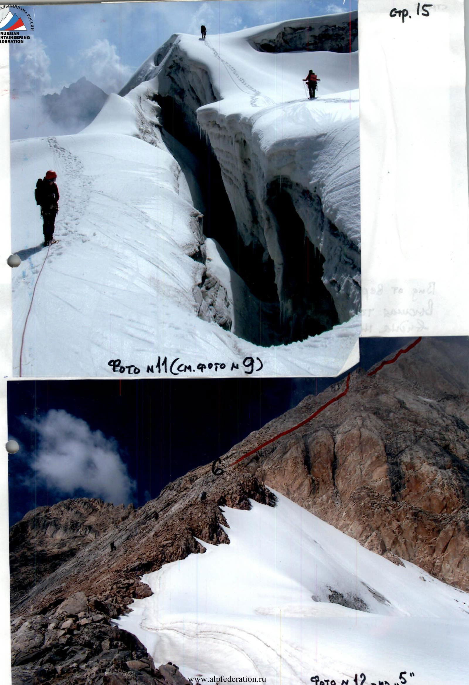
Photo #11 (see Photo #9)
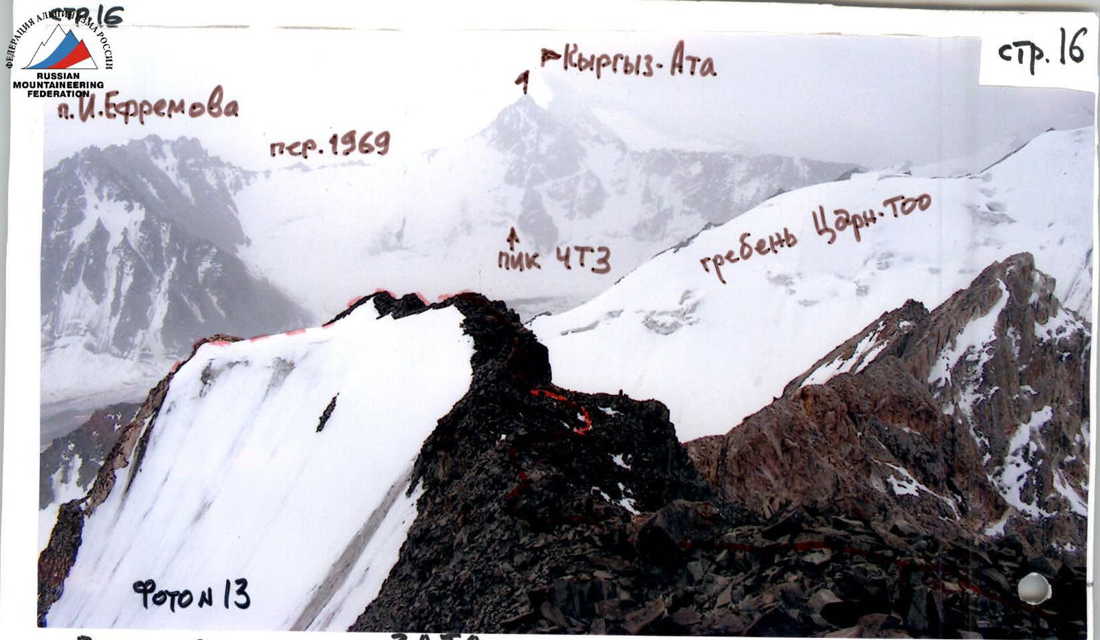
Photo #12
View from the summit of Peak ZATO. The highest point of the valley — Peak Kyrgyz-Ata 4756 m — is more clearly visible on the lower photo.
Postcard
From whom
Counterfeiting state postal payment marks is prosecuted by law
To: Levin Mikhail Semenovich
Address: ul. Kyshtymskaya, 17, apt. 12
Postal code: 454084