
ASCENT PASS.
- Ascent category: high-altitude and technical.
- Ascent area: Alay mountain range.
- Peak, its height, ascent route: Gaumysh peak, 5367 m via the spur on the north face p. 5100.
- Estimated category of difficulty: 5B.
- Characteristics of the wall section of the route: height difference — 1300 m; length of sections with 5–6 category of difficulty — 850 m; average steepness of the wall — 60°.
- Pitons used: rock — 52, ice — 80, chocks — 4.
- Total hours of climbing — 52.
- Number of bivouacs and their characteristics: 1 — lying on a snow-ice slope; 2 — lying on a snow-ice ridge; 3 — lying on a snow-ice crest; 4 — lying in a hollow on a ridge.
- Full name of the team leader, participants, and their qualification: 1. Kolobaev S. P. — CMS — captain,
- Zhurzdin V. I. — MS,
- Kukushkin A. F. — CMS,
- Shchegolev Yu. K. — CMS,
- Shatilov V. N. — CMS.
- Team coach — Zhurzdin V. I. — MS.
- Date of departure and return: July 13 – July 18, 1982.
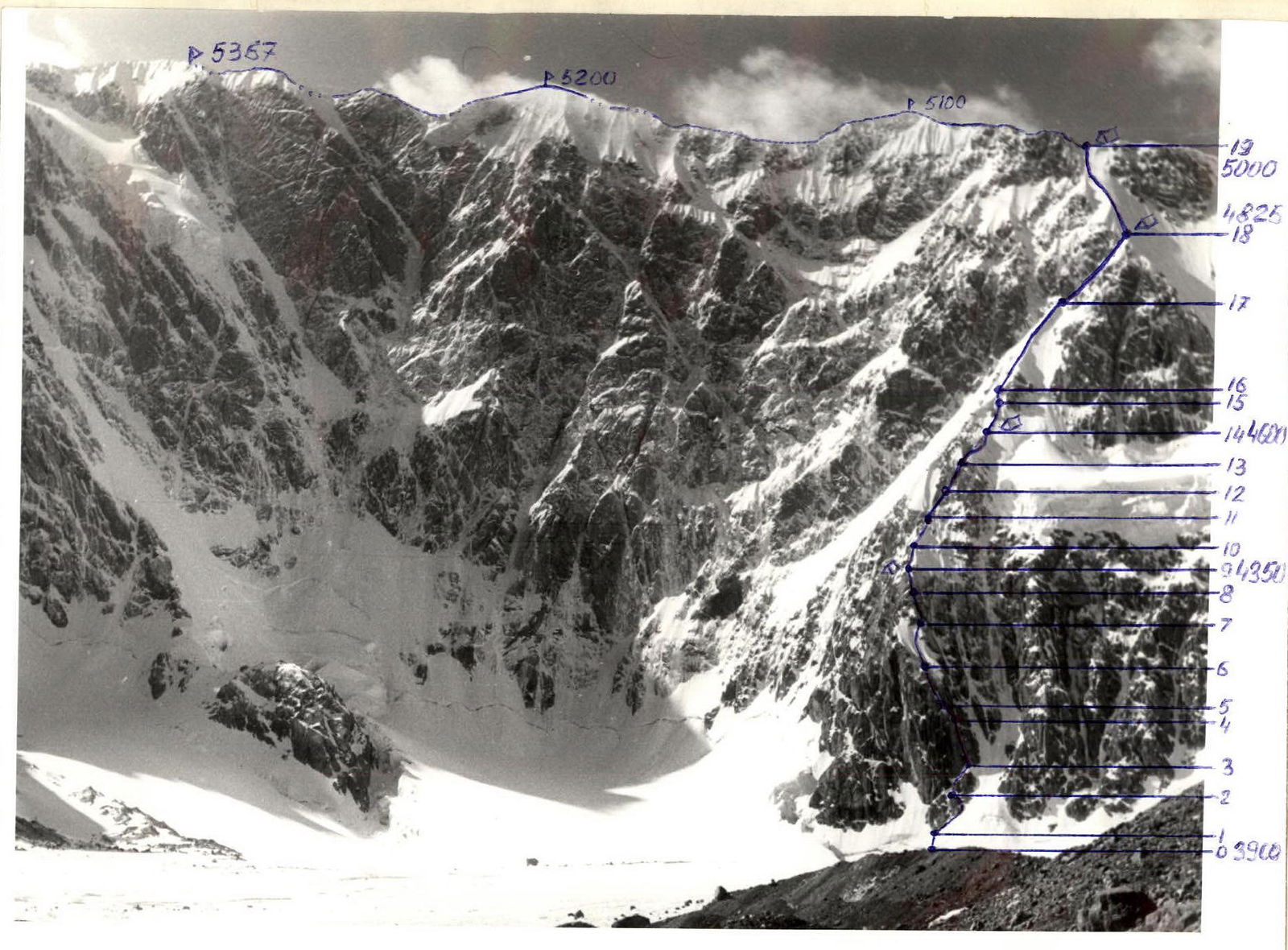 Table of the main characteristics of the route.

ROUTE DESCRIPTION
From the assault camp at the last outlet of the left-bank moraine of N. Gaumysh glacier to the start of the route is 20 minutes.
Via a snow slope through the bergschrund to the base of the lower rock bastion of the spur. The rocks are heavily fragmented, needle-like, and covered with ice. Via an oblique snow-ice ledge going to the right, we reach the start of a wide ice-filled chimney. The chimney is 80 m long. The walls of the chimney are smooth with few cracks, making climbing very difficult.
The chimney leads to an interior angle filled with a thin layer of ice. Then via a wide ice couloir to a large snow-ice patch.
Up and to the right across it to the base of an ice couloir with an ice plug in the middle. Two ropes via the ice couloir and a wide steep chimney.
Via heavily snowed, fragmented rocks to a snow-ice spur with 3–5 m rock outcrops. A bivouac is possible.
Then via the spur we reach two grey pinnacles, visible from below. Between them is an ice slope with fragmented rock islands leading into an ice couloir.
Up via the rocks on the right-hand side to a snow-covered ridge. The ridge has steep sections of 4–5 m and leads to an ice slope with a reddish rock island in the middle. A bivouac is possible.
Through the island we reach a snow-ice spur. Traversing the base of the spur to the right and moving up a steep snow-ice slope, we reach a snow saddle. A bivouac is possible.
Then via a steep snow-ice slope we reach the ridge of the massif and, traversing the ridge, we ascend to the summit.
Descent is into the Jalisu gorge.