
 I.
Climbing category — technically challenging.
2. Climbing area, ridge — Pamir-Alay, Guamysh ridge.
3. Peak, its height, climbing route — Valery Ryumin Peak, 4630 m, via the northeast wall.
4. Estimated difficulty category — 5B (tentative).
5. Route characteristics: height difference — 750 m, 600 m, 70°. Length of sections with 5+6 difficulty category, average steepness.
6. Pitons hammered: for belay 70 rock + 10 chocks + 5 ice.
For artificial points:
rock —
ice —
bolt —
7. Number of climbing hours — 20 hours.
8. Number of nights and their characteristics — one bivouac.
9. Names of team leader, participants, and their qualifications:
I.
Climbing category — technically challenging.
2. Climbing area, ridge — Pamir-Alay, Guamysh ridge.
3. Peak, its height, climbing route — Valery Ryumin Peak, 4630 m, via the northeast wall.
4. Estimated difficulty category — 5B (tentative).
5. Route characteristics: height difference — 750 m, 600 m, 70°. Length of sections with 5+6 difficulty category, average steepness.
6. Pitons hammered: for belay 70 rock + 10 chocks + 5 ice.
For artificial points:
rock —
ice —
bolt —
7. Number of climbing hours — 20 hours.
8. Number of nights and their characteristics — one bivouac.
9. Names of team leader, participants, and their qualifications:
- Lopatnikov Viktor V. — Candidate Master of Sports
- Kruglyakov N.N. — 1st sports category
- Team coach — Agranovsky G.L.
- Date of departure and return — August 7 – August 8, 1980.
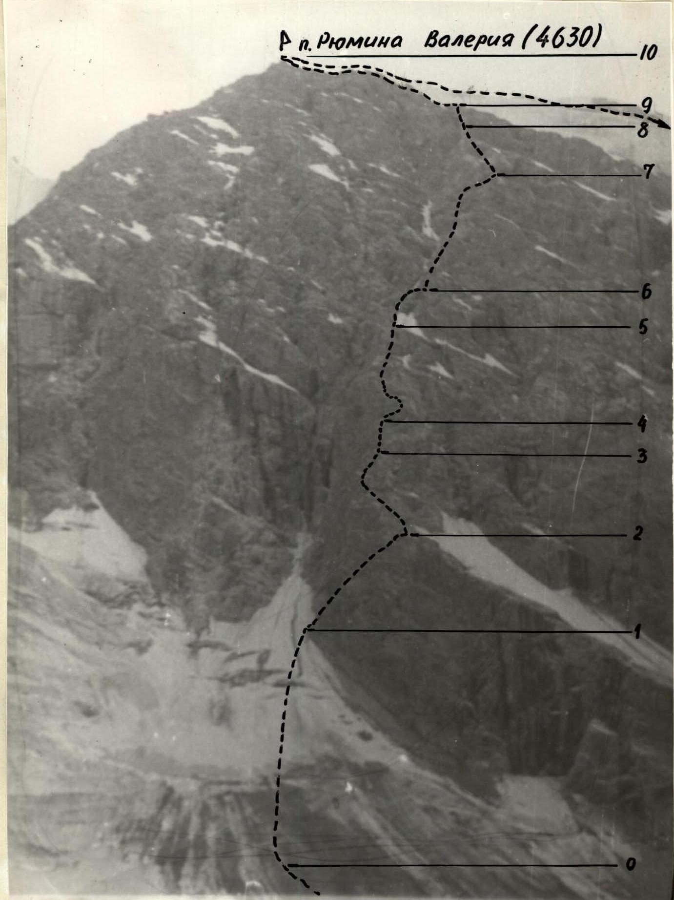 Photo of Valery Ryumin Peak with the 5B route (tentative) marked.
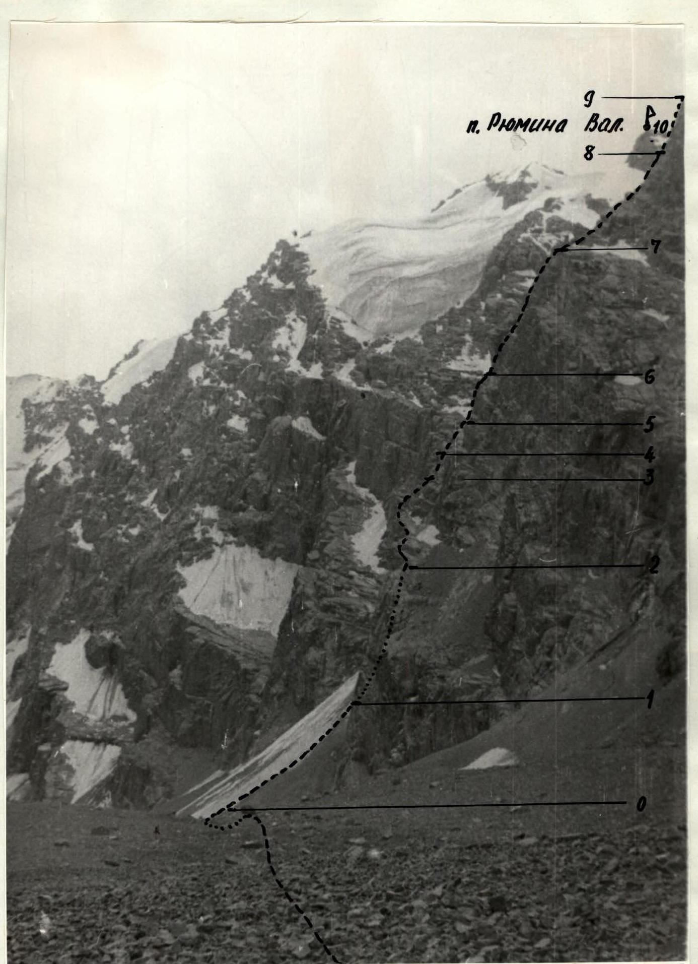 Photo of Valery Ryumin Peak with the route marked.
| Date | Designation | Average steepness in degrees | Length | Terrain characteristics | Difficulty | Condition | Weather conditions | Rock | Ice | Bolt | Rock (m) | Ice (m) | Bolt (m) | Time of departure and stop for bivouac, climbing hours, overnight conditions |
|---|---|---|---|---|---|---|---|---|---|---|---|---|---|---|
| August 7, 1980 | R0–R1 | 45° | 200 m | snow-ice | 3 | ice | good | - | 3 | - | - | 200 | - | 2.0 hours |
| - | R1–R2 | 50° | 60 m | rocky | 4 | rock outcrops | - | 7 | - | - | 60 | - | - | 1.0 hour |
| - | R2–R3 | 60° | 120 m | rocky | 5 | rock slabs | - | 12 | - | - | 120 | - | - | 1.5 hours |
| - | R3–R4 | 90° | 20 m | rocky | 6 | rock outcrops | - | 8 | - | - | 20 | - | - | 1.0 hour |
| - | R4–R5 | 75° | 80 m | rocky | 5–6 | wet rocks | - | 8 | - | - | 80 | - | - | 1.5 hours |
| - | R5–R6 | 70° | 80 m | rocky | 4 | wet rock outcrops | - | 7 | - | - | 80 | - | - | 1.0 hour |
| - | R6–R7 | 70° | 120 m | rocky | 5 | rock outcrops | - | 10 | - | - | 120 | - | - | 2.0 hours |
| August 8, 1980 | R7–R8 | 80° | 180 m | rocky-icy | 5–6 | wet rocks, ice | poor | 15 | - | - | 180 | - | - | bivouac, 3.0 hours |
| - | R8–R9 | 50–60° | 80 m | icy | 5 | ice | - | 5 | 2 | - | 30 | 50 | - | 1.0 hour |
| - | R9–R10 | 60–30° | 250 m | rocky-snowy | 4 | wet rocks, ice, snow | - | 7 | - | - | 250 | - | - | 2.0 hours |
Brief explanation of the table.
R0–R1. Section from the glacier to the rocky outcrop. Overcoming the section and bergschrund with crampons. R1–R2. Exit to the ridge via a rocky spur to the right. R2–R3. Section of rocks to a rounded wall with a dark cave. Chock pitons. R3–R4. Section of the wall. Climbing straight into the face. Very difficult climbing. Chock pitons. R4–R5. Section from the ledge to the snow patch via rock outcrops covered with ice crust. R5–R6. Bypass to the left of a gendarme with a double cornice. R6–R7. Smoothed rocks. Climbing in crampons. R7–R8. Exit to a ledge via a crack from left to right. From the ledge, left into the gap between two slabs. R8–R9. Movement from right to left, bypassing a negative wall via rocks covered with ice. R9–R10. Exit to a rocky snow-covered ridge and along it to the snow-ice dome and to the summit of Valery Ryumin (4630 m).