
Central Council of the Spartak Sports Society
Krasnoyarsk Regional Council of the Spartak Sports Society
Karaganda South — 4850 m
Left part of the East Face
First Ascent
Approximately Category 5B difficulty.
Team Captain: Rodikov A.P., Candidate Master of Sports. Team Coach: Semenyuk V.D., Master of Sports of the USSR.
Krasnoyarsk, 1981
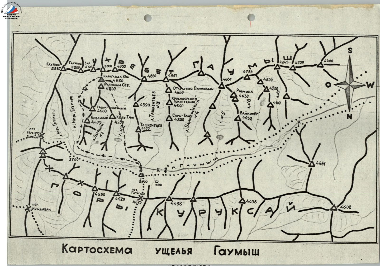
Map of the Gaumysh Valley
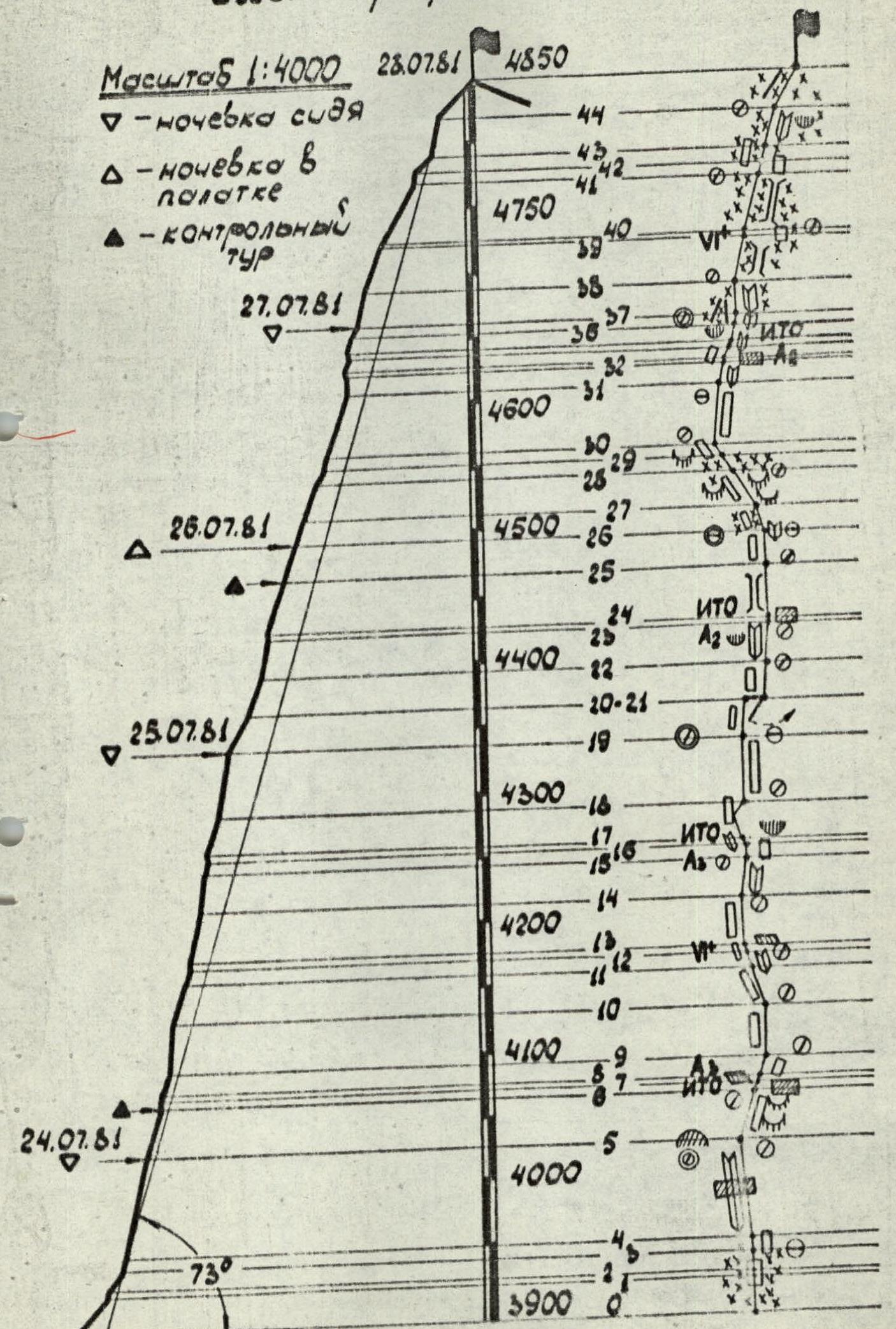
Route length — 1049 m, average steepness — 73°, height difference — 960 m.
1. Brief Geographical Overview of the Area
The object of the ascent — peak 4850 m (Karaganda South) is located in the Northern spur of the Alai ridge, south of the city of Khaydarkan, in the cirque of the Nizhny Gaumysh glacier.
The approach to the cirque is quite straightforward: from the end of the road in the Alaudin river valley (20 km from Khaydarkan) along a trail over the dry, livestock passage Gaumysh pass (4075 m) — 5–6 hours to the base camp, which is best set up on the right bank of the Gaumysh river near a Kyrgyz summer settlement where shepherds live permanently.
From the base camp to the start of the route — 2–3 hours:
- Cross the bridge to the left bank of the river.
- Then follow the trail to the left (orographically) moraine of the Nizhny Gaumysh glacier.
- A good trail on the moraine leads to the upper plateau of the glacier.
On peak 4850 m, one route of Category 5B difficulty has been laid on the right buttress of the East Face (M. Khitrov's route, 1977).
In 1980, a group led by M. Samoilin completed a variant of the route (through the center of the right bastion), also rated Category 5B.
2. Team Preparation for the Ascent
While working as an instructor at the "Dugoba" alpine camp in 1978, team coach Semenyuk V.D., Bychkov V.M., and team captain Rodikov A.P. traveled to the Gaumysh valley to ascend peak Gaumysh Western via the Category 6B route — the Gorenchuk route. They took photographs and examined the East Face of peak 4850 m.
On July 7, 1978, a reconnaissance trip was made to the area of the Nizhny Gaumysh glacier to visually familiarize themselves with the condition of future ascents. The state of the North Face of peak 5200 m (both Efimov's and Gorenchuk's routes) ruled out the possibility of attempting it in the near future. The long-term forecast for July did not offer hope for safe passage of these routes (due to snow avalanches, rockfall, and ice falling directly on the routes due to heavy snowfalls). The subsequent development of events confirmed the correctness of the team's decision. Therefore, the team focused on the East Face of peak 4850 m.
Training ascents for team members were planned and carried out to thoroughly study the path of the future ascent and descent.
July 8:
- Rodikov A.P. and Burlakov P.V. as part of a group ascended peak 4850 m via the North-East buttress, Category 3B difficulty, and thoroughly familiarized themselves with the descent from the summit.
- Khaskin V.Ya. and Figurovsky N.A. made an ascent along the North ridge to peak Bivachny and examined the profile of the upper bastion of the ascent object.
From July 10 to 14, team members completed a classified route of Category 5B difficulty on the right buttress of the East Face, where they experienced the features of the wall's micro- and macro-relief, identified areas most prone to rockfall on the left part of the wall depending on the time of day and weather conditions.
3. Tactical Plan for the Ascent
Based on reconnaissance data and observations of the wall, the team planned to complete the route in 5–6 days:
- Day 1 — traverse the wall to the "pink" slab;
- Day 2 — reach under the "funnel" below the "reddish" overhang;
- Day 3 — reach the "funnel";
- Day 4 — reach the "reddish" bastion;
- Day 5 — reach the summit and descend;
- Day 6 — reserve day.
Given that the ascent would require significant physical and mental effort, serious attention was paid to evenly distributing the workload among team members, achieved by correctly allocating responsibilities and regularly changing the lead climber.
The overall group movement tactic was as follows:
- A pair constantly works at the front.
- The second rope ensures uninterrupted, normal supply of equipment to the front.
Radio communication with observers and the base camp was conducted regularly during scheduled radio hours using "Karat-M" radios. Altitude readings were controlled using an altimeter.
4. Brief Description of the Route
On July 23, the team, along with the observation group — Ledentsov A.A., Candidate Master of Sports; Kormukhin N.P., 1st sports category; Pyan kov V.E., 1st sports category; Smetanin N.A., 1st sports category; and senior coach Semenyuk V.D., Master of Sports of the USSR — left the base camp for an overnight stay under the route.
On July 24, at 6:30, they started from the overnight stay under the wall (30 minutes). The ice slope and bergschrund were traversed quickly (R0–R1). The first pair to work was Rodikov A.P. — Figurovsky N.A. The pace was dictated by the fact that the upper part of the bergschrund was "bombarded" with stones with the first sun rays.
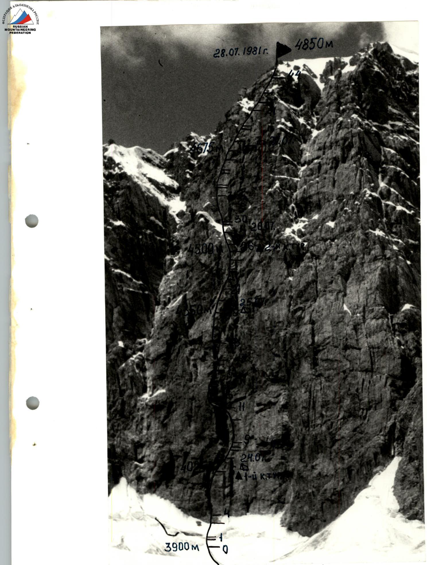
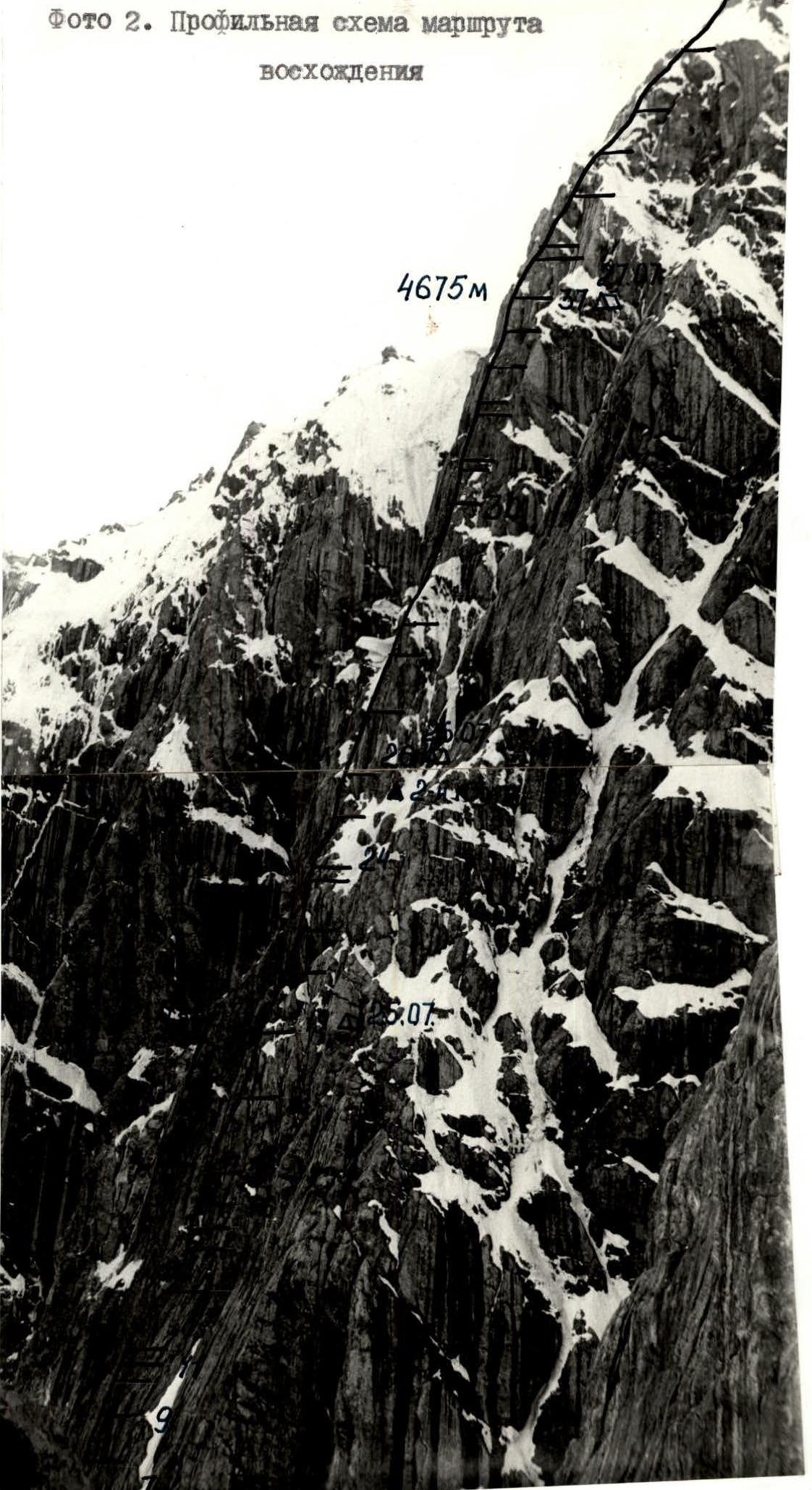
Photo 1. General view of the summit Karaganda South — 4850 m. Photo 2. Profile diagram of the ascent route.
It was very cold and windy, with clear weather. The first two ropes were on the "gray" wall, then on an internal corner with a cornice in the middle (R3–R5). Climbing was complex, with ice on the rocks. The cornice was traversed by climbing. The leading pair was Burlakov P.V. — Rodikov A.P. Long pitons and chock stones were used. Insurance points, both here and throughout most of the route, did not allow more than two people to gather; in many places, it was done sitting in a harness. However, insurance points were chosen for maximum safety, facilitated by the steepness of the wall and abundance of cornices. At the end of the corner, a ledge for an overnight stay was under a cornice. Further, the wall went right upwards (fig. 3) with few holds (R5–R6). Rocks were smoothed out, making climbing very difficult. This wall led under a cornice, which was traversed on the right using artificial aids (R6–R8). The cornice was destroyed and required great caution. The exit was onto a small scree ledge under the "gray" wall. ATTENTION! PASS THE LEDGE VERY QUICKLY! ROCKFALL! Upwards on the "gray" wall (rocks were destroyed, climbing was difficult) to a small ledge (R8–R9). It was a convenient insurance spot, one of the few. From the ledge, straight up. Climbing was very difficult. At the top, there was an overhang. After the overhang, the exit was onto a narrow inclined slab. They managed to hang another rope (photo 4) on wet slabs and an internal corner with a waterfall to under the "pink" slab (R11–R12). That was supposed to be the first overnight stay. However, as the anticipated ledge was not there, for safety reasons (stones and ice were falling), they decided to descend for an overnight stay on the section R5–R6. The overnight stay was safe, sitting. Time: 21:00. Everyone was settled. On this day, Burlakov P.V. worked first. All rock sections were climbed in galoshes.
July 25. Very cold. Clear. Rise at 6:00. Started moving on the route at 8:00. Quickly traversed the hung ropes (1 hour 10 minutes). At 9:20, the pair Figurovsky N.A. — Rodikov A.P. began the ascent on a narrow inclined slab and further on a 5 m wall at 90° (photo 5, R12–R13). Climbing was very difficult. Pitons were hard to place; chock stones were helpful. On the left part of the "pink" slab, 40 m (R13–R14), six pitons were hammered. The exit was under an internal corner. Up the corner, 30 m, to a cornice (R14–R15). From the cornice, on a steep slab to the left, 10 m, under an overhanging internal corner (95°). Climbing was complex; passing the corner could result in a "pendulum" swing. The internal corner was traversed with one artificial aid. Up the wall, 30 m (rocks were monolithic, 70°) to a long monolithic wall, 80° — 50 meters (R18–R19). Here, there were no places for an intermediate anchor due to poor piton placement and few spots for chock stones. It was advisable to traverse the slab completely. Overnight stay spot. Rocks in this area were destroyed, so they managed to clear a small ledge. The overnight stay was safe, under a cornice, very uncomfortable (photo 6). Time: 21:00.
July 26. Rise at 7:30. Cold. Wind. Cloudy. Ahead worked Khaskin V.Ya. — Burlakov P.V. On a wall composed of blocks, they approached under the "reddish" cornice (R19–R20). The belay point was very uncomfortable; only one person could be belayed. To the right, upwards under the cornice on wet slabs, they passed under a waterfall (photo 7). The cold shower was very unpleasant. The first climber's feet froze in wet galoshes. The slab was 30 m, 70°. On the slab, they approached under an internal corner. Up the corner (with an overhang at the top), 30 m (R22–R23). Climbing was complex and unpleasant; rocks were destroyed, pitons held poorly. They approached under the second waterfall.
The group had worked together for a long time, and a tradition had formed to have the same person lead throughout the day on similar terrain. However, as the leader had gotten thoroughly wet under the waterfall and his feet were freezing in wet galoshes, at 14:30, they decided to change the lead climber. By then, it was nearing communication time, and the terrain allowed the group to gather together. Figurovsky N.A. and Rodikov A.P. took the lead. They traversed a cornice (R23–R24). Wet blocks, water streaming down. One artificial aid was used. Further up, on a wet monolithic chimney, 40 m, 70°, they entered the base of a rock "funnel" (R24–R25). The second control point, like the first, was on a hook in a pit. ATTENTION! The "funnel" was subject to rockfall and ice. For safety, they entered the "funnel" on its right side (photo 8) via an internal corner, 30 m, 70°. On the right side of the "funnel," under a cornice, there was a convenient and safe spot for an overnight stay. Two climbers organized a platform while Figurovsky N.A. and Burlakov P.V. continued to process the route. Climbing was very difficult; rocks were covered with ice. One rope was hung. At 19:00, everyone was on the overnight stay. This time, the overnight stay was comfortable, in a tent.
July 27. Woke up at 7:30. Departure at 9:00. Cold. Sky covered with clouds. Light wind. All signs indicated that the weather was about to deteriorate. Ahead worked Burlakov P.V. — Rodikov A.P. They traversed the hung rope. On "sheep's foreheads," 30 m, left upwards (R27–R28). Only thin-bladed pitons and chock stones could be used (large hexes). On a snow-ice slope, 10 m, 55°, they entered a "mushroom" and further under a monolithic slab (R29–R30). On the slab, 75°, 8 m, onto a wall composed of blocks. For insurance, they mainly used chock stones. After 50 m of wall, 70° (R30–R31), an internal corner, 90°, 15 m. Climbing was very difficult. Time: 15:00. Weather deteriorated as expected. Fog. Snowfall. They approached under a small cornice, which was traversed by climbing. After the cornice, a wall, 10 m, 75° (R33–R34), and monolithic rocks quickly covered with continuously falling snow. They approached under a very complex internal corner with an overhang, 95° — 6 m (R34–R35). One artificial aid was used. Due to bad weather and complex terrain, they climbed with maximum tension. Further, the corner eased to 75°. They traversed 15 m. An ice couloir (R36–R37). On crampons, Rodikov A.P. went first. Time: 19:00. As there was no hope for weather improvement, they decided to process the route until the end of daylight and simultaneously prepare a spot for an overnight stay. The pair Figurovsky N.A. — Burlakov P.V. continued processing and hung two ropes: one on an internal corner, 75°, 25 m, and the second on a chimney, 35 m, 75° (R38–R39). Rocks were covered with ice. Movement was slow. At 22:00, everyone was on the overnight stay. The overnight stay was very uncomfortable. Three sat on a small ledge, one on a выступ above. It snowed continuously throughout the night. Very cold. No dry clothes remained.
July 28. Departure without breakfast at 6:00. No weather improvement. Hung ropes were frozen. "Jumar" devices did not grip. They used cam devices that worked on bending. The pair Rodikov A.P. — Figurovsky N.A. traversed a very difficult ice wall, 5 m (ice was frozen), leading into an ice couloir, 50 m, 60° (ice, destroyed rocks). Here, they used ice screws. Straight up, a wall, 80°, 10 m (R41–R42). Rocks were destroyed, covered with ice. Weather remained bad. They traversed an ice slab, 15 m, 45°. Ice was good, dense. Crampons held well. And then, a surprise: instead of a pre-summit ridge — an internal corner with an overhang, 30 m, 75°. Very difficult climbing. Rocks were covered with ice. Everyone was tired after a difficult night, so they climbed with great caution. There were few places to hammer pitons, but there were good outcrops for insurance. Further, on a simple snow ridge, 40 m, 45°, they reached the summit. Insurance was through an ice axe. Everyone was covered in snow. They struggled to find the cairn. Time: 16:00.
The descent on the already known path did not take much time, although in the lower part of the slope, there were many crevasses, requiring increased vigilance. At 18:00, they were on Glacier No. 2. One hour's walk on grassy slopes, and they were at the base camp. Friends, worried by the weather, greeted them.
On the route, they used a full set of pitons and all available chock stones. Loops made of nylon webbing were very useful, as the abundance of cornices made it difficult to pull the rope through carabiners.
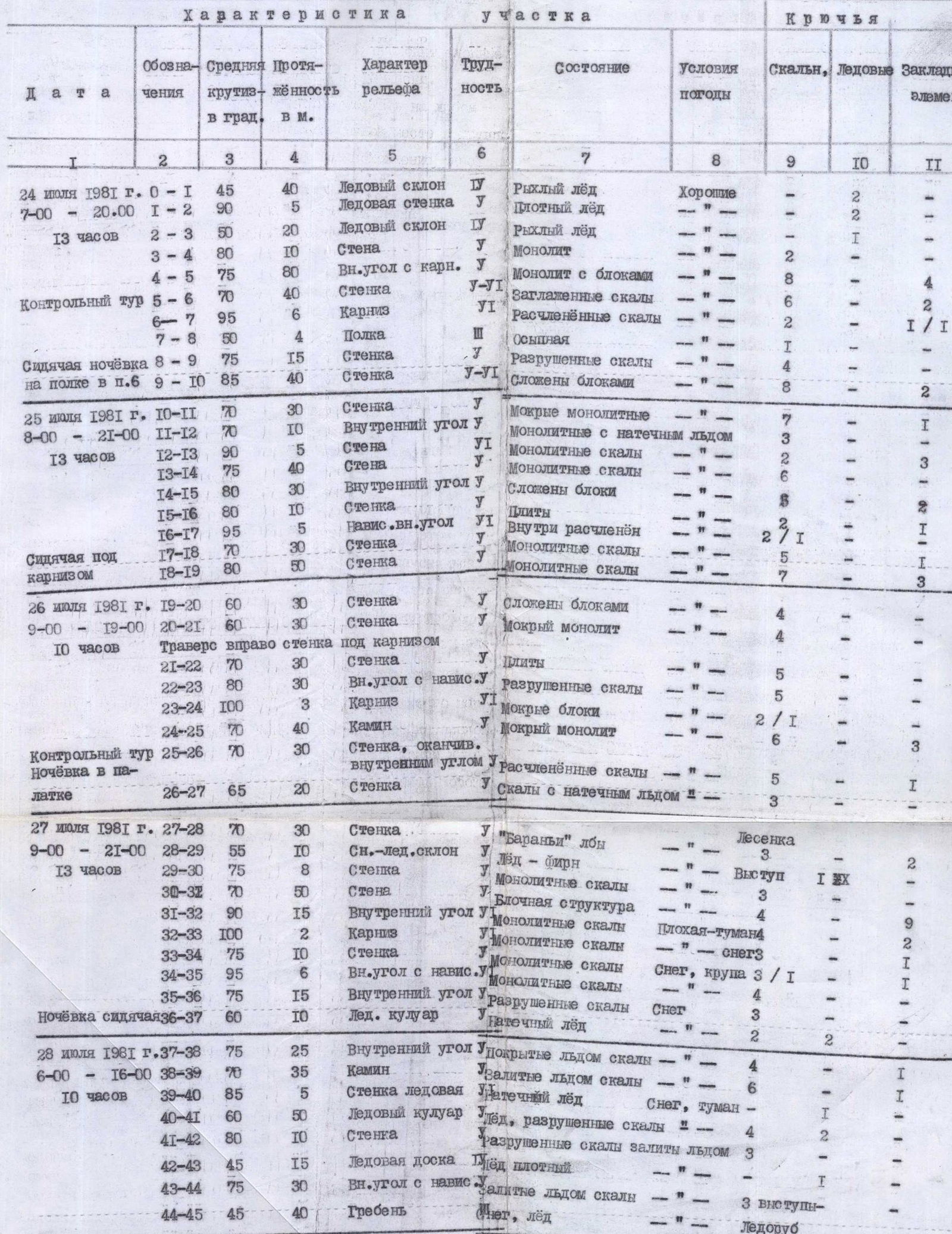
5. Table of Main Characteristics of the Ascent Route
See the table of main characteristics on the spread of page II.
6. Composition of the Observation Group
- Semenyuk Valery Danilovich — Master of Sports of the USSR — team coach.
- Ledentsov Alexander Alekseevich — Candidate Master of Sports.
- Kormukhin Nikolai Potapovich — 1st sports category.
- Pyan kov Vladimir Evstratyevich — 1st sports category.
- Smetanin Nikolai Aleksandrovich — 1st sports category.
7. Protocol of the Ascent Review
July 30, 1981, Gaumysh valley. First ascent on peak 4850 m (Karaganda South) via the left part of the East Face, Category 5B difficulty, approximately — completed by the team from the Krasnoyarsk Regional Council of the Spartak Sports Society.