
- Climbing category — technically challenging.
- Climbing area — Pamir-Alay, Alay Ridge.
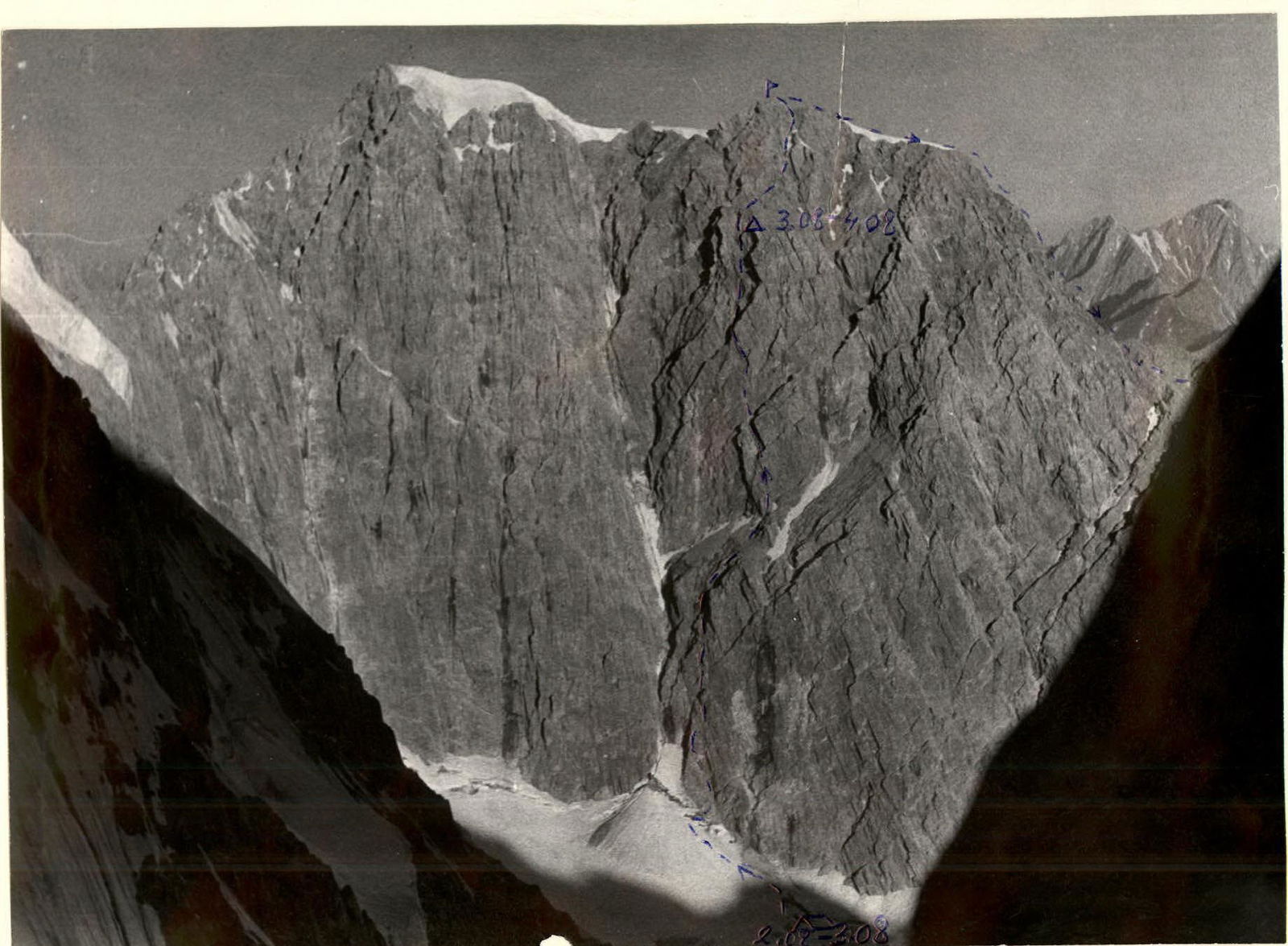
- Climbing route indicating peaks and altitudes: Peak 4700 m. East wall. Via altimeter — 4850 m.
- Climbing description: height difference — 800 m, average steepness — 63°, length of sections with 5B category of difficulty — 450 m.
- Pitons hammered: rock — 74 for belay, 10 for creating anchor points; ice and bolt pitons — none.
- Total travel hours — 21.
- Number of overnight stays and their description: one sitting bivouac on an inclined ledge for four people. Belay on pitons.
- Team name — LGS DSO "SPARTAK".
- Surname, name, patronymic of the leader, participants, and their qualification: Zhukov Sergey Yakovlevich — Candidate for Master of Sports, leader. Silin Boris Mikhailovich — Candidate for Master of Sports. Maerkovich Valeria Vladimirovna — Master of Sports. Golenevskiy Sergey Vladimirovich — Candidate for Master of Sports.
- Team coach — Korkin Igor Vasilievich — Master of Sports.
- Date of departure and return — August 2, 1978 – August 4, 1978

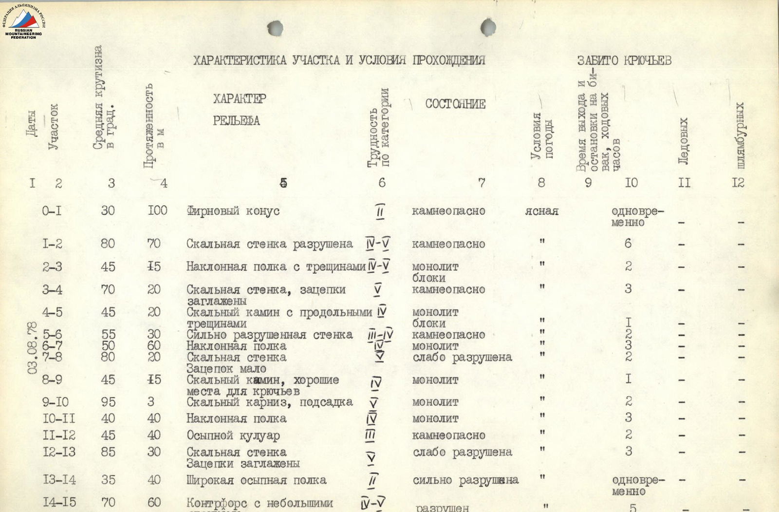
| Dates | Section | Average steepness in degrees | Length, m | Terrain characteristics | Difficulty category | Condition | Weather conditions | Departure and bivouac stop time, travel hours | Ice pitons | Bolt pitons |
|---|---|---|---|---|---|---|---|---|---|---|
| R0–R1 | 30 | 100 | Firn cone | 1 | rockfall hazard | clear | simultaneous | – | – | |
| R1–R2 | 80 | 70 | Rock wall, heavily destroyed | 5 | rockfall hazard | " | 6 | – | – | |
| R2–R3 | 45 | 15 | Inclined ledge with crevices | 5 | monolith | " | 2 | – | – | |
| R3–R4 | 70 | 20 | Rock wall, holds smoothed | 5 | blocks, rockfall hazard | " | 3 | – | – | |
| R4–R5 | 45 | 20 | Rock chimney with longitudinal cracks | 5 | monolith, blocks | " | 1 | – | – | |
| August 3, 1978 | R5–R6 | 55 | 30 | Heavily destroyed wall | 3 | rockfall hazard | " | 2 | – | – |
| R6–R7 | 50 | 60 | Inclined ledge | 5 | monolith | " | 3 | – | – | |
| R7–R8 | 80 | 20 | Rock wall | 5 | slightly destroyed | " | 2 | – | – | |
| R8–R9 | 45 | 15 | Rock chimney, good spots for pitons | 5 | monolith | " | 1 | – | – | |
| R9–R10 | 95 | 3 | Rock cornice, undercut | 5 | monolith | " | 2 | – | – | |
| R10–R11 | 40 | 40 | Inclined ledge | 5 | monolith | " | 3 | – | – | |
| R11–R12 | 45 | 40 | Talus couloir | 5 | rockfall hazard | " | 2 | – | – | |
| R12–R13 | 85 | 30 | Rock wall, holds smoothed | 5 | slightly destroyed | " | 3 | – | – | |
| R13–R14 | 35 | 40 | Wide talus ledge | 2 | heavily destroyed | " | simultaneous | – | – | |
| R14–R15 | 70 | 60 | Buttress with small walls | 5 | destroyed | " | 5 | – | – | |
| R15–R16 | 70 | 40 | Rock chimney. Only on friction | 5 | monolith | clear | 3 | – | – | |
| R16–R17 | 80 | 40 | Rock wall "live rocks" | 5 | slightly destroyed | " | 6 | – | – | |
| R17–R18 | 0 | 0.5 | Ledge for two | – | – | " | – | – | – | |
| R18–R19 | 85 | 40 | Rock wall | 5 | slightly destroyed | " | 5 | – | – | |
| R19–R20 | 45 | 10 | Inner corner | 4 | monolith | " | 1 | – | – | |
| R20–R21 | 80 | 40 | Rock wall | 5 | slightly destroyed | " | 4 | – | – | |
| R21–R22 | 65 | 30 | Few holds, difficult. Traverse of rock overhang. Difficult, ladders | 5 | slightly destroyed, rockfall hazard | " | 3 | – | – | |
| SITTING BIVOUAC WITH BELAY ON PITONS. 56 pitons hammered. Travel hours: 14. | ||||||||||
| August 4, 1978 | R22–R23 | 85 | 80 | Rock wall | 5 | slightly destroyed | clear | 3 | – | – |
| R23–R24 | 75 | 60 | Few holds, rope. Inner corner. Smoothed | 5 | monolith | " | 4 | – | – | |
| R24–R25 | 90 | 4 | Wall with inner corner, ladders, rope | 6 | monolith | " | 3 | – | – | |
| R25–R26 | 70 | 15 | Chimney, turning into inclined ledge under wall | 5 | slightly destroyed, rockfall hazard | " | 2 | – | – | |
| R26–R27 | 0 | 20 | Traverse of wall with exit to talus ledge | 5 | slightly destroyed, rockfall hazard | " | 2 | – | – | |
| R27–R28 | 30 | 40 | Wide talus ledge | 2 | rockfall hazard | " | simultaneous | – | – | |
| R28–R29 | 35 | 40 | Chimney, leading to buttress | 3–4 | rockfall hazard | " | 1 | – | – | |
| R29–R30 | 45 | 40 | Wide talus couloir with snow | 3 | rockfall hazard | " | 2 | – | – | |
| R30–R31 | 25 | 30 | Heavily destroyed rock ridge | 2 | destroyed | " | 1 | – | – | |
| Reached the summit at 13:30. | ||||||||||
| Total pitons hammered — 74. Travel hours — 21. |
Brief explanation of the table of main characteristics of the route to peak 4700 m via the East wall.
From the base camp, located on the left bank of the Nizhnyaya Aylama glacier, the approach is along the left (orographic) moraine towards the couloir separating peaks 4850 m and 4700 m. Along the firn slope to the base of the couloir and, crossing the bergschrund via an ice bridge, approach the base of the East wall of peak 4700 m (section R0–R1). — The first section of the wall — straight up. Steepness 80–85°, piton belay (section R1–R2, photograph 1). — Then along the inclined ledge to the right to the overhanging red wall and along the wall up to a separate standing rock-jendarme. Steepness 45–50°, climbing of medium difficulty, piton belay (section R2–R3, photograph 2). — From the rock — straight up, then along the crevice under the cornice. The cornice is taken head-on (section R9–R10, photograph 3) with an exit to an inclined ledge with few holds. Average steepness 75°, difficult climbing, piton belay. — The inclined ledge turns into a talus area (section R10–R11). On the area — 1st control point. — From the area along the talus couloir to the right to a plug and then along the right wall of the angle up to a not clearly defined buttress (section R12–R13, photograph 4). Steepness 85°, piton belay. — Along the buttress up — exit to a wide talus ledge and along the ledge to the right to a buttress coming from the wall (sections R13–R15, photograph 5). — Along the buttress up — exit under a wide chimney to a ledge (2nd control point). — Along the left side of the chimney up to the wall (section R15–R16, photograph 6). Steepness 70°, piton belay. — Along the wall straight up (to the left in the wall is a cave). Climbing is difficult, piton belay (section R18–R19, photograph 7). Steepness 85–90°. — Further, first along the inner corner, then along the wall in the direction of the red overhang, which is bypassed on the left by a traverse. Climbing is difficult, steepness 85°, pitons, rope (sections R19–R22). — Behind the red outcrop — a sitting bivouac. — After the bivouac along the crevice and inner corner, leaving the overhanging walls to the right. Climbing is difficult, steepness 60–75°, piton belay (section R22–R24, photograph 8). — Further, the inner corner turns into a vertical rock wall. The overhang is taken head-on. Climbing is very difficult, ladders, piton belay. Steepness 90° (section R24–R25, photograph 9). — After the overhang along the wall to the right upwards under a gray rock, which is bypassed by a traverse to the right with an exit to a ridge. Climbing is difficult, pitons, rope (sections R25–R27). — The ridge leads to a wide talus ledge under the summit tower. — Along the talus ledge and rocks of medium difficulty — exit to the summit (sections R27–R31, photograph 10).
Descent from peak 4700 m along the northeast ridge in the direction of peak 4400 m (Spuskovaia) to a saddle along a series of couloirs descending to the Nizhnyaya Aylama glacier. Along talus, sometimes on snowfields — descent to a vertical drop. The drop is overcome by a series of two rappels of 40 m each, leading to a snowfield. Along the snowfield — to the Nizhnyaya Aylama glacier.
The description was compiled by team leader Zhukov S. Ya.
Note: According to our altimeter, the height above sea level at the base of the wall was 4050 m. At the summit — 4850 m.
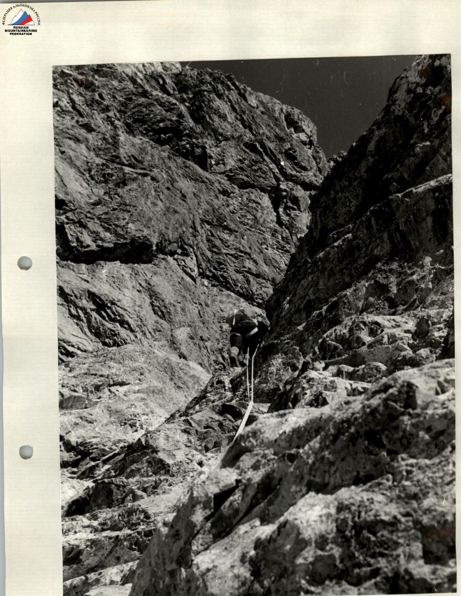
Photograph 5, section R13–R15
Photograph 6, section R15–R16