Ascent Passport
- Ascent class: technical
- Ascent area: Pamir-Alai, Alai Ridge
- Ascent route: Peak 5200 via North face
- Difficulty category: 6
- Route characteristics: height difference: 1200 m length of sections with 5–6 difficulty category: 1245 m average steepness: 74°
- Pitons used:
- rock: 131 (for belay), 12 (for creating intermediate technical objects (ITO))
- ice: 32 (for belay), 2 (for creating ITO)
- bolt: 3 (for belay), 0 (for creating ITO)
- protection elements: 90 (for belay), 15 (for creating ITO)
- Climbing hours: 55 h
- Number of bivouacs and their characteristics: four: one sitting, three hanging
- Surname, name, patronymic of the leader, participants, and their qualification:
- Semenyuk Valery Danilovich, Candidate Master of Sports
- Antipin Sergey Mikhailovich, Candidate Master of Sports
- Bryksin Valery Mikhailovich, Candidate Master of Sports
- Sereda Vladimir Alexandrovich, Candidate Master of Sports
- Svistov Anatoly Mikhailovich, Candidate Master of Sports
- Kurmachev Yuri Fedorovich, Candidate Master of Sports
- Team coach: Yakovlev Vitaly Dmitrievich, Master of Sports of the USSR
- Date of departure and return: departure: July 18, 1978 return: July 23, 1978
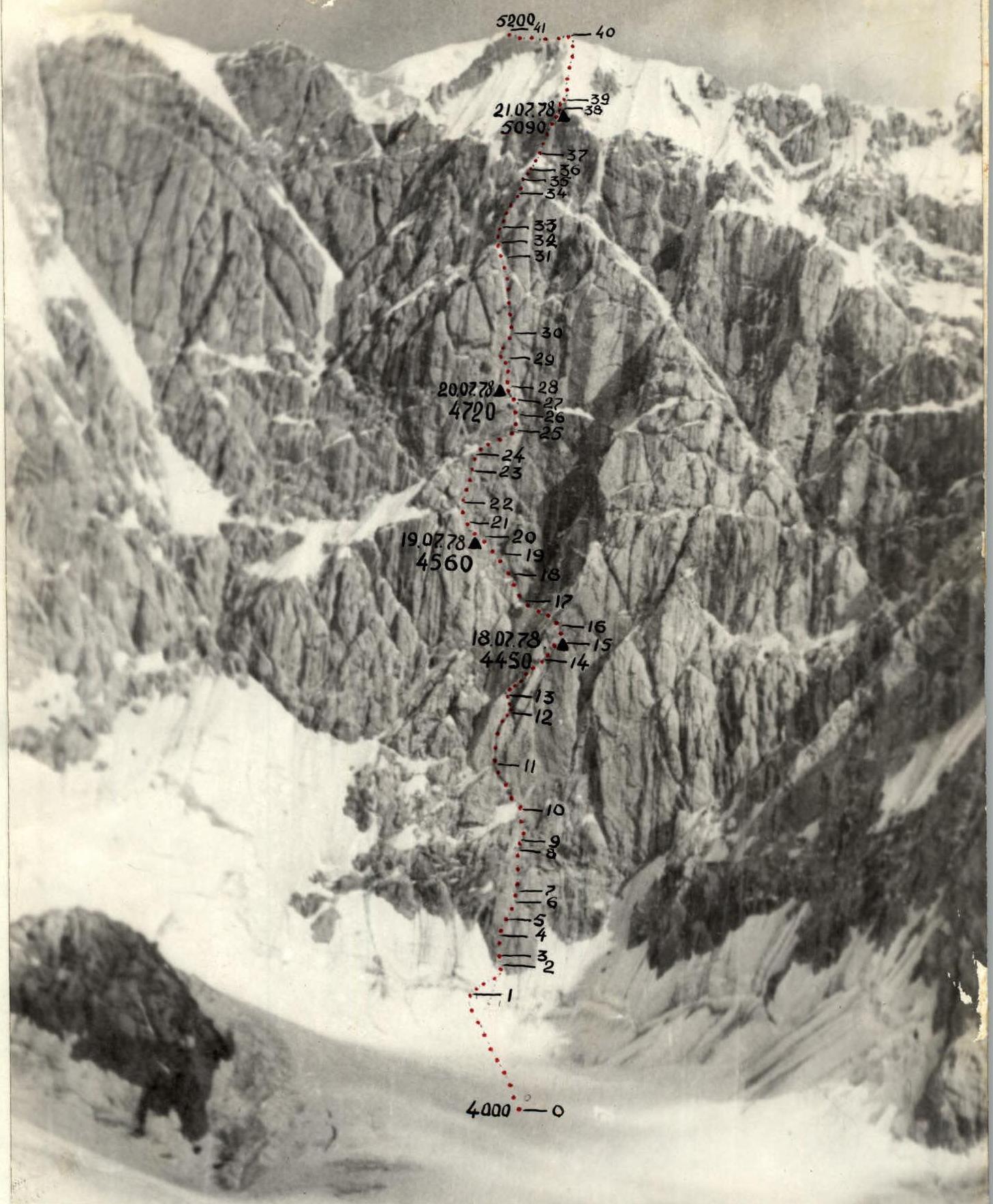
Table of main route characteristics
ascent to Peak 5200 via North face
Route length: 1475 m Height difference: 1200 m Average steepness: 74°
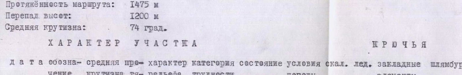
| Date | Designation | Average steepness | Length | Terrain character | Difficulty category | Condition | Weather conditions | Rock pitons | Ice pitons | Protection elements | Bolt pitons |
|---|---|---|---|---|---|---|---|---|---|---|---|
| 17.07 | R0–R1 | 40° | 60 m | snow | 3 | wet | clear | simultaneous movement | - | - | - |
| R1–R2 | 55° | 40 m | ice | 4 | ice | -" | 4 | - | - | - | |
| R2–R3 | 45° | 25 m | rock | 5 | monolith | -" | 3 | - | 1 | - | |
| R3–R4 | 80° | 30 m | wall | 6 | monolith | -" | 3 | - | 2 | - | |
| R4–R5 | 65° | 25 m | slab | 5 | monolith | -" | - | - | 5 | - | |
| R5–R6 | 80° | 20 m | inner corner | 6 | monolith | -" | 4 | - | - | - | |
| R6–R7 | 65° | 20 m | slab | 5 | monolith | -" | 3 | - | 2 | - | |
| R7–R8 | 75° | 35 m | wall | 5 | destruct. | -" | 5 | - | - | - | |
| R8–R9 | 90° | 7 m | wall | 6 | monolith | -" | 0/1 | - | - | - | |
| R9–R10 | 70° | 30 m | chimney | 5 | destruct. | -" | 4 | - | 3 | - | |
| R10–R11 | 60° | 30 m | ice, rocks | 5 | - | -" | 3 | - | - | - |
Route processing from 8:00 to 15:00. Climbing hours 7 h. Bivouac under the route.
| Date | Designation | Average steepness | Length | Terrain character | Difficulty category | Condition | Weather conditions | Rock pitons | Ice pitons | Protection elements | Bolt pitons |
|---|---|---|---|---|---|---|---|---|---|---|---|
| 18.07 | R11–R12 | 90° | 60 m | chimney with ice | 6 | monolith | -" | 9/1 | - | 8/2 | - |
| R12–R13 | 90° | 20 m | wall | 6 | monolith | -" | 3/1 | - | 2/1 | - | |
| R13–R14 | 80° | 70 m | wet wall | 5 | destruct. | -" | 5/1 | - | 8/1 | - | |
| R14–R15 | 85° | 30 m | inner corner (iced) | 5 | destruct. | -" | 3 | - | - | - |
Departure at 9:00. Stop at 19:00. Climbing hours 10 h. Hanging bivouac.
| Date | Designation | Average steepness | Length | Terrain character | Difficulty category | Condition | Weather conditions | Rock pitons | Ice pitons | Protection elements | Bolt pitons |
|---|---|---|---|---|---|---|---|---|---|---|---|
| 19.07 | R15–R16 | 60° | 25 m | ice, rocks | 5 | destruct. | -" | 7 | - | - | 2 |
| R16–R17 | 70° | 80 m | ice | 6 | - | -" | 4/5 | - | - | - | |
| R17–R18 | 85° | 40 m | wall (iced) | 6 | monolith | -" | 4 | - | - | - | |
| R18–R19 | 80° | 20 m | wall | 5 | monolith | -" | 2 | - | 4/2 | - | |
| R19–R20 | 90° | 20 m | chimney (overhang) | 6 | monolith | -" | 6 | - | - | - |
| Date | Designation | Average steepness | Length | Terrain character | Difficulty category | Condition | Weather conditions | Rock pitons | Ice pitons | Protection elements | Bolt pitons |
|---|---|---|---|---|---|---|---|---|---|---|---|
| 20.07 | R20–R21 | 80° | 35 m | chimney | 5 | monolith | -" | 5 | - | - | - |
| R21–R22 | 85° | 20 m | wall | 6 | monolith | -" | 4 | - | - | - | |
| R22–R23 | 70° | 40 m | wall | 5 | monolith | -" | 6 | - | 0/2 | - | |
| R23–R24 | 95° | 10 m | chimney (overhang) | 6 | monolith | -" | 4 | - | - | - | |
| R24–R25 | 60° | 40 m | ice | 5 | - | -" | 2 | - | - | - | |
| R25–R26 | 60° | 20 m | chimney (iced) | 5 | monolith | -" | 0/1 | - | 3 | - | |
| R26–R27 | 90° | 20 m | wall | 6 | monolith | -" | 1 | - | - | - | |
| R27–R28 | 90° | 10 m | inner corner | 6 | monolith | -" | 6 | - | 2 | - | |
| R28–R29 | 80° | 50 m | wall | 5 | monolith | -" | 12 | - | - | - |
Departure at 8:00. Stop at bivouac at 18:00. Climbing hours 10 h. Hanging bivouac.
| Date | Designation | Average steepness | Length | Terrain character | Difficulty category | Condition | Weather conditions | Rock pitons | Ice pitons | Protection elements | Bolt pitons |
|---|---|---|---|---|---|---|---|---|---|---|---|
| 21.07 | R29–R30 | 85° | 35 m | chimney (overhang) | 6 | monolith | -" | 6 | 2 | 15 | 1 |
| R30–R31 | 90° | 110 m | chimney (iced) | 5 | destruct. | -" | 6 | 2 | 13 | - | |
| R31–R32 | 50° | 20 m | ice | 5 | - | -" | 1 | 1 | - | - | |
| R32–R33 | 70° | 20 m | wall | 5 | destruct. | -" | 3 | - | - | - | |
| R33–R34 | 90° | 40 m | inner corner | 6 | monolith | -" | 3/3 | - | 6/2 | - | |
| R34–R35 | 70° | 20 m | wall | 5 | monolith | -" | 6 | - | - | - | |
| R35–R36 | 75° | 20 m | wall | 6 | destruct. | -" | 3 | - | - | - | |
| R36–R37 | 50° | 30 m | ice | 5 | - | -" | 3 | - | - | - | |
| R37–R38 | 70° | 40 m | wall | 5 | destruct. | -" | 6 | - | 5 | - |
Departure at 9:00. Stop at bivouac at 21:00. Climbing hours 12 h. Hanging bivouac.
| Date | Designation | Average steepness | Length | Terrain character | Difficulty category | Condition | Weather conditions | Rock pitons | Ice pitons | Protection elements | Bolt pitons |
|---|---|---|---|---|---|---|---|---|---|---|---|
| 22.07 | R38–R39 | 90° | 10 m | wall | 5 | destruct. | -" | 3 | - | 2/2 | - |
| R39–R40 | 55° | 120 m | ice | 5 | destruct. | -" | 10 | - | - | - | |
| R40–R41 | 30° | 80 m | ridge | 3 | destruct. | -" | simultaneous movement | - | - | - |
Departure at 12:00. Reached the summit of Peak 5200 at 16:00. Climbing hours 4 h.
.
R22–R23. The wall becomes somewhat easier and leads under an overhanging chimney.
R23–R24. 10-meter chimney about 1 m wide with ice inside and rocks protruding from it. Leads to a steep rocky ledge filled with ice.
R24–R25. Along the ice right and up on crampons under the base of an inclined iced chimney.
R25–R26. Up the ice in the chimney under the wall.
R26–R27. Sheer wall, up it to an inclined scree ledge where the 1st control cairn is located.
R27–R28. From the ledge up a vertical inner corner onto a steep wall, which is covered from above by a giant rocky cornice.
R28–R29. Up the wall straight up into the beginning of a sheer chimney cutting through the wall.
R29–R30. Chimney with an overhang in the upper part and a lack of holds leads to a small ledge where three people can gather.
R30–R31. About 10 m along a smooth wall; then right into an iced chimney, on ice on ladders — transition to its right side along the route and up along iced, water-soaked rocks.
R31–R32. Top of the chimney — an ice groove resting against an overhanging ice cornice. Along the ice right under the wall.
R32–R33. Along the destroyed wall left under the base of a vertical inner corner.
R33–R34. Limiting climbing along sheer inner corner walls, the middle part of which overhangs, using ITO.
R34–R35. From the inner corner left onto a steep monolithic wall with a minimal number of holds and cracks. Up it onto a small ledge.
R35–R36. Destroyed rocky wall, sprinkled with snow. местами — rime ice.
R36–R37. From the wall onto a vaguely defined ice rib, along it to the upper belt of rocks.
R37–R38. Steep, heavily destroyed rocks, rime ice.
R38–R39. Sheer short destroyed wall leading to the base of an ice rib.
R39–R40. Along the right (along the route) part of the rib on ice sprinkled with snow, exit to the summit ridge.
R40–R41. Wide ridge leads to the summit.