
Ascent Passport
- Ascent class: high-altitude and technical
- Ascent area: Pamir-Alay mountain range
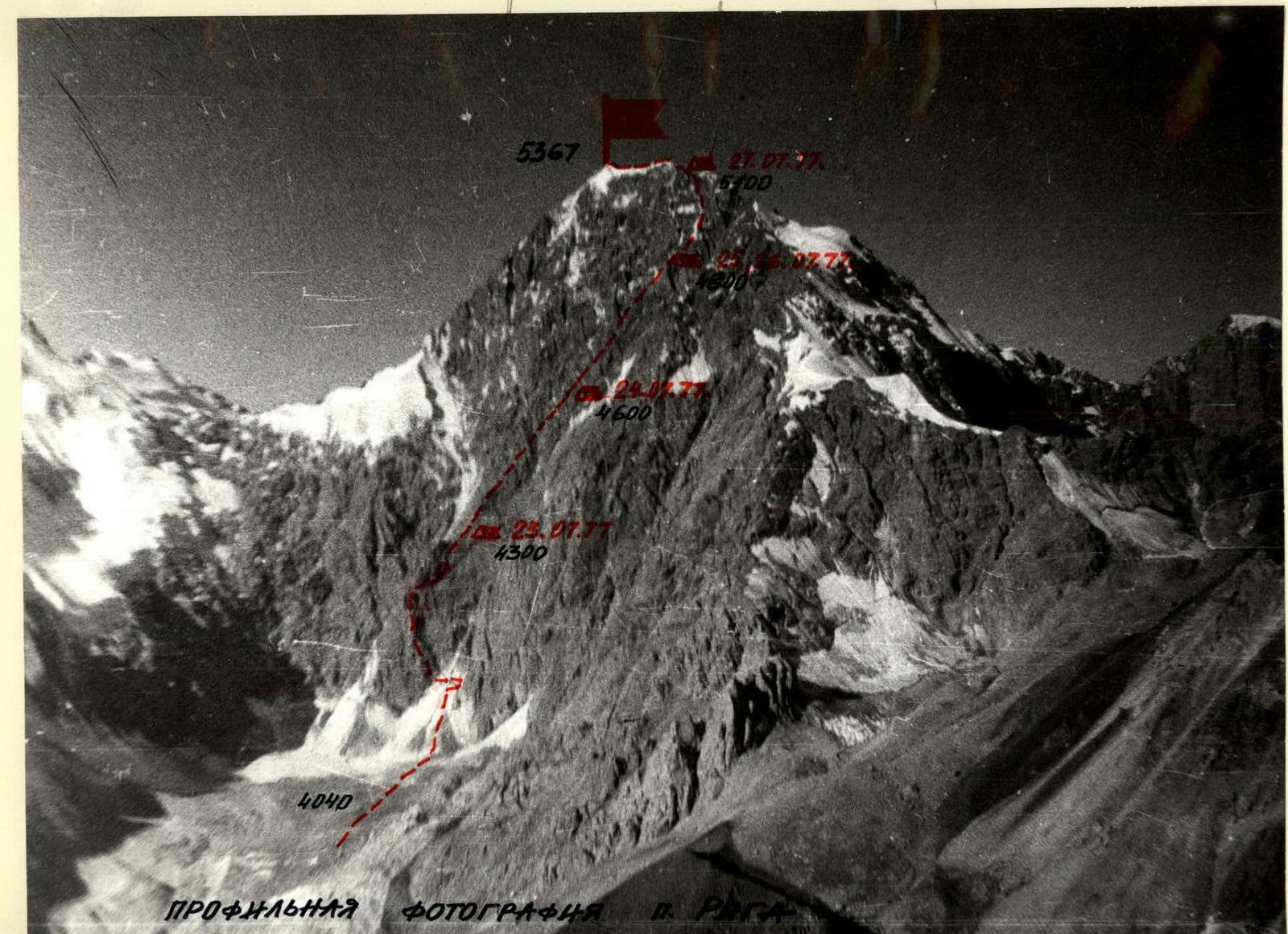
- Peak, its height, and ascent route: p. Riga 5367 m via the central buttress of the E wall
- Proposed difficulty category: 5B category of difficulty
- Route characteristics: height difference 1300 m, average slope 62° Length of sections: R1 – 60 m R2 – 30 m R3 – 460 m R4 – 1430 m R5 – 1465 m R6 – 60 m
- Number of pitons: for belaying Rock: 145 Ice: 17 Bolts: none For creating Intermediate Anchorage (ITO): 10
- Number of climbing hours: 45.5
- Number of bivouacs and their characteristics: 5 bivouacs
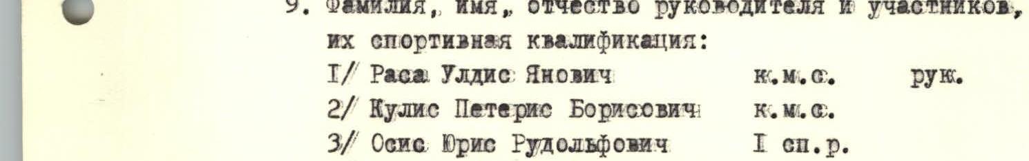
- Surname, name, patronymic of the team leader and participants, their sports qualification:
- Rasa Uldis Yanovich — Candidate Master of Sports, team leader
- Kulis Pетерis Borisovich — Candidate Master of Sports
- Osis Juris Rudolfovich — 1st sports category
- Kozans Marks Pетерisovich — 1st sports category
- Team coach: Rasa Uldis Yanovich
- Date of departure on the route and return: from 22.07.1977 to 29.07.1977.


Geographical description of the area and climbing conditions in the Koksu area
The Pamir-Alay mountain range includes several mountain ranges:
- Turkestan
- Zeravshan
- Gissar
- Alay (in the southeast)
The Alay mountain range stretches from west to east with heights up to 5539 m (p. Tamdykul) and a length of about 400 km. It is mainly composed of thick strata of sandy-clay rocks and crystalline schists. The northern slopes are gentle, while the southern slopes steeply drop off to the Alay Valley.
The Alay Valley is situated between the Alay and Trans-Alay mountain ranges. It stretches from west to east for 150 km, with a width of 8 to 25 km. The height ranges from 2240 m in the west to 3536 m in the east (Tomurun pass).
From p. Osh, through the Taldyk pass, passing Sary-Tash, we enter the Alay Valley. We travel along the highway in a westerly direction to Darut-Kurgan. From Darut-Kurgan, it's another 30 km to the village of Kojdeba, where the Koksu River merges with the Kyzylsu.
Along the right bank of the Koksu River, first by car and then by water transport or helicopter, we ascend to the confluence of the Kenissykty River with the Koksu, where there is a helicopter landing pad. The ascent from the end of the motor road takes 7–8 climbing hours, covering a distance of 15 km.
On the clearing (3200 m), we set up a base camp — a convenient location for departures to the surrounding area, including the cirques of the Kenissykty, Abramov, and Alaudin glaciers. The highest peaks in the area are:
- p. 5367 m (p. Riga)
- p. 5205 m (Dostug)
- p. Akhaiderbek (5126 m)
- p. Tekelik
The area is still largely unexplored and undeveloped from an alpinistic perspective. There are numerous unclimbed peaks with possible routes of various categories.
From the clearing, moving upstream along the left bank of the Koksu River, after 4 climbing hours, we reach the upper reaches of the Abramov Glacier. Here is a well-equipped base of the MGD glaciologists, established back in the early 1960s (3800 m), with a helicopter landing pad. It's also possible to set up a base camp here.
From the base camp on the clearing, crossing the Koksu River via a debris fan, we ascend to the cirque of the Alaudin Glacier, where we set up the II camp (4180 m) at the foot of the right lateral moraine of the Alaudin Glacier. The ascent from the base camp on the clearing to the II camp takes 4 hours.
The left side of the Alaudin Glacier cirque is bounded by a series of horseshoe-shaped peaks with steep (up to 800 m) walls facing the glacier. The heights of the peaks in the horseshoe increase towards the ridge of the Alay mountain range from 4634 m to the highest peak in the area — p. 5367 m (p. Riga), with a wall on the east exceeding 1300 m, which is already northwest of the main crest of the Alay mountain range.
To approach p. 5367 m (p. Riga), it's necessary to ascend along the right lateral moraine of the Alaudin Glacier to the Alaudin pass (4310 m) and descend into the valley of the Ekidavan River, thus crossing the Alay mountain range. p. 5367 m (p. Riga) stands out as a larger massif. From the east, the peak is bounded by a wall (1300 m) down to the glacier, which formed in the pocket of the massif. The eastern glacier drops off into the Ekidavan River valley.
To the southwest, the massif of p. 5367 m (p. Riga) descends into the picturesque valley of the Dzhaliayeu River with hot springs. Of interest are possible wall routes in the northwest cirque of the massif, in the valley of the Gaumysh River. The massif is primarily composed of limestone rocks.
Our group planned to ascend to the summit of the massif — p. 5367 m (p. Riga) via the edge of the eastern wall, with a route approximately categorized as 5B. A route categorized as 4A has been completed along the southeastern ridge.
To the northeast of the summit of the massif, the peaks of the Dgoba area are visible. On a clear day, from the peak, a magnificent panorama unfolds to the south:
- Pamir
- seven-thousanders
The valleys are covered with juniper forests, and alpine meadows stretch above. The snow line in the area is at an altitude of 4200 m.
Weather conditions are similar to those in the Dgoba area. Sunny, warm weather quickly gives way to cloudy conditions with strong winds, prolonged snowfalls, thunderstorms, and fog. Visibility sharply decreases, posing particular difficulties when:
- navigating complex routes
- first ascents
- first traverses
Description of the route passage
July 22, 1977
We depart from the Alaudin bivouac at 16:00. We ascend along the lateral moraine to the Alaudin pass (4306 m) in 45 minutes. From the pass, we descend into the Ekidavan valley along a steep snowy slope — onto the glacier. Along the lateral moraine, we reach the tongue of the glacier, which flows out of the eastern cirque of p. Riga. The tongue of the glacier drops off 200 m above the Ekidavan River valley. We ascend along a steep scree slope to the right orographic side of the glacier. Here, on the right bank of the glacier, there are good bivouac conditions (water).
The transition to the bivouac on the p. Riga glacier takes 3 hours. We bivouac here.
July 23, 1977
We depart from the bivouac at 5:30 and ascend to the upper reaches of the eastern cirque glacier of p. Riga.
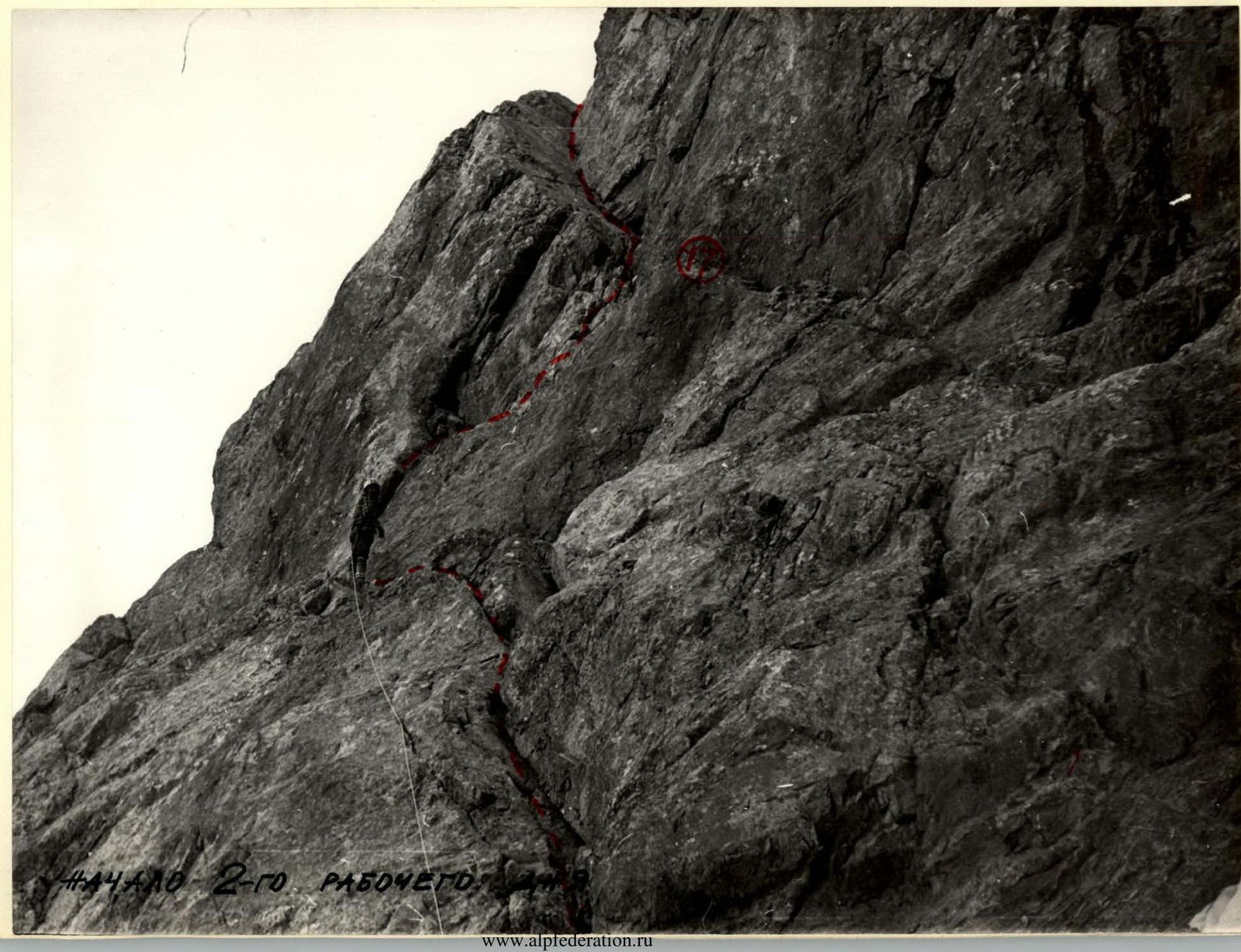
The starting point of the route is marked by the central buttress, bounded on both sides by couloirs. The buttress begins with a pronounced rock wall — a triangle.
The approach to the route takes 1 hour 30 minutes.
R0–R1
We link up in rope teams and start the route at 7:15. Along a steep snowy slope, which becomes steeper at the top, we reach a deep, wide bergschrund. The upper side of the bergschrund drops off with a high negative ice wall. After examining the bergschrund, reaching the rocks, we bypass it from the right.
R1–R2
On the right side of the bergschrund, using rocks for belay, we ascend into the bergschrund and, via snowy bridges, reach a steep snowy slope above the bergschrund. Caution: falling rocks!
R2–R3
Traversing the slope upwards to the left, we reach the first groove, 2 m deep. We overcome it with piton belay. Falling rocks! After 40 m, traversing, we approach the second groove, approximately 1.5 m deep. We pass it with careful belay. Caution, falling rocks! We continue the traverse to the left of the steep snow-ice slope (step-cutting, ice screws) and reach a small snowy "tie-in" leading into a large crevasse.
R3–R4
We overcome the ice "tie-in" (the first climber goes in crampons with step-cutting, piton belay).
R4–R5
From the "tie-in," along a crack to the left upwards (difficult climbing), we approach a narrow chimney. Along the chimney, we ascend into a rocky pocket with loose rocks.
R5–R6
Further, to the right upwards along a crack, we climb onto a narrow, inclined shelf (psychologically challenging).
R6–R7
We traverse the shelf with careful belay, as a rock wall overhangs it (partially traversing the shelf, partially below and on counter-forces), and reach a destroyed wall.
R7–R8
Along the destroyed wall, we ascend to a rocky outcrop.
R8–R9
Ahead is a wall section resembling "ram's foreheads," which we overcome using artificial climbing holds. The wall is characterized by numerous micro-cracks, where only petal-shaped pitons can be placed. Climbing is difficult.
R9–R10
At the top of the wall:
- We traverse to the right to a rocky pocket, where the entire group can gather.
- The traverse is along a broad, smoothed, weakly defined internal angle.
R10–R11
From the pocket, to the right upwards, we exit into a crack, which then turns into an internal angle, along which we reach the edge of the triangle to the left.
R11–R12
Along the edge, straight up, three ropes: along destroyed rocks, with short rock ledges.
R12–R13
Further, we descend to the right, below the edge, and move along a steep, inclined shelf, bypassing a rocky pinnacle, and then ascend back onto the edge along a rocky wall.
R13–R14
We bypass the vertex of the triangle to the right, towards the col between the triangle and the main edge of the eastern wall. The bypass is complex, with an exit onto an open wall (psychologically challenging). Traverse under the overhanging wall along a crack.
R14–R15
Further:
- Straight up along the crack
- With an exit onto the col
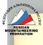
Here is a control point at the start of the scree shelf on the edge of the eastern wall.
R15–R16
Along a narrow scree col, we approach a scree-filled couloir, upwards along it, and on the upper right side, there is a scree shelf. A suitable location for bivouac; we set up bivouac here at 19:30.
Sections of the first day, except for R0–R4, are climbed in Vibram shoes and galoshes. On complex rock sections R4–R6; R14–R15, the lead climbers carried out the rock sections with a lightened rucksack.
July 24, 1977
R16–R17
The rope team Osis–Kozan departs at 7:00 to process the first section, while Rasa and Kulis dismantle the bivouac.
We traverse the ice couloir straight from the bivouac to the left towards a pronounced crack. The first few meters are negative, then we ascend along the crack — one rope length — to an internal angle.
Passage of the section:
- Traverse along the ice couloir from the bivouac to the left
- Movement towards the pronounced crack
- The first few meters are negative
- Then ascent along the crack for one rope length to an internal angle
R17–R18
Along the internal angle, we exit — one rope length — back onto the edge. Climbing is complex.
R18–R19
From the edge, we descend to the left downwards to a "plug." From the "plug," we climb a chimney upwards and exit onto the edge.
R19–R20
Further, along scree-covered rock shelves (30 m) with loose rocks, we reach the first rocky pinnacle on the edge.
R20–R21
The first pinnacle is bypassed by descending to the right, 10 m below the ridge. Along a not very pronounced shelf, we exit to the second pinnacle without ascending to the edge.
R21–R22
Along a rocky chimney to the left, we exit onto the second pinnacle. Descent via climbing: from the pinnacle along the edge onto a large boulder on the snow.
R22–R23
The third pinnacle is bypassed on the right along smoothed slabs (1 rope length). Further, we traverse the ice couloir and, adhering to the wall, along a narrow shelf, we approach a chimney.
R23–R24
30 m of chimney climbing involves difficult climbing, where rucksacks are pulled up. At the top, the chimney becomes very challenging as it narrows and becomes negative.
R24–R25
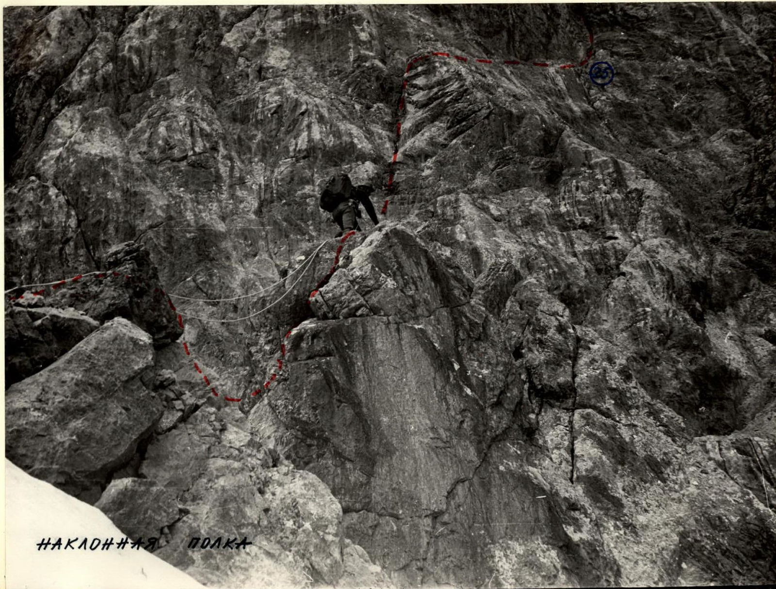
After the chimney, along the wall, we exit onto a narrow, inclined shelf. The shelf:
- Is psychologically challenging due to narrowing in places
- Is passable simultaneously in places
R25–R26
At the end of the shelf, we ascend along the wall upwards via a small crack. Overcoming this wall requires great caution due to small holds.
R26–R27
The wall leads to a narrow shelf. Further:
- Straight up along a destroyed edge
- Along an ice couloir
The edge abuts a wall.
R27–R28
We overcome the wall along a broad internal angle straight up to a snowy shelf.
R28–R29
After passing the snowy shelf, we approach a 20 m monolithic wall. The start of the wall is negative, overcome using a ladder.
R29–R30
We continue along a destroyed ridge below the main edge to a wall with an inclined crack.
R30–R31
Overcoming a 30 m wall with an inclined crack, we exit onto the main edge.
R31–R32
Along the edge to narrow rock "gates," where it's very difficult to pass with a rucksack. After the "gates," we descend 5 m down and then bypass a snow-ice cornice on the left. We ascend back onto the edge with a snowy overhang.
R32–R33
We approach a 30 m complex wall with an inclined crack. Direction towards a rocky outcrop, bypassing it on the right. Climbing is complex, with some sections feeling "off-balance."
R33–R34
Upwards along a destroyed edge for 60 m to a snowy overhang with a cornice. After 1 hour 30 minutes of work, we set up bivouac.
July 25, 1977
It snowed all night. Everything is covered in snow. With the first rays of the sun, we start drying out. The first rope team departs on the route at 9:00. Rasa and Kulis:
- Dismantle the bivouac
- Continue drying the tent
R34–R35
The path lies along a heavily snow-covered edge, 110 m upwards. We climb simultaneously, belaying off outcrops. Some sections of the edge are steep rock ledges, alternating with snow-ice cornices and overhangs.
R35–R36
We approach a 10 m wall on the edge, which we overcome head-on.
R36–R37
We continue along the edge with two 10 m walls. We exit to a pinnacle.
R37–R38
The pinnacle is bypassed on the right along a wall. Very cautious, as everything is covered in snow.
R38–R39
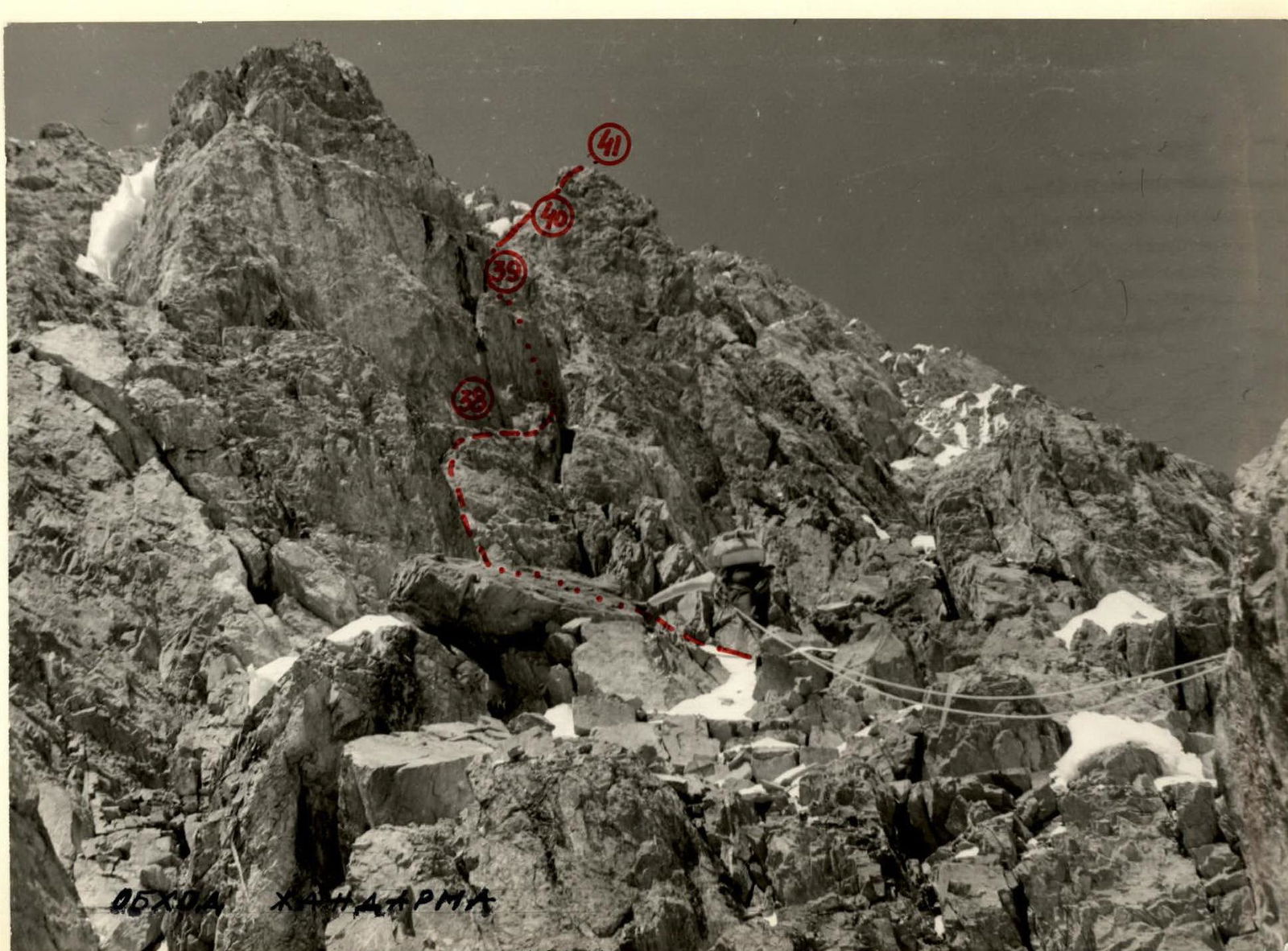
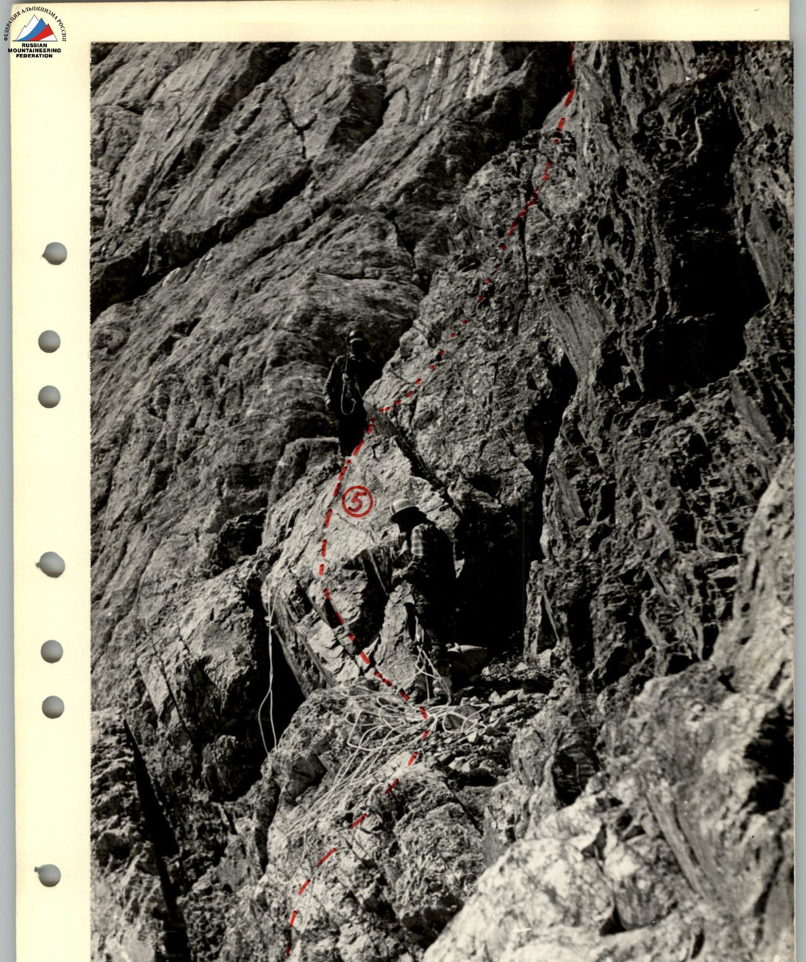
A very challenging section. After crossing a narrow ice couloir (step-cutting, ice screw), we exit onto the north face of the pinnacle. Along the wall straight up (the wall is icy) for 30 m. The wall has very few holds. We exit onto a narrow, inclined shelf, where two people can barely fit. Here, we organize the pulling up of rucksacks, with one person working. Crossing a steep ice couloir (80°) with step-cutting, we exit onto a rocky wall. Along it, straight up for 30 m — onto the ridge of the main edge. One of the key points on the route. We spent 3 hours on this section, and it's the only way to bypass the pinnacle.
R39–R40
Along a sharp snowy edge with large cornices, we approach the next wall. We overcome this section with great caution. The weather deteriorates sharply. We look for a place to set up bivouac.
R40–R41
We approach a very challenging wall, 50 m high, along a sharp snowy edge. We climb to the left along a crack, which we use for belay. Rucksacks are pulled up.
R41–R42
After the wall, we continue along a sharp snowy edge for 60 m. We must move very cautiously due to numerous large cornices and limited visibility. To set up bivouac, we have to cut into an ice cornice and construct a platform using snow and ice bricks.
July 26, 1977
Due to very bad weather (snowfall, blizzard, fog), we take a rest day.
July 27, 1977
The weather is perfect, but everything is heavily snow-covered. Under the first rays of the sun, the snow starts to melt, and the rocks become wet.
R42–R43
We depart onto a wall, 20 m high. The lower part of the wall is icy. The top of the wall is a snowy, dome-shaped overhang, 3 m high.
R43–R44
Again, our path lies along a sharp snow-ice edge with cornices. We move alternately, using running belay. After 70 m, we approach a wall that leads onto the north ridge, along which our path to the summit lies.
R44–R45
This section combines the path to the snow-ice couloir due to similar characteristics. The section is 250 m long, of which 160 m are walls with a slope of 70–90°. The path is very challenging due to small holds and heavy snow cover. In many places, rucksacks had to be pulled up. Steep wall sections, 20–30 m long, alternate with snow-ice ridges and cornices. In many places, cornices overhang on both sides, with a very broken ridge. The average slope of the section is 60°.
R45–R46
Along the snow-ice couloir upwards for 120 m. In places, we have to cut steps. We exit onto the left side of the couloir — to the rocks.
R46–R47
Along the rocks, first 30 m along an internal angle to the left upwards, and then 120 m traversing the wall to the right, exiting onto the right side of the summit ridge. The walls are icy. 10 m down along a rocky-icy slope to an ice col. Here, we carve out a platform for a sitting bivouac. A very strong, piercing wind.
R47–R48
We ascend 180 m along a rocky-icy ridge. The rocks are heavily destroyed. Very cold. We must move very cautiously — loose rocks.
R48–R49
The final section to the summit. The path lies along a snow-ice ridge in a southwest direction. Many cornices. Traversing icy slopes requires step-cutting and belaying off ice screws. We reach the summit.
Descent:
- Along the ascent route to the col.
- Then along the snow-ice couloir 22×60 m (1 × 320 m).
- Descent using a rappel to the Gaumysh glacier.
After lengthy and circuitous navigation around the massif of p. Riga from the NE, we exit into the Ekidavan River valley, where we follow a trail back to the base camp via the Alaudin pass.
We do not recommend the descent route due to the challenging descent along the couloir and the lengthy return journey.

Profile photograph of p. Riga
Wall of the triangle
Brief rest on the wall
Start of the 2nd working section
Inclined shelf
Table of main characteristics of the route 5B category of difficulty on Peak 5367 m (p. Riga)
| Date | Designation | Average slope in degrees | Length in m | Terrain characteristics | Difficulty | Condition | Weather conditions | Rock | Ice | Bolt |
|---|---|---|---|---|---|---|---|---|---|---|
| 23.07.1977 | R0–R1 | 45 | 240 | Snowy slope | 3 | Dense snow | Excellent | – | – | – |
| R1–R2 | 60 | 80 | Bergschrund | 4 | Dense snow, ice, rocks, rockfall | – " – | 1 | – | – | |
| R2–R3 | 66 | 60 | Snow-ice slope with grooves | 4 | Dense snow, ice, rockfall | – " – | – | 3 | – | |
| R3–R4 | 70 | 20 | Icy slope | 5 | Hoarfrost ice | – " – | – | 3 | – | |
| R4–R5 | 90 | 25 | Crack, chimney | 5 | Monolith | – " – | 3 | – | – | |
| R5–R6 | 75 | 40 | Crack | 5 | Monolith | – " – | 5 | – | – | |
| R6–R7 | 40 | 50 | Inclined shelf | 5 | Monolith | – " – | 6, outcrops | – | – | |
| R7–R8 | 65 | 40 | Destroyed wall | 5 | Loose rocks | – " – | 4 | – | – | |
| R8–R9 | 70 | 100 | Wall — type "ram's foreheads" | 5 | Monolith with micro-cracks | – " – | 8 + 4 | – | – | |
| R9–R10 | 50 | 90 | Internal angle | 5 | Monolith | – " – | 4 | – | – | |
| R10–R11 | 50 | 60 | Crack, internal angle | 5 | Monolith | – " – | 6 | – | – | |
| R11–R12 | 45 | 90 | Edge | 4 | Destroyed rocks | – " – | 3, outcrops | – | – | |
| R12–R13 | 55 | 80 | Steep, inclined shelf; wall | 5 | Monolith | – " – | 8 | – | – | |
| R13–R14 | 80 | 50 | Wall | 5 | Monolith | – " – | 4 | – | – | |
| R14–R15 | 80 | 70 | Wall | 5 | Monolith | – " – | 5 | – | – | |
| R15–R16 | 30 | 60 | Scree-filled couloir | 1 | Scree | – " – | – | – | – |
1st day — departure from bivouac at 6:00, arrival at section R0–R1 at 7:15, stop for bivouac at 19:30. Total climbing time — 11 hours 30 minutes. Bivouac conditions good, in a tent on scree.
| Date | Designation | Average slope in degrees | Length in m | Terrain characteristics | Difficulty | Condition | Weather conditions | Rock | Ice | Bolt |
|---|---|---|---|---|---|---|---|---|---|---|
| 24.07.1977 | R16–R17 | 50 | 40 | Crack | 4 | Monolith | Good | 3, outcrops | – | – |
| R17–R18 | 60 | 30 | Internal angle | 5 | Monolith | – " – | 5, outcrops | – | – | |
| R18–R19 | 70 | 30 | Inclined chimney | 5 | Monolith | – " – | 4 | – | – | |
| R19–R20 | 45 | 30 | Rocky shelves with loose rocks | 2 | Rockfall hazard | – " – | outcrops | – | – | |
| R20–R21 | 50 | 60 | Not very pronounced shelf | 4 | Individual rock blocks | – " – | 1, outcrops | – | – | |
| R21–R22 | 70 | 20 | Chimney | 4 | Monolith | – " – | outcrops | – | – | |
| R22–R23 | 60 | 60 | Smoothed slabs | 5 | Monolith | – " – | 3, outcrops | – | – | |
| R23–R24 | 70–95 | 30 | Chimney | 5 | Monolith with loose rocks | – " – | 2, outcrops | – | – | |
| R24–R25 | 45 | 200 | Inclined shelf | 4 | Destroyed shelf, rocks | Clouds, fog | 6 | – | – | |
| R25–R26 | 80 | 40 | Wall with a crack | 5 | Monolith | Fog | 4 | – | – | |
| R26–R27 | 70 | 30 | Destroyed edge | 4 | Loose rocks | – " – | 2, outcrops | – | – | |
| R27–R28 | 70 | 30 | Internal angle | 4 | Monolith | – " – | 2, outcrops | – | – | |
| R28–R29 | 90 | 20 | Wall | 5 | Monolith | – " – | 3 + 2, ladder | – | – | |
| R29–R30 | 50 | 50 | Destroyed ridge | 3 | Loose rocks | Snowfall | outcrops | – | – | |
| R30–R31 | 60 | 30 | Inclined crack | 4 | Monolith | – " – | 3 | – | – | |
| R31–R32 | 50 | 40 | Sharp, snowy edge | 4 | Loose rocks | – " – | ice axe, outcrops | – | – | |
| R32–R33 | 85 | 30 | Wall with an inclined crack | 5 | Monolith | – " – | 5 | – | – | |
| R33–R34 | 45 | 60 | Destroyed edge | 3 | Loose rocks | – " – | simultaneously | – | – |
2nd day — departure from bivouac at 7:00, stop for bivouac at 19:00. Total climbing time — 10 hours 30 minutes. Bivouac conditions satisfactory, in a tent on snow, location narrow. Snowfall.
| Date | Designation | Average slope in degrees | Length in m | Terrain characteristics | Difficulty | Condition | Weather conditions | Rock | Ice | Bolt |
|---|---|---|---|---|---|---|---|---|---|---|
| 25.07.1977 | R34–R35 | 45 | 110 | Snow-covered edge | 3 | Snow, loose rocks | Good, sunny | alternately, outcrops, ice axe | – | – |
| R35–R36 | 70 | 10 | Wall | 5 | Monolith | – " – | 2 | – | – | |
| R36–R37 | 60 | 60 | Ridge with inclined slabs | 4 | Snow-covered rocks | – " – | alternately, outcrops | – | – | |
| R37–R38 | 50 | 30 | Bypass of pinnacle | 4 | Loose rocks with snow | – " – | 2 | – | – | |
| R38–R39 | 85 | 60 | Rocks, ice couloir | 6 | Icy rocks, hoarfrost ice | Overcast | 7 |


