Alpinism Department of the All-Union Central Council of Trade Unions Alpinist Camp "Alay"
Report
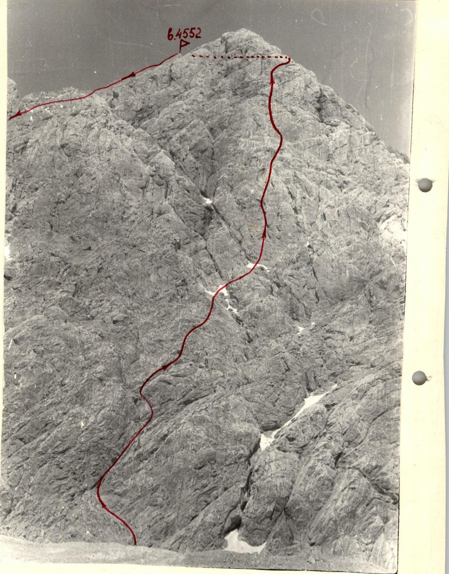
On the first ascent of Peak 4552 (Baykonur) via the west wall, category 4B, tentatively completed by a group of climbers from the "Alay" alpine camp
2nd category coach V. Boldyrev 16/411-8/7. Osh, 1981
Ascent Details
- Type of ascent — technical (rock climbing).
- Region — Pamir-Alay, Gamyush ridge.
- Peak 4552 m (Baykonur), west wall.
- Proposed difficulty category — 4B.
- Route characteristics:
- Elevation gain — 952 m,
- Length of sections with 5th category difficulty — 130 m,
- Average steepness — 53°.
- Number of pitons and other protection used:
- for belaying — 85 pieces,
- for creating belay points and intermediate protection — 2 pieces,
- rock pitons — 60 pieces,
- ice screws — none,
- other protection (e.g., nuts) — 25 pieces.
- Total climbing time — 14 hours.
- Number of bivouacs — none.
- Participants:
- Fischer I.I. — leader, Candidate for Master of Sports,
- Mailov T.E. — 1st category,
- Lavrov O.A. — 1st category,
- Yuryeva N.N. — 1st category,
- Plugin G.P. — Candidate for Master of Sports.
- Team coach — Master of Sports Shkodin V.G.
- Date of departure for the route — July 15, 1981, date of return — July 15, 1981.

Route Profile
Introduction
Peak 4552 m (Baykonur) is located in the 6th glacier of the Gamyush ridge. The main ridge runs from Peak 4630 m "Cosmonaut Ryumin" and descends northwards to the Gamyush River via Peak 4552 m.
A group of climbers from the "Alay" alpine camp, consisting of:
- Fischer I.I. — leader, Candidate for Master of Sports,
- Mailov T.E. — 1st category,
- Lavrov O.A. — 1st category,
- Yuryeva N.N. — 1st category,
- Plugin G.P. — Candidate for Master of Sports,
completed the first ascent of Peak 4552 m via the west wall on July 15, 1981. The route was completed in one day. The route is a rock climb. Based on the experience of the climbers, the route can be classified as category 4B. It is significantly more challenging than similar routes, such as:
- Peak Mekhnat in the Pamir-Alay,
- Peak Diamir in the Fann Mountains.
The route is relatively safe and can be recommended for both training and competitive teams.
Approach to the Route
From the base camp, located below the Gamyush pass, cross the Gamyush River on a log and follow the left bank (in the direction of travel) along a trail to the 6th glacier (1.5 hours), then ascend the moraine to a moraine plateau (1 hour). Cross to the left side of the valley under the west wall of Peak 4552 m.
The route begins 60 m before a couloir that crosses the wall from right to left at an angle of 60–70°.
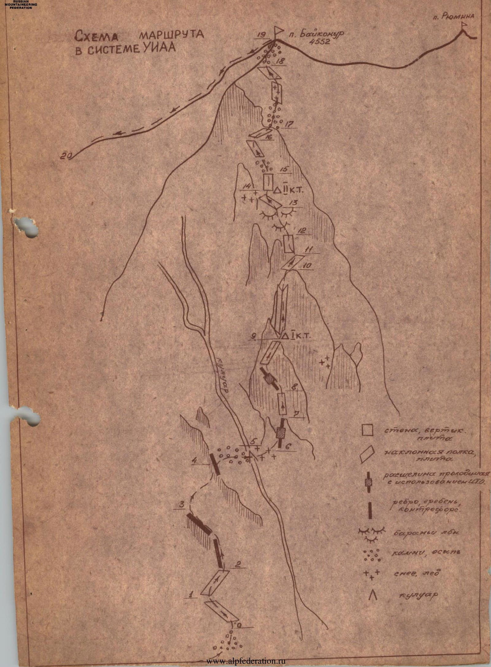
Route Diagram in the UIAA System
Table of Main Route Characteristics

| Date | Section | Average Steepness (°) | Length (m) | Terrain Characteristics | Section Category | Condition | Weather | Rock Pitons | Ice Screws | Other Protection |
|---|---|---|---|---|---|---|---|---|---|---|
| 15.07.1981 | R0–R1 | 50 | 40 | shelf | 2 | broken rock | clear | |||
| R1–R2 | 60 | 60 | shelf | 3 | broken rock | — | 2 | 1 | ||
| R2–R3 | 60 | 50 | ridge | 3 | monolith | — | 2 | 2 | ||
| R3–R4 | 50 | 100 | ridge | 3 | broken rock | — | 2 | 4 | ||
| R4–R5 | 45 | 40 | couloir | 3 | broken rock | — | 1 | 1 | ||
| R5–R6 | 30 | 40 | scree slope | 2 | snow, scree | — | 1 | |||
| R6–R7 | 95 | 20 | crack, slab | 5 | monolith | — | 4 | 1 | ||
| R7–R8 | 80 | 60 | wall | 4 | monolith | — | 4 | 3 | ||
| R8–R9 | 75 | 50 | wall with crack | 5 | monolith | — | 7 | 2 | ||
| R9–R10 | 80 | 40 | internal corner | 5 | monolith | — | 4 | 3 | ||
| R10–R11 | 60 | 25 | inclined shelf | 4 | monolith | — | 2 | 1 | ||
| R11–R12 | 90 | 10 | wall | 5 | monolith | — | 1 | 1 | ||
| R12–R13 | 70 | 160 | glaciated rock | 4 | monolith | 16 | 4 | 1 | ||
| R13–R14 | 50 | 70 | inclined shelf | 3 | monolith | clear | 2 | 1 | ||
| R14–R15 | 90 | 10 | wall | 5 | monolith, water | — | 2+1 | |||
| R15–R16 | 60 | 90 | wall | 4 | monolith | — | 5 | 2 | ||
| R16–R17 | 20 | 30 | inclined shelf | 3 | broken rock | — | 1 | 1 | ||
| R17–R18 | 50 | 150 | slabs | 4 | monolith | — | 5 | 1 | ||
| R18–R19 | 40 | 159 | ridge | 2 | broken rock | — |
Brief Explanations for the Table of Main Route Characteristics for the Ascent of Peak 4552 via the West Wall, Category 4B, First Ascent
R0–R1. Ascend a small scree cone to a diagonal shelf that goes from right to left, 50°, 40 m.
R1–R2. Traverse a diagonal shelf from left to right, 60°, 60 m. Some sections have smooth, inclined slabs. Continue to the main couloir, bypassing a rock ridge on the right and ascending leftwards up the ridge.
R2–R3. Ascend a ridge, bypassing it on the left, 60°, 50 m, and exit onto a scree shelf.
R3–R4. Reach a spur and move along it towards a rock "finger," 50°, 100 m. The main couloir remains to the right.
R4–R5. 20 m before reaching the "finger," turn right and traverse the couloir to its right side, 45°, 40 m.
R5–R6. Ascend rightwards up to the base of a 120-meter rust-colored wall with black streaks. A small snow patch.
R6–R7. Ascend a small snow patch to the start of the crux — a vertical slab detached from the main rock mass, via a crack, 20 m, 95°. Very difficult climbing.
R7–R8. Begin on the rust-colored wall. Ascend a weakly defined "image-like" wall, 80°, 60 m, with a slight deviation leftwards to a rock outcrop (good belay point).
R8–R9. Ascend a steep crack leftwards and upwards (very difficult climbing), then move rightwards onto a small scree shelf, 50 m, 75–80° (first control point).
R9–R10. Move rightwards along the scree shelf and ascend an internal corner (difficult climbing), 75–80°, 40 m. Good shelf.
R10–R11. Move rightwards along the shelf and ascend an inclined smooth slab under a wall, 60°, 25 m.
R11–R12. Crux. Ascend a 90°, 10 m wall (very difficult climbing) and move leftwards upwards.
R12–R13. Ascend directly upwards. A series of glaciated rocks, 70°, 160 m. Some sections involve very difficult climbing (constant piton protection).
R13–R14. Exit onto an inclined shelf from left to right (smooth slabs), 50°, 70 m, and ascend under a wall with a black streak (second control point).
R14–R15. Crux. Ascend a 10-meter smooth wall, 90°. Very difficult climbing, aided by ladders.
R15–R16. Ascend a broken wall, 60°, 90 m upwards towards a light-colored overhanging wall, and exit onto a smooth inclined slab from left to right, 45°, 30 m.
R16–R17. Approach the light-colored wall, bypass it on the right via moderately difficult rock, and exit onto a wide scree shelf that bypasses the wall on the right.
R17–R18. Ascend the shelf to a small, partially ice-filled couloir that leads leftwards to smooth inclined slabs, and ascend these to the pre-summit ridge.
R18–R19. Ascend a spur (broken rock) along the main ridge and reach the summit, 159 m.