
Ascent Passport
Appendix I
- Ascent class - technical
- Ascent area - Pamir-Alay
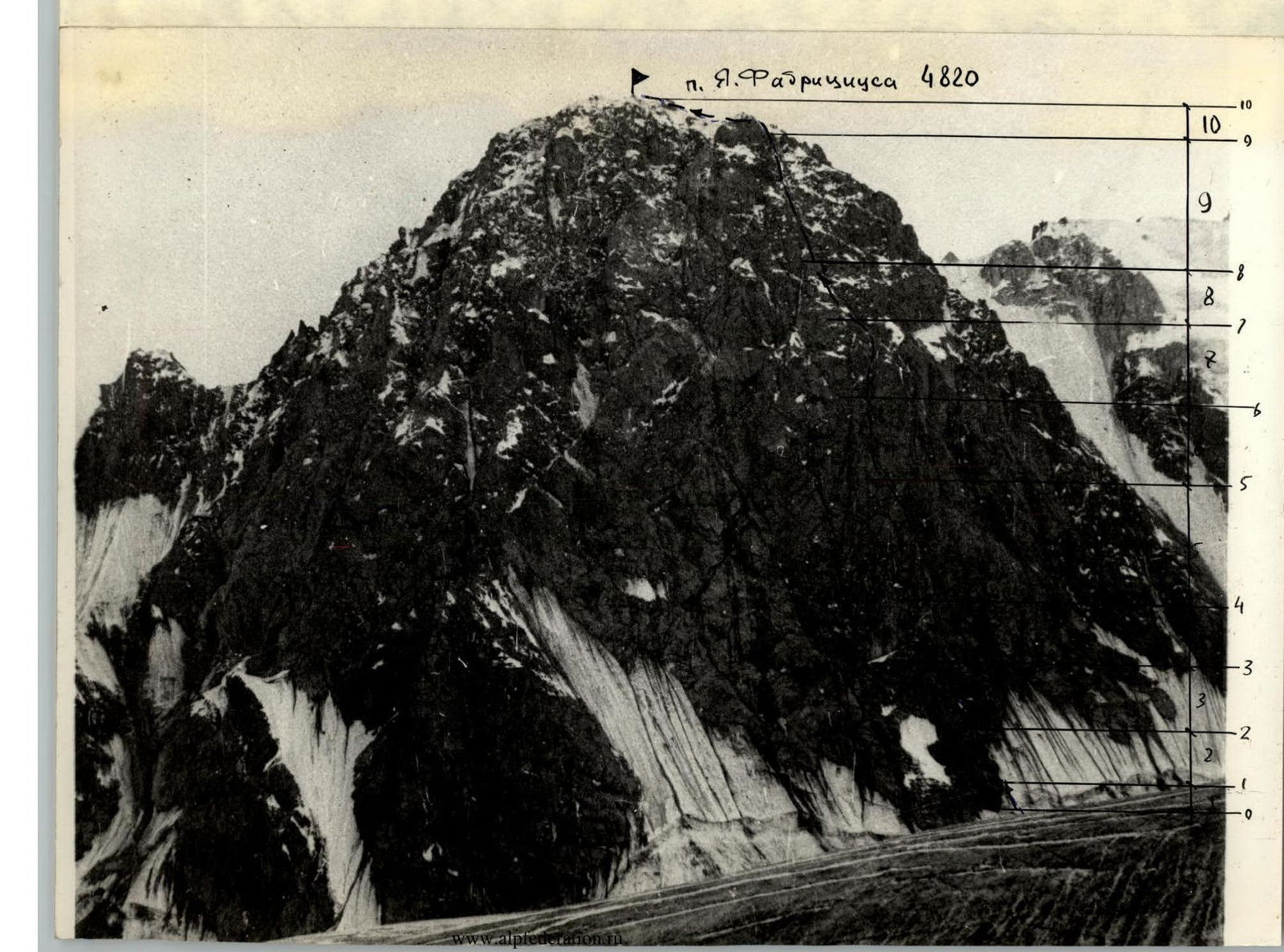
- Peak, its height and ascent route: p. Ya. Fabricius, 4820 m, right side of the north wall
- Estimated difficulty category - 5B
- Route characteristics: height difference - 800 m average steepness - 65° length of sections: R2, R3 - 450 m, R4, R5 - 520 m, R6
- Pitons hammered for belay: rock - 72 ice - bolt -
- Number of travel hours - 12 hours
- Number of overnight stays - none
- Names of team leader and participants:
- Lopatnikov Viktor Vasilyevich - 1st sports category
- Lopatnikov Vladimir Vasilyevich - Candidate for Master of Sports
- Team coach: Agranovsky G.L. - Master of Sports of International Class
- Date of departure and return - August 2, 1979
Appendix 2
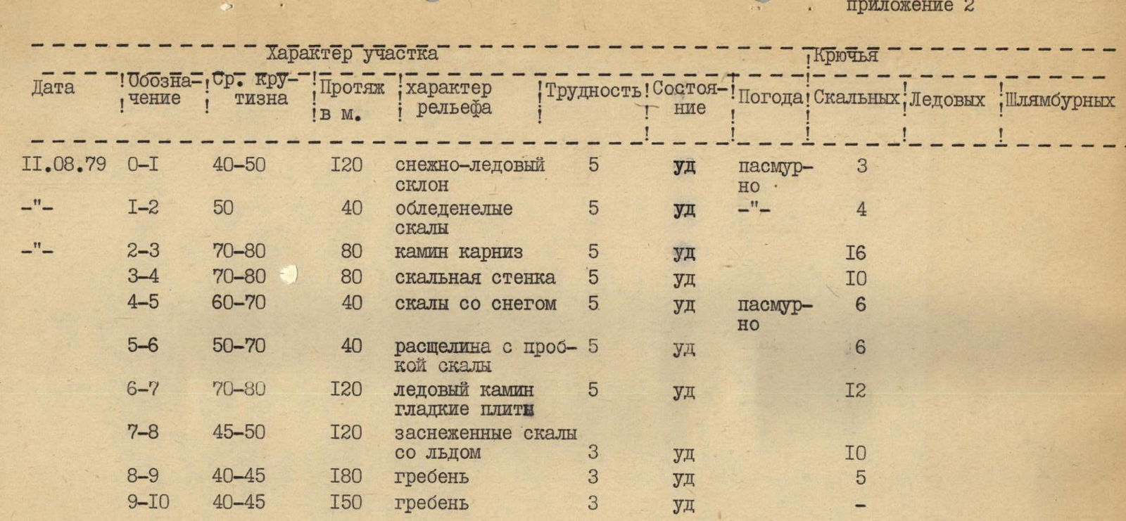
| Date | Designation | Avg. Steepness | Length in m. | Terrain Characteristics | Difficulty | Condition | Weather | Pitons (rock) | Pitons (ice) | Pitons (bolt) |
|---|---|---|---|---|---|---|---|---|---|---|
| August 11, 1979 | R0–R1 | 40–50 | 120 m | snow-ice slope | 5 | satisfactory | overcast | 3 | ||
| August 11, 1979 | R1–R2 | 50 | 40 m | iced rocks | 5 | satisfactory | overcast | 4 | ||
| August 11, 1979 | R2–R3 | 70–80 | 80 m | chimney cornice | 5 | satisfactory | 16 | |||
| August 11, 1979 | R3–R4 | 70–80 | 80 m | rocky wall | 5 | satisfactory | 10 | |||
| August 11, 1979 | R4–R5 | 60–70 | 40 m | rocks with snow | 5 | satisfactory | overcast | 6 | ||
| August 11, 1979 | R5–R6 | 50–70 | 40 m | crack with rock plug | 5 | satisfactory | 6 | |||
| August 11, 1979 | R6–R7 | 70–80 | 120 m | ice chimney smooth slabs | 5 | satisfactory | 12 | |||
| August 11, 1979 | R7–R8 | 45–50 | 120 m | snow-covered rocks with ice | 3 | satisfactory | 10 | |||
| August 11, 1979 | R8–R9 | 40–45 | 180 m | ridge | 3 | satisfactory | 5 | |||
| August 11, 1979 | R9–R10 | 40–45 | 150 m | ridge | 3 | satisfactory | — |
p. Ya. Fabricius 4820
Brief explanation of the route
The route begins with a snow-ice slope and a bergschrund with an exit to a rocky destroyed ledge, further along a heavily destroyed rocky wall with many "live" stones, rocks are iced and snow-covered. Then passage of two chimneys with small footholds. The second chimney is plugged with rock "plugs". Climbing is difficult, at the end of the chimney on a large stone is a belay point. From the belay point along the ledge going up to the right, then under the cornice with a detour to the left, climbing is very difficult. Traverse to the left and through the crack, movement is in "opposition", the crack ends with a plug with a backpack that swings. The section ends with a ledge where an overnight stay is possible. Then along the chimney sealed with ice under the wall, which ends with a slab, climbing is difficult, many live stones. Further along the crack to the right of the smooth slab, the crack ends with a narrow ice groove. Further snow-covered rocks, which alternate with 5-10 meter walls. The rocky pillar is bypassed on the right. The pre-summit ridge is heavily destroyed. Much ice and snow.