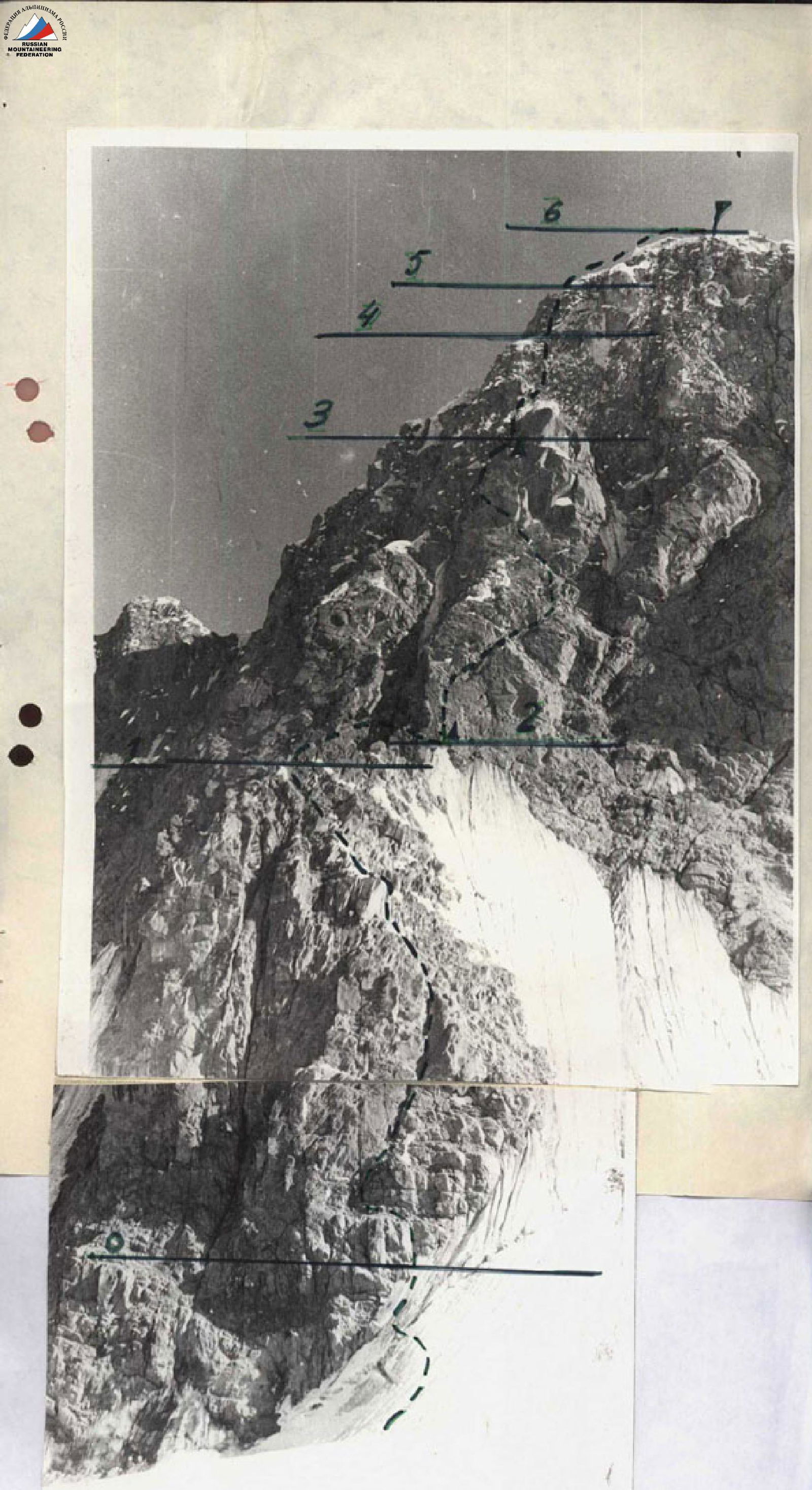
Description of the Ascent Route to Yan Fabricius Peak via the North Face, Category 5B (Second Ascent)
The approach is from Kozhdeba meadow along the trail on the right (in the direction of travel) bank of the Kok-Su River to the Alaudin River tributary, taking 8–10 hours. Along the Alaudin River, without crossing it, ascend via the right (in the direction of travel) moraine (good trails are available). Climb onto the glacier opposite Yan Fabricius Peak and cross the Alaudin Glacier perpendicularly towards the characteristic rhomboid buttress of the North Face.
Ascend to the crest of the rhomboid bastion via the right part of its North Face. Exit to the wall through the bergschrund via a snow bridge. It is recommended to exit onto the rocks in the lower part of the rock wall, as bypassing the bastion on the right and left via ice couloirs is extremely hazardous due to falling rocks and ice fragments. Climbing the north face of the "diamond" is challenging, with piton protection, and in some places, the use of artificial holds. Preliminary processing of the route's beginning with overnight stays on the moraine is recommended.
During the ascent, the following are used:
- small ledges for one person;
- long vertical cracks;
- narrow chimneys.
The rocks are solid, with sufficient cracks for driving in pitons and using chocks.
The direction of movement up the "diamond" wall is upwards, exiting onto the ridge at the upper part of the bastion. Along the bastion's ridge, bypassing giant monolithic blocks, exit onto the crest of the "diamond". The crest has good overnight stay locations, with snow available, and it's possible to level out a tent site.
The crest of the "diamond" is traversed along giant rock blocks, snow drifts, and small, very steep ice couloirs. Movement is sometimes possible simultaneously, with protection on outcrops, and terrain features such as ridge bends are widely used for protection. Technically challenging is the moment of transitioning from the "diamond" crest to the North Face (to the right in the direction of travel, with piton protection: the lead climber ascends a very steep ice couloir in crampons). At the junction of the "diamond" crest with the North Face of Yan Fabricius Peak, there is a control cairn.
From the "diamond" crest, initially straight up the wall, then left towards the couloir. Further movement is recommended along a steep, interrupted rock ledge:
- to the right and up under the vertical wall of the "chip" bastion;
- then to the left and up towards the chimney;
- and through it, via vertical cracks and fissures, to the "chip" shoulder.
On the shoulder, there is a convenient site for the second overnight stay, with a control cairn.
Further, from the saddle connecting the "chip" summit with Yan Fabricius Peak's North Face, move upwards towards the break in the snow cornice, to the left of the characteristic red rock visible from below, from the Alaudin Glacier, and from the "chip" shoulder. Movement is along ledges, rock blocks covered with ice. A feature of this section of the route is the alternating use of rock and ice pitons during the ascent: the use of ice screws is preferable, as the ice is brittle when attempting to drive in old-style ice pitons. In several places, the ascent is facilitated by the use of ladders.
A short, steep snow ridge leads again to a steep counterfort covered with ice. The exit to the summit ridge is via the internal angle between the snow cornices. From the exit to the ridge to the summit, it's 75 meters. There are convenient overnight stay locations.
The descent from the summit is by traversing along the ridge, bypassing Peak 4862 on the left (in the direction of travel), then down via wide, rubble-covered ledges, couloirs, and snowfields. From the start of the descent from the summit to reaching the Abramov Glacier base at the hydrologists' camp, it takes 2–2.5 hours.
At the hydrologists' base, it is recommended to cross to the right (orographically) bank of the Kok-Su River using the hydrological trolley and then move downstream along the good trail to the log jam located below the confluence of the river flowing from the Alaudin Glacier into the Kok-Su River. It's also possible to cross to the right bank of the Kok-Su River via the upper log jam, opposite the giant crevice in the South (left in the direction of travel) wall of Peak 4634.
The Alaudin River is impassable to ford, and if not crossing to the right bank of the Kok-Su River, one will have to ascend to the glacier tongue.
The return to the base camp on Kozhdeba meadow is along the left bank of the Kok-Su River, on a good trail, taking 8–10 hours.

Photo of the general view of Yan Fabricius Peak and a section of the ridge.
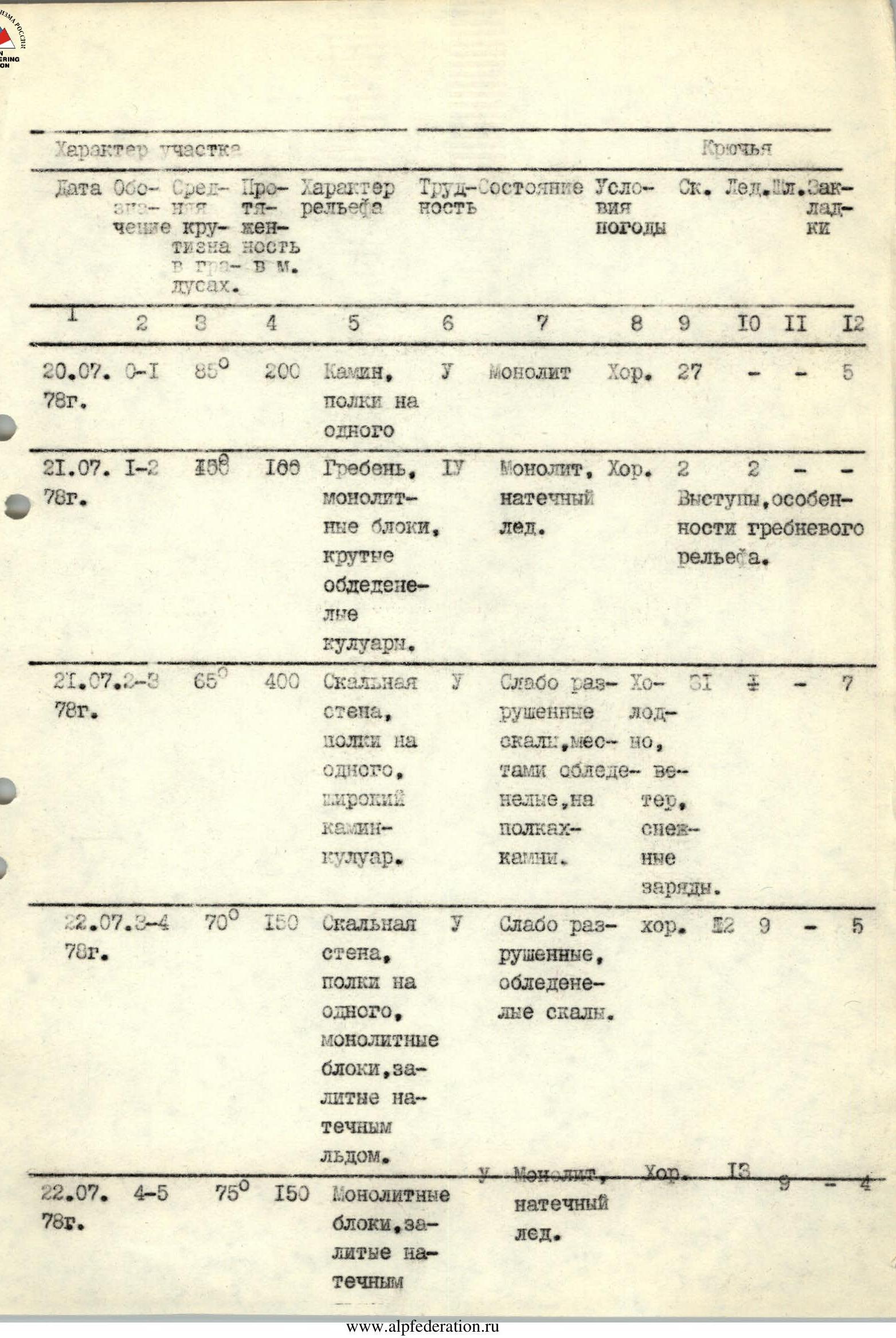
| Date | Section | Steepness, ° | Length, m | Terrain Characteristics | Difficulty Category | Condition | Weather Conditions | Rock Pitons | Ice Pitons | Bolts | Chocks |
|---|---|---|---|---|---|---|---|---|---|---|---|
| July 20, 1978 | R0–R1 | 85° | 200 | Chimney, ledges for one person | 1 | Monolithic | Good | 27 | – | – | 5 |
| July 21, 1978 | R1–R2 | – | 100 | Ridge, monolithic blocks, steep icy couloirs, outcrops, ridge terrain features | 4 | Monolithic, ice accretion | Good | 2 | 2 | – | – |
| July 21, 1978 | R2–R3 | 65° | 400 | Rock wall, ledges for one person, wide chimney-couloir | 1 | Weakly fractured rocks, icy in places, rocks on ledges | Cold, wind, snow showers | 5 | – | – | 7 |
| July 22, 1978 | R3–R4 | 70° | 150 | Rock wall, ledges for one person, monolithic blocks covered with ice | 1 | Weakly fractured, icy rocks | Good | 12 | 9 | – | 5 |
| July 22, 1978 | R4–R5 | 75° | 150 | Monolithic blocks covered with ice | 1 | Monolithic, ice accretion | Good | 13 | 9 | – | 4 |
| July 2, 1978 | R5–R6 | 25° | 150 | Ridge, scree, easy rocks | 4 | Weakly fractured, snowy rocks | Good | – | – | – | – |