Ascent Passport
- Ascent class — rock climbing.
- Ascent area — Alai Range.
- Peak, its height, ascent route — Terekhova Peak, 4830 m, via the southern ridge.
- Expected complexity category — 4B.
- Route characteristics — rock climbing, height difference — 650 m, length of sections with 5th category difficulty — 100 m, average steepness of the route — 60°.
- Pitons hammered in:
| for belaying | for creating artificial footholds | |
|---|---|---|
| rock | 3 | none |
| ice | none | none |
| bolt | none | none |
- Number of travel hours — 8 hours.
- No overnight stay on the route.
- Last names, initials of the leader and participants, and their qualifications.
Leader: 1. Molnar V. I. — 2nd sports category. Participants: 2. Kozlov Yu. E. — Master of Sports. 3. Piskun V. G. — Candidate for Master of Sports. 4. Mikhailov E. I. — 2nd sports category. 5. Safronova T. I. — 2nd sports category.
- Team coach Naumov A. F.
- Date of departure and return — July 12, 1978.
General view photo of the peak
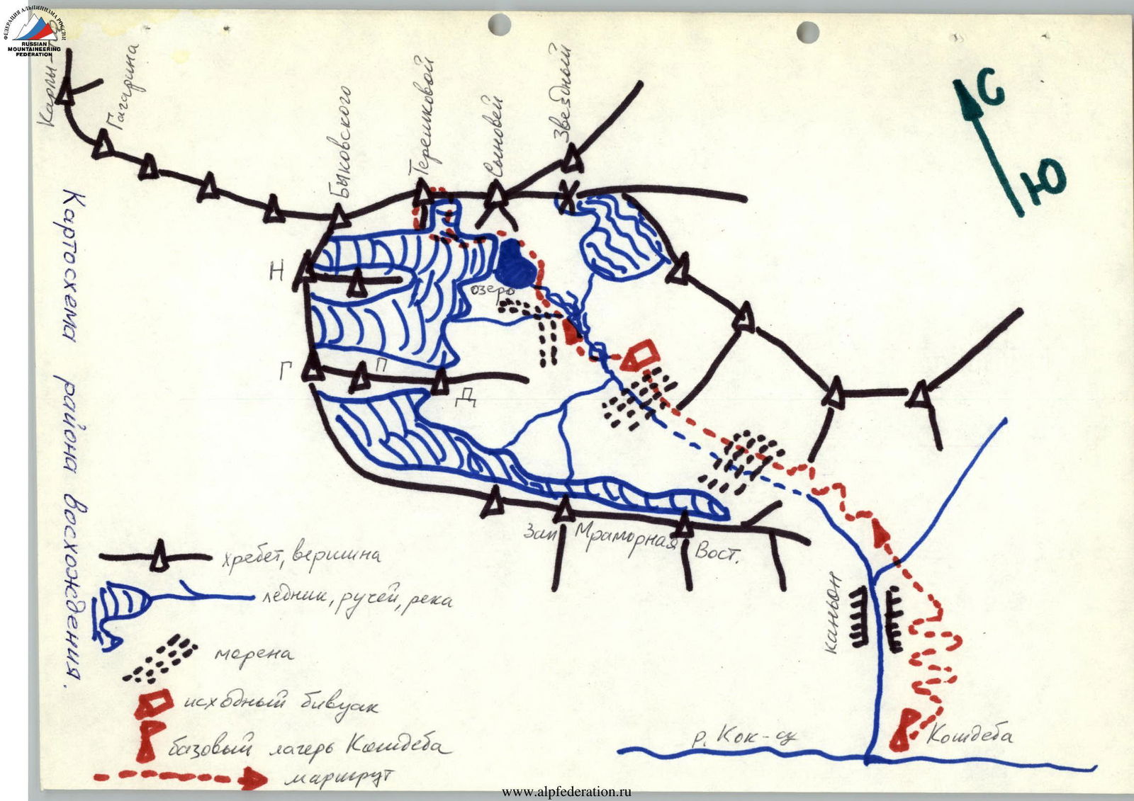
Map of the ascent area

Appendix No. 2
| Designation | Average steepness, ° | Length, m | Terrain characteristics | Difficulty | Condition | Weather conditions | Belaying (rock) | Belaying (ice) | Belaying (bolts) | Passage (rock) | Passage (ice) | Passage (bolts) | Time of departure and stops at bivouacs, travel hours, overnight stay conditions |
|---|---|---|---|---|---|---|---|---|---|---|---|---|---|
| R0–R1 | 60 | 80 | slabs | 4 | monolith | clear | 5 | – | – | – | – | – | Departure at 7:00. 1 hour |
| R1–R2 | 30 | 40 | scree slopes | 2 | monolith | – | – | – | – | – | – | – | 0.2 hours |
| R2–R3 | 60 | 40 | chimney | 4 | rock crumbles under load | – | 3 | – | – | – | – | – | 0.5 hours |
| R3–R4 | 80 | 10 | chimney | 5 | monolith with hoarfrost | – | 5 | 1 | – | – | – | – | 0.5 hours |
| R4–R5 | 70 | 80 | monolith with sloping holds | 5 | wall | – | 5 | – | – | – | – | – | 1.5 hours |
| R5–R6 | 65 | 20 | crevice | 4 | monolith | – | 2 | – | – | – | – | – | 0.25 hours |
| R6–R7 | 80 | 20 | cork chimney | 5 | wet rocks | – | 2 outcrops | – | – | – | – | – | 0.5 hours |
| R7–R8 | 45 | 100 | ridge | 3–4 | monolith | – | 4 outcrops | – | – | – | – | – | 1 hour |
| R8–R9 | 65 | 100 | internal corner | 4 | monolith with sloping holds | – | 5 | – | – | – | – | – | 1 hour |
| R9–R10 | 50 | 80 | wall | 4 | monolith, cracks | – | 4 | – | – | – | – | – | 1 hour |
| R10–R11 | 35 | 100 | ledges, gendarmes | 2 | crumbling live rocks | – | outcrops | – | – | – | – | – | 0.5 hours, reaching the summit at 15:00 |
Brief description of the approach to the route
From the Kosjdeba meadow, ascend up the river to the confluence of two streams (2 hours). From the confluence, follow the right stream (orographically), on the right bank (in the direction of travel) to the initial bivouac on a green site behind the moraine (1.5 hours). There is a stream here. From the initial bivouac, a gentle ascent along the stream, bypassing the moraines on the right in the direction of travel. To the snow — 1 hour, on a gentle snowfield — 0.5 hours.
Brief explanation for the table (Appendix No. 2)
Section R0–R1
The start of the route is under a smoothed rock wall with black streaks (on the right above, a characteristic triangular snow patch). Ascend up the smoothed slabs to a wide ledge, covered with sand, to the left of the triangular snow patch.
Section R1–R2
Move left and up from the ledge along gentle slabs to an internal corner with three characteristic rocks. Continue strictly vertically until reaching the ridge near the break-off.
Section R2–R3
Climb the chimney to the 2nd round rock; climbing in shoes on friction, often with holds in the form of conglomerate crumbling under load.
Section R3–R4
From the 2nd rock, climb the chimney with bridging for 10 m, bypassing the 3rd rock on the right; in the cracks, there is hoarfrost covered with sand (1st key point).
Section R4–R5
- From the 3rd rock, exit to a smooth slab.
- Climb up it 80 m to a crevice leading to a wide internal corner.
- Tense climbing with few cracks for pitons, sloping holds (on friction), sometimes covered with sand.
Section R5–R6
- Through the crevice into a wide internal corner transitioning into a chimney.
Section R6–R7
- Climb the chimney with bridging.
- Complex exit from under the cork on the right for 10 m (2nd key point).
- Above the cork, on the left, there is a convenient platform for belaying; the entire group can be taken here.
- From the platform, 10 m exit to the ridge near the break-off.
Section R7–R8
- Along the pronounced ridge (climbing on friction).
- Exit to a gentler section of the ridge, onto a 3 m wide platform.
Section R8–R9
- From the platform, 100 m along an internal corner, climbing on friction.
Section R9–R10
- The internal corner leads to a pre-summit wall; climb the wall to gendarmes.
Section R10–R11
- In the gendarmes zone, move simultaneously, belaying on outcrops.
- Many live rocks!
Description of the descent from the summit
The descent follows the eastern scree ridge to the saddle between Terekhova Peak and Syinovya Peak. From the saddle, descend to the glacier towards the initial bivouac along scree, and then on a snowfield. Ice axe belay is mandatory! The descent takes 1 hour.
The group assesses the complexity of the route as 4B category.