Ascent Passport
- Climbing category: technical
- Region: Pamir-Alay
- Peak: Pik Synovey, 5100 m, via the central buttress of the southwest wall
- Difficulty category: 5A
- Route characteristics: rock climbing, elevation gain — 650 m, average slope — 65°, section lengths: 1 — none, 2 — none, 3 — 320 m, 4 — 260 m, 5 — 170 m, 6 — 5 m
- Pitons used: for belaying: rock 52, ice 0, bolted 0 for creating artificial holds: rock 2, ice 0, bolted 0
- Climbing time: 11 hours
- Number of bivouacs: none
- Leader: Sayfutdinov R. M. — 1st sports category
Participants:
- Novikov V. P. — 1st sports category
- Vyaz'min S. A. — CMS, 2nd category instructor
- Ivanov A. V. — 1st sports category, 3rd category instructor
- Coach: Fedorov A. S. — MS, 1st category instructor
- Date of departure and return: July 9, 1980
Route Description
to Pik Synovey, 5100 m, via the central buttress of the southwest wall, 5A category (approximate)
Approach
From the Alay tourist camp (Koshtsyba meadow) upstream along the left orographic bank of the Kashka-Su River for 3 hours to bivouac on gentle moraine ridges in the upper reaches of the gorge. From the bivouac, 1 hour to the wall of Pik Synovey.
The central buttress is clearly visible. It is bounded on both sides by large rock couloirs filled with snow.
The start of the route is a narrow rock couloir filled with snow and ice, about 160–180 m long, dividing the buttress into two unequal parts.
Section R0–R1
Enter the lower third of the couloir from the right via a steep snow slope (45–50°) and a 5–6 m wall (grade 4) with a slope of 50°. The wall has piton protection.
Section R1–R2
Continue up the couloir for 40 m (slope up to 55°, piton protection, rock or ice pitons) to the base of a rock chimney with a stone plug at the top, leading left and up.
Section R2–R3
Ascend the chimney for 35 m (caution! loose rocks!). Rock grade 5. Slope 80–85°. The chimney ends at a ledge. The ledge has the 1st control cairn. From the start of the route, 2–3 hours.
Section R3–R4
Traverse 4 m left along the ledge to the base of an internal corner. Ascend the corner for 35 m to the next ledge below a steep rise in the buttress. Corner slope 55–60°, climbing grade 4. Piton protection.
Section R4–R5
Bypass the rise to the right via smooth rocks for 40 m (piton protection) and exit into a wide rock couloir with snow. Section slope 50–55°. Rock grade 4.
Section R5–R6
Ascend right and up, crossing the couloir towards a rock wall bounding the couloir on the right (40 m). From under the wall, move left and up through the couloir (snow, ice) for another 40 m to rock outcrops at its upper end. Continue up complex, loose rocks (caution! rocks!) for another 40 m to a col between two characteristic "cucumber"-shaped gendarmes (piton protection, section slope 55–65°, rock grade 5). Before reaching the col, traverse right onto a gentle rock section with the 2nd control cairn. From the 1st control cairn, 2–3 hours. Above the "cucumbers," a 20 m sloping, scree-covered ledge provides a good bivouac site.
Section R6–R7
From the scree-covered ledge, ascend right up a rock wall for 20–25 m to a pronounced ridge. Wall slope 80–85°. Rock grade 5. Piton protection.
Section R7–R8
From the ridge, traverse right for about 30 m along smooth rocks into a wide rock couloir with snow, leading to the base of the western wall of the buttress, and ascend the couloir for 40 m. Couloir slope 55–60°. Piton protection, rock grade 4. From the start of the route, 6–8 hours.
Section R8–R9
Key section of the route: a 35 m wall with a slope of 75–80°. Rock grade 5–6. A distinctive feature of the wall is a rock arch that must be passed under. Ascend the wall with careful piton protection (about 5 m of artificial holds, 2 pitons) to the ridge of the buttress at the base of the summit "fan" — a very wide couloir descending from the summit tower between the central buttress and the western wall of the southern ridge. This section takes 1.5–2 hours.
Section R9–R10
From the buttress ridge, traverse 40 m along complex rocks (grade 5) with a characteristic 5–6 m deep crevice — into the "fan's" throat (piton protection). Caution! In the afternoon, the throat may be subject to a rockfall of small, wet stones!
Section R10–R11
From the "fan's" throat, ascend directly up one of its characteristic ridge formations to the summit. The lower part of the ridge has a highly developed structure (about 120 m). Here, protection is via rock outcrops. Higher up, the ridge becomes smoother, requiring piton protection (about 120 m). Rock grade 3. The upper part of the "fan" consists of a fine and very steep "live" scree. Moving across such scree is extremely difficult (about 80 m). Here, protection is via isolated rock outcrops. The scree leads directly to the summit. Section slope up to 45°. From the key section, 1.5–2 hours.
Descent
Descend via the straightforward southern ridge towards Pik Zvezdny in the Kashka-Su gorge. To the original bivouac, 2–2.5 hours.
Route Notes:
- The route is generally not rockfall-prone and can be climbed at any time of day.
- The entire route features limestone rocks that are extremely unstable and easily crumble. This significantly complicates the passage even of relatively gentle slopes (about 45°).
- In rainy conditions, the rocks become slippery and "soapy." This greatly complicates rock climbing and sharply increases the risk of falls. Therefore, climbing the route in rainy weather is not recommended.
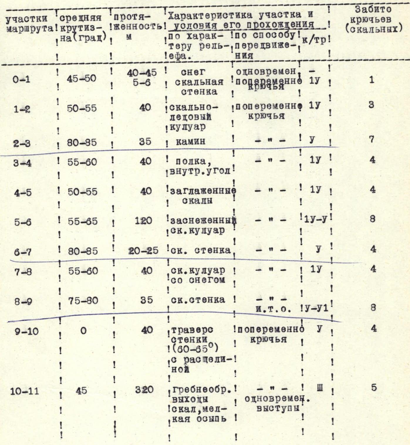
TABLE OF MAIN CHARACTERISTICS OF THE ASCENT ROUTE TO PIK SYNOVEY, 5100 M, VIA THE CENTRAL BUTTRESS OF THE SOUTHWEST WALL, 5A CATEGORY (APPROXIMATE)

Area Map
- – bivouac site,
- – group's path.
Start of the route. Sections:
- R0–R1
- R1–R2
- R2–R3
- R3–R4
— — — visible path · · · · · invisible path
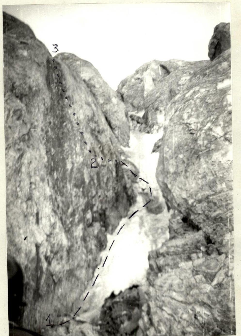
Route sections R1–R2 and R2–R3
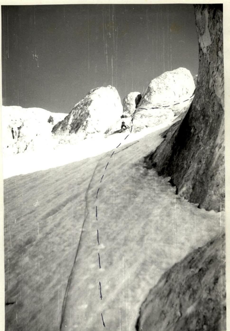
Upper part of section R5–R6. Against the sky, characteristic "cucumber"-shaped gendarmes are visible