Ascent Log
- Climbing category — rock climbing.
- Climbing area — southern spurs of the Alay mountain range, Levin'skaya Glacier.
- Peak, its height, ascent route — 50 let Uzbekistana, 4650 m, via the "sickle" of the N–E wall.
- Estimated difficulty category — 5B category, No. 453 dated February 28, 1978.
- Route characteristics — rock climbing, height difference 850 m, length of sections with 5–6 category difficulty 240 m, average steepness of the route 50°. Total length 1190 m.
- Number of pitons: for belaying, for creating artificial holds
| For belaying | For creating artificial holds | ||
|---|---|---|---|
| rock | — | 88 | 4 |
| ice | — | 2 | none |
| bolt | — | none | none |
- Number of travel hours — 21 hours.
- Number of overnight stays and their characteristics — one overnight stay, seated, water was absent, altitude of overnight stay 4400 m.
- Surname, name, patronymic of participants and their qualification:
- Kudryashov V. S. — 1st sports category
- Chernyaev A. I. — 1st sports category
- Team coach — Kudryashov V. S.
- Date of departure and return:
Departure — August 18, 1977.
Return — August 19, 1977.
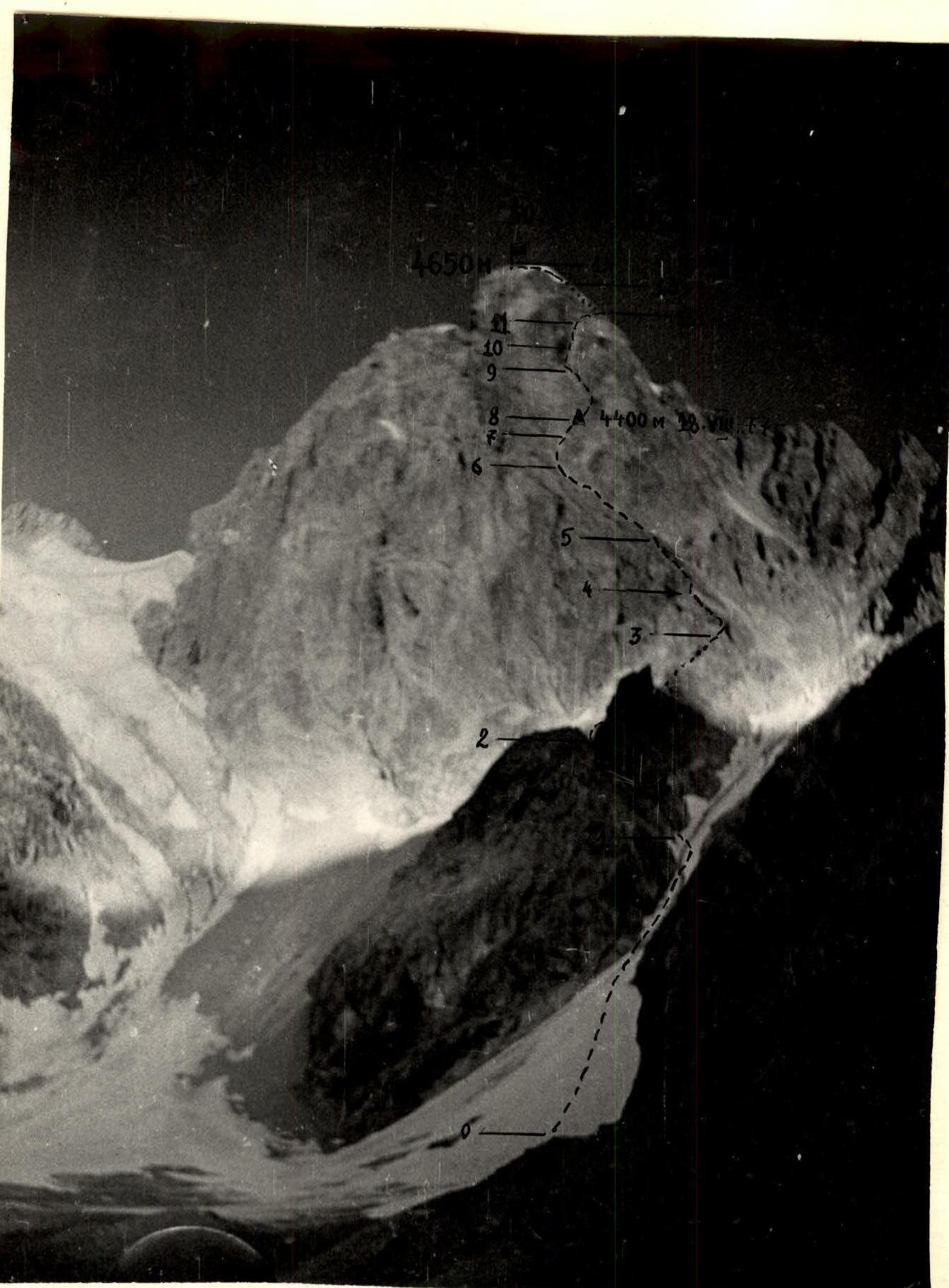
Photo of the general view of the peak.
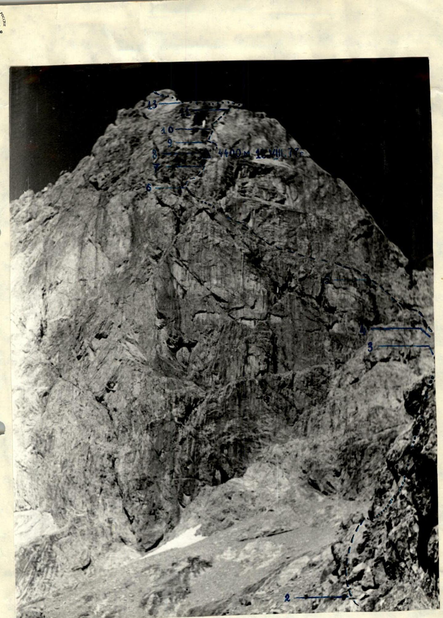
Photo of the general view of the route.
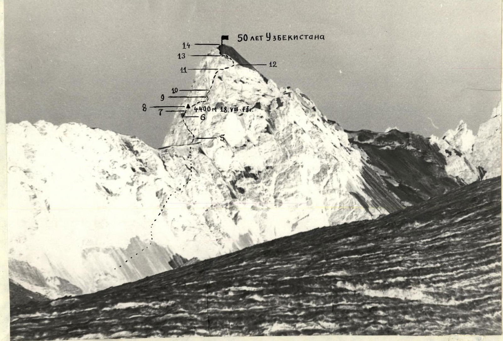
Photo of the route profile.
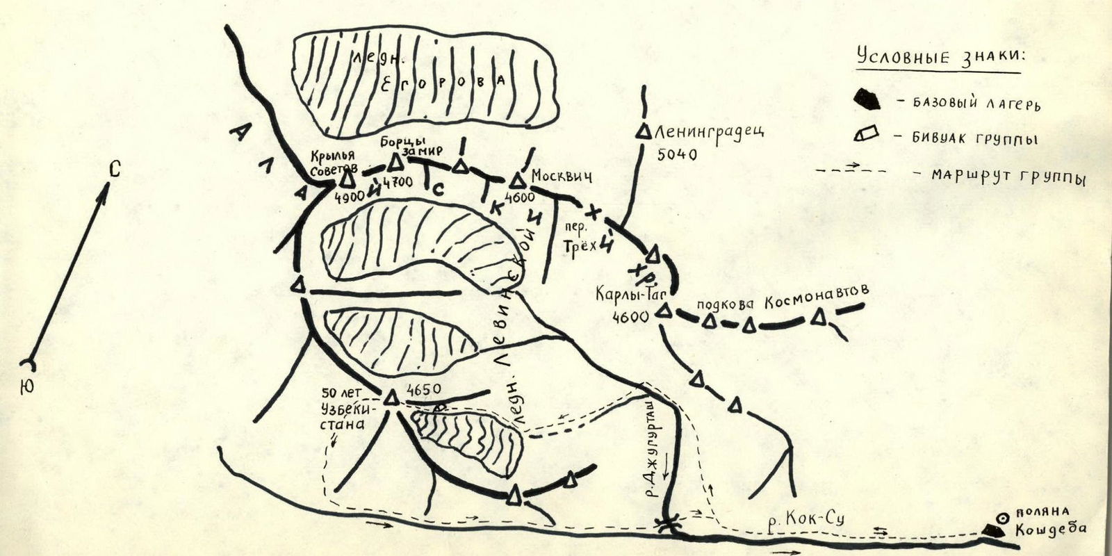
Climbing Area Map
Appendix No. 2
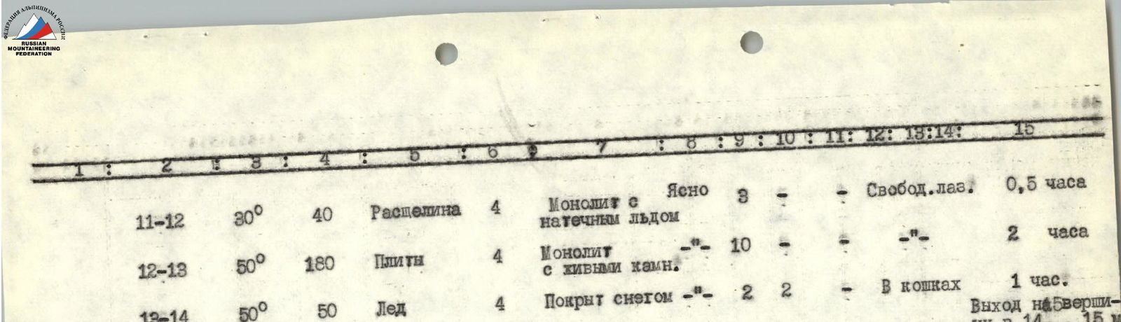
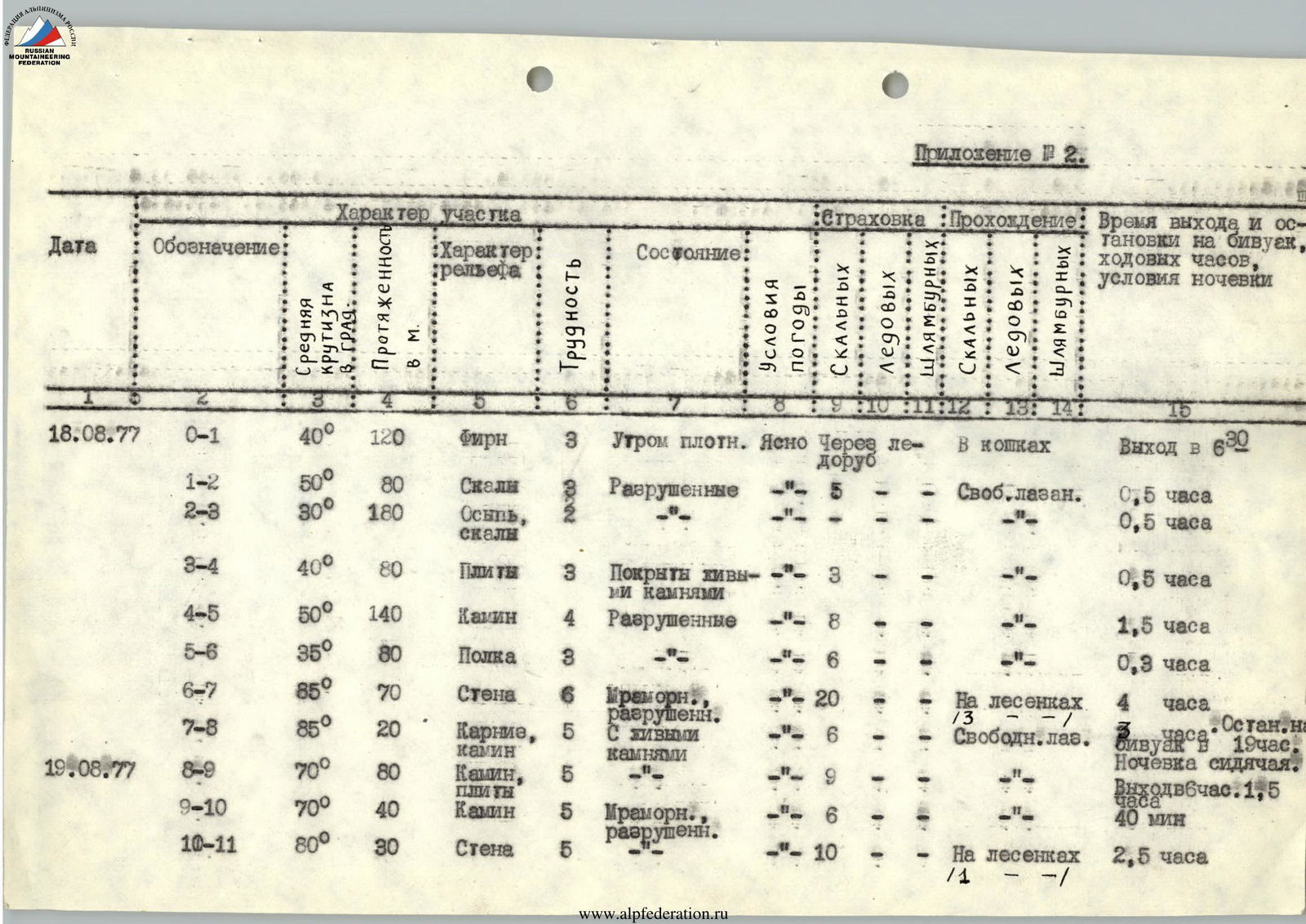
| Date | Designation | Average steepness | Length in m. | Terrain characteristics | Difficulty | Condition: | Weather conditions | Belay: rock | Belay: ice | Belay: bolt | Passage: rock | Passage: ice | Passage: bolt | Time of departure and stop for bivouac, travel hours, bivouac conditions |
|---|---|---|---|---|---|---|---|---|---|---|---|---|---|---|
| 18.08.77 | R0–R1 | 40° | 120 | Firn | 3 | Firm in the morning | Clear | Via ice axe | In crampons | Departure at 6:30 | ||||
| R1–R2 | 50° | 80 | Rocks | 2 | Loose | — | 5 | Free climbing | 0.5 hours | |||||
| R2–R3 | 30° | 180 | Scree, rocks | 2 | — | 0.5 hours | ||||||||
| R3–R4 | 40° | 80 | Slabs | 3 | With live rocks | — | 3 | 0.5 hours | ||||||
| R4–R5 | 50° | 140 | Chimney | 4 | Loose | — | 8 | 1.5 hours | ||||||
| R5–R6 | 35° | 80 | Ledge | 3 | — | 6 | 0.3 hours | |||||||
| R6–R7 | 85° | 70 | Wall | 6 | Marble, loose | — | 20 | On ladders 3 | 4 hours | |||||
| R7–R8 | 85° | 20 | Cornice, chimney | 5 | With live rocks | — | 6 | Free climbing | Stop for bivouac at 19:00. Sitting bivouac. | |||||
| 19.08.77 | R8–R9 | 70° | 80 | Chimney, slabs | 5 | — | 9 | Departure at 6:00, 1.5 hours | ||||||
| R9–R10 | 70° | 40 | Chimney | 5 | Marble, loose | — | 6 | 40 minutes | ||||||
| R10–R11 | 80° | 30 | Wall | 5 | — | 10 | On ladders 1 | 2.5 hours | ||||||
| R11–R12 | 30° | 40 | Cleft | 4 | Monolith with ice | Clear | 3 | Free climbing | 0.5 hours | |||||
| R12–R13 | 50° | 180 | Slabs | 4 | Monolith with live rocks | — | 10 | 2 hours | ||||||
| R13–R14 | 50° | 50 | Ice | 4 | Covered with snow | — | 2 | 2 | In crampons | 1 hour. Summit at 14:15 |
Brief Description of the Approach Route
To the Route
From the base camp at Koschdeba meadow, ascend up the left (orographically) side of the Kok-Su valley to the bridge over the Dzhugurtam River (2–2.5 hours). Without crossing the bridge, turn right and ascend along the trail along the left (orographically) bank of the Dzhugurtyash River to a characteristic flat stony valley (1–1.5 hours). Reaching the narrowing of the valley, turn left and ascend to the first (on the way) cirque of the Levin'skaya Glacier along the left lateral moraine of the glacier to a characteristic sinkhole lake in the cirque (1–1.5 hours).
Here is a convenient place for an overnight stay, with a good view of the entire route. We found traces of Shumilov's group's bivouac (20-liter canister, pots, helmets...).
Brief Explanation of the Table (Appendix No. 2)
Section R0–R1
From the bivouac, exit to the base of the long snowy couloir to the right of the "sickle" via the moraine. Ascend the couloir in crampons (firm firn) with alternating belay to the rocky couloir cutting through the lower part of the "sickle". Pass the snowy couloir in the morning before 7:30 (rockfall hazard!).
Section R1–R2
Pass the rocky couloir on the left side with careful piton belay, as its bottom is filled with "live" rocks. The couloir leads to an osypnaya terrace in the lower part of the "sickle".
Section R2–R3
The terrace leads to a long inclined slab, which we pass with simultaneous belay, leaving the "sickle" ridge to the right. Through a small chimney, we exit to the "sickle" ridge at the point where it turns south.
Section R3–R4
The steepness of the "sickle" ridge increases here, it becomes slab-like, with piton belay. Along the slabs, we approach the wall leading to the upper part of the "sickle". Under the bridge connecting the slabs to the wall, we set up the 1st control cairn.
Section R4–R5
The lower part of the wall is sheer (2 m). Then we move along an inclined leftward chimney cutting through the wall. The chimney leads to the upper part of the "sickle", which is a wide ledge with a series of alternating ledges of 2–3 m. The steepness of the ledge is about 35°.
Section R5–R6
Moving along the ledge and overcoming the encountered ledges, we exit to the base of a large internal angle. This is the base of the summit bastion, the first key section.
Section R6–R7
The left side of the angle features smooth marble rocks overhanging at the top. Huge ice icicles hang from above, constantly dripping water. The entire left part of the angle and the middle of its lower part are flooded with this water. The only ascent option is along the center of the right side of the internal angle, deviating left under a cornice (1.5 m) covering the internal angle from above. The wall is almost vertical and has slight overhangs. Climbing is tense, with difficult piton placements. We take about 4 hours to climb the 70 m wall, alternating the lead climber. We pull the backpacks in two stages: to the middle of the wall and further under the cornice.
Section R7–R8
We pass the cornice on the left through a narrow cleft between it and the left side of the internal angle. Climbing is very tense due to the cleft being filled with "live" rocks. 2–3 m of smooth rocks without holds, forming the cornice's eaves, lead to a narrow chimney (a continuation of the internal angle). The chimney's walls are vertical, converging at the top to form a slight overhang. It starts getting dark, so we decide to set up a bivouac.
One of us settles on a small platform, while the other has to hang in a rope seat. We manage to pull out only one backpack from under the cornice, leaving the second one with the stove. Still, there's no water. We spend the night fairly well, it's warm.
Section R8–R9
The second day of the route begins with pulling out the second backpack. We pass the chimney along the ridge of its right wall, which is composed of loose marble rocks that crumble under load. Climbing is tense. Further along the continuation of the chimney, we exit to a corrie on the wall of the summit tower. Finally, we can sit down and pull the backpacks.
Section R9–R10
The corrie is a triangular inclined osypnaya ledge with a downward slope to the central part of the N–E wall. To the left of the corrie, a steep marble slab rises, abutting the wall of the summit tower. A couloir ascends upward through the center, overhanging with walls from which huge icicles hang. This ascent option is hazardous due to rockfall and icefall occurring every 5–10 minutes.
The only remaining ascent option is along the internal angle deviating rightward and upward from the corrie. From the corrie, we ascend along the lower chimney-like part of the internal angle to a slight overhang, where we can shelter from rocks and ice falling from the couloir.
Section R10–R11
From under the overhang, we move leftward and upward along a steep wall leading to the wider part of the internal angle. Further ascent goes toward the center of the angle. The lower part is vertical; we use a ladder. The internal angle becomes less steep, and we exit under the cornice of the summit tower. We pull the backpacks.
Section R11–R12
The cornice is bypassed rightward and upward through a cleft, which transitions into a narrow horizontal ledge after a few meters. Directly above us are steep (45–50°) slabs of the summit ascent.
Section R12–R13
We pass the slabs first from left to right upward, then from right to left to a tongue of ice leading to the summit.
Section R13–R14
In crampons, we ascend the ice and reach the summit in 2–2.5 rope lengths.
Description of the Descent from the Summit
The descent from the summit follows the western ridge to a saddle with a neighboring peak via a 3×40 m "dülfer" rappel. Then, we descend along scree with a sharp height difference toward the Kok-Su valley to the trail. The descent takes 3 hours.
The group assesses the difficulty of the climbed route as 5B category. For safety reasons, they recommend climbing the route in pairs.


