PASSPORT
Ascent to v.Yu.Ossonoli (4685 m)
- Ascent class — technical.
- Ascent area — Southern spurs of the Alay ridge, Kok-Su valley.
- Peak "4685" — the proposed name is South Ossonoli.
- Proposed difficulty category — 5B.
- Route characteristics.
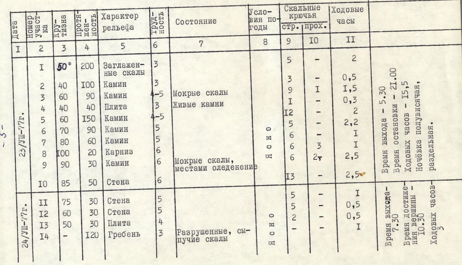
Height difference 4685–3910 = 775 m. Length of sections 5B cat. difficulty — 300 m, 6 cat. difficulty — 100 m. Average steepness — 60°.
- Rock hooks hammered for belay — 78, for creating I.T.O. — 4. Ice and bolt hooks were not used.
- Number of travel hours — 18.5.
- One overnight stay, separated, semi-hanging.
- Team composition:
KOLCHIN Alexander Alexandrovich — MSMK, BALYBERDIN Vladimir Sergeevich — CMS, not registered. 10. Team coaches:
KORKIN Igor Vasilyevich, KOLCHIN Alexander Alexandrovich. 11. Date of departure on the route August 23, 1977 return August 24, 1977
TABLE OF MAIN ROUTE CHARACTERISTICS
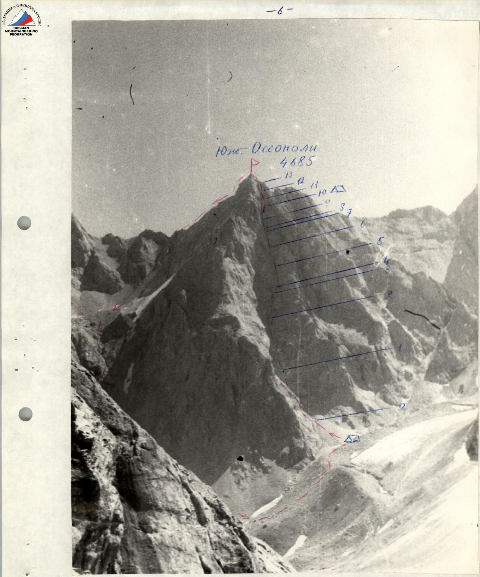
Western wall of the peak South Ossonoli.
View from the summit Tekelik.
Description of the peak and approaches.
The peak "4685" is located in the southeastern corner of the Tekelik cirque. The entire massif "4685" and "4805" is called Ossonoli by the Kyrgyz, and the pass leading to the Tekelik gorge is called the Ossonoli pass. We propose to call the peak "4685" — South Ossonoli.
Approaches from the a/l "Alay" (Koshdyba clearing) pass along the trail along the left (orographic) bank of the Kok-Su. In the Dzhugur-Tash tract, there is a transition to the right bank along the scree and further to the Ossonoli stream (flowing from the Tekelik cirque). Up this stream to the clearing under the tongue of the Tekelik glacier (height 3600 m). By-passing the glacier tongue on the left along the stream, exit to the lateral moraine of the glacier flowing from the Ossonoli pass (we propose to call the Ossonoli glacier). On the moraine under the western wall of the peak — a bivouac.
From the bivouac, a chimney is clearly visible, going along the center of the western wall directly to the summit. The wall is composed of marbleized limestones, and the chimney is formed as a result of the destruction of a dyke from diabase porphyrite.
Description of the Ossonoli route.
(Addition to the table of the main characteristics of the route). The route begins along steep marble slabs leading to the beginning of the chimney. For some time, while the slabs are still gentle (section R1), it is easier to move along the slabs than along the cleft, which further turns into a chimney. Belay is hook-based.
Then it turns into a cleft-chimney, which looks like a dry riverbed (with a small stream) (section R2). Gradually, the cleft takes the form of a chimney 2–2.5 m wide, the average steepness increases. The side walls of the chimney are made of smooth marble, the inner ones are made of destroyed dark green porphyrite.
At the place where the chimney is divided into 3 chimneys:
- we passed along the left one (30 m) to a rock shelf (R4);
- along the shelf traverse back to the right one.
It is the right one that continues as the main chimney. On the shelf under the overhang — a control cairn.
Further, inside the chimney, for 300 m, the rocks are a stepped ladder with sheer difficult steps and relatively gentle shelves filled with fine sand. The rocks are wet, climbing purely by chimney method is difficult, as the side walls are very smooth. Belay is hook-based, mainly using the gaps between the marble and the dyke. An ice axe of the VTsSPS type is often used.
Gradually, the overall steepness increases due to the reduction of the shelves (sections R5–R7). In several places there are areas sheltered from stones, which are convenient to use for belay.
Special sections:
- a large jammed stone ("plug") is bypassed on the right (R8);
- behind the plug, the inside of the chimney is filled with ice, but the walls have some relief and cracks for hooks appear in them;
- further, the character of the chimney is preserved, a new ice plug hangs at the top.
Due to the increased danger of stones in the evening, when the western wall is lit by the sun, the group preferred to exit the chimney to the right and move directly along the smooth wall 5–10 m from the edge of the chimney (R10). Here, on the wall, the group was caught by darkness, and a separate, semi-hanging bivouac was organized on shelves ~15 cm wide.
Further, the wall gradually becomes gentler (sections R11–R12) and turns into a slab under the ridge of the summit (R13). Along a simple, heavily destroyed ridge — ascent to the summit (R14).
Descent from the summit.
The descent from the summit passes along the northern ridge to the saddle with v. North Ossonoli (ridge ~3 cat. difficulty, 1.5–2 hours) and further:
- along the scree gully to the west into a large scree cirque;
- again along the scree gully into the Tekelik cirque.
Route assessment.
The group believes that the difficulties of the key sections of the route surpass all the routes of 5B cat. difficulty passed by the participants. 100 m of the route (sections R8–R10) are similar to the most difficult sections of the western wall of Bodkhona 6 cat. difficulty. The group asks to evaluate the route 5B cat. difficulty.
Recommendations for subsequent groups.
- Pass the route in a team of two.
- Have as little gear as possible.
- On the route, even at the end of August, individual stones move along the chimney. Probably, at the beginning of summer, when there is more ice on the upper ridge and in the chimney, the route is even more stone-hazardous.