Ascent Passport
- Climbing category: technical
- Climbing area: Southern spurs of the Alay ridge, Kок-Су gorge.
- Peak 4630 m, via the center of the NW wall
- Proposed difficulty category 5A
- Route characteristics:
Elevation gain 700 m, length of sections with 5th category difficulty 130 m, average wall slope 80°
- Protection anchors installed
rock anchors 35, ice anchors 1, used slings with carabiners 21
- Total climbing time 14.5 hours
- No overnight stays
- Participants: Kolchin Alexander Alexandrovich Master of Sports of International Class
Razumov Yuri Mikhailovich Candidate for Master of Sports 10. Coach: Kolchin A.A. 11. Departure from the bivouac on August 8, 1977 at 6:00 AM
 Map of the climbing area.
1 km.
www.alpfederation.ru↗
Map of the climbing area.
1 km.
www.alpfederation.ru↗
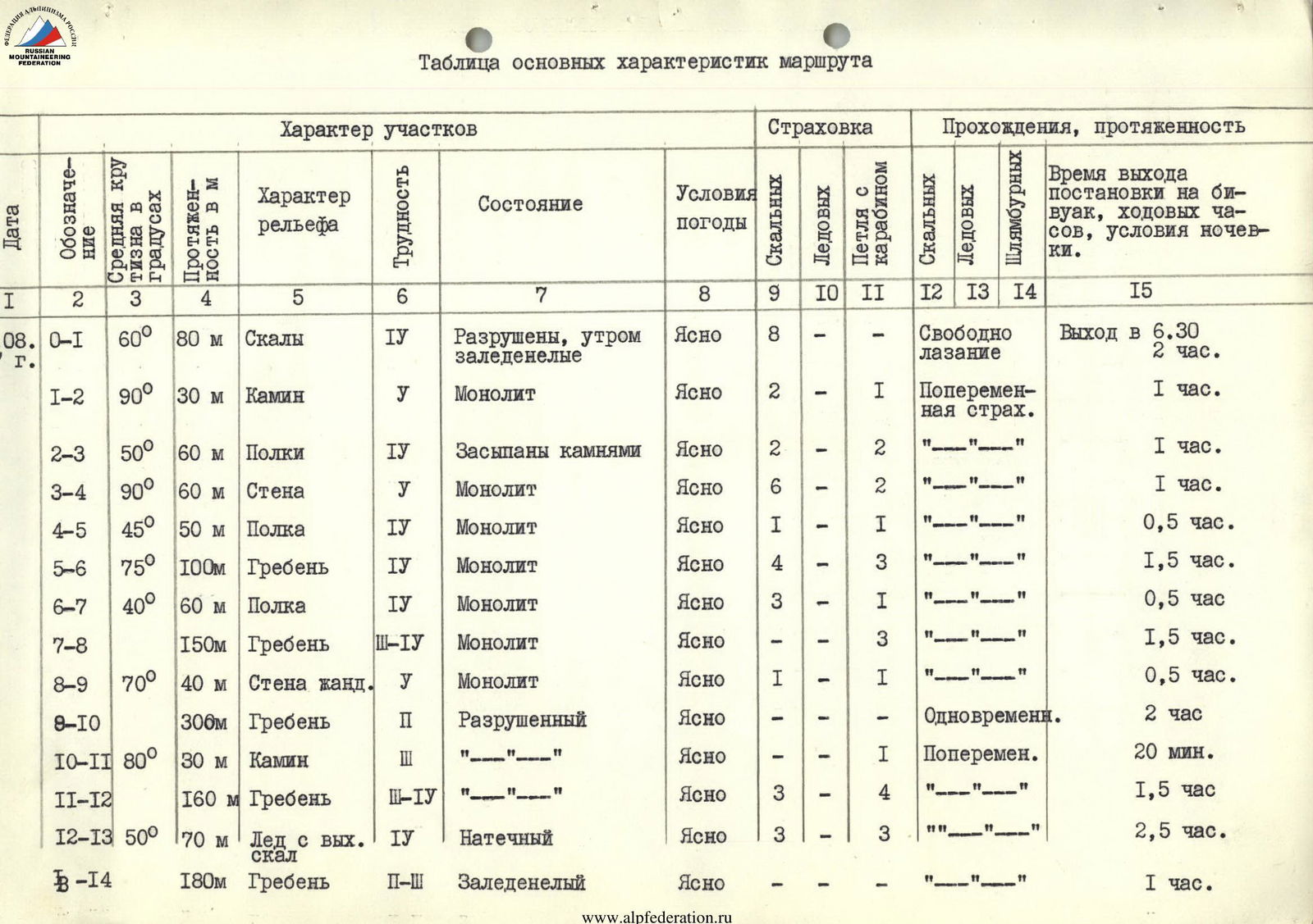
Table of main route characteristics
Approach description
Path along the terrace from the Koshdyba meadow up the Shah-dar tract. Keeping to the right (in the direction of travel) side of the gorge, ascend along sheep trails along the stream to the glacier, covered with surface moraine. Then along this moraine straight to the end. Here is a convenient place for a bivouac.
Route description
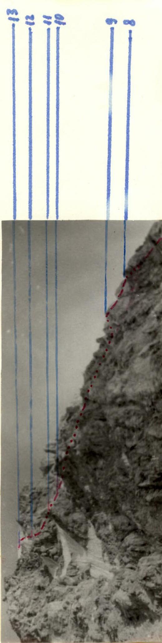
From the peak 4630 m, several ridges and counterforts extend to the north and northwest. One of them ends with a large steep triangular wall. This wall, along with the northeastern ridge from the peak 4708 m, forms characteristic "gates" - a narrowing of the glacier flowing out of the upper cirque.
The entire northwest wall is divided by two large sheer couloirs into three bastions:
- Water flows and stones fly through the couloirs.
- The middle bastion ends with a characteristic "paw".
The route begins from the left part of the "paw" (section R0–R1) under a chimney clearly visible from the glacier (section R1–R2).
Behind the chimney:
- along the ledges to the right to the end of the "paw" (section R2–R3)
- then straight up the wall (section R3–R4) to a large rock mulde
- then left along an inclined ledge (section R4–R5) to a steep counterfort
At the end of the ledge - a control cairn.
Then:
- up the counterfort (section R5–R6)
- two snow-ice slabs remain on the left.
- then along the ledge to the right (section R6–R7) to the exit to the main Northwest ridge
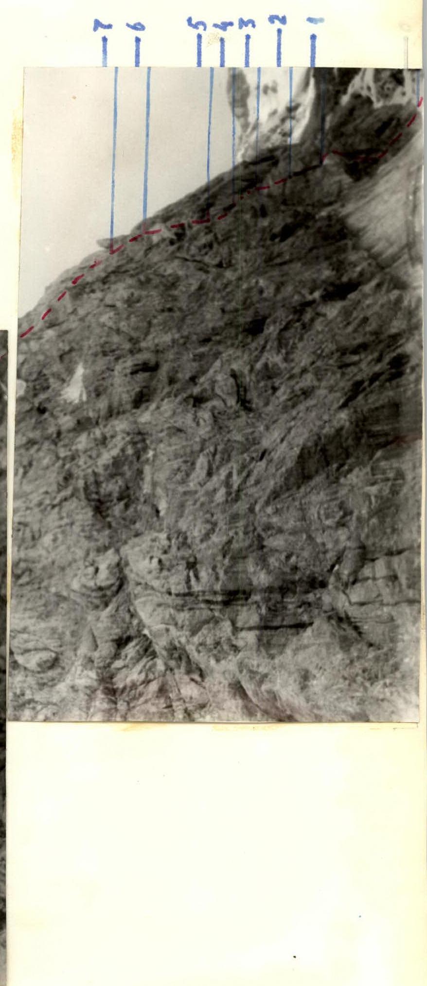
Then:
- along the complex ridge (section R7–R8) to the sheer white wall of the gendarme, which is climbed directly head-on (section R8–R9)
- descent from the gendarme to the right onto a ledge
- then a large section of the ridge (section R9–R10) is traversed on the right side of the ridge along the ledges to a large gendarme with a chimney (section R10–R11) in the middle part
Then:
- the ridge becomes steeper and ice sections appear on it (section R11–R12).
- the ridge leads to a steep ice slope.
- up to the junction of the Northwest and West ridges.
Our group traversed left and up (section R12–R13) with an exit to a small scree leading to the pre-summit ridge.
Completion of the route:
- Along the ridge to the summit (section R13–R14).
Descent from the summit
Descent from the summit along the ascent route to the junction of the West and Northwest ridges. From the col, a red-gray scree couloir is visible. In the middle part of the couloir - a narrowing filled with ice. Descent should be done with caution, keeping to the right part along the ledges. Then again exit into the couloir and descend into the upper cirque, from where along the glacier to the bivouac on the glacier.
Descent from the summit to the bivouac takes 1.5-2.0 hours. www.alpfederation.ru↗