Ascent Passport
- Ascent class — TECHNICAL
- Ascent area — PAMIR-ALAY, ALAYSKY RANGE, KOK-SU VALLEY
- Peak, its height, and ascent route — p. YANA KREUSA, 4634 m, RIGHT EDGE OF THE SOUTHERN WALL CHIMNEY
- Difficulty category — 5B
- Route characteristics: the route is rocky, with an altitude difference of 850 m, wall section 485 m, total length 1230 m. Length of sections with 5th difficulty category — 400 m, 6th difficulty category — 52 m. Average steepness of the route — 50° — wall — 80°
- Pitons used: rock — 78, ice — –, bolted — –, chocks — 12
- Total climbing hours — 25 hours
- Number of bivouacs and their characteristics: two bivouacs with lying positions: the first one on a meadow under the wall, the second on a ledge
- Full name of the leader, participants, and their qualifications:
- Rodivilov Vladimir Ivanovich, Candidate Master of Sports — leader
- Tinin Yuri Pavlovich, Candidate Master of Sports — participant
- Shibanov Alexander Viktorovich, 1st sports category
- Yanchenkov Viktor Fedorovich, 1st sports category
- Team coach: Kavunenko Vladimir Dmitrievich, Master of Sports of International Class.
- Date of departure — August 18, 1980, return — August 20, 1980.
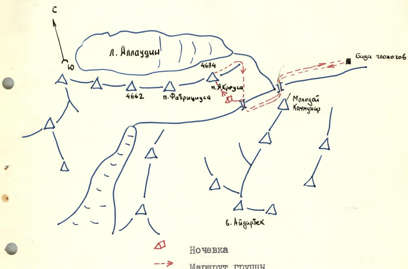
Area Map
Brief Geographical Description of the Area and Characteristics of the Ascent Object
The massif of peak 4643 (Yana Kreusa) is located in the southern spurs of the Alaysky Range, in the Kok-su river valley.
Peak Ya. Kreusa is the easternmost peak in the Short Spur of the Alaysky Range. To the west of the peak is peak Ya. Fabricius, 4820 m, to the north of this spur is the Alaudin glacier, and to the southwest is the Kok-su river valley.
Peak Ya. Kreusa has a pronounced pyramidal shape. To the west, the massif is separated by a gap from the massif of p. Ya. Fabricius. Towards the Alaudin glacier, the massif of p. Ya. Kreusa is a series of rocky walls resembling faults and short, destroyed ridges.
To the east, p. Ya. Kreusa is a bifurcated ridge descending to the confluence of the Alaudin and Kok-su rivers. Directly from the summit, the main ridge continues. South of it is another ridge running parallel to the main one. This second ridge ends abruptly towards the Kok-su river in a powerful, steep, half-kilometer wall. The wall is dry, completely devoid of water, snow, and ice. The wall begins at an altitude of approximately 3750 m.
The predominant rocks in the area are granites and marbles. The massif of peak Ya. Kreusa is primarily composed of dark reddish granites.
Almost the entire Southern wall of p. Ya. Kreusa consists of monolithic and smooth rocks with a limited number of small footholds and cracks for pitons. A giant chimney runs through the entire wall. In 1977, a route of 5B category was laid along this chimney and further along the Eastern ridge. The right edge of the chimney is the most interesting in terms of sportsmanship.
Characteristics of the wall:
- Dry, completely devoid of water, snow, and ice.
- Begins at an altitude of approximately 3750 m.
- The rocks here are the steepest, in places vertical and overhanging.
- The rocks are predominantly monolithic, partially smooth.
- The altitude difference here is also the greatest.
The route along the right edge of the chimney is well-defined, logical, and objectively safe. The exit to the summit is along the ridge. Descent is along the Eastern ridge, via a route of 4A category. Practically the entire route is rocky.
The route to peak Ya. Kreusa along the right edge of the chimney on the Southern wall is undoubtedly the "strongest" route that can be laid on the Southern wall, due to:
- concentration of the most complex sections;
- steep wall;
- maximum steepness.
In sports terms, the route is of significant and undoubted interest for high-qualification sports groups with good rock climbing preparation.
Route Schedule by Days
August 18, 1980 — Approach to the route, processing of the lower part of the wall, descent of the team for the night. August 19, 1980 — Ascending the wall and reaching the "ledge," overnight stay on the "ledge." August 20, 1980 — Summiting peak YANA KREUSA and returning to the base camp.
Table of Main Route Characteristics
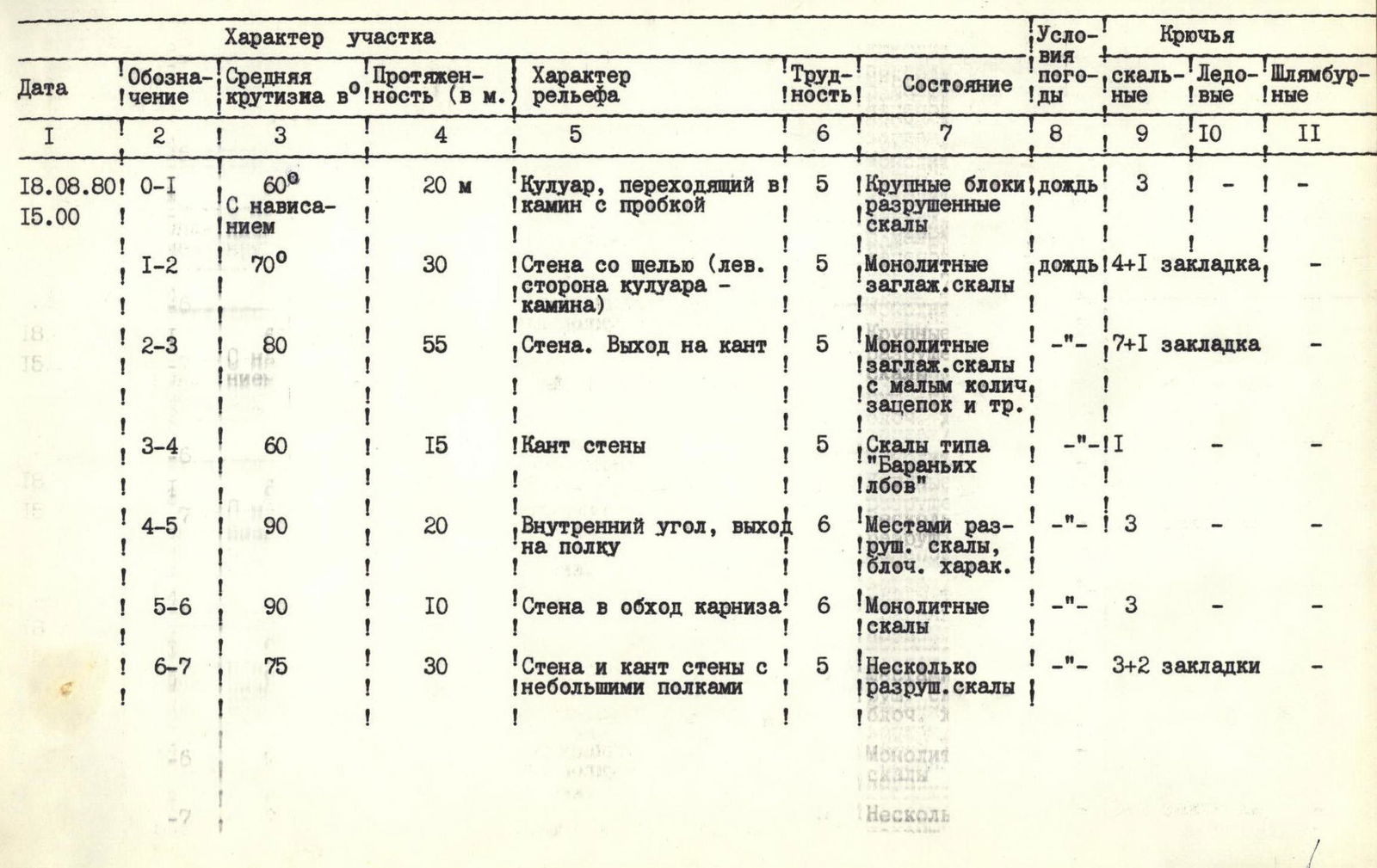
| № | Designation | Average Steepness in ° | Length (m) | Terrain Characteristics | Difficulty | Condition | Weather Conditions | Pitons: Rock | Pitons: Ice | Pitons: Bolted |
|---|---|---|---|---|---|---|---|---|---|---|
| 18.08.1980 | ||||||||||
| R0–R1 | 60° | 20 | Couloir turning into a chimney with a plug | 5 | Large blocks, destroyed rocks | Rain | 3 | – | – | |
| R1–R2 | 70° | 30 | Wall with a slit (left side of the couloir-chimney) | 5 | Monolithic smooth rocks | Rain | 4 + 1 chock | – | – | |
| R2–R3 | 80° | 55 | Wall, exit to the edge | 5 | Monolithic smooth rocks with few footholds and cracks | – | 7 + 1 chock | – | – | |
| R3–R4 | 60° | 15 | Edge of the wall | 5 | Rocks like "sheep's foreheads" | – | 1 | – | – | |
| R4–R5 | 90° | 20 | Inner corner, exit to a ledge | 6 | Partially destroyed rocks, blocky character | – | 3 | – | – | |
| R5–R6 | 90° | 10 | Wall bypassing the cornice | 6 | Monolithic rocks | – | 3 | – | – | |
| R6–R7 | 75° | 30 | Wall and edge of the wall with small ledges | 5 | Several destroyed rocks, blocky character | – | 3 + 2 chocks | – | – | |
| R7–R8 | 90° | 5 | Traverse left along the wall, exit to a ledge to the "Feathers" | 6 | Monolithic rocks with micro-footholds | Rain | 2 + chock | – | – | |
| 19.08.1980 | ||||||||||
| R8–R9 | 90° | 5 | Inner corner with a slit | 6 | Monolith | Clear | 2 | – | – | |
| R9–R10 | 75° | 15 | Wall | 5 | Smooth rocks | – | 2 | – | – | |
| R10–R11 | 70° | 6 | Traverse right, down | 4 | Rocks like "sheep's foreheads" | – | 1 | – | – | |
| R11–R12 | 85° | 15 | Wall | 5 | Smooth rocks | – | 3 | – | – | |
| R12–R13 | 65° | 20 | Right side of the inner corner | 5 | Slab-like rocks | – | 5 | – | – | |
| R13–R14 | 70° | 30 | Traverse right along a ledge, partially interrupted, and with small walls | 4 | Monolithic rocks | – | 3 | – | – | |
| R14–R15 | 95° | 7 | Traverse right along the wall | 6 | Monolithic walls with micro-footholds | Clear | 1, 1 chock | – | – | |
| R15–R16 | 60° | 20 | Exit to a balcony along a ledge | 3 | Destroyed rocks | – | Protrusions | – | – | |
| R16–R17 | 95° | 10 | Traverse right along the wall | 6 | Monolithic smooth rocks | – | 3, 1 chock | – | – | |
| R17–R18 | 90° | 20 | Wall with a 3-meter overhanging section | 6 | Monolithic, smooth rocks like "sheep's foreheads" | – | 3 | – | – | |
| R18–R19 | 70° | 40 | Wall, exit to a ledge | 5 | Monolithic rocks with good footholds | – | 5 | – | – | |
| R19–R20 | 80° | 30 | Wall with a wide slit | 5 | Monolithic rocks | – | 4 | – | – | |
| R20–R21 | 90° | 50 | Oblique chimney with a plug, exit to a scree ledge | 6 | Monolithic rocks with few footholds | – | 13, 4 chocks | – | – | |
| R21–R22 | – | 40 | Traverse right along a terrace | 2 | Scree terrace | – | – | – | – | |
| R22–R23 | 60° | 40 | Wall with ledges and short steep sections, exit to the ridge | 4 | Monolithic rocks with good footholds | – | 7 | – | – | |
| Stop for Bivouac at 17:00 | R23–R24 | 40° | 120 | Ridge with small walls, leading to a ledge | 3 | Destroyed rocks | – | Protrusions | – | – |
| 20.08.1980 | ||||||||||
| Departure at 7:00 | R24–R25 | – | 18 | Rappelling into a gap | – | – | Clear | 2 | – | – |
| R25–R26 | 60° | 40 | Small wall, exit to the ridge | 4 | Destroyed rocks | – | 4 | – | – | |
| R26–R27 | – | 300 | Ridge with a black-gray sentinel, bypassing to the right, exit to the summit tower | 3–4 | Heavily destroyed rocks | – | 9 | – | – | |
| R27–R28 | 45° | 150 | Wide ridge with scree ledges, exit to the pre-summit snow dome | 3 | Heavily destroyed rocks | – | 2 | – | Protrusions | |
| Summit Exit | R28–R29 | 45° | 80 | Snow slope, exit to the summit | 2 | Snow, destroyed rocks | – | – | – | – |
Route Description
The route begins with a couloir turning into a chimney (section R0–R1). The rocks of the chimney are monolithic and smooth. Throughout the chimney, several plugs are encountered, small and slightly overhanging. The chimney ends with a large overhanging plug. The plug is monolithic and is climbed with difficult free climbing, entering from the left.
The wall with a slit (section R1–R2) is ascended via the inner corner. In the upper part, the inner corner of the slab widens and turns into a large inner corner resembling a chimney. The walls of the inner corner are monolithic and smooth (section R2–R3).
After the inner corner, there is an exit left onto a steep rocky ridge, which is actually the right edge of the chimney of the Southern wall (section R3–R4). The rocks are strong. There are small ledges for:
- receiving participants;
- organizing reliable belays.
Then comes a large red slab with an inner corner (section R4–R5). The rocks of the slab are monolithic, with a very limited number of small footholds and cracks. Climbing is extremely difficult. It is ascended mainly along the corner, using footholds and cracks on the slab in some places.
The wall bypassing the cornice (section R5–R6) is ascended while adhering to the left side. Further up, along destroyed rocks, is the exit to the edge of the wall (section R6–R7). At the end of the edge, there is a traverse left along the wall and an exit to a ledge to the "Feathers" (section R7–R8). Climbing is very complex and strenuous. After processing the last section, the group rappelled down to the "meadow" by the river for the night.
On the second day, the group ascended via the fixed rope to section R8–R9, which is an inner corner with a slit. The rocks are monolithic, and climbing is strenuous. Then, a 15-meter wall (section R9–R10) is overcome, followed by a traverse right and down along smooth rocks like "sheep's foreheads." Further up, along a small wall, to a large inner corner (section R11–R12). The rocks are smooth, and climbing is difficult.
Along the right side of the large inner corner (section R12–R13) to a ledge and further along the ledge (section R13–R14), there is a traverse right to a 7-meter wall.
Traversing the wall to the right, there is an exit to a ledge (section R14–R15), then along the ledge to a balcony (section R15–R16). The wall is monolithic with micro-footholds, and climbing is very complex.
From the balcony, along monolithic smooth rocks, there is a traverse right along the wall (section R16–R17) and an exit to rocks like "sheep's foreheads." Section R17–R18 is a wall with a 3-meter overhanging section, climbed with difficult free climbing, using a pendulum 6 m towards the right edge. At the end of the wall, there is a large overhanging cornice. Climbing is extremely difficult and strenuous.
Then comes a 40-meter wall with an overhang at the end. It is ascended with a pendulum to the right under the overhang (section R18–R19). The wall with a wide slit is ascended along the right part of the slit (section R19–R20). The rocks are monolithic with good footholds.
Then comes a long chimney with a plug (section R20–R21). The walls of the chimney are close to vertical, in places overhanging. The rocks are monolithic. It is climbed on opposition. The chimney ends with a large overhanging plug. The rocks are heavily smooth. Climbing is very complex.
After the plug, there is a section of non-steep destroyed rocks (section R21–R22). After the destroyed rocks, the wall section of the route ends. The wall has a length of 485 m. Practically the entire wall consists of sections of the highest complexity. The average steepness of the wall is 80°.
After the wall, there is an exit to a large ledge (section R22–R23). The rocks are heavily destroyed. Further along the ridge with small walls, there is an exit to the "ledge" (section R23–R24).
On the "ledge," there is an overnight stay. The next day, the group began with descending into a gap (section R24–R25). From the gap, after passing a small (5 m) wall, there is an exit to the ridge (section R25–R26).
A large black-gray sentinel is bypassed on the right along steep destroyed rocks and scree ledges (section R26–R27). Further, the group crossed an ice couloir from left to right. The rocks of the couloir are heavily destroyed, with many "live" stones.
Along a small destroyed ridge, there is an approach to a double-humped sentinel, whose rocks are heavily destroyed, with large freely lying slabs. The sentinel is bypassed on the left along ledges, small walls, and slabs. Further, there is an exit to a wide ridge with ledges (section R27–R28). The rocks of the ridge are heavily destroyed.
From the ridge, there is an exit to a large pre-summit tower. The rocks of the tower are quite strong, composed of large granite blocks and individual boulders.
From the pre-summit, along a snow slope (section R28–R29), there is an exit to the summit.
Descent from Peak Yana Kreusa
Descent from the summit is along the Eastern ridge, via a route of 4A category. From the summit tower, the descent is steep. Then the ridge becomes more gentle. The rocks are heavily destroyed.
Exit:
- Along scree ledges, there is an exit to the Alaudin glacier.
- From the glacier, there is an exit to a scree plateau.
- Further, along a stream flowing from the glacier.
Having bypassed the spur extending from the massif of p. Ya. Kreusa, the group descended in the direction of the bivouacs under the Southern wall (4 hours).
From the bivouacs, there is a descent along the Kok-su river valley to the base camp.