Ascent Passport
- Ascent class: technical
- Ascent area: Pamir-Alay, Aydarbek gorge
- Peak, its height, ascent route: Koltsova West peak (C), 4820 m via the North wall (Ahtyrchenko route)
- Difficulty category: 5B
- Route characteristics: height difference — 800 m length of 5B category sections — 240 m average steepness — 63°
- Pitons driven:
for belay — 79
for creating I.T.O. — 9
- Rock pitons — 57
- Ice pitons — 21
- Bolt pitons — 1
- Number of climbing hours: 21
- Number of overnight stays and their characteristics: one, lying in a double tent in a ridge niche.
- Surname, name, patronymic of the leader, participants and their qualification: Smaglyukov Sergey Evgenyevich — CMS USSR Bashtinsky Anatoly Ivanovich — CMS USSR
- Team coach: Akhtyrsky Oleg Alexandrovich — MS USSR
- Date of departure on the route and date of return: August 16, 1978 – August 17, 1978
Koltsova West, 4820 m
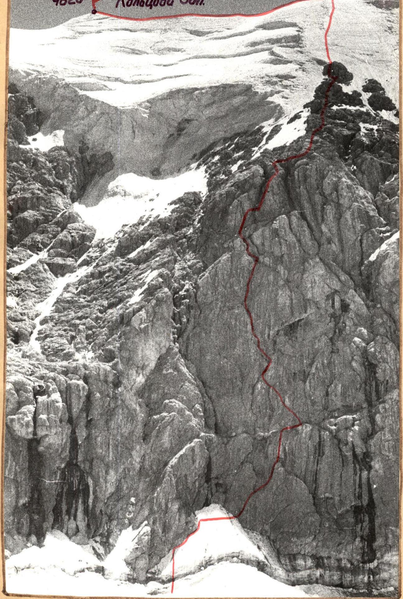
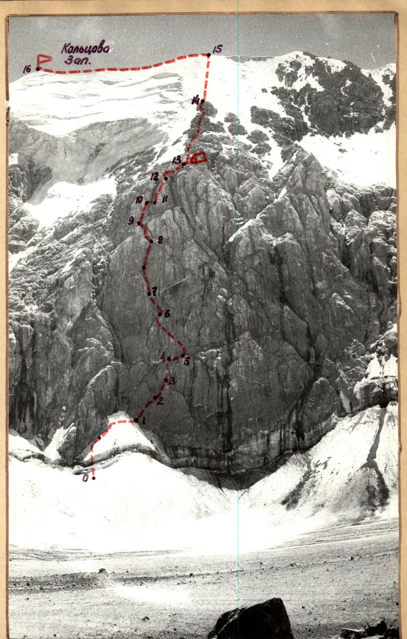 Table of main characteristics of the route to Koltsova West peak via the North wall 5B category.
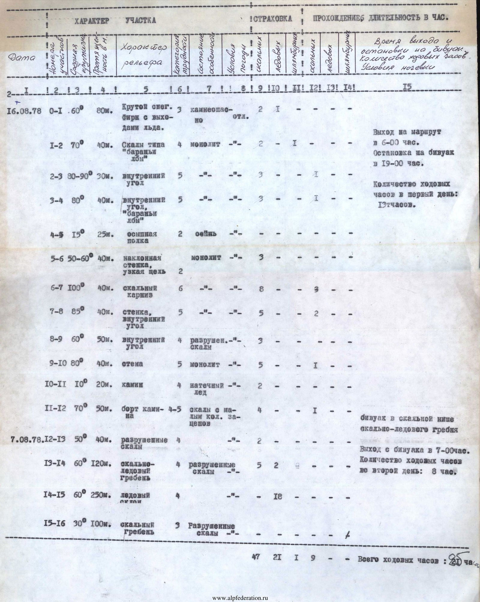
Explanations for the table
R0–R1. The route begins with a steep snowy slope under the left pronounced couloir of the wall. Rockfall hazard! It is belayed depending on the condition, traversed in the left or right part under the cover of the wall (40 m up under the wall rocks, then 40 m traverse of the snowy cone towards a narrow gap).
R1–R2. 40 m up to the right along the inclined gap — exit to a ledge. R2–R3. Up through the inner corner, slightly overhanging in the upper part, — exit to a small wall (10 m) and through it to a block, under the second inner corner. 30 m. R3–R4. Up to the right through the inner corner onto "ram's forehead" type rocks and along them to a debris-filled ledge, horizontally crossing the wall. 40 m.
R4–R5. Along the ledge up to the right under a rock "trough" in the right part of the wall. 20 m. R5–R6. Through medium-difficulty rocks up to the left (40 m), then straight up through an inclined gap towards a rock cornice, cut by a narrow cleft. 50–60 m. R6–R7. The rock cornice is overcome through a narrow cleft (I.T.O.). A variant to the left through a block (I.T.O.) is possible. 40 m. Exit onto a slab. R7–R8. Up the slab (I.T.O.), ascent to the inner corner (40 m) and through it — exit to a wide and short debris-filled ledge (40 m). R8–R9. From the debris-filled ledge through the inner corner up to the left, then slightly to the right — exit to a large rock "blade" at the base of the chimney. 50 m.
R9–R10. Up the left outer corner of the chimney (small wall, block, small wall) under a rock overhang. Difficult climbing. 40 m.
R10–R11. Through a block under the overhang to the right, then along a ledge — entry into the chimney and exit to its right part. The chimney contains consolidated snow. 20 m.
R11–R12. Up the right part of the chimney, then through "ram's forehead" type rocks — to its top. 50 m. Difficult climbing.
R12–R13. Through steep, heavily broken rocks up to the right — onto an icy ridge with rock outcrops. 40 m. Overnight stay in a rock niche on the ridge.
R13–R14. Up the ice-rock ridge — exit under an icy ascent. 120 m.
R14–R15. Up a steep icy (50–60°) slope — ascent to the shoulder of Koltsova West peak. Descent (6 ropes — 250 m).
R15–R16. From the shoulder to the left 50 m to a saddle and from it 50 m through broken rocks — ascent to Koltsova West peak. Descent from the peak to the saddle and from it through a debris-filled couloir onto Kenizdykty glacier.
Before departing on the route, the group conducted preliminary processing and hung fixed ropes up to a large debris-filled ledge. (Sections: R1–R2; R2–R3; R3–R4. After passage, the fixed ropes were cut on the snowy cone).
Several possible bivouacs:
- wide debris-filled ledge (section R4–R5)
- short debris-filled ledge (point 8)
- snow-ice ridge.