ASCENT DOCUMENT
- Ascent class: technical
- Ascent area: Pamir-Alay, Alay Ridge No. 5.5.I KTMGV
- Peak, its height, and ascent route: Peak 5205 via the southeast ridge
- Proposed difficulty category: 4A category of complexity (“Dostuk”)
- Route description: height difference 600 m, average slope 50°. Length of sections: I — 100 m, II — 150 m, IV — 550 m.
- Pitons driven: for belay: rock — 18, ice — —, bolted — —; for creating belay stations: — —.
- Number of climbing hours: 12 hours.
- Number of nights and their description: 1 night at a col ~4600 m.
- Surname, name, patronymic of the leader and participants and their sports qualification:
- MANDRIKO MATI LEOVICH — 2nd sports category — “Kalev” DSO — leader.
- NAUMOV BORIS EFIMOVICH — 1st sports category — participant.
- SHPINYOV IGOR NIKOLAEVICH — 2nd sports category — participant.
- KOLOBOV VLADIMIR ALEKSEEVICH — 2nd sports category — participant.
- Team coach: Naumov B. E.
- Date of departure and return: from July 23, 1977, at 15:00 to July 24, 1977, at 18:00.
PROPOSED NAME — “Dostuk” (“Druzhba”)
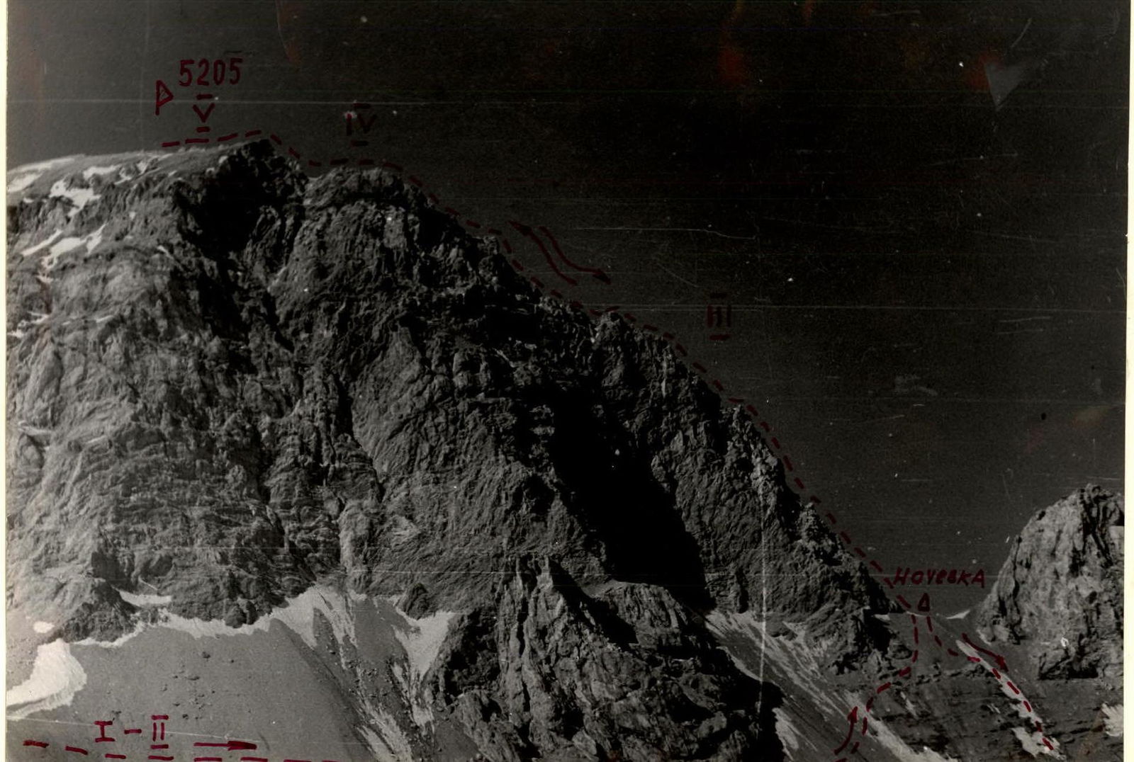
5205
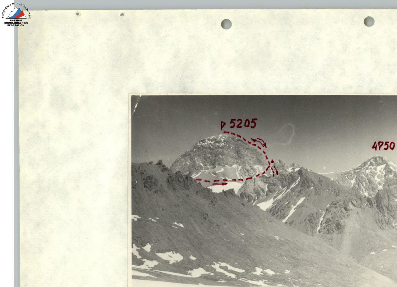
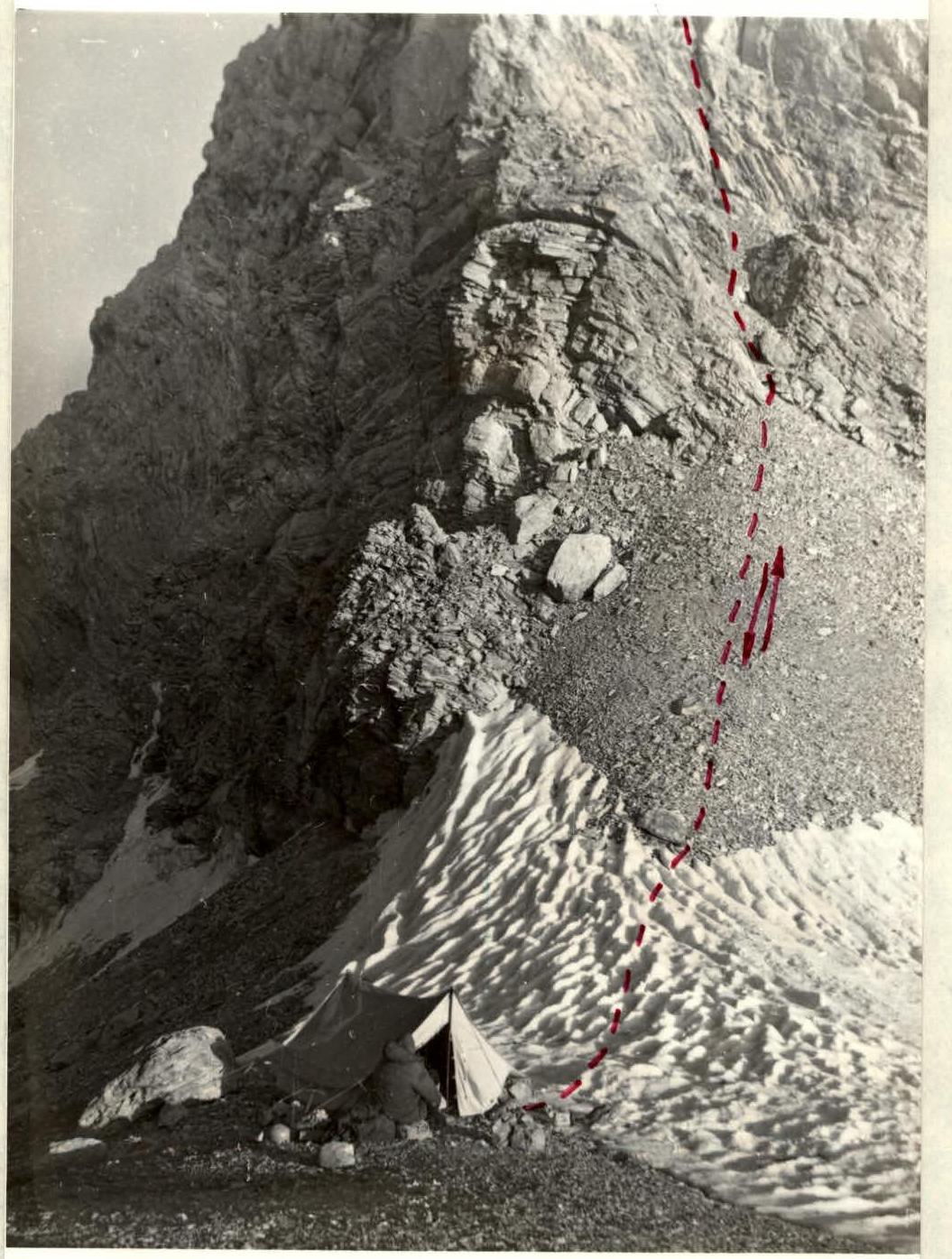
Panorama of Peak 5205
Photo 2
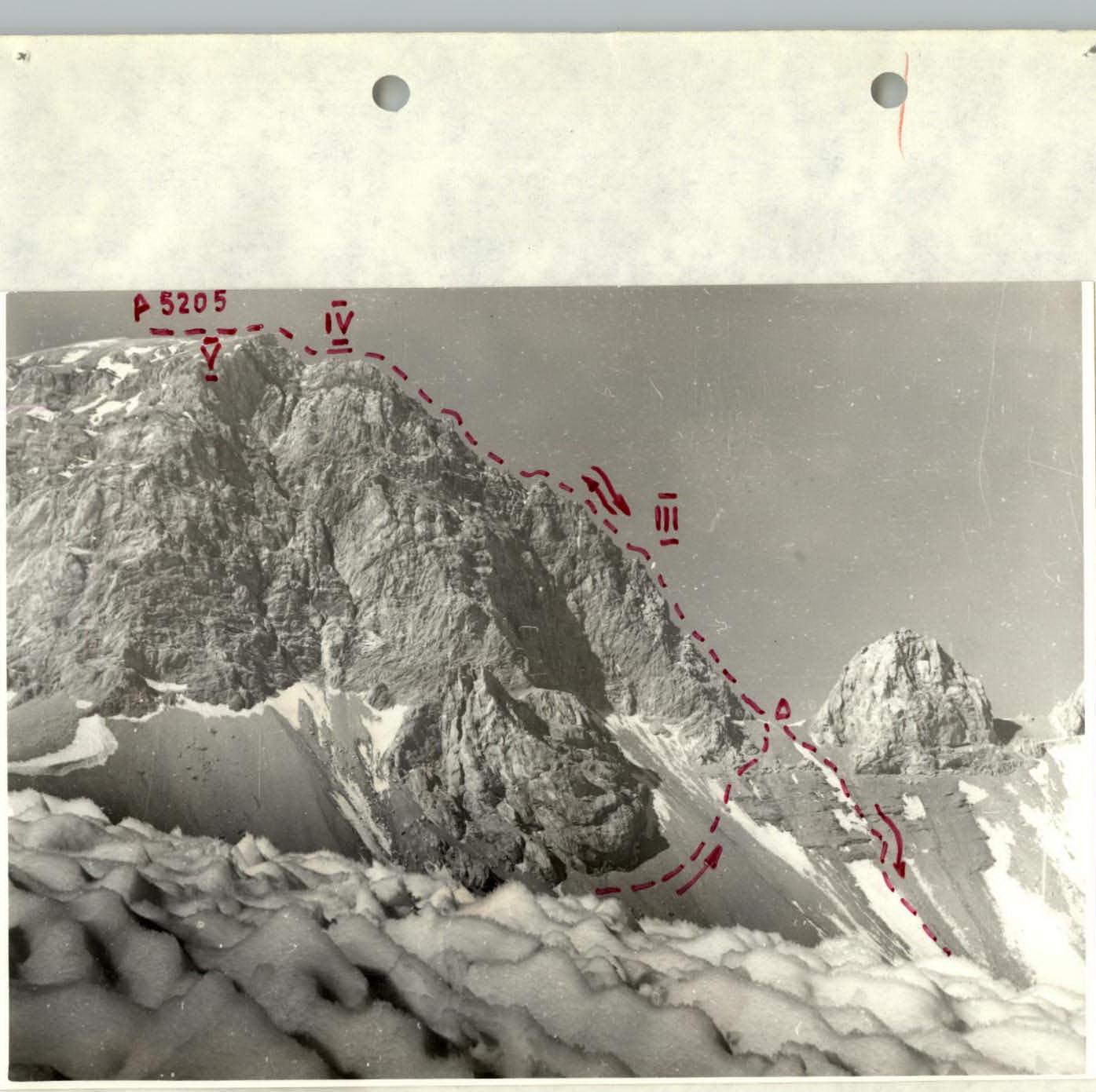
Profile shot of Peak 5205

REPORT on the ascent of Peak 5205 via the southeast ridge, preliminarily assessed as 4A category of complexity.
Section I–II
- We leave the camp on the Allaudin glacier at 15:00 on July 23, 1977. Ascent via scree along the left bank of the stream flowing through the camp, leaving the brown cliffs to the right. After passing the brown cliffs, we ascend to the scree continuation of these cliffs. Then along the ridge to the right in the direction of Peak 5205, we reach the scree slope under Peak 5205, traversing which we reach the scree col between Peak 5205 and a large red gendarme (~4600 m). We set up a night camp here. The path from the camp on the Allaudin glacier to the night camp takes 5 hours.
Section III
- At 7:00 on July 24, 1977, we began the ascent to Peak 5205 via the southeast ridge. The ascent goes through jagged rocks with climbing alternating with ascents through couloirs and walls (5–20 m). The average slope of the ascent is 50–60°. Ascent — 15 ropes (40 m each), many loose rocks. Piton belay — 13 rock pitons.
Section IV
- Ascent on steep scree and worn smooth rocks (150 m). The average slope of the section is 35–40°. Simultaneous belay.
Section V
- Exit to the pre-summit gentle (15–20°) snow dome. Along the dome, 100 m to Peak 5205. Caution: snow cornices on the ridge face north.
We reached the summit at 11:00 on July 24, 1977. Number of climbing hours — 4 hours.
Descent from the summit via the ascent route using the sport descent method. We left three rock pitons with loops. Descent to the scree col took 3 hours. From the col, we descended down the even scree and snow field to the glacier under the peak. By passing the glacier on the left, we reach the scree slope under the brown cliffs. We traverse the scree slope to the right, leaving the brown cliffs to the right, and return to the camp on the Allaudin glacier by 13:00.
For subsequent ascents to Peak 5205 via the southeast ridge, we do not recommend the path we took to the night camp on the col (section R0–R2), but recommend the ascent via the path of our descent from the col.
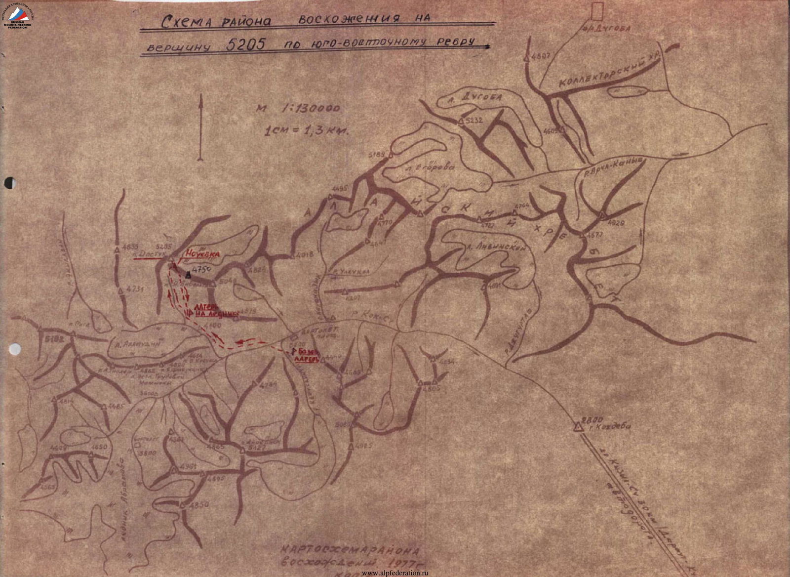
ASCENT AREA MAP
PEAK 5205 VIA SOUTHEAST RIDGE
M 1:130 000 1 cm = 1.3 km.
TABLE of sections of the ascent to Peak 5205 via the southeast ridge
| Date | Designation | Average slope (degrees) | Length (m) | Character of difficulty (terrain) | Condition | Weather conditions | Pitons (rock / ice / bolted) |
|---|---|---|---|---|---|---|---|
| July 24, 1977, 7:00 | II–III | 55° | 550 | Couloirs, walls | Monolith, rocks with “live stones” | Strong wind, snow | 13 / — / — |
| July 24, 1977 | III–IV | 30° | 150 | Couloirs | Scree, worn rocks | — | — / — / Simultaneous movement |
| July 24, 1977, 11:00 | IV–V | 15° | 100 | Firn field | Firn | — | — / — / Simultaneous movement |
Note:
- On the route, on April 24, 1977, we departed from the night camp lightly packed; there is space on the col for several tents.
- Section II–III — continuous ascent with climbing through couloirs and walls (5–20 m) up to 65° slope.
EQUIPMENT
| No. | Equipment, clothing, footwear name | Quantity | Approximately on sections according to Appendix 2, Table 4 | Total weight (kg) |
|---|---|---|---|---|
| 1. | Tricouni or Vibram | 4 | everywhere | 8.0 |
| 2. | Main rope | 2 | everywhere | 5.0 |
| 3. | Rock pitons | 18 | III | 1.8 |
| 4. | Rock hammer | 2 | III | 1.0 |
| 5. | “Pamirka” tent | 1 | II | 3.0 |
| 6. | Primus stove with gasoline | 2 | II | 4.0 |
| 7. | Down jackets | 4 | II | 6.0 |
| 9. | Sleeping bags | 4 | II | 8.0 |
| 10. | Carabiners | 14 | III | 2.1 |