Ascent Passport
I. ASCENT CLASSIFICATION — technical, first ascent.
-
ASCENT AREA, RIDGE — southern spurs of the Alay Ridge.
-
PEAK, ITS HEIGHT, ASCENT ROUTE — Aydarbek, 5127 m, via the NE wall.
-
PROPOSED DIFFICULTY CATEGORY — 5B cat. diff.
-
ROUTE CHARACTERISTICS: height difference 1100 m, length of 5 cat. diff. sections — 590 m, average steepness — 60 °.
-
PITS DRIVEN:
- rock: for belaying — 54, for creating FTO — 1
- ice: for belaying — 29, for creating FTO — 4
- bolt: for belaying — (none), for creating FTO — 4
-
NUMBER OF CLIMBING HOURS — 27.
-
NUMBER OF NIGHTS, THEIR CHARACTERISTICS — 2 (semi-reclining, reclining).
-
LAST NAME, FIRST NAME, PATRONYMIC NAME OF THE LEADER, PARTICIPANTS, AND THEIR QUALIFICATION:
- DMITRIEV A.P. — 1st sports category.
- SHAGINYAN I.E. — Candidate Master of Sports.
-
TEAM COACH — Naumov A.F.
-
DATE OF DEPARTURE ON THE ROUTE AND RETURN — August 16–20, 1978.

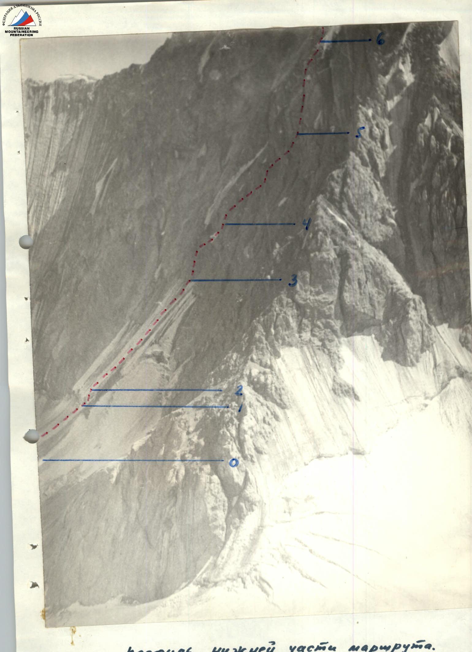 Profile of the lower part of the route.
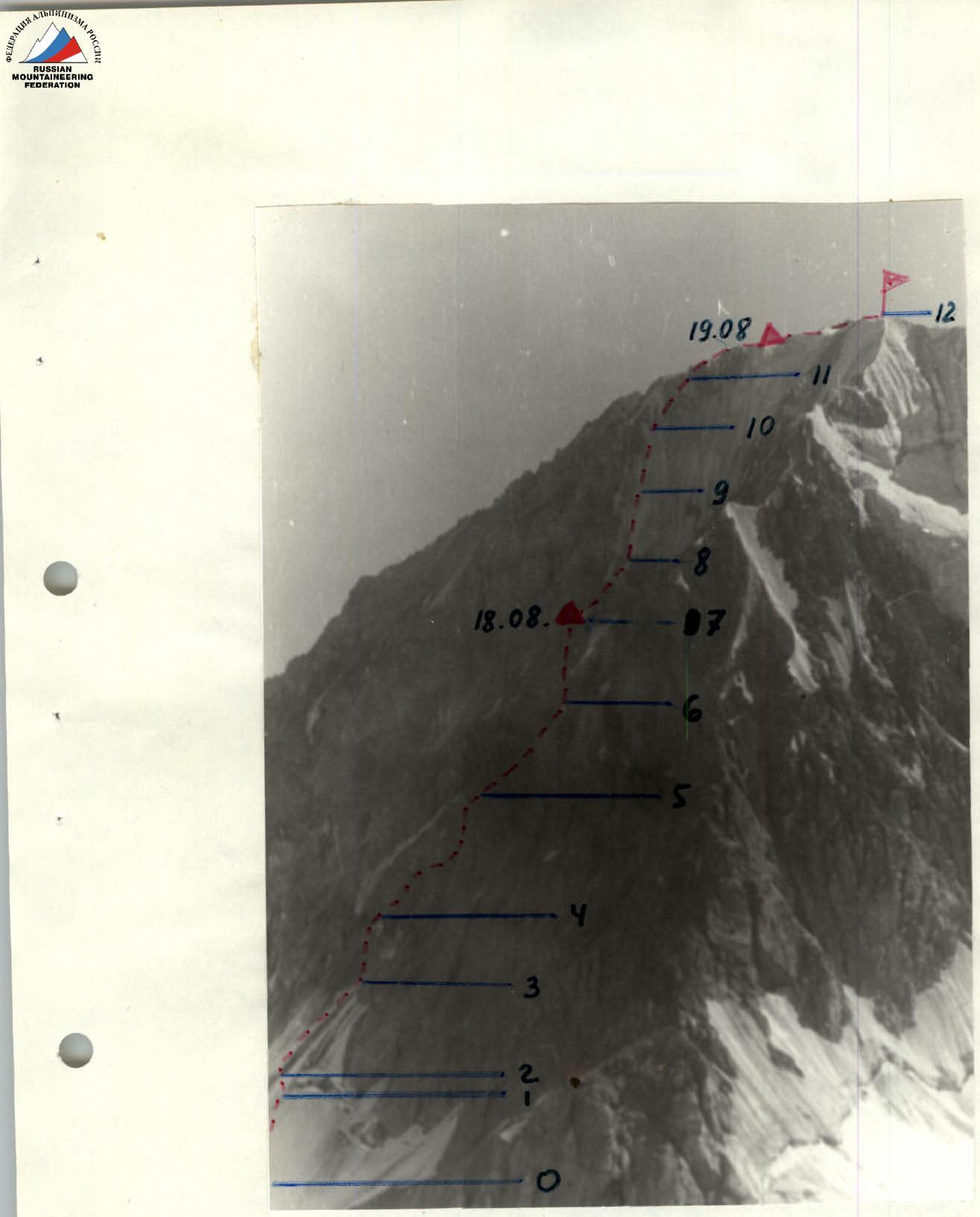 Profile of the route.
Characteristics of the Kok-Su Area
The Kok-Su valley is located in the southeastern part of the Pamir-Alay mountain system. The upper part of the valley, which is of interest in terms of alpinism, is bounded to the north by the Alay Ridge and to the south by one of its spurs, which separates the valleys of the Kok-Su and Tekelik rivers.
The Kok-Su River originates from under the Abramov Glacier. In the area of the Abramov Glacier, there is a stationary glaciological base of the Academy of Sciences of the UzSSR. In the hanging valleys located to the left of the Kok-Su River, the largest glaciers are located: Konigur Glacier, Alaul Glacier, Kara-Kazyk Glacier, and Levinskaya Glacier.
Of the glaciers located to the right of the Kok-Su River, the largest is the Kemizdyкты Glacier. There are quite large glaciers in the areas of the Aydarbek and Tekelik peaks. The area is dominated by peaks with heights ranging from 4700 m to 5200 m. The highest point in the area has a height of 5205 m.
The slopes of the mountains with a predominantly southern orientation are heavily destroyed, are relatively gentle, and, as a rule, do not have a snow-ice cover in their upper part throughout the entire summer season. The slopes oriented to the north and northeast are less destroyed and have a significant steepness.
On the northern slopes in the upper part, rocks prevail, flooded with flow ice. The northern slopes have significant snow cover at the beginning of the summer season.
The peaks of the highest mountains in the area are crowned with ice domes with a characteristic ice structure. The ice on the summit domes is dense, brittle, and when chopping steps, it breaks off in large lenses.
The climate in the Kok-Su area is continental. Summer is hot, with little precipitation.
The area is dominated by meadow and steppe vegetation. Along the banks of the river and streams, juniper grows abundantly, and birch, sea buckthorn, and rowan are found.
The routes to the peaks in the Kok-Su area are diverse, but rock-ice and rock routes prevail.
Until 1977, ascents in the Kok-Su valley were random — ascents to Peak 50th Anniversary of Uzbekistan, Peak Pravda Vostoka of 5B category of difficulty, and others.
In the 1977–1978 seasons, groups of climbers from the Alay mountaineering camp made more than a hundred first ascents, including a number of interesting and complex routes.
General Characteristics of Aydarbek Peak
Aydarbek Peak (5127 m) is located in the area of the southern spurs of the Alay Ridge and is a nodal point. The lateral spurs extending from the node are oriented to the east and west and, as they descend, bend to the north and descend to the Kok-Su River valley.
Aydarbek Peak closes the cirque with the eponymous glacier and peaks: Peak Kommuny (5027 m), Peak Nikitina (4824 m), Peak Skalny (4824 m).
Towards its glacier, Aydarbek faces the northern wall, along which several routes have already been laid, including two of 5B category of difficulty.
The first ascent to this peak was made in 1977 by a group of Voronezh gatherings led by Zaev E.F.
Approaches to the Route
From the base camp on the Kozhdeba meadow, along the left (orographic) bank of the Kok-Su River to the blockage, which is located between the confluences of the Alaudin and Kemizdyкты rivers. Cross to the right bank of the Kok-Su River via the blockage and return to the beginning of the Aydarbek valley, to the confluence of the Kemizdyкты and Aydarbek rivers, and ascend along the right (by course) side of the valley to the Aydarbek cirque.
A bivouac can be organized on the median moraine of the Aydarbek Glacier or on the lateral moraine.
From the base camp to the blockage — 8–9 hours, from the blockage to the median moraine of the Aydarbek Glacier — 3 hours.
Route Description
(Brief explanation of the table of main route characteristics)
On August 16, the group observed the wall, determined the degree of rockfall hazard of the planned route, and clarified the tactics for passing individual sections of the route. On August 17, the group processed the lower part of the wall and the bergschrund. On August 18, the group started the route at 4:00 a.m. to pass the snow-ice slope and bergschrund before sunrise, as this section of the route is partially affected by rockfall during the daytime, as established during observation and processing. The route begins with a snow-ice slope (R0–R1) with a steepness of 30° and a length of ~250 m, which leads to the bergschrund (R1–R2). The ice wall of the bergschrund is passed using artificial points of support. After the bergschrund, there is a snow-ice slope (R2–R3). The ascent along it is directly facing, to the left of the ice gully descending from the couloir that bisects the Northeast wall in its right part. The snow-ice slope leads to the rocks of the NE wall at the beginning of the chimney that bisects the lower part of the wall (R3–R4). The chimney is passed with piton belays, climbing is complex. The chimney leads to a ledge. On the ledge, to the left — to a crack, then up the crack ~20 m, steepness ~75°, exit to rocks of the "ram's forehead" type (R4–R5). The rocks are destroyed. The "ram's foreheads" are intersected to the right upwards towards the red bastion. The "ram's foreheads" gradually turn into slab-like smoothed rocks, местами with flow ice (R5–R6). In their upper part, they form an internal angle that leads to a ledge under the red bastion. To the left along the ledge — to the beginning of the chimney that bisects the red bastion (R6–R7). Up the chimney directly, climbing is complex. The first person goes without a backpack. The chimney leads to the destroyed upper part of the red bastion. Here, a bivouac can be organized (first night). From the bivouac, directly up the ice slope with inclusions of rocks (R7–R8). The ice is very dense, crampons hold poorly, and steps need to be chopped. Sections R8–R9 and R9–R10 are passed with piton belays, adhering to the boundary of ice and rocks in the direction of the main ridge of the peak. In the area of a large black stone protruding from the ice, move to the left onto steep but heavily destroyed rocks (R10–R11). Movement is complicated by the presence of flow ice on the rocks. Before exiting onto the eastern ridge of the peak — a vertical wall ~20 m, very destroyed. Up the wall — to the eastern ridge. The ridge is not complex. A good bivouac can be organized on the ridge (second night). Along the ridge to the saddle connecting the Eastern ridge with the peak. The main summit of Aydarbek is approximately 100 m south of the E. ridge. Descent from the peak to the west via a route of 3B category of difficulty. The route passed is assessed by the group as 5B category of difficulty.
Participants:
- Dmitriev A.I.
- Shaginyan I.E.
ROUTE TABLE. Appendix 2.
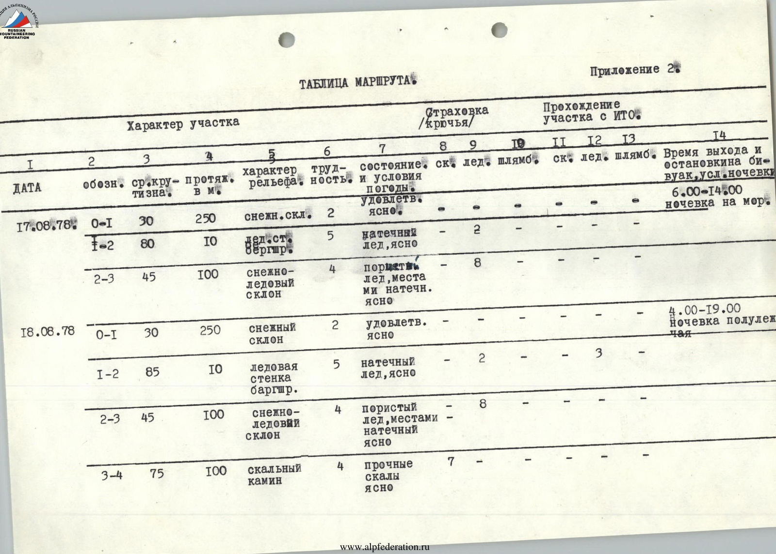

| Date | Section | Steepness, ° | Length, m | Relief | Difficulty, cat. diff. | Weather, condition | Rock pits (belay) | Ice pits (belay) | Bolt pits (belay) | Rock pits (FTO) | Ice pits (FTO) | Bolt pits (FTO) | Time/Bivouac |
|---|---|---|---|---|---|---|---|---|---|---|---|---|---|
| August 17, 1978 | R0–R1 | 30 | 250 | Snow slope | 2 | Satisfactory, clear | – | – | – | – | – | – | 6:00–14:00, overnight on moraine |
| R1–R2 | 80 | 10 | Bergschrund | 5 | Flow ice, clear | 2 | – | – | – | – | – | – | |
| R2–R3 | 45 | 100 | Snow-ice slope | 4 | Porous ice, местами flow ice, clear | – | 8 | – | – | – | – | – | |
| August 18, 1978 | R0–R1 | 30 | 250 | Snow slope | 2 | Satisfactory, clear | – | – | – | – | – | – | 4:00–19:00, semi-reclining bivouac |
| R1–R2 | 85 | 10 | Ice wall of bergschrund | 5 | Flow ice, clear | 2 | – | – | 3 | – | – | – | |
| R2–R3 | 45 | 100 | Snow-ice slope | 4 | Porous ice, местами flow ice, clear | – | 8 | – | – | – | – | – | |
| R3–R4 | 75 | 100 | Rock chimney | 4 | Solid rocks, clear | 7 | – | – | – | – | – | – | |
| R4–R5 | 60 | 160 | Destroyed rocks | 3 | Satisfactory | 5 | – | – | – | – | – | – | |
| R5–R6 | 60 | 160 | Smoothed rock slabs | 4 | местами flow ice | 40 | – | – | – | – | – | – | |
| R6–R7 | 80 | 100 | Chimney | 5 | With cork, cloudy, cold | 8 | – | – | – | – | – | – | |
| August 19, 1978 | R7–R8 | 50 | 120 | Ice slope with rock outcrops | 5 | Flow ice | 3 | 6 | – | – | – | – | 8:00–20:00, reclining bivouac on ridge |
| R8–R9 | 50 | 160 | Ice slope with rock outcrops | 5 | Flow ice, cloudy, cold | 6 | 6 | – | 1 | – | – | – | |
| R9–R10 | 55 | 120 | Ice slope | 5 | Flow ice, cloudy, cold | 1 | 5 | – | – | – | – | – | |
| R10–R11 | 70 | 80 | Destroyed rocks | 5 | Flooded with flow ice, cloudy, cold | 6 | – | 1 | – | – | – | – | |
| R11–R12 | 40 | 350 | Ridge, summit | 3 | Ice ascents, walls, cloudy, cold | 8 | 2 | – | – | – | – | – |
August 20, 1978. Descent along the Western Ridge via the Nameless Peak by a route of 3B category of difficulty at 9:00. Return to camp.