Ascent Log
- Ascent classification: technical
- Ascent area: Pamir-Alay, Aidarbek gorge.
- Peak, its height, ascent route: Aidarbek peak, 5127 m, via the North face (Zayev's route)
- Difficulty category: 5B category difficulty.
- Route characteristics: height difference — 1120 m length of 5B category difficulty sections — 202 m average steepness — 58°
- Pitons hammered: for belaying — 74 for creating Intermediate Technical Objects (ITO) — 9 rock pitons — 65 ice pitons — 17 alpine pitons — 1
- Number of climbing hours: 26 hours
- Number of bivouacs and their characteristics: one, lying in a tent
- Surname, name, patronymic of the leader, participants, and their qualification: Smagdykhov Sarsen Yevgenyevich, CMS (Candidate for Master of Sports) Bantiksky Anatoly Ivanovich, CMS Akhtyarsky Oleg Aleksandrovich, MS (Master of Sports)
- Team coach: Akhtyarsky Oleg Aleksandrovich, MS
- Date of departure for the route and return: August 13, 1978 – August 14, 1978
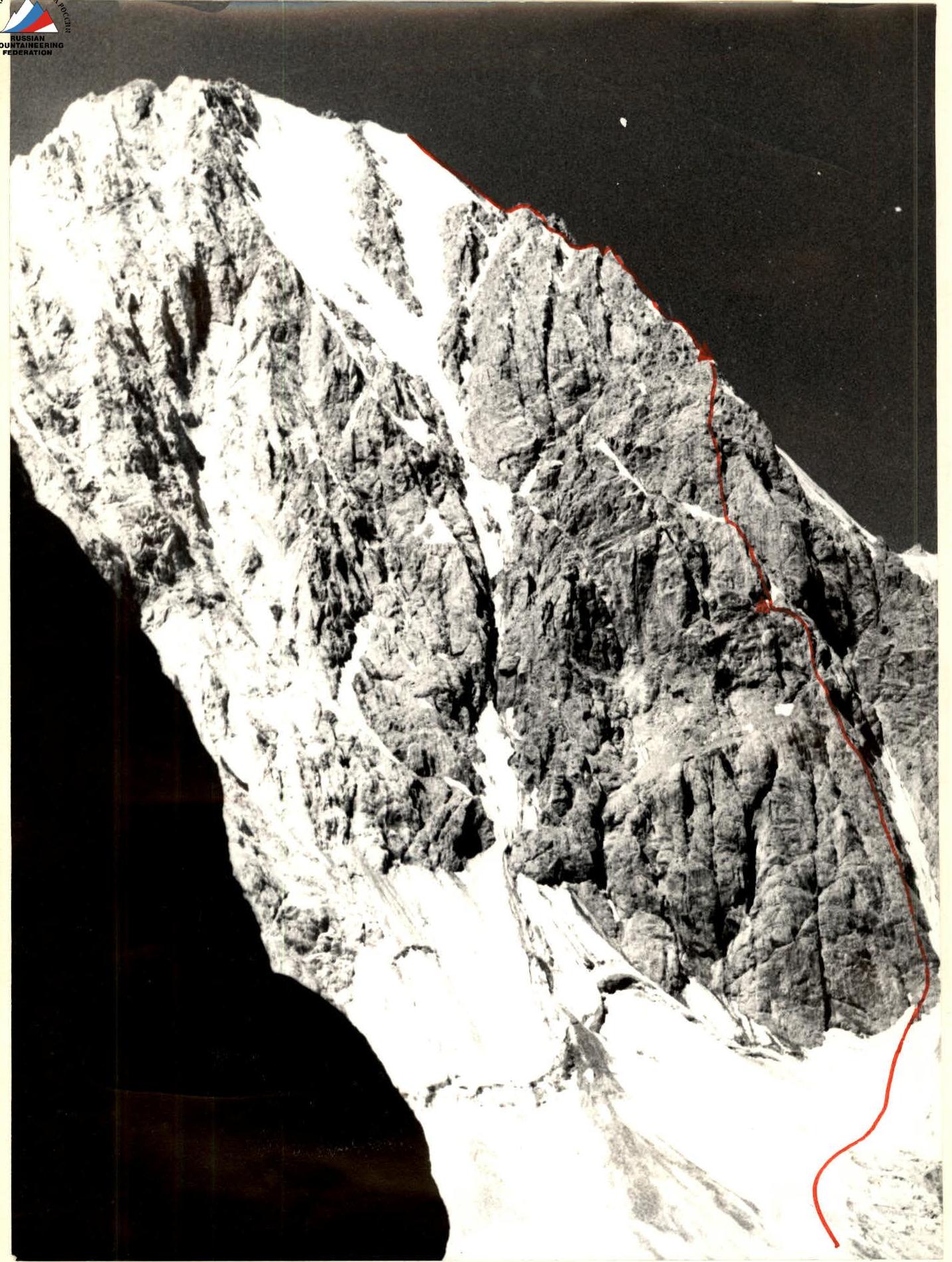
Table of main characteristics of the route to v. Aidarbek (5127 m) via the North face (Zayev's route) 5B category difficulty.
| Date | Section number | Character | Average steepness, ° | Length, m | Relief | Condition | Weather conditions | Belaying | Passage, length | Time of departure and stop | |-------------------|-----------|-----------|---------------------|-----------|-------------|------------------|----------------|--------------------------------------------------|------------------|----------|-----------------------------| | | | | | | | | | Rock pitons | Ice pitons | Buries | Rocks | Ice | Yamburs | Passing, climbing hours | Bivouac conditions | | August 13, 1978 | R0–R1 | Snow-ice slope | 30 | 200 | 2 | Falling rocks | clear | on crampons | one | | | | | 6:00–19:00 | | | | R1–R2 | Wall | 75 | 80 | 5 | Monolith | " | " | 7 | ledges | | | | 13 hours 00 min | | | | R2–R3 | Counterfort | 50 | 160 | 4 | Destroyed rocks | " | " | 8 | " | | | | | | | | R3–R4 | Slab | 80 | 40 | 5 | Monolith | " | " | 5 | | | | | | | | | R4–R5 | Cornice | 95 | 10 | 6 | Destroyed rocks | " | " | 3 | | | 1 | | | | | | R5–R6 | Oblique shaft | 60 | 40 | 4 | The same | " | " | 2 | chocks | | | | | | | | R6–R7 | Slab | 80 | 80 | 5 | Ice accretion | " | " | 4 | | 2 | | | | | | | R7–R8 | Wall | 90 | 10 | 5 | Destroyed rocks | " | " | 2 | | | | | | | | | R8–R9 | Shelf | 30 | 30 | | Falling rocks | " | " | | ledges | | | | | | | | R9–R10 | Wall | 80 | 50 | 5 | Slab-like rocks | " | " | 6 | | | | | | | | | R10–R11 | Wall | 90 | 10 | 5 | With a gap | " | " | 8 | | 1 | | | | | | | R11–R12 | Shelf | 30 | 40 | | Filled with ice | " | " | 2 | | | | | | | | | R12–R13 | Wall | 70 | 60 | 4 | Block structure | " | " | 6 | | | | | | | | | R13–R14 | Rocky ridge | 80 | 200 | 4 | Destroyed rocks | " | " | 11 | ledges | | | | | lying in a tent | | August 14, 1978 | R14–R15 | Ice ridge | 10 | 40 | 2 | Sharp | " | " | 1 | | | | | 7:00–21:00 | | | | R15–R16 | Rocky wall | 50 | 100 | 5 | Ice sections | " | " | 7 | | 3 | | | 14 hours | | | | R16–R17 | Ice wall | 80 | 15 | 5 | Ice accretion | " | " | 2 | | | 3 | | | | | | R17–R18 | Rocky ridge | 60 | 90 | 4 | Destroyed | " | " | 4 | ledges | | | | | | | | R18–R19 | Ice ridge | 60 | 80 | 4 | Rock outcrops | " | " | 2 | | 3 | | | | | | | R19–R20 | Ice ridge | 45 | 120 | 4 | Ice accretion | " | " | 9 | | | | | | | | | R20–R21 | Rocky ridge | 10 | 200 | 2 | Destroyed | " | simultaneously, ledges | | | | | | | |


Explanations for the table
The ascent is made with a bivouac on the right moraine of the Aidarbek glacier.
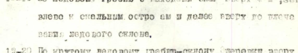
R0–R1. Snow-ice slope 30°, 200 m under the North face of the peak. R1–R2. Rocky wall 75°, 80 m at the base of the North face. R2–R3. Rocks of medium difficulty along a clearly defined rib of the counterfort, about 4 ropes. R3–R4. Smooth monolithic slab under an overhang. R4–R5. From the slab to the left and along a narrow gap through the cornice to a shelf. R5–R6. From the shelf upwards to the right 40 m along an oblique gap to a slab-like wall. R6–R7. Along the slab with ice accretion to a short vertical destroyed wall (30 m). R7–R8. Along the destroyed wall, traverse to the left with an exit to a scree shelf. R8–R9. Along the shelf to the left under a 60 m slab-like wall. Control tour in a can, not an ice screw. R9–R10. From here upwards along the slab-like rocks of the wall 50 m along a narrow ledge. R10–R11. From the ledge upwards along a narrow gap in the sheer wall 10 m. R11–R12. Further along the ice-filled shelf, traverse to the left 40 m. R12–R13. Along rocks of block structure to the right upwards two ropes. R13–R14. And along the destroyed rocky ridge, ascent to the North ridge (15 ropes). Under the horizontal snow bridge — a platform for bivouacs. R14–R15. Along the sharp ice ridge under the rocky ascent of the ridge. R15–R16. Along the ice-filled rocks straight up, bypassing the summit ascent to the left. R16–R17. 15 m ice wall of the gendarme is passed head-on with an exit to the right on the saddle. R17–R18. From the saddle 2 ropes along a highly destroyed, with ice sections, ridge. R18–R19. Along the ice ridge with an exit of snow upwards 4 m, then traverse to the left and along rocky "islands" and further upwards along the shoulder 40 m at the base of the ice slope. R19–R20. Along the steep ice ridge-slope (2 ropes) upwards to the pre-summit ridge. R20–R21. Along the destroyed rocks of the ridge simultaneously (5 ropes) ascent to the summit.
Descent via the 5B category difficulty route through v. Bezymanaya.