Ascent Log
I. Ascent category — technical
II. Ascent area — Pamir-Alai, Alai ridge, "Dugoba" river basin
-
"Bezymyannaya" peak, 4482 m, West counterfort of the North-East ridge, combined route.
-
Proposed category of difficulty — 3B
-
Route characteristics:
- height difference — 940 m;
- for participants of the 5th category of difficulty — 20 m;
- average steepness 45°.
- Pitons hammered:
| Rock | Ice | |
|---|---|---|
| for belay | 24 | 6 |
| for creating artificial points of support | 0 | 8 |
No drill-in pitons or placed protection were used.
-
Number of climbing hours — 19 hours.
-
Number of bivouacs and their characteristics:
- one bivouac in a snow depression behind the summit towards the descent, convenient, in an open snow cave.
- Ascent participants:
- Pakolo Valery Matveevich — Master of Sports of the USSR — leader
- Zubenko Anatoly Timofeevich — 1st sports category — participant
- Bakanov Vladimir Anatolyevich — —
- Yakovlev Nikolai Petrovich — —
-
Team coach — Bocharov Vladimir Nikolaevich.
-
Date of departure on the route — August 29, 1986
Return — August 30, 1986
- Organization: "Dugoba" mountaineering base.
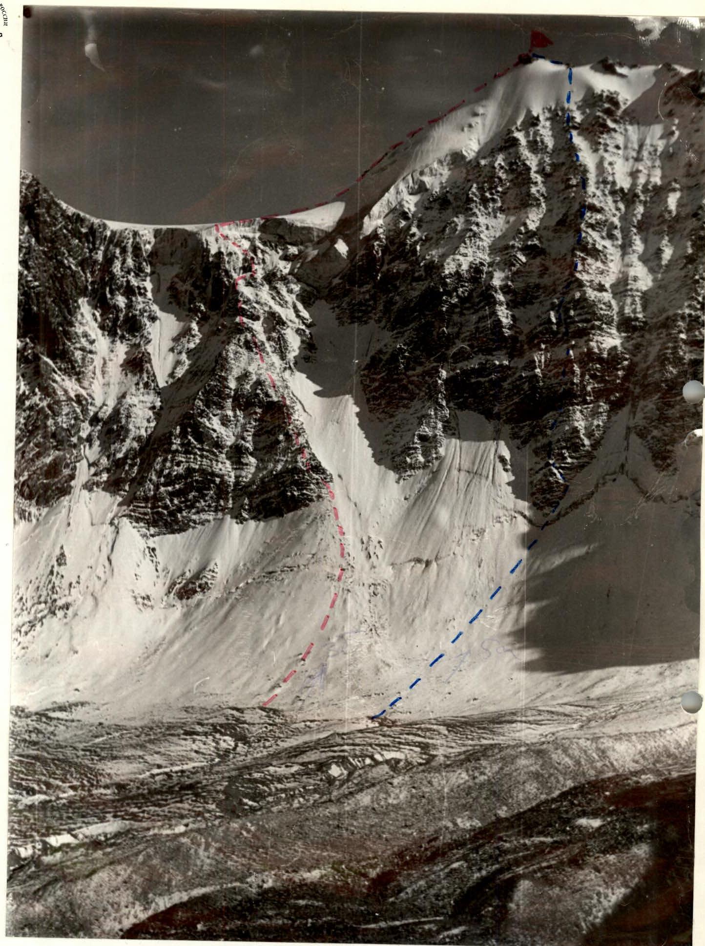
Photo of the summit with the group's route (red line) and the first ascent route via the Central counterfort of the North-West wall on July 1, 1986 (leader Borisov B.V.) (blue line).
"Bezymyannaya" peak is located in the Alai (Kollektorsky) ridge between "Yubileynaya" peak and "Pioner" peak. From the north and north-east, it is bounded by steep snow-covered and glaciated slopes into the "Ulitor" valley towards the "Ulitor" glacier moraine. To the south, gentle slopes descend into the "Trum" valley. Previously, there were individual non-classified ascents to the summit via the ridges from:
- "Yubileynaya" peak;
- "Pioner" peak.
In 1986, two first ascents were made to "Bezymyannaya" peak by groups of instructors from AUSB "DUGOVA":
- on July 2, 1986 — via the central counterfort of the North-West wall, approximately 5A category of difficulty.
- The ascent described in this report.
In both cases, the descent was made towards "Pioner" peak: first along the South-West ridge, through "Pioner" peak, then along the North-West slope of "Pioner" peak, and further to the initial bivouac.
The volume of work and weather conditions required organizing a bivouac directly behind "Bezymyannaya" peak, towards the descent. According to the first ascenders, the route is relatively safe, presents a certain interest for training ascents as a combined route, and requires good ice climbing skills from the ascenders.
Map of the ascent area.
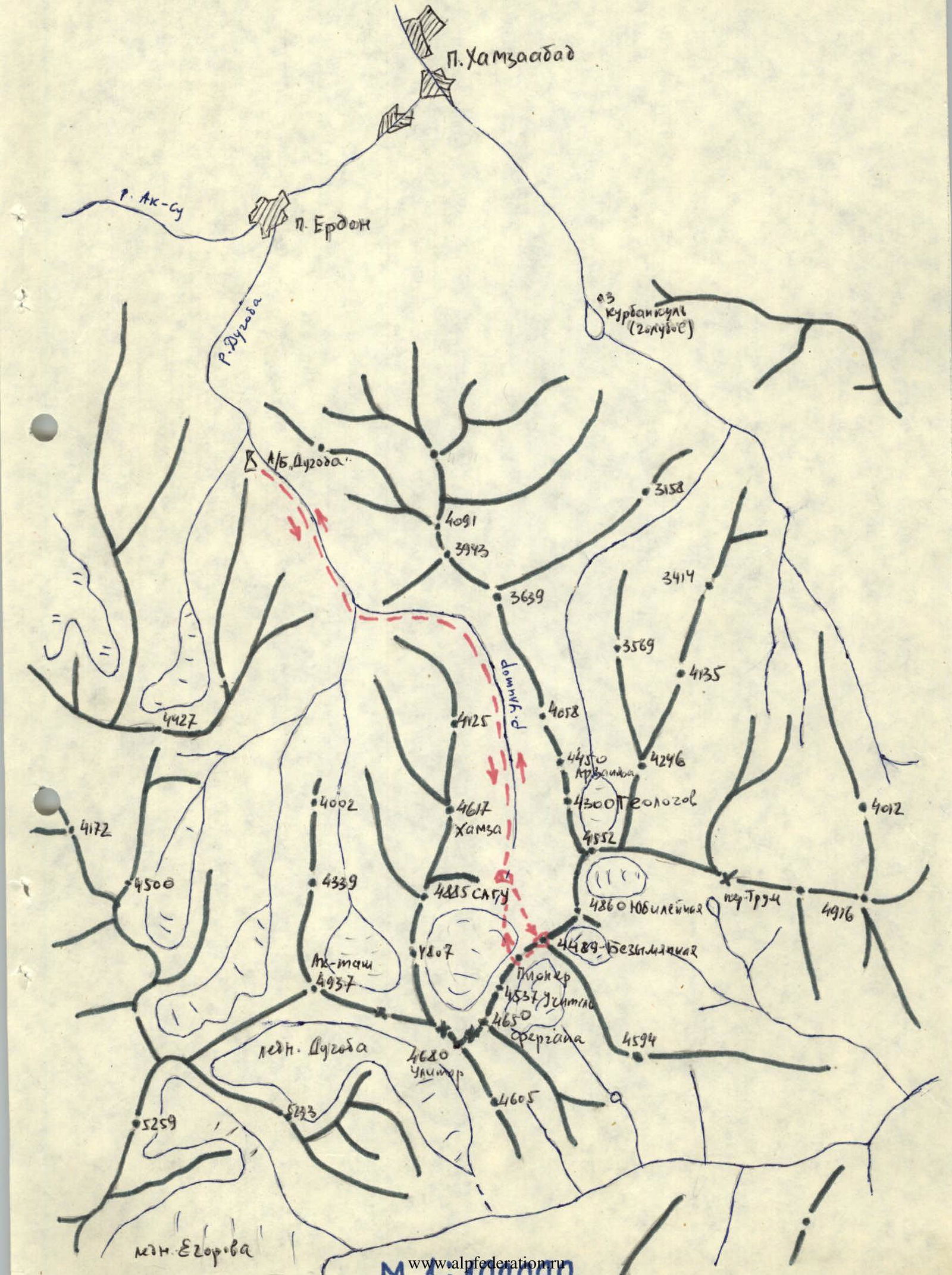
Brief description of the approach to the route
From the "Dugoba" mountaineering base, follow the left orographic side of the "Dugoba" river to the turn into the "Ulitor" valley (to the 1st confluence) — 1.5 hours. Cross the bridge and move along the "Ulitor" valley on the left orographic side of the "Ulitor" river to the "Edelweiss" meadow (1 hour), then up the valley past the peaks:
- Gandakush,
- Geologov,
- Yubileynaya
to the large, closing the entire valley, terminal moraine of the "Ulitor" glacier — 3.5–4 hours. Here, move left under the route to "Bezymyannaya" peak (in the ridge, it is the next one after "Yubileynaya" peak). Bivouac on the moraine opposite the North-West wall of "Bezymyannaya" peak.
The entire approach from AUSB "Dugoba" takes 6–6.5 hours.
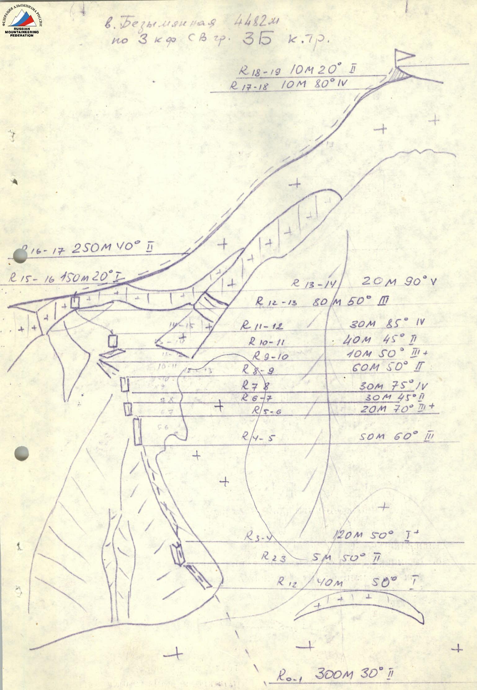
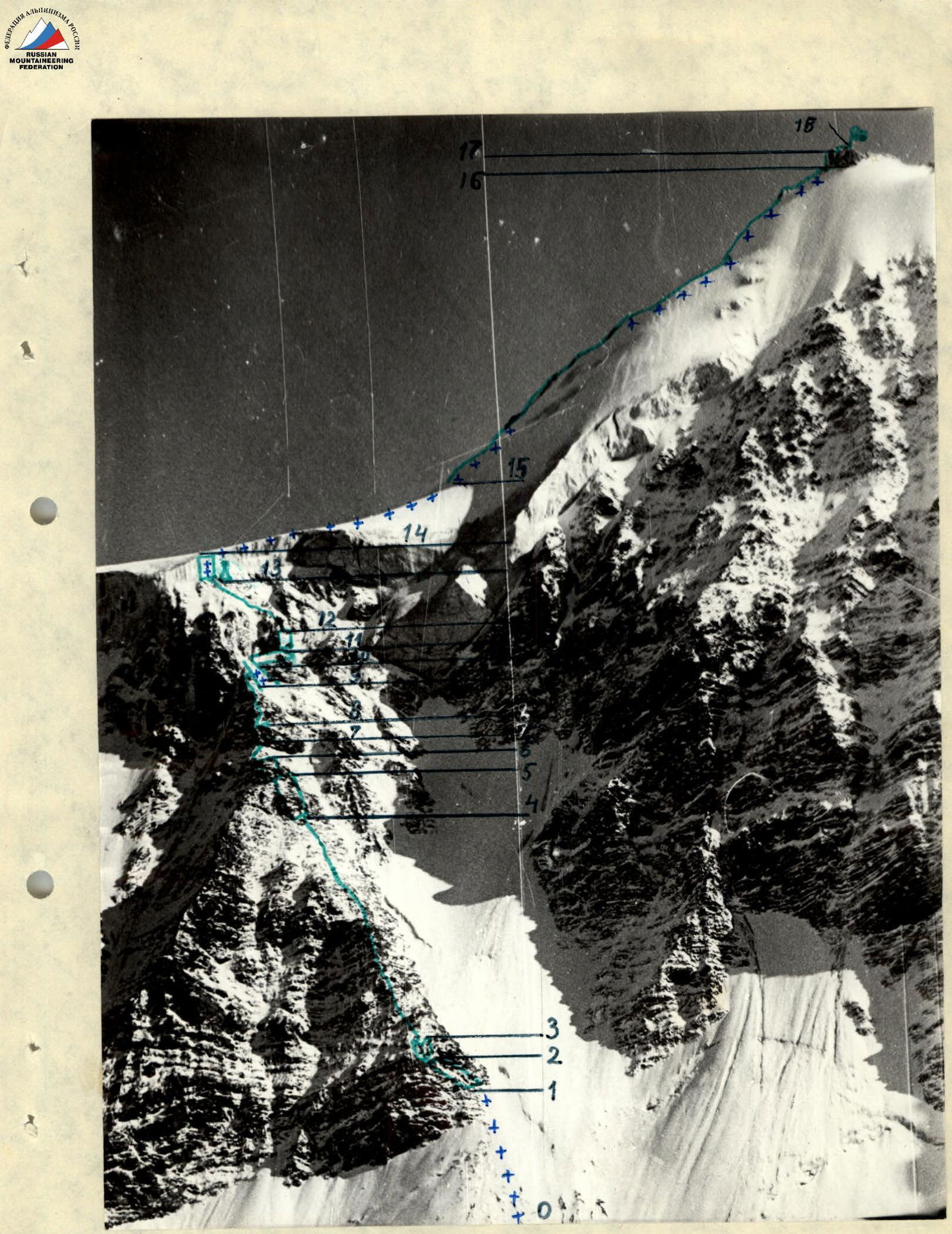
ROUTE SCHEME IN UIAA SYMBOLS
Brief explanation of the route scheme in UIAA symbols

| Section | Terrain character | Length, m | Steepness, ° | Category of difficulty | State of terrain | Climbing technique | Weather conditions | Pitons: rock (belay) | Pitons: ice (belay) | Pitons: rock (aid) | Pitons: ice (aid) |
|---|---|---|---|---|---|---|---|---|---|---|---|
| R0–R1 | ice slope | 300 | 30 | 2 | exposed glacier | simultaneous movement in crampons | clear | 0 | 0 | 0 | 0 |
| R1–R2 | inclined ledge | 40 | 45 | 1 | shattered rocks | simultaneous movement, belay through rock features | — | 0 | 0 | 0 | 0 |
| R2–R3 | inner corner | 5 | 50 | 2 | shattered rocks | simultaneous movement, belay through rock features | — | 0 | 0 | 0 | 0 |
| R3–R4 | rocky ridge | 120 | 50 | 1 | shattered rocks | — | — | 0 | 0 | 0 | 0 |
| R4–R5 | rock wall | 50 | 60 | 3 | monolith, some "live" rocks | alternating movement, belay through rock features and pitons | — | 4 | 0 | 0 | 0 |
| R5–R6 | rock wall | 20 | 70 | 3 | — | — | — | 2 | 0 | 0 | 0 |
| R6–R7 | rocky ridge | 30 | 45 | 2 | shattered rocks | simultaneous movement, belay through rock features | — | 0 | 0 | 0 | 0 |
| R7–R8 | rock wall | 30 | 75 | 4 | monolith, some "live" rocks | alternating movement, piton belay | — | 6 | 0 | 0 | 0 |
| R8–R9 | rocky ridge | 60 | 50 | 2 | snow-covered, shattered | simultaneous movement, belay through rock features | — | 0 | 0 | 0 | 0 |
| R9–R10 | ice gully | 10 | 50 | 3 | snow-covered | alternating movement, belay through rock features and pitons | — | 0 | 1 | 0 | 0 |
| R10–R11 | inclined ledge | 40 | 45 | 2 | scree, snow-covered | simultaneous movement, belay through rock features | clear | 0 | 0 | 0 | 0 |
| R11–R12 | rock wall | 30 | 85 | 4 | monolith, some "live" rocks | alternating movement, piton belay | — | 5 | 0 | 0 | 0 |
| R12–R13 | rocky ridge | 30 | 50 | 3 | snow-covered, shattered | alternating movement, belay through rock features and pitons | — | 4 | 0 | 0 | 0 |
| R13–R14 | ice wall | 20 | 90 | 5 | ice forming, icicles | alternating movement on double rope, etc., ladders, fixed ropes | — | 0 | 5 | 0 | 8 |
| R14–R15 | ice slope | 150 | 20 | 1 | closed glacier | simultaneous movement | fog | 0 | 0 | 0 | 0 |
| R15–R16 | ridge | 250 | 40 | 1 | scree, snow-covered, icy | simultaneous movement in crampons | — | 0 | 0 | 0 | 0 |
| R16–R17 | rock wall | 10 | 80 | 4 | shattered | alternating movement, belay through rock features and pitons | — | 3 | 0 | 0 | 0 |
| R17–R18 | rocky ridge | 10 | 20 | 2 | shattered, snow-covered | alternating movement, belay through rock features | — | 0 | 0 | 0 | 0 |