
Ascent Passport
- Ascent class - technically challenging.
- Ascent area -
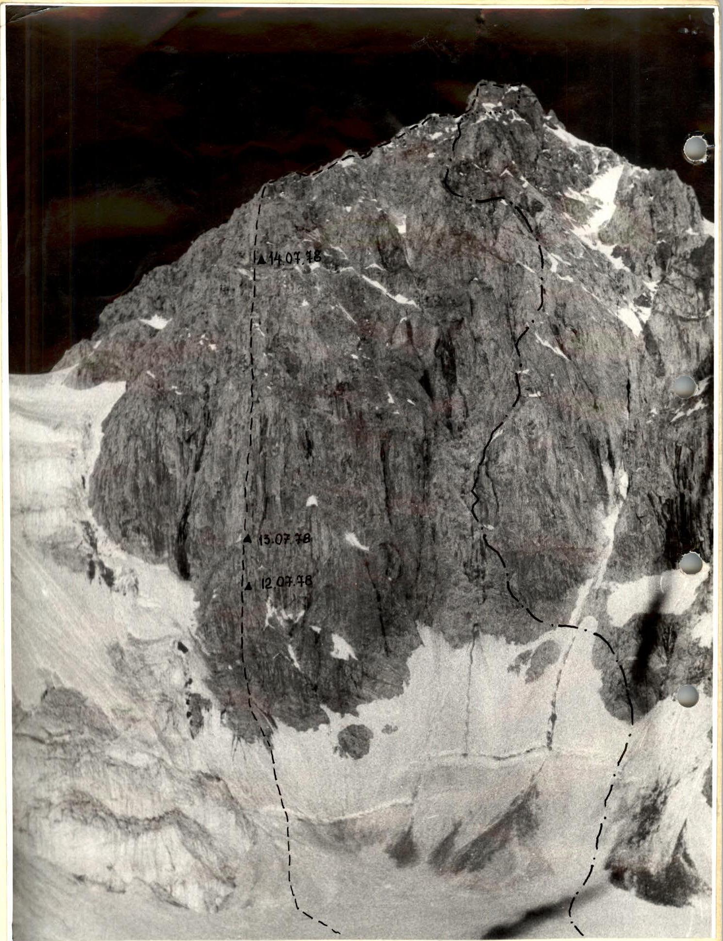
- Peak Uzbekistan 5150 m above sea level via the left bastion of the northeast wall.
- Difficulty category - approximately 5B.
- Route characteristics height difference 935 m average steepness 75° length of sections
| I | II | III | IV | V | VI |
|---|---|---|---|---|---|
| — | — | 50 m | 410 | 200 | 617 |
- Pitons hammered in:
| | for belaying | for aid climbing | | | :-------------------: | :-------------: | :-: | | rock | 139 | 28 | | ice | 2 | — | | bolt | 1 | — | | cams and stoppers | | 21 |
- Number of climbing hours 43.
- Overnight stays on the route 3: 1 sitting, 2 normal.
- Korolev Mikhail Ivanovich, Candidate Master of Sports; Popov Gennadii Yakovlevich, Candidate Master of Sports.
- Team coach - Tyisyachnaya Galina Grigoryevna.
- Departure after two days, observation of the route on July 12, 1978. Return on July 15, 1978 – August 7, 1978
 First ascent route
Route via NE wall, 5B difficulty category.
First ascent route
Route via NE wall, 5B difficulty category.
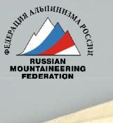 Photo of the summit profile.
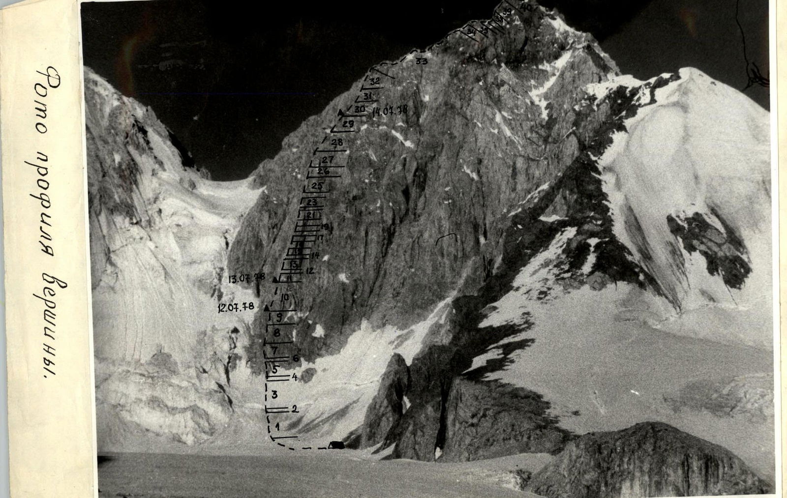 TABLE
TABLE
| Day | Section # | Average steepness | Length | Terrain characteristics | Difficulty | Condition | Weather conditions | Pitons: Rock | Ice | Bolt | Cams |
|---|---|---|---|---|---|---|---|---|---|---|---|
| 12.07.1978 | 1 | 30° | 100 m | Snow slope | 3 | Hard firn | Clear, around 0° | ||||
| 2 | 90° | 2 m | Ice wall | 3 | |||||||
| 3 | 45–55° | 60 m | Ice slope | 4 | 2 | ||||||
| 4 | 90° | 3 m | Wall | 6 | Smooth, no holds | Sunny, above 0° | 3 | ||||
| 5 | 70° | 25 m | Wall | 5 | Heat | 6 | |||||
| 6 | 70° | 15 m | Inner corner | 5 | 3 | ||||||
| 7 | 95° | 2 m | — | 5 | 1 | ||||||
| 8 | 70° | 60 m | Wall | 5 | Wall with good holds | 8 | |||||
| 9 | 70° | 40 m | Chimney | 5 | Covered with small debris | 4 | |||||
| 10 | 90° | 20 m | Chimney | 5 | Left side covered with ice | 2 | |||||
| Departure from bivouac at 6:00, stop for overnight stay at 18:00, 12 climbing hours, sitting bivouac |
| Day | Section # | Average steepness | Length | Terrain characteristics | Difficulty | Condition | Weather conditions | Pitons: Rock | Ice | Bolt | Cams |
|---|---|---|---|---|---|---|---|---|---|---|---|
| 13.07.1978 | 11 | 60° | 40 m | Wall | 5 | 6 | |||||
| 12 | 80° | 30 m | Bastion with a crack | 6 | Completely without holds | Sunny, above 0° | 2 | XI | |||
| 13 | 95° | 1 m | Plug | 6 | Smoothed by erosion | Heat | |||||
| 14 | 80° | 20 m | Wall with one thin crack | 6 | 5 | XII | |||||
| 15 | 95° | 3 m | Block | 6 | 1 | III | |||||
| 16 | 80° | 20 m | Wall | 6 | Small holds | Sunny, above 0° | 5 | V | |||
| 17 | 70° | 20 m | Slab | 6 | — | 1 | 1 | ||||
| 18 | 75° | 15 m | Ledge | 6 | 2 | ||||||
| 19 | 100° | 5 m | Crack with a plug | 6 | 2 | II | III | ||||
| 20 | 80° | 20 m | Wall | 6 | 4 | I | II | ||||
| Departure from bivouac at 7:00, stop for overnight stay at 20:00, 13 climbing hours, bivouac at the start of section 12, 40 m above the previous bivouac |
| Day | Section # | Average steepness | Length | Terrain characteristics | Difficulty | Condition | Weather conditions | Pitons: Rock | Ice | Bolt | Cams |
|---|---|---|---|---|---|---|---|---|---|---|---|
| 14.07.1978 | 21 | 70° | 15 m | Ridge | 6 | Smoothed by erosion | 4 | ||||
| 22 | 90° | 2 m | Wall | 6 | Sunny, above 0° | 1 | 1 | ||||
| 23 | 70° | 40 m | Inner corner | 6 | 8 | ||||||
| 24 | 80° | 8 m | Slab | 6 | 1 | 1 | |||||
| 25 | 80° | 80 m | Granite blocks | 5 | 6 |
| Day | Section # | Average steepness | Length | Terrain characteristics | Difficulty | Condition | Weather conditions | Pitons: Rock | Ice | Bolt | Cams |
|---|---|---|---|---|---|---|---|---|---|---|---|
| 27 | 80° | 40 m | Slab | 4 | 3 | ||||||
| 28 | 80° | 80 m | Granite blocks | 5 | 10 | ||||||
| 29 | 60° | 100 m | Alternating walls and ledges | 4 | Broken rocks | 10 | |||||
| Departure from bivouac at 7:00, stop for overnight stay at 19:00, 12 climbing hours, normal bivouac |
| Day | Section # | Average steepness | Length | Terrain characteristics | Difficulty | Condition | Weather conditions | Pitons: Rock | Ice | Bolt | Cams |
|---|---|---|---|---|---|---|---|---|---|---|---|
| 15.07.1978 | 30 | 70° | 80 m | Wall | 5 | Broken rocks | Sunny, above 0° | 12 | |||
| 31 | 70° | 60 m | Inner corner | 5 | Heavily broken rocks | 10 | |||||
| 32 | 60° | 40 m | Alternating walls and ledges | 4 | 2 | ||||||
| 33 | 45° | 300 m | Ridge | 3 | Simultaneously | ||||||
| 34 | 70° | 40 m | Couloir | 5 | Broken rocks | 4 | |||||
| 35 | — | 20 m | Ridge | 2 | Simultaneously | ||||||
| 36 | 70° | 10 m | Wall | 5 | 1 | ||||||
| 37 | 35° | 50 m | Wide ridge | 2 | Simultaneously | ||||||
| 38 | 85° | 25 m | Wall | 5 | 4 | ||||||
| 39 | 50° | 30 m | Slab with a crack | 4 | 2 | ||||||
| 40 | — | 40 m | Narrow ridge | 3 | Simultaneously | ||||||
| Departure from bivouac at 7:00, reached the summit at 14:00. Descent via the 4B category route. |
Departure from bivouac at 7:00, stop for overnight stay at 19:00, 12 climbing hours, normal bivouac
Exit R23
 Section 23
 Section 25
Exit R25
Brief explanation of the table
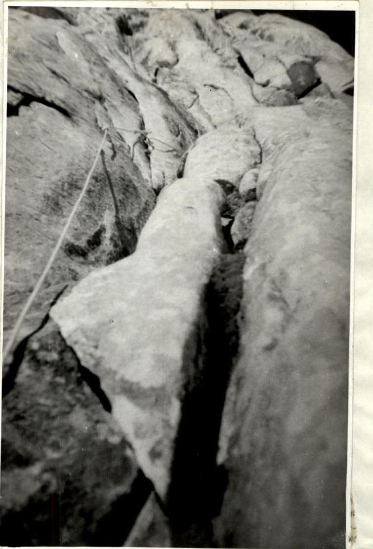
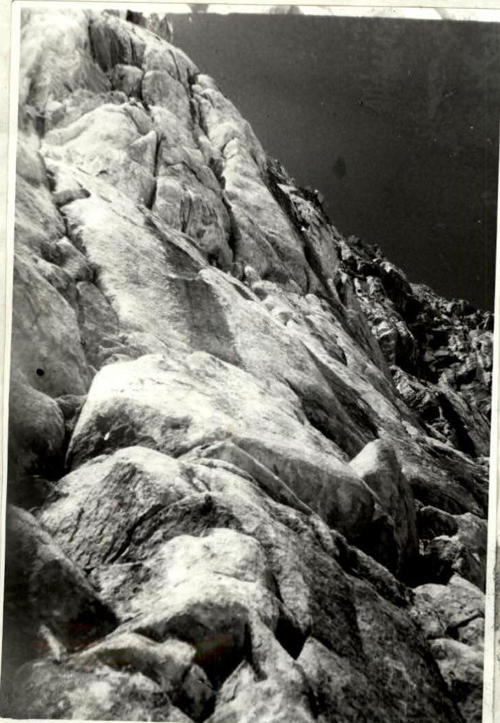
The route via the left bastion of the northeast wall is very logical and safe from rockfall, but it seems impassable due to the lack of significant cracks, crevices, and the presence of many cornices. We came to this conclusion after observing the route… Fortunately, the cornices seen from below are granite blocks, and their passage does not require the use of bolt climbing techniques. On July 12, 1978, we departed at 6:00 AM. When approaching the route from the left of Peak "Materei," rocks started falling after the sun appeared. The 2-meter high bergschrund was not complicated. Beyond the bergschrund, the slope was more icy than firn, requiring step-cutting. We reached the rocks and immediately put on our crampons. The first three meters were smooth due to the retreated glacier - very challenging. It got easier afterwards: a small wall, an inner corner. The inner corner ends with a small ledge, and from the ledge, it overhangs but can be passed with free climbing. Further, there's a wall with good holds, but they are all covered with small debris, requiring great care. The rocks - the left wall is covered with ice, making it very uncomfortable in crampons. It's time to set up a bivouac. On July 13, 1978, we climbed a 40-meter wall, found an excellent platform, and ahead of us was a bastion. We left our backpacks and started the assault on the bastion - undoubtedly the key to the route. There are no cracks for pitons, no holds, everything is smoothed by erosion.
Upward, there's one crack that can only be passed using ladders with Abalakov cams. Although, in principle, one could "bolt" or use 10-15 cm wide wedges. It took three hours to pass the first 30 meters and the plug. The plug is passed slightly to the left. For passing the crack, it's better to use soft ladders since the cams need to be placed deep, and it's hard to stand on aluminum steps. After the plug, there's no alternative - only through one narrow crack on ladders under an overhanging block that blocks the further route. The block is passed on the left in the less steep - 95° part and leads to a ledge. The ledge is for belaying since the previous belay was on ladders. Further, there's a slab, a wall, and an oblique ledge - here you can already find holds and use friction. The ledge leads to an overhanging gap, with a stone jammed at the top. We didn't load it as it doesn't seem entirely reliable. Further, good holds lead to a granite room 8-10 meters high. It's clear that it can only be passed with a bolt. So, we leave a stopper, descend to the exit from the crack, and traverse 10-15 meters with a pendulum to a ridge. On this section, you can only bivouac in hammocks. So, we return to the base of the bastion for the night. On July 14, 1978, we pass the processed sections, and at the top, there's nothing good, everywhere friction and smoothed small holds. We climb along the ridge for 15 meters, and from the right, somehow from under a cornice, an inner corner appears. We descend 2 meters into this corner, where there are places to hammer in pitons. The overall microrelief on the entire bastion is the same; we wait for the end of the bastion where we see many cornices. But the cornices are granite blocks, and their complexity does not exceed category 5. It's easier further on, and we understand that the key has been passed. We didn't reach the ridge and stopped for the night on a good ledge. July 15, 1978. The route to the ridge and along the ridge no longer held surprises and was a typical 5B category route. We began our descent from the summit at 14:00 via the 4B category route.
Route assessment
The route is no less complex than 5B category routes on Peak Amanauz (Dvuzubka) via the W wall, 5B category route on Peak Zapadnyi Dombay via the S wall of Peak TsDSA, 5B category route on Peak SAGU via the pillar of the N ridge. And sections R12–R19 significantly exceed the complexity of the key sections of these routes. The group believes that the route passed is a 5B category route.
Comments
Sign in to leave a comment