ASCENT DOCUMENT 102
- Climbing category: technical
- Climbing area: Alai Ridge
- Peak: Pik Synovey, height approximately 5100 m, ascent route - via the North face.
- Estimated difficulty category: 5B
- Route characteristics: elevation gain — approximately 1100 m. average slope: 55° section lengths: 2nd difficulty category – 160 m, 3rd difficulty category – 190 m, 4th difficulty category – 300 m, 5th difficulty category – 590 m, 6th difficulty category – 40 m.
- Pitons driven: | | for belay | of which for artificial holds | | :---------- | :-------------: | :-----------------------------: | | rock | 49 | 6 | | ice | 54 | 7 | | bolt | 1 | 1 |
- Total climbing hours: 40 hours
- Number of bivouacs and their characteristics:
- On an ice platform in a bergschrund, the platform was processed, the tent was set up fairly normally.
- On a rocky talus shelf, the platform was processed, the tent was set up fairly normally.
- On a rocky ledge, half-reclining, wrapped in a tent.
- Full name of the team leader and participants, their qualification:
- Kozinny Viktor Kirillovich — 1st sports category
- Kozak Leonid Romanovich — Master of Sports
- Smoylovsky Alexander Naumovich — 1st sports category
- Shabokhin Viktor Alekseyevich — Master of Sports
- Team coach: Master of Sports Saprykin V.D.
- Date of departure and return:
August 10, 1977 – August 14, 1977
Pik Synovey (5100 m)
Report on the ascent to the peak SYNOVEY via the North face, July 10-13, 1977
1. Brief geographical description of the climbing area.
The peak Synovey is located in the Alai Ridge in the cirque of the Kosmonavtov horseshoe (Archa-Kanysh gorge area). It is the second peak from the left among the peaks of the horseshoe and, together with Pik Titov, is the highest peak in the cirque. To the north, the peak is bordered by the flat Kosmonavtov Glacier. To the south, the peak has severely degraded, gently sloping slopes composed of sandstone. The Kosmonavtov cirque is a very convenient area for mountaineering and will undoubtedly become one of the popular mountain areas among climbers in the future. The eight peaks surrounding the glacier in a semicircle drop off to the north with kilometer-high walls. Almost all of them had interesting routes ranging from category 3A to 5B-6B difficulty established on them in 1977. A major advantage of the area is the proximity of the routes to the base camp on the moraine of the glacier and the ability to observe groups on almost all routes of the horseshoe from a single point.
2. Brief description of the approach to the route.
The base camp of the Dughoba hostel branch in the Archa-Kanysh gorge was located roughly in the middle of the gorge at the mouth of the Tupon gorge, which leads past Pik Leningradets into the Kosmonavtov cirque. The approach to the intermediate camp on the moraine of the Kosmonavtov Glacier takes about 5 hours. From the camp on the moraine, from where the team was observed, the approach to the route takes 1 hour. The path goes:
- across the moraine rubble,
- then across the flat glacier.
Observation of the route prior to the ascent allowed to identify the main paths of rockfall (to the right of the chosen route, mainly after 15:00) and to plan a safe path across the icefall. The chosen route, as confirmed by the ascent, appears to be the safest and most logical path to the summit via the north face.
Alai Ridge, Archa-Kanysh gorge.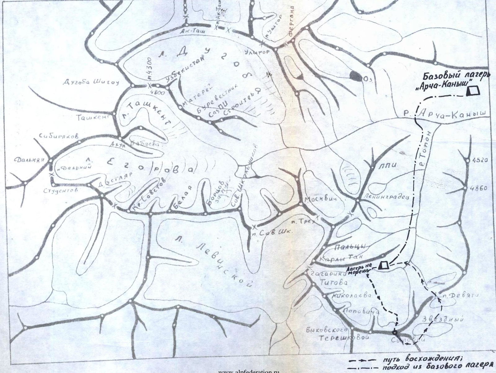
Brief explanation for the table (description of the ascent)
July 10
Departure for the route from the camp on the Kosmonavtov Glacier moraine at 6:00. The approach to the icefall descending from the north face of the peak takes about an hour. The route follows the right part of the icefall. At point R0, we put on crampons and rope up. The section R0-R1 is traversed simultaneously. All subsequent sections feature complex ice terrain requiring top-notch ice climbing skills from the climbers. Immediately on the section R1-R2, complex work begins. The ice slope becomes steeper, reaching 45°, and the last 8 m are at 60°. We have to cut steps. Belay is via pitons, with rope protection. At the end of the section, there is a ledge. From the ledge, we climb up a steep ice chimney. The chimney is traversed with the help of two ladders and rope protection. Further movement is alternating on a slope broken by crevasses, with a slope of 45°. The steepness increases. A 3-meter wall with a steepness of 70° is overcome via an ice chimney using a ladder and rope protection. The path then follows a slope with a steepness of 45°, cut by crevasses. An ice wall is bypassed on the left (section R5-R7). First, a wide crevasse is traversed via a snow bridge, then an ascent up a snow slope with a steepness of up to 60°. Belay is via ice axe. We reach a flat ledge, which is a snow bridge over a large bergschrund. Potential bivouac site. A 2-meter negative wall of the bergschrund is traversed with the help of a ladder, and we approach a second bergschrund via a snow slope. Due to the lack of platforms on the slope above, and also (which played a decisive role) due to the onset of rockfall danger after 15:00 (at this time, the sun illuminates the slope), we decide to stop movement at 15:00. The platform in the bergschrund is reliably protected from possible rocks from above. We cut out a platform on the ice, set up a bivouac. Simultaneously with setting up the bivouac, we process another 120 m of a snow-ice slope with a steepness of 45° and hang rope protection. On the first day, 340 m of complex ice terrain on the icefall are traversed, and 120 m of a snow-ice slope are processed.
July 11
We depart at 7:00. After traversing the negative 2-meter wall of the bergschrund with the help of a ladder, we proceed along the hung ropes. Along a steep ice slope broken by crevasses, we approach a third bergschrund. To the right, there is a rockfall-prone gully, where rockfall is possible after 15:00. From the bergschrund, after overcoming a 3-meter wall with the help of a ladder, we traverse the gully to the right, emerging into the last bergschrund directly under a rocky outcrop shaped like a trident (with teeth pointing down). On the traverse, we have to cut steps — 10 m. The gully is rockfall-prone. The most likely time for rockfall is after 15:00. To reach the rocks, we ascend to the right up an ice slope with a steepness of 70°, first overcoming a 2-meter negative wall with a ladder. The ice is very dense, breaking off in large "lenses"; pitons are difficult to place. The entire ice section when exiting onto the rocks is traversed with step-cutting in a closed stance. The rocks are complex, with a steepness of 75-80°. On the rocks, movement is vertically upwards along a wall (6 m), then along the left side of an inside corner (10 m). The rocks are difficult, climbing is tense, with piton belay. Backpacks have to be pulled up for the entire 40 m. From the inside corner, we exit onto steep, degraded, icy rocks, partially covered with snow. Movement is cautious to avoid dislodging rocks. To the left, along an inside corner, we exit onto a rocky ledge in the center of the "trident" — on the ledge, we build a control cairn. From the ledge, along an inside corner (20 m) with a steepness of up to 70°, we ascend along degraded rocks filled with ice. We emerge onto a snow ridge with rocky ledges on the left part. On one of the ledges, we set up a bivouac, processing a platform for the tent. The bivouac is normal. On the second day, 280 m are traversed. One of the most complex sections of the route is overcome: R10-R11 — a steep slope of dense ice, R11-R12 — a complex rocky wall.
July 12
Departure at 8:00. From the bivouac site, the path follows a gentle ridge (40 m, up to 30°). On the ridge, we overcome a rocky 2-meter gully filled with ice. A rocky gendarme on the ridge is bypassed on the right along degraded, icy rocks. Beyond the gendarme, we exit onto a steep rocky ridge (60 m). The rocks are of the "sheep's forehead" type, often with ice. To the right, in close proximity, there is a rockfall-prone gully (rockfall possible after 15:00). From the ridge, through a 1.5-meter chimney, we exit onto severely degraded rocks to the right of a clearly defined "bastion". On the rocks, there is snow. Along complex rocks, we ascend vertically upwards under the red monolithic walls of the "bastion" (80 m). Climbing is tense. Along the red walls, on snowy rocks, we exit into a wide chimney. From the chimney, we traverse to the right upwards along rocks filled with ice, with a steepness of 80° (5 m), using a ladder, and then vertically upwards (80 m) along a wide inside corner filled with ice. In some places, we have to overcome chimneys with "plugs". On individual sections, the steepness of the rocks reaches 90°. Climbing is very difficult, with the use of artificial holds. Along the inside corner, we exit onto a small, safe ledge before a steep, icy wall. The last 40 m require pulling up backpacks. Due to the significant physical and psychological strain of the past day, at 17:00, we decide to set up a bivouac. On the ledge, only 2/3 of the tent fits, so we spend the night in a half-reclining position. On the third day, 310 m are traversed. The most complex section of the route is behind us: the exit onto the "bastion". Ahead of us is a vertical 40-meter wall, entirely filled with ice.
July 13
We depart on the route at 7:00. Climbing is very difficult. In two places, we have to use ladders; one bolt piton is driven. In the upper part, we exit along an inside corner filled with ice, to the left onto a ledge. Backpacks are pulled up. On the ledge, a bivouac is possible. From the ledge, to the right, along an ice slope, we exit onto a snowy pre-summit ridge. Movement is in crampons on the front teeth. The ridge is rocky and icy. Small ice walls on the ridge are overcome with step-cutting. Two rocky gendarmes of medium difficulty are overcome head-on. On the ridge, there are places suitable for bivouacs. The last 60 m are traversed on the right side of an ice "knife edge", where the slope steepness increases from 50° to 60°. On the last 5 m, the slope steepness reaches 70°. Movement is initially on the front teeth of crampons, and the last 20 m involve step-cutting. At 16:45, we reach the main ridge of the peak. Along talus to the left, bypassing a gendarme on the right as we go, after 80 m, we reach the cairn on the summit. On the last day, 310 m are traversed. The most complex sections: R15-R16 — a vertical, icy wall and a steep exit onto the main ridge of the peak. Descent from the summit is along the southeast edge into a col on the eastern ridge branching off from the peak Synovey. From the col, there are three 40-meter rappels, followed by a descent along ledges into the Sauk-Jailau gorge. Return to the camp in the Kosmonavtov cirque is via the Devyati Pass.