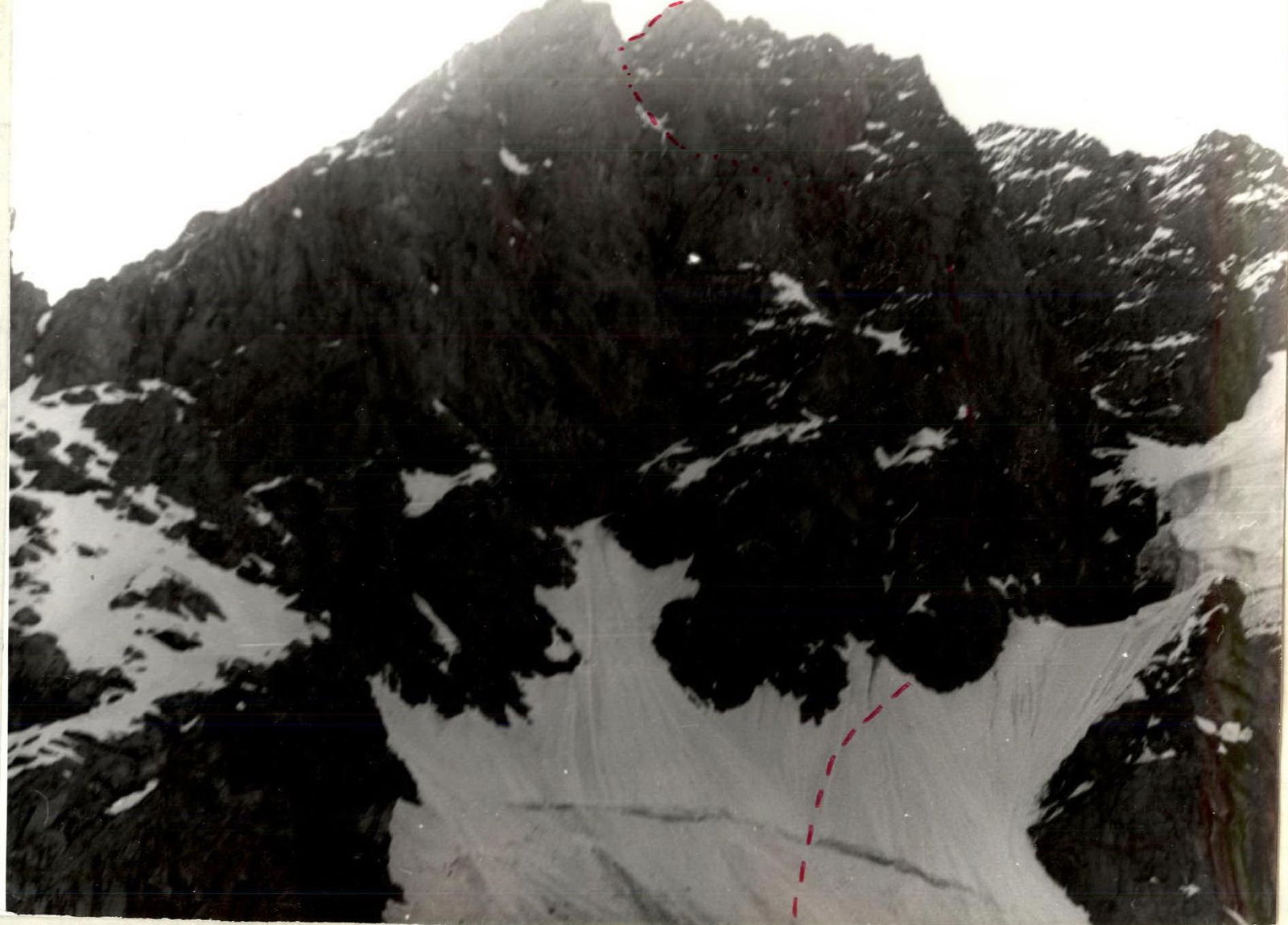
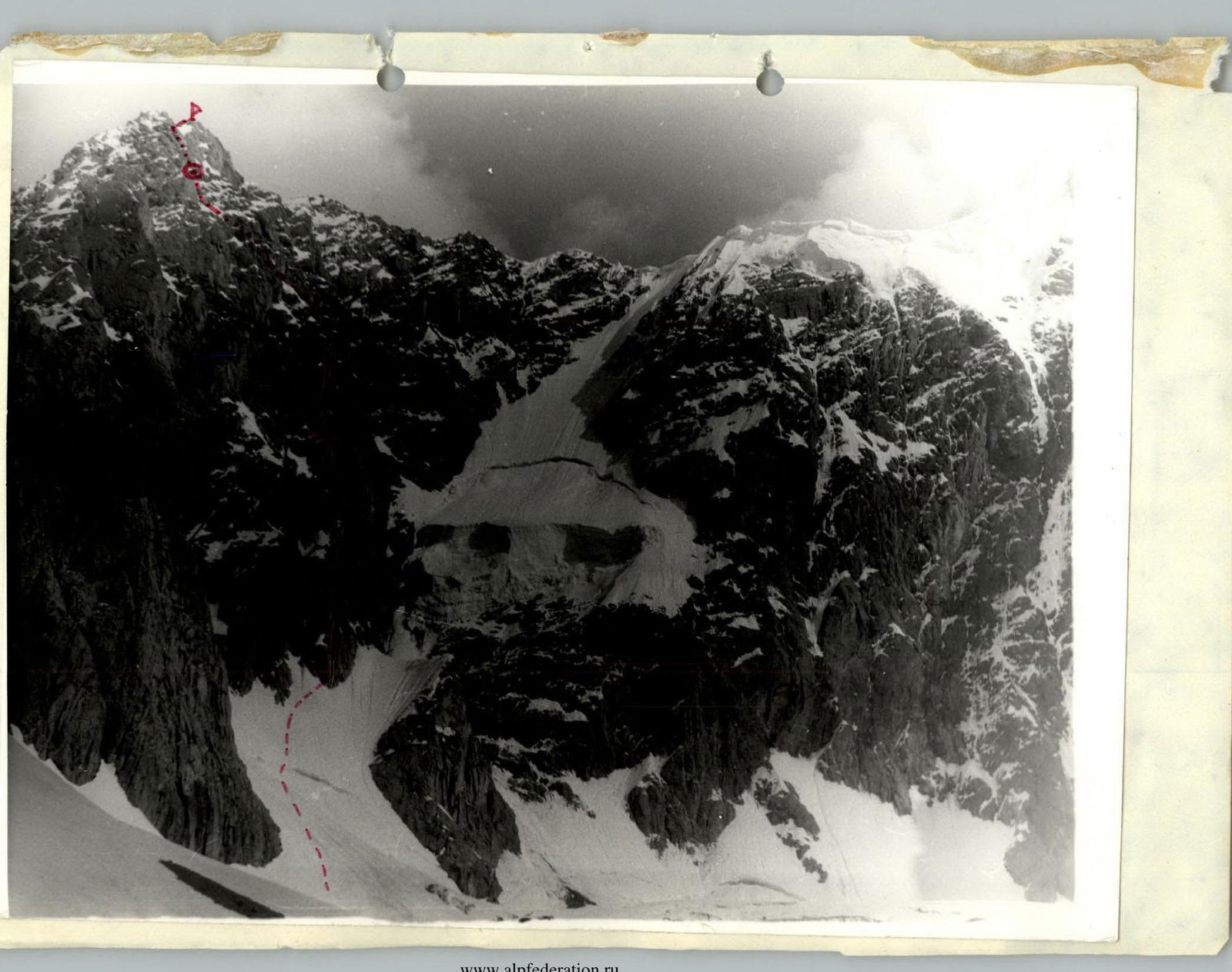
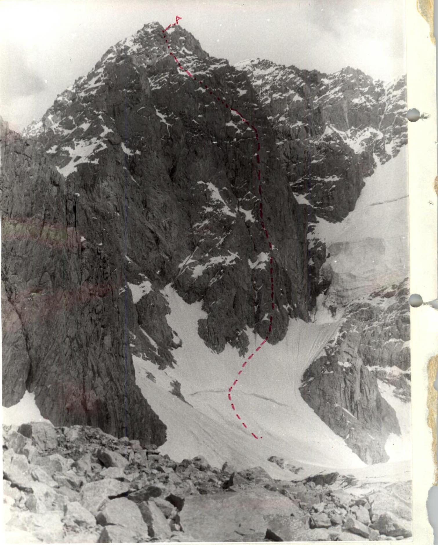
Sauk-Dzhaiylau South peak via the West wall, 6A cat. (Onysko route) Pamiro-Alai 5.1.1. Alai Ridge
Passport
- Technical class.
- Pamir-Alai, Archa-Kanysh valley.
- Sauk-Dzhaiylau South peak via the West wall.
- 6A cat. (3rd ascent)
- Height difference 1330 Wall section height difference 980 Average steepness of the wall section 73°. Route length 1440. Sections of 5–6 cat. 720
- Rock, nut, and ice screws used. 82/9 93/6 25/3
- Team's walking hours: 20.5 days – 3.
- Two overnight stays: 1st on a scattered, half-reclined position. 2nd on a platform carved in a snow-ice slope.
- Team leader Popovich Vadim Vitalievich — CMS
participants:
- Marbakh V.R. — CMS
- Isupov S.M. — CMS
- Ravilov R.A. — CMS
- Coach Marbakh Viktor Rokhusovich.
- Departure to the route: 25.07.1992. Summit — 27.07.1992. Return — 27.07.1992.
- Organization — l/o "Promalp" N. Tagil, Sadovaya st., 2, 622023, ph. 22-66-48.
Main.
Tactical movement scheme
It was decided to ascend via interaction of rope teams, with lead climbers carrying lightened backpacks (personal items) and no backpacks at key sections. Rope teams worked on double ropes. On rocky sections, the Popovich-Marbakh team led, while on snowy and icy sections, the Isupov-Ravilov team took the lead. (When moving on ice and rocks, protection was provided by pitons). After reaching the pre-summit ridge, the teams moved autonomously and simultaneously (using rock outcrops for protection). The ascent was led by Popovich V.V.
Overnight stays were planned:
- 1st on a long, horizontal ledge at an altitude of 4050 before the end of the 2nd rhomb;
- 2nd on the pre-summit ridge.
It was planned that one team would prepare the bivouac site while the other would work on the route (hanging free ropes and descending to the bivouac site).
Changes in weather conditions on the first day prevented the team from fully executing the tactical plan. On the second day, the team made up for lost time.
Team's tactical actions on the route
July 25
- 8:00 — departure from camp to Sauk-Dzhaiylau glacier.
- 8:00 — approach to the start of the route. Crossing the bergschrund.
- The Isupov-Ravilov team leads, protection via ice screws.
- Teams start moving simultaneously, later using fixed ropes.
- 9:20 — reaching the base of the 1st rhomb, start of the rocky section of the route. Popovich-Marbakh team leads. Piton protection.
- 14:00 — reaching the grey-colored rocks.
- Sudden change in weather conditions (snowfall).
- The group gathers on a ledge at 3900 m, waiting out the bad weather.
- At 16:00, the Popovich-Marbakh team continues working on the route, climbing is difficult, 5–6 cat. Often have to use balance; upward movement is hindered by wet rocks. The choice of handholds is limited, and feet slip on friction.
- The Isupov-Ravilov team prepares the bivouac site — expands the ledge.
- 18:00 — two pitches completed.
- Isupov-Ravilov team prepares the bivouac.
- Marbakh-Popovich team descends.
- Overnight stay in a scattered, half-reclined position.
July 26
- 8:00 — grey-colored rocks. Difficult free climbing.
- The route is interesting; rocks form vertical slabs and walls of 30–40 m; need to use artificial aids.
- Micro-relief is reliable. Nuts and small pitons go well.
- At 15:00 — reaching a ledge; overhang on the left, long couloir on the right to the pre-summit ridge.
- Couloir is snowy and icy, with separate rocky sections covered in ice.
- Isupov-Ravilov team takes the lead; all team members wear crampons.
- Alternating movement on fixed ropes, with protection.
- Ice screws and rock pitons are used for protection.
- Vertical ice wall, 3–4 m. Isupov S. leads with two hammers; ice is fragile on top, so ice screws are used as artificial aids.
- At 18:00, we are two pitches away from the pre-summit ridge.
- We move to the right; a snowy ledge allows us to set up a tent.
- Popovich-Marbakh team carves out a bivouac site.
- 4560 — Isupov-Ravilov team works on another two pitches until 19:00.
July 27
- 8:00 — departure from bivouac.
- 9:00 — reaching the pre-summit ridge. Rocks, 5 cat.
- Teams move simultaneously.
- 9:30 — reaching the summit.
- Descent to the glacier via the East peak, then to the 4130 col, and from the col to Sauk-Dzhaiylau glacier.
- At 17:00 — in camp, meeting the observation group.
July 28
- Return to base camp.
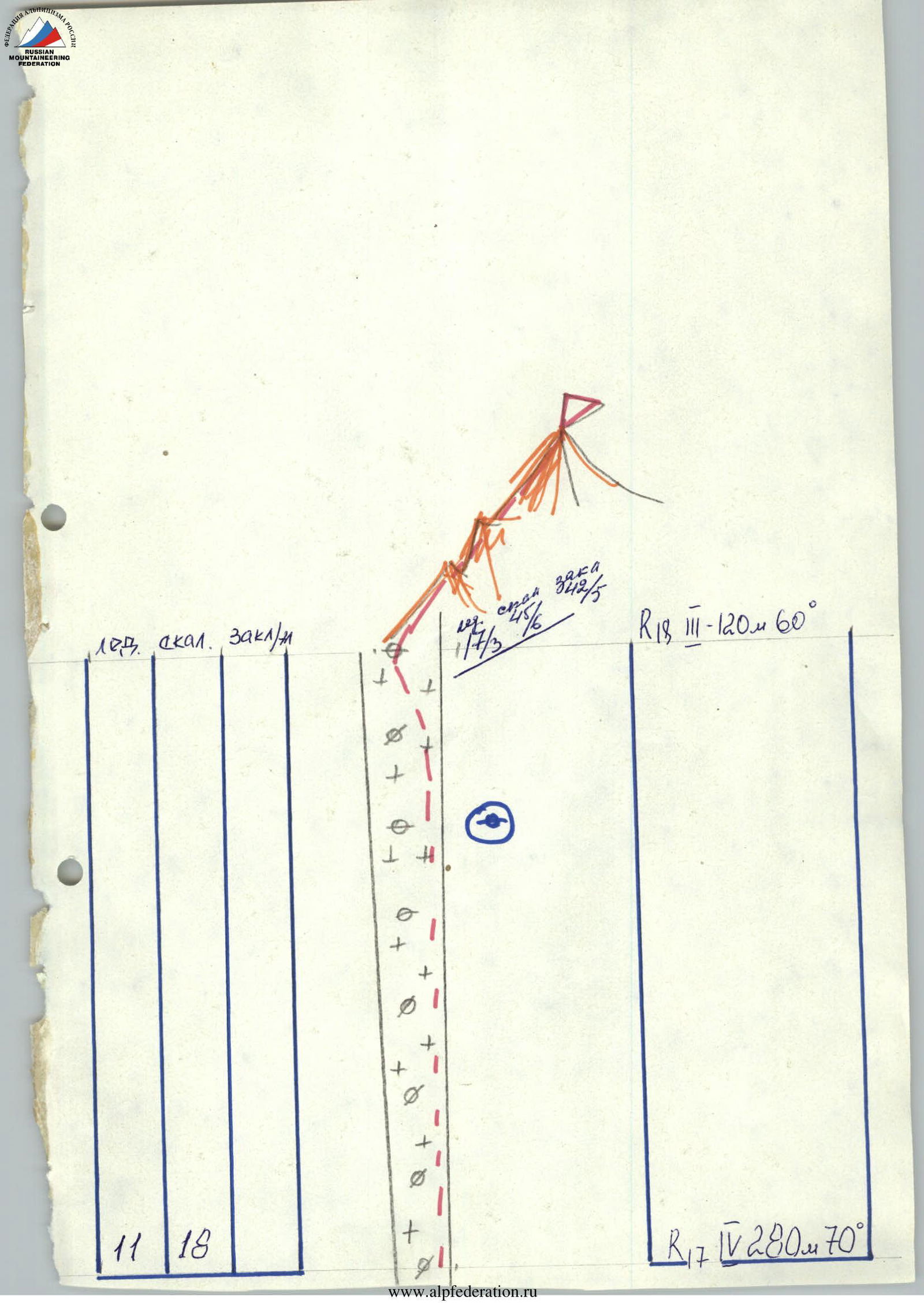
Route scheme in M1:2000 symbols
| 108 | OKGA | 3ok (32) |
|---|---|---|
| 43 | 4 3/3 | 2 / 2 |
| 2 | 5 | 4 |
| 2 | 12 | |
| 3 | 6 | |
| 3 | 6 | |
| 7 / 3 | 6 / 3 | |
| 4 | 6 | |
| 5 / 3 | 5 / 1 | |
| 3 | 6 | |
| 6 | 6 |
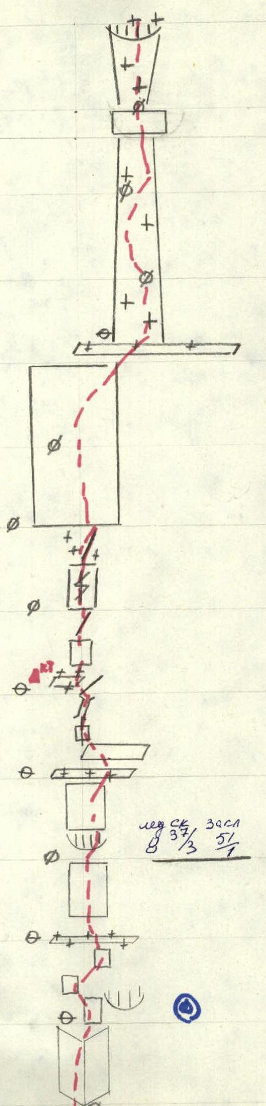
 R14 100 m, 1, 70° R13 80 m, 1, 75° R12 40 m, 1, 70° R11 40 m, 1, 70° R10 40 m, 6А3, 85° R9 40 m, 6, 85° R8 40 m, 6А3, 85° R7 40 m, 1, 70° R6 40 m, 6, 80°
 www.alp-federation.ru↗
Route description by sections
- R0 (0–1): 280 m, 3 cat., 60°. Snowy-ice section. Bergschrund 3 m. Movement towards the base of the second rhomb, towards the inner corner. In the lower part, teams move simultaneously. In the upper part, alternating movement on fixed ropes, protection via ice-rock pitons.
- R1 (1–2): 40 m, 5 cat., 70°. Movement through the inner corner, free climbing. Rocks are damaged, many loose stones. In the lower part, rocks are covered with snow.
- R2 (2–3): 40 m, 4 cat., 65°. Walls 5–8 m, small ledges. Ridge. Loose stones are encountered.
- R3 (3–4): 40 m, 5 cat., 70°. Cleft, passage via free climbing, rocks have a pink tint.
- R4 (4–5): 40 m, 5 cat., 70°. Wall with an overhang, bypass on the left. Lower part is wet. Free climbing, exit to a ridge. Rocks are icy.
- R5 (5–6): 80 m, 5 cat., 75°. Rocks have a large-block structure. Wall, free climbing. Start of movement through a crack from left to right.
- R6 (6–7): 40 m, 6 cat., 80°. Wall with an inner corner, difficult climbing. Rocks are distinctly grey.
- R7 (7–8): 40 m, 5 cat., 70°. Walls 10–15 m. Micro-relief is reliable.
- R8 (8–9): 40 m, 6А3 cat., 85°. Small, narrow ledge. Grey-colored wall. Cracks are encountered, which can be used for small pitons as artificial aids.
- R9 (9–10): 40 m, 6 cat., 85°. Grey-colored rock wall. Passed via free climbing. Movement from left to right. After the overhang, directly upwards.
- R10 (10–11): 40 m, 6А3 cat., 85°. Vertical ledge, potential bivouac site. Cleft. Overhang. Requires artificial aids. Chimney.
- R11 (11–12): 40 m, 5 cat., 70°. Large ledge, can be used for bivouac. Rocks have a large-block structure. Wall 5–6 m, exit to a ridge.
- R12 (12–13): 40 m, 5 cat., 70°. Grey-colored rock. With a cleft. Passed via free climbing. Nuts go well; many vertical cracks.
- R13 (13–14): 80 m, 5 cat., 75°. Long wall. Passed via free climbing. In the upper part, rocks are wet. Loose stones are encountered.
- R14 (14–15): 100 m, 5 cat., 70°. Large ledge. Overhang on the left, couloir on the right. Movement to the right through a snowy-icy couloir. Protection via rock and ice pitons.
- R15 (15–16): 15 m, 6А3 cat., 90°. Rocky wall with an overhang. Rocks are icy; requires artificial aids.
- R16 (16–17): 35 m, 5 cat., 70°. Snowy-icy couloir, in the upper part — vertical ice wall 35 m.
- R17 (17–18): 280 m, 4 cat., 70°. Snowy-icy couloir leads to the pre-summit ridge. Protection via rock and ice pitons.
- R18 (18–19): 120 m, 3 cat., 60°. Pre-summit ridge. Autonomous team movement.