ASCENT PASSPORT
- Climbing category: technical
- Climbing area: Alai Ridge (northern spur)
- Peak: South-East Sauk Jailyau from the north (third ascent), 4730 m
- Difficulty category: 5A
- Route characteristics: height difference 1210 m from the col at 600 m average steepness from the col 59° section lengths see table
- Pitons used for protection to create ITO: rock — 106 ice — 3 bolt —
- Number of climbing hours: 17
- Number of nights and their characteristics: 2 (both on the col)
- Surname, name, patronymic of the leader and participants, their sports qualification: Okhrimenko V.N. — leader, 1st sports category Kharinyak I.V. — participant, 1st sports category Bondarev V.M. — participant, 1st sports category
- Team coach — Kovtun V.G.
- Departure to the route: July 25, 1978; return: July 27, 1978
 www.alpfederation.ru↗
 www.alpfederation.ru↗
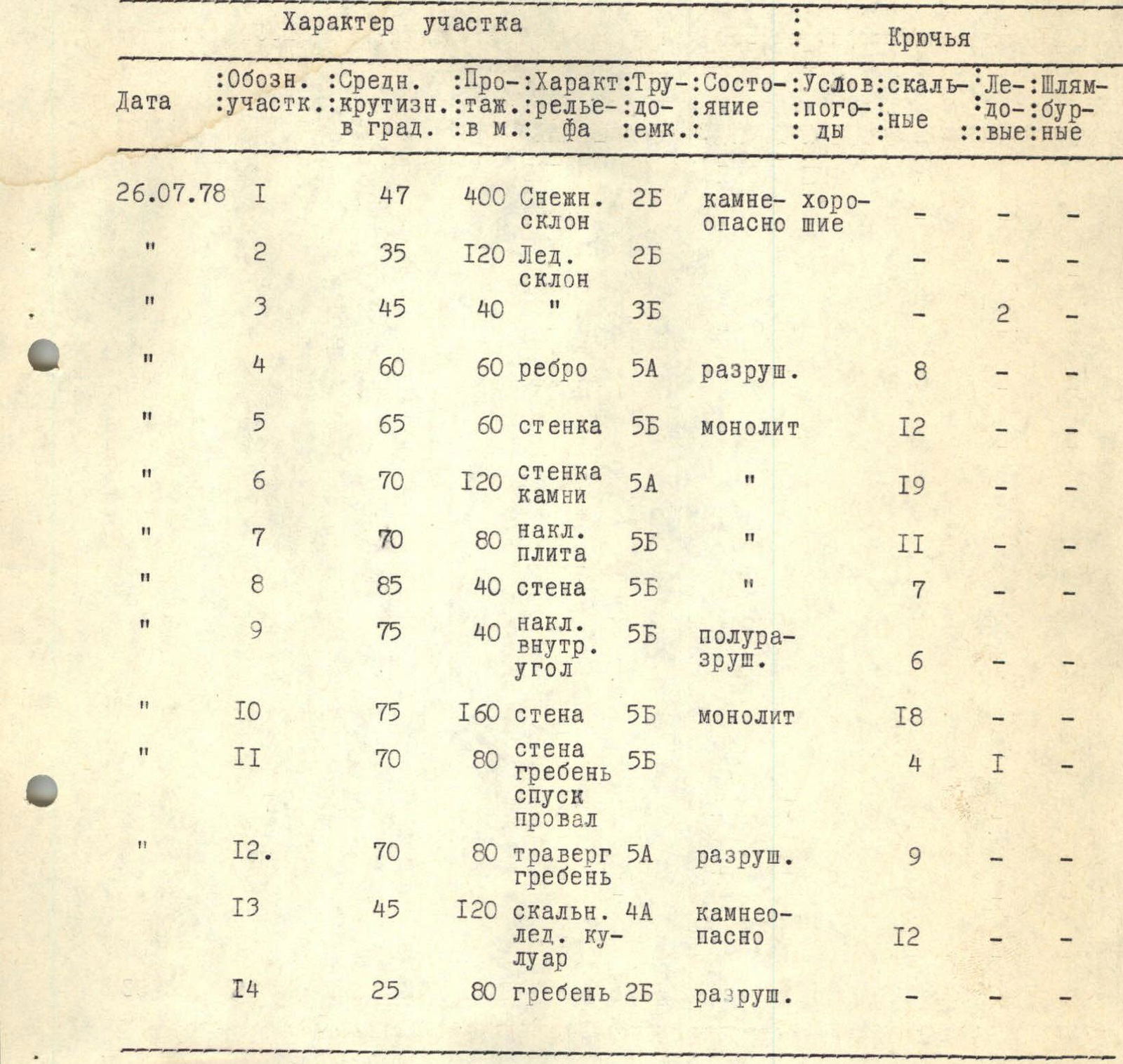
Characteristics of the section
| Date | Section designation | Average steepness in degrees | Length in m | Relief characteristics | Labor intensity | Condition | Weather conditions | Rock pitons | Ice pitons | Bolt pitons |
|---|---|---|---|---|---|---|---|---|---|---|
| 26.07.1978 | 1 | 47 | 400 | Snow slope | 2 | rockfall hazard | good | - | - | - |
| 2 | 35 | 120 | Ice slope | 2 | - | - | - | - | - | |
| 3 | 45 | 40 | - | 3 | - | - | - | 2 | - | |
| 4 | 60 | 60 | ridge | 5 | destroyed | - | 8 | - | - | |
| 5 | 65 | 60 | wall | 5 | monolith | - | 12 | - | - | |
| 6 | 70 | 120 | wall, rocks | 5 | - | - | 19 | - | - | |
| 7 | 70 | 80 | inclined slab | 5 | - | - | 11 | - | - | |
| 8 | 85 | 40 | wall | 5 | - | - | 7 | - | - | |
| 9 | 75 | 40 | inclined inner corner | 5 | semi-destroyed | - | 6 | - | - | |
| 10 | 75 | 160 | wall | 5 | monolith | - | 18 | - | - | |
| 11 | 70 | 80 | wall, ridge, descent, gap | 5 | - | - | 4 | 1 | - | |
| 12 | 70 | 80 | traverse of the ridge | 5 | destroyed | - | 9 | - | - | |
| 13 | 45 | 120 | rock-ice couloir | 4 | rockfall hazard | - | 12 | - | - | |
| 14 | 25 | 80 | ridge | 2 | destroyed | - | - | - | - |
Descent via the ascent route:
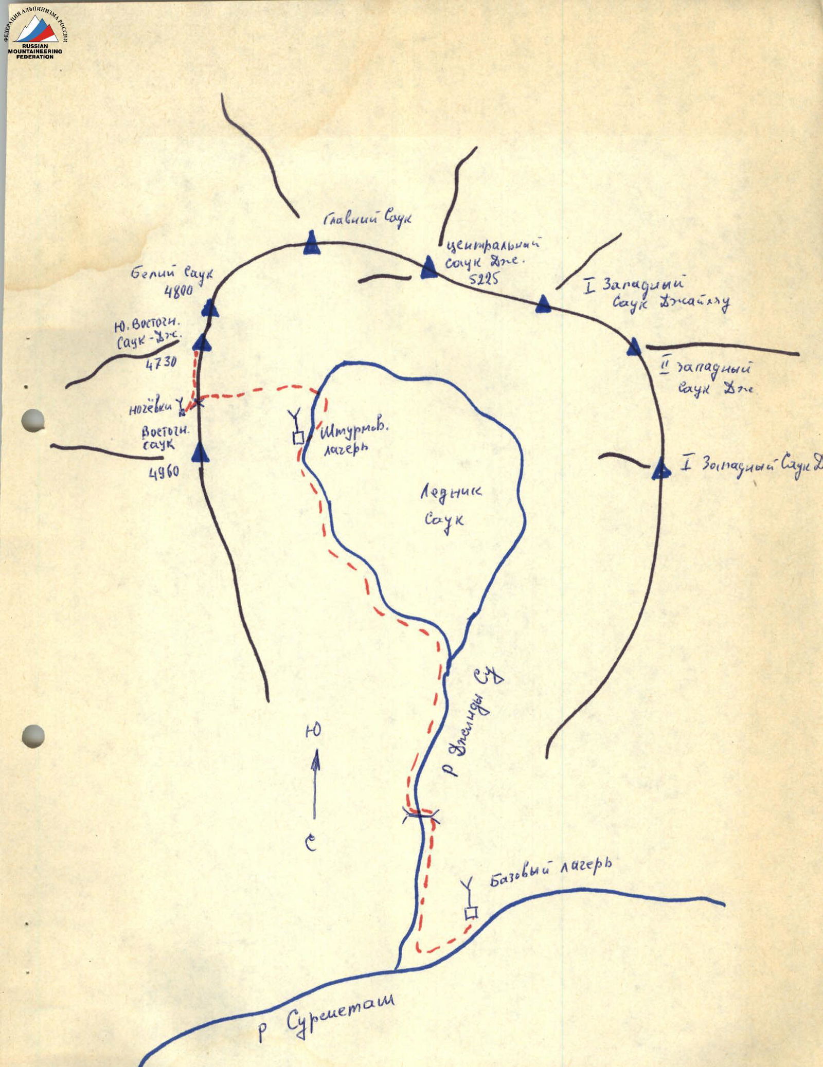
Brief description of the approach to the route
The Sauk Jailyau massif (cirque) is located in the northern spur of the Alai Ridge. The cirque is horseshoe-shaped, open to the north. Inside the cirque, there is extensive glaciation — a glacier approximately 1 x 3 km, and snow-ice slopes of northern and eastern exposure.
The Dzhindy-Su river flows out of the glacier, which flows through a deep canyon into the Surmetash valley and joins the river of the same name.
The glacier tongue ends in an icefall, from which blocks of ice periodically break off and fall through the canyon.
The Dzhindy-Su river:
- is quite full-flowing;
- is difficult to cross in the second half of the day.
From the base camp, located at the confluence of the Surmetash and Dzhindy-Su rivers, we ascend along the latter on the right (in the direction of travel) side of the river to the "baranii lby" (rocky outcrops). 200 m before reaching them, we descend directly to the river, to its narrowest point. We cross to the left (in the direction of travel) bank of the Dzhindy-Su river. Then, along a steep grassy slope, we reach the lateral moraine of the glacier and move along it. Moving along the northern spurs of the peak East Sauk Jailyau, we move in the direction of Central Sauk Jailyau and descend from the scree onto the glacier. Along the glacier, we move towards the col between East and South-East Sauk Jailyau. The ascent to the col goes along a steep snow-rock couloir with a steepness of 45°–50° and is 5 x 80 m. On the left side of the col, on the moraine, are the overnight stays of the assault camp. Altitude 4130 m. From the base camp to the overnight stays on the col is a 10–11 hour ascent.
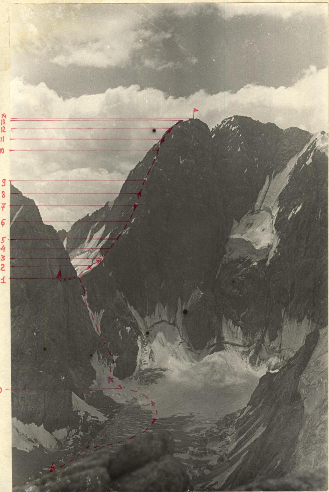
Route description
From the overnight stays, we descend slightly down to the col, and from it, along a snowy, then icy slope (with crampons), we reach a rocky ridge. After reaching a convenient ledge, we remove our crampons and put on galoshes. Further ascent goes along a destroyed ridge, which leads to a 60-meter wall.
After passing the wall, we reach:
- a chimney;
- then a monolithic smoothed slab (difficult climbing).
Further, we reach an inclined inner corner consisting of semi-destroyed, loose rocks (rockfall hazard).
The last 160-meter wall leads to a pre-summit tower, which is topped with a wide, flat monolith. Along the ridge, descending 10 m down, we reach a gendarme in a gap between the pre-summit tower and the summit. The ascent to it goes along a narrow, winding crevice, and the descent from it is along a fixed rope (which is then used for ascent during the descent from the summit).
Further along the ridge, we pass:
- a second large gendarme;
- reach the final pre-summit ascent, where the control cairn is located.
The pre-summit ascent is a rock-ice, rockfall-hazardous couloir. Further along the destroyed ridge, we reach the summit.
The journey from the overnight stay on the col to the summit takes 11 hours. The descent from the summit to the gendarmes is by climbing, and after the gendarmes — from the last 160-meter wall and down to the col — by rappel. The entire descent took 6 hours.