9.I. Ascent Passport
Ascent category — technical
Ascent region (№ according to KTMTTV) — northern spur of the Alay Ridge (5.1)
Peak, its height, and ascent route — South-Eastern Sauk-Djaylyau, 4730 m, from the north
Expected category of difficulty — 5B
Route characteristics:
- height difference: from the assault camp — 1210 m, from the saddle — 610 m
- average steepness — 63°
- purely rock section — 67%
- length of sections I — забито крючьев для страховки: for creation and T.O.
| Actual | For creation and T.O. | |
|---|---|---|
| rock | 108 | 0 |
| ice | 4 | 0 |
| piton | 7 | 0 |
Number of travel hours — 37 hours. Number of nights and their characteristics — 2 (one — on the saddle on the lateral moraine, the second — on the pre-summit ridge on snow with space for two tents)
Surname, first name, patronymic of the leader and participants, and their sports qualification
- Viktor Viktorovich Markelov — leader, Master of Sports of the USSR
- Gennadiy Alekseyevich Gavrilov — participant, Master of Sports of the USSR
- Mikhail Vitalyevich Petrov — participant, Master of Sports of the USSR
- Vadim Karlovich Ivashev — participant, Master of Sports of the USSR
- Aydar Barievich Nezamutdinov — participant, Master of Sports of the USSR
- Valentin Nikolayevich Krapivin — participant, Candidate for Master of Sports of the USSR
- Leonid Fedorovich Kratovich — participant, 1st sports category
Team coaches:
- senior coach V.G. Staritskiy
- coach-leader A.B. Nezamutdinov
Date of departure and return: July 19, 1977, July 23, 1977

1. Brief geographical description and sports characteristics of the ascent object
The Sauk-Djaylyau massif (cirque) is located in the northern spur of the Alay Ridge, almost a kilometer above it. The cirque is horseshoe-shaped, open to the north. Inside the cirque, there is significant glaciation — a glacier approximately 1×3 km and snow-ice slopes of northern and eastern exposure, reaching the peaks.
The glacier feeds the Dzhindy-Su river, which flows through a deep canyon into the Surmetash valley and merges with the river of the same name. The glacier tongue ends in an icefall, from which blocks of ice occasionally break off and tumble down the canyon.
The Dzhindy-Su river is quite full-flowing and becomes difficult to cross in the second half of the day.
In the southern part of the horseshoe, there are three dominant peaks:
- Central (named by the first ascenders)
- 1st Western
- Main
The height of the Central peak is 5225 m. The 1st Western and Main peaks are slightly lower.
In the western part of the horseshoe, there are the 2nd Western and 3rd Western peaks of Sauk-Djaylyau.
In the eastern part of the horseshoe, the following peaks can be identified:
- Snowy Sauk-Djaylyau (4800 m)
- South-Eastern (4730 m)
- Eastern (4960 m)
The last peak is separated from the main massif by a deep saddle (4130 m). Between the other peaks of the massif, the ridge does not drop below 4500 meters. From all peaks, ridges extend outward from the horseshoe. A short ridge extends inward from a point slightly east of the Central Sauk-Djaylyau.
All peaks from the Central and westward are snow-rock-ice; to the east, they are primarily rock. Except for the 3rd Western peak, all routes from the cirque to the peaks of the massif are logical and not below 5B category of difficulty, and to the Central and Main peaks — 6B category of difficulty. Most routes are of the wall type. The eastern ridges to the Eastern Sauk-Djaylyau and South-Eastern Sauk-Djaylyau peaks are also approximately 5B category of difficulty.
Routes with snow-ice sections are better climbed at the beginning of summer (June) when the snow cover remains. Snow-ice slopes:
- are very steep
- regularly experience icefalls
- during the day, avalanches occur, sometimes sweeping over, in particular, the rock buttress of the 1st Western Sauk-Djaylyau peak.
The Main Sauk-Djaylyau peak faces the cirque with a nearly kilometer-high wall, practically unlit by the sun.
By the time the team arrived in Fergana, the Central Sauk-Djaylyau peak had already been reached by a team from Uzbekistan. The outstanding achievement was marred by the tragic loss of the first ascenders. The LenGorsportkomitet team, for moral reasons, excluded routes to the Central Sauk-Djaylyau peak from their possible objectives, even via different paths.
All routes to the peaks of the Sauk-Djaylyau massif from the cirque are approached from the north and along walls with a northern orientation.
Due to very warm weather (the cause of many natural disasters in the region that year), the route to the Western Sauk-Djaylyau peaks was ruled out because the rock buttresses are regularly swept by avalanches. The choice of ascent object was left to the peaks in the eastern part of the massif.
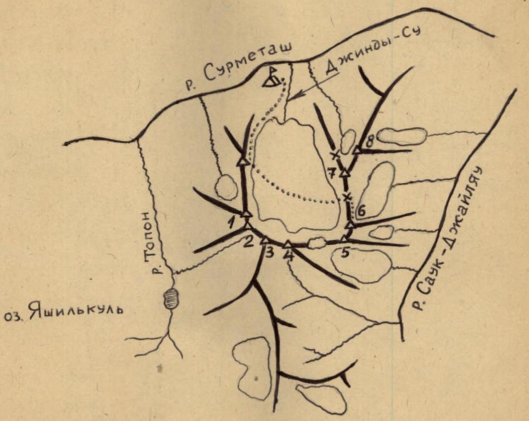
1 — Sauk Western I tower 2 — Sauk Western II tower 3 — Sauk Central 4 — Sauk Main 5 — Sauk White 6 — Sauk South-Eastern 7 — Sauk Eastern 8 — Sauk Dvuzubka
2. Brief description of ascent conditions in the given region
2.1. Relief features
The rocks of the massif are composed of granites, syenites, and granodiorites, with a predominant angle of inclination of slabs and walls of the macro-relief of 70°–75°, starting at various levels from the Northern Sauk-Djaylyau glacier. The lower part of the slopes is heavily destroyed; the middle part is pedestal-like, monolithic, with few fractures and poorly developed micro-relief (requiring passage of sections 10–15 m on friction); the upper part has greater dissection with good fractures for belaying, often filled with ice on the pre-summit section.
It should be noted that rocks from 4000 m and practically to the summit on the northern side of the massif are overgrown with lichens, which, under conditions of bad weather, abundant snow and ice melting, create particularly difficult and hazardous climbing conditions (cramp-ons do not hold due to the lack of micro-relief and smoothness of the rocks, and vibram and galoshes slip on the wet lichen).
2.2. Geological description of the ascent object
In the lower part of the route from the saddle to a height of 4370 m, granites are encountered, consisting of feldspar, biotite, and quartz.
In the granitoids, two types of fracturing are observed:
- separate fractures
- fracturing associated with tectonic processes
In tectonic zones, granites acquire a gneiss-like appearance. In this part, the granite massif has undergone intense weathering, likely due to its gneiss-like appearance. The granites in this part are mostly fine-grained.
From a height of 4400 m to 4600 m, the appearance of the granites changes quite sharply. They become:
- more coarse-grained
- less weathered
- massive
They mainly exhibit fractures of separateness. Block sizes average 2×1.5 m. Vertical fractures of separateness are predominantly developed. The granites in this section have a pinkish hue, likely due to microcline.
In the upper part, the mass appearance of the granites has not changed much, but more intense development of separateness fractures is observed. Block sizes are significantly smaller (0.75×0.5 m). In this part, the granites have acquired a porphyritic appearance due to:
- clearer separation of feldspars
- an increase in their size
Thus, the route passed mainly through a granitoid massif, which likely encompasses the entire Sauk-Djaylyau cirque.
2.3. Weather conditions
The ascent region in July-August can generally be characterized by good weather, but the Sauk-Djaylyau cirque has a microclimate associated with:
- the high altitude of the massif
- significant glaciation
- the enclosed nature of the cirque
In the cirque, local cloudiness or fog practically forms daily from 12:00 to 18:00, developing from cloud fragments coming from the Alay valley, with precipitation falling in the form of snow or graupel.
2.4. Remoteness from populated areas, alpine camps, and communication routes; exploration of the region
The region is quite remote from populated areas and is:
- a day's journey from the nearest populated area, Karaul
- a day's journey from the nearest highway from Karaul to Lingar
From the Duyuuba alpine camp to the Sauk-Djaylyau valley, one can reach in a day via the Ak-tash pass (4420 m) or through the Trum pass from the Shahimardan settlement.
The Sauk-Djaylyau massif first attracted attention as an ascent object by V.A. El'chibekov, G.N. Ovcharov, S.M. Savvon, and other climbers during their first ascents of the Shant peak, located opposite the Dzhindy-ou river valley and on the right side upstream of the Surmitash valley. However, until this year, there were no attempts at ascents due to the inaccessibility of the cirque and the complexity of the routes to the Sauk-Djaylyau peaks. Until 1975, no real attempts at ascents or even explorations were conducted. Available maps do not accurately reflect the layout of the ridges of the Sauk-Djaylyau massif.
3. Reconnaissance exits
The beginning of reconnaissance actions dates back to September 1975 when a group consisting of:
- Yu.D. Shulga
- B.I. Vikharev
- Z.I. Popolzina
- S.I. Shaposhnikov
ascended the left side of the Dzhindy-Su river and conducted photography of the Sauk-Djaylyau cirque.
In August 1976, the reconnaissance of the massif was continued by climbers: A.I. Ilyin, V.F. Pukhovitskiy, V.V. Markelov, E.A. Lobachev, L.F. Kratovich. The last three conducted a detailed reconnaissance of the routes, rock character, rockfall regime, and made a more detailed photo survey.
During the reconnaissance in 1975–1976, as well as during the crossing in 1977 to the left side of the Dzhindy-Su river, the objective danger of crossings and ascent along the left lateral moraine into the Sauk-Djaylyau cirque was established. To ensure a safe ascent and shorten its duration, on July 10 and 11 of this year, the duo Markelov V.V. — Kratovich L.F. explored and processed a route into the upper cirque of Sauk-Djaylyau along "goat paths" with a steepness of 40°–45°. During this, 240 m of rope were fixed. This measure ensured the safety of the approach paths to the assault camp and reduced the ascent time by 1.5–2 hours.
Verbal reconnaissance of the Sauk-Djaylyau massif in 1977 was conducted during the first passage along a rigid ridge to the Leninets peak, when the team, in full composition, viewed the aforementioned massif from the west from the summit and noted a greater average steepness of the southern walls (future descent paths) than the northern ones (future ascent paths).
The main reconnaissance exit was performed by a group consisting of: Kratovich L.F. — leader, Markelov V.V., Gavrilov G.A., Nezamutdinov A.B., Krapivin V.N., Lobachev E.A. during an ascent to the Eastern Sauk-Djaylyau peak along the northern ridge.
The group became more familiar with:
- the character of the rocks
- the location and size of fractures in them
- possible descent paths along the eastern outer ridges
- the route along the northern wall to the South-Eastern Sauk-Djaylyau peak
However, due to bad weather, the group was unable to examine the ridge section from the South-Eastern to the Main Sauk-Djaylyau in more detail.
In addition to the first ascent of the Eastern Sauk-Djaylyau peak, the result of this exit was the clarification by the group of the route for the USSR Climbing Championship — Main Sauk-Djaylyau with an ascent to the South-Eastern Sauk-Djaylyau from the north (or along the northern wall), with a backup option — only an ascent to the South-Eastern Sauk-Djaylyau peak.
Simultaneously, it was established that there are no simple descent paths from the peak of the massif. Failure to consider the complexity of descents by ascending groups could lead to an emergency situation (for example, the descent from the Eastern Sauk-Djaylyau along the simplest path took 1.5 days and required the organization of ten 80-meter rappels, not counting traverses and descents using the sports method).
The group did not make preliminary deliveries to the route. Some products and equipment were delivered in advance by team members only to the assault camp.
4. Organizational and tactical ascent plans, adjustments made before the ascent, and their rationale; tactics for conducting the ascent
By the time the reconnaissance and training ascents were completed, due to exceptionally unfavorable hydrological conditions that year (floods, river overflows, earthquakes, mudflows), the team lost three days at the beginning of the gathering. On July 11 of this year, a mudflow descended onto the highway between the Karaul settlement and the Golubaya chaykhana, and the resulting lake eliminated the shortest return route to Fergana. This circumstance required a further reduction in the team's work schedule by two to three days and corresponding adjustments to the team's work plans. As a result, only 6–7 days remained for the ascent to the USSR Championship.
At the same time, it should be noted that the main tactical plans for the upcoming ascent were developed during the first ascent to the Eastern Sauk-Djaylyau, where all samples of available equipment were taken:
- Footwear: vibram, crampons, galoshes
- Clothing and sleeping gear: down jacket with leg warmers, anorak with sleeping down bag, down jacket with sleeping down bag
- Rock pitons of various thicknesses and lengths: universal, vertical, channel-shaped milled and bent
- Slings
- Ice screws: four variants of modern screw and hammer pitons and designs
It was found that ladders for climbing are generally not required, except in places where it is difficult to pull up backpacks. The organization of overnight stays during the ascent from the north is possible mainly on snow, and this was taken into account during the ascent to the South-Eastern Sauk-Djaylyau. A tactic of ascending in three teams was developed and tested, where:
- The first team was responsible for choosing and processing the route
- The third team extracted pitons and prepared equipment for transfer forward
- The second team was responsible for transferring equipment and pulling up backpacks in particularly difficult places
The 80-meter ten-millimeter ropes used on the Eastern Sauk-Djaylyau showed that the modern method of movement for the lead climber on a double rope:
- increases the degree of safety
- accelerates the group's progress
- ensures better interaction between the teams
- significantly facilitates and accelerates the descent from the summit, thanks to the possibility of organizing 80-meter descents along rocks with complex relief
A check was made on the possibility of organizing radio communication with the group directly from the base camp using "Nedra-P" radios, and it was established that:
- from almost all points on the northern wall, stable radio communication with the camp was maintained
- only from certain slopes was it necessary to organize communication from the assault camp in the Sauk-Djaylyau cirque
The tactical plan for the ascent by days was as follows:
- On the first day — approach from the base camp to the assault camp in the second half of the day. The plan was fully executed.
- On the second day — early exit from the assault camp to overcome the glacier and reach the saddle along frozen firn before the start of rockfall, as the lower parts of the walls and ridges of the Sauk-Djaylyau massif are heavily destroyed and are sources of spontaneous rockfall.
On the same day, it was planned to process the route to the South-Eastern Sauk-Djaylyau with the strength of two teams to the maximum height, for which additional equipment was taken (main ropes — 140 m; pitons — 15 pieces; ice screws — 5 pieces, carabiners — 20 pieces, ice axe — 1 piece), and further overnight stay of the entire group on the saddle, as well as reconnaissance by one team of possible descent options along the Eastern ridge onto the Eastern Sauk-Djaylyau glacier.
The plan for the second day was fully executed. The group consisting of: Nezamutdinov A.B., Ivashev V.K., Petrov M.V., Krapivin V.N. processed 360 m of the wall. Ivashev V.K. was the first to climb the ice section of the route using crampons and ice screws.
Then followed ropes:
- 80 m × 1 — Nezamutdinov A.B. worked first
- 80 m × 1 — Nezamutdinov A.B. worked first
- 40 m × 1 — Nezamutdinov A.B. worked first
- 80 m × 1 — Nezamutdinov A.B. worked first
- 80 m × 1 — Krapivin V.N. fixed
The onset of bad weather forced the group to stop processing and descend to the saddle, although there was still equipment to process 40 meters of the wall.
On the third day:
- The entire group ascended the processed part of the wall with backpacks
- Further ascent along the unprocessed part of the route, with the first climber going with a maximally lightened backpack, continuing to process the route
- The group reached the summit, where it was planned to organize an overnight stay
In fact, on the third day, Petrov M.V. climbed the unprocessed part of the route — seven 80-meter ropes, and then G.A. Gavrilov climbed three 80-meter ropes; the group reached the pre-summit ridge and set up camp on a snowy ridge 80 m from the summit.
According to the tactical plan, further movement on the fourth day was supposed to be:
- through the White Sauk-Djaylyau peak and the snowy plateau
- ascent along the rocky ridge to the Main Sauk-Djaylyau peak
- return along the ascent path to the South-Eastern Sauk-Djaylyau
A backup option provided for, in case of bad weather, a descent from the South-Eastern Sauk-Djaylyau along the Eastern ridge.
In fact, on that day, after ascending to the South-Eastern Sauk-Djaylyau peak and advancing along the southern ridge towards the White Sauk-Djaylyau peak, the group discovered a previously unseen gap between the South-Eastern Sauk-Djaylyau and White Sauk-Djaylyau with a depth of at least 100 m. Unfortunately, the group was unable to see the saddle as the ridge from the South-Eastern Sauk-Djaylyau drops down almost vertically.
The ascent from the saddle to the White Sauk-Djaylyau peak has a length of 200–300 m and represents:
- a rock-ice slope
- with a steepness of up to 70°
From the White Sauk-Djaylyau peak, a significant, sharp, rocky ridge with snow-ice cornices follows, which was also not visible:
- during reconnaissance exits
- from the Eastern Sauk-Djaylyau peak due to bad weather
Visual familiarization with the character of the rocky relief showed its greater complexity than was visible in profile during reconnaissance. The eastern side of the north-eastern ridge leading to the Main Sauk-Djaylyau is a combination of:
- rocky pillars
- snow-ice wells
of significant technical complexity.
Unlike usual, the deterioration of weather occurred from 10:00 to 18:00, and on this day, bad weather began at 10:00. Snow started falling, and visibility was reduced to 150 m.
The deterioration of weather was detected early in the morning when readings on altimeters at the overnight site increased by 20 ± 40 m. Pre-storm phenomena were noted — humming of metal parts of the equipment, and a dagger on an ice axe.
Everything together: additional technical difficulties; and most importantly, significant deterioration of weather, as well as the practical impossibility of extending the control period due to complications in returning to Fergana because of the destruction of the return highway by a mudflow — forced the group to decide to continue the ascent according to the backup option.
As the following days showed, the group's assumptions regarding the deterioration of weather were confirmed — over the next three days, the Sauk-Djaylyau massif experienced:
- thunderstorms
- significant precipitation
On the same fourth day, the group completed the descent along the Eastern ridge, setting up 11 rappels of 80 m. After ascending from the Eastern Sauk-Djaylyau glacier to the saddle, the group spent the night on their previous platforms. The backup option was executed without deviations.
On the fifth day, the group removed the previously left ropes after processing, descended from the saddle to the assault camp, and then to the base camp. The actual return was carried out as planned.
More modern equipment was used:
- Slings of various profiles and sizes
- Attachment systems to the rope, consisting of a belt, chest harness, and leg loops
- Channel-shaped rock pitons combined with an eye for two carabiners made from modern titanium alloys with enhanced strength characteristics
- Pitons with 3.8-mm cable lanyards
- Ice screws of various designs
- R0 and R2 — titanium crampons for "Vibram" boots
- Wall, lightweight backpacks made from avizent (a fabric based on nylon)
- Disposable fuel cans made from polyvinyl chloride, etc.
5. Planned composition of the assault group, adjustments made before the ascent, and their rationale
By the time of the start for the USSR Championship, the team, which had the right to participate, consisted of nine climbers:
- Markelov V.V. — Master of Sports
- Petrov M.V. — Master of Sports
- Gavrilov G.A. — Master of Sports
- Shvedchikov I.P. — Master of Sports
- Nezamutdinov A.B. — Master of Sports
- Ivashev V.K. — Master of Sports
- Krapivin V.N. — Candidate for Master of Sports
- Kratovich L.F. — 1st sports category
- Andreev V.I. — 1st sports category
Due to health conditions, sports compatibility, and team skill level, the assault composition was determined to be seven people:
- Markelov V.V. — Master of Sports of the USSR
- Nezamutdinov A.B. — Master of Sports of the USSR
- Petrov M.V. — Master of Sports of the USSR
- Ivashev V.K. — Master of Sports of the USSR
- Gavrilov G.A. — Master of Sports of the USSR
- Krapivin V.N. — Candidate for Master of Sports
- Kratovich L.F. — 1st sports category
The average score of the team was 4.57 points. With this composition, the team completed the first ascent to the South-Eastern Sauk-Djaylyau peak from the north for the USSR Climbing Championship in the technical class.
6. Route passage order
Day one — July 19, 1977 13:30. We have lunch. The vitamin salad made from:
- tomatoes
- cabbage
- sweet pepper
- cucumbers
was especially memorable.
At 15:00, a general gathering of all sports group participants takes place. We report to the senior coach about our readiness to depart. Final instructions are given. We set off.
Along marble slabs with a steepness of 50–55° on the ice bank of the Dzhindy-Su river, we ascend 160 m upwards with backpacks along pre-fixed ropes and exit onto the lateral moraine of the Sauk glacier. Further, to the right upwards along the moraine for 300 m to a stream in a rocky bed on the "goat paths" of the left bank of Dzhindy-Su. To the left of the stream left, 80 m upwards on fixed ropes — an exit again onto a steep moraine covered with grass and flowers. Along the moraine for 450–500 m upwards — an exit onto a small green meadow with a stream. We were at the site of the assault camp by 18:30.
Day two — July 20, 1977 In the assault camp at a height of 3450 m:
- the overnight stay was soft
- flat
- and we slept very well.
Departure at 7:00. There was no communication with the base camp at 8:00. By 9:30, we were already under the saddle between the Eastern and South-Eastern Sauk-Djaylyau (mark 3860 m). We reached the saddle at 11:00, and here, according to the altimeter, we found ourselves at a height of 4130 m. The ascent to the saddle proceeded along snow-ice slopes with a steepness of 35–45° and consisted of five 80-meter ropes. Petrov M. and Krapivin V. were the first to climb in crampons. On the left side of the saddle, on the moraine, we set up an overnight stay and had lunch. At 14:00, two teams departed to process the route: Nezamutdinov — Krapivin and Ivashev — Petrov. Initially, Ivashev V.K. climbed along R2–R3. Then Nezamutdinov A. took the lead, fixing 240 m of ropes, and then gave way to Krapivin V. The latter managed to climb and process 120 m, and the entire group began to descend to the overnight stay on the saddle.
Snow started falling, making the rocks covered with lichen slippery and difficult to pass even on ropes, so the processors by 19:00 hastened down to the tents.
The remaining three managed to:
- conduct reconnaissance of the descent path along the Eastern ridge
- prepare dinner
We went to bed early.
Day three — July 21, 1977 At 7:05, the comfortable overnight stay on the saddle is left by the team of Petrov — Gavrilov. Quickly passing along the ropes with lightened backpacks, they set the pace and begin processing the route above.
To the left, an enticing snow-ice ledge beckons, but Misha follows the shortest path along more complex relief and quickly, thereby saving time for the entire group.
Individual places on the route he climbs with difficulty because there are large sections of wet rocks where water drips from thawed ice and snowfields.
The second team, Markelov — Kratovich, quickly supplies the necessary equipment:
- ropes
- carabiners
- pitons
necessary for the further advancement of the lead climber.
The trailing trio, Krapivin — Nezamutdinov — Ivashev, not lagging behind the second team, manages to remove pitons, remove unnecessary carabiners and ropes, and pass them to the second team.
The use of a combination — a jumar and a stopper, skillfully used by all group members, facilitates quick passage along the ropes.
Each time, noting the complexity of the rock relief, one is amazed at the ease with which Petrov or Gavrilov overcame it before with bottom belay.
The mood is good, working, and everyone strives to do their best to move faster, to reach the summit in daylight, and there to decide on the overnight stay, rather than on these slabs and walls. This idea lives in everyone, and therefore no one is offended if reminded of the common goal.
And only when Gena Gavrilov shouted down that he was near the summit and had found a suitable spot for a good overnight stay on snow, did we realize that we had not exerted ourselves in vain.
The ascent along a simple rock-snow-ice couloir took comparatively longer, apparently because the group was a bit tired.
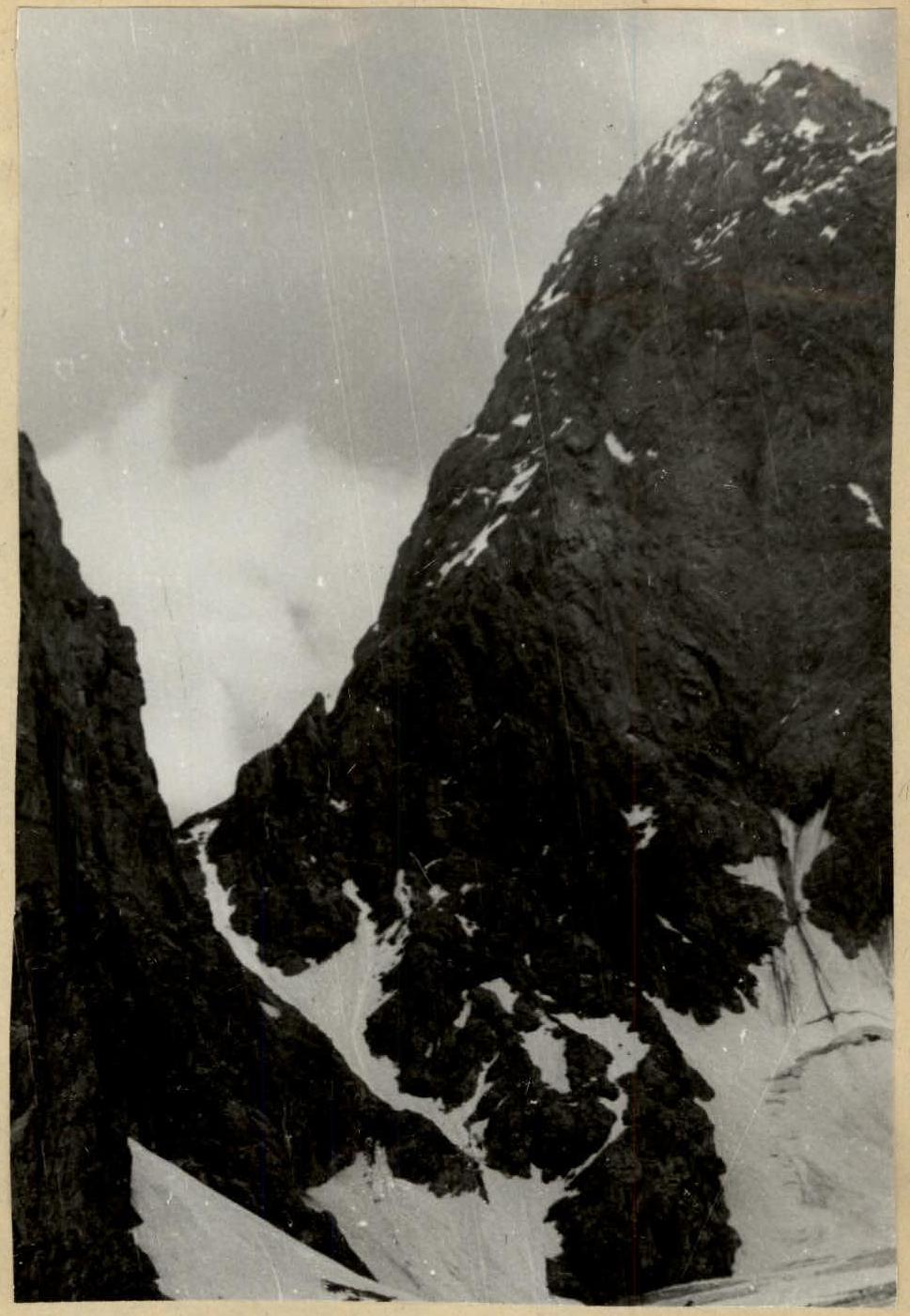
But as soon as we removed our backpacks and belayed them on the ropes, it immediately became more cheerful to trample out platforms on a rocky shoulder in the snow (see photo).
The mid-day snack with a sip of tea from a thermos had long been digested, and simple desires to have dinner and rest gave everyone new strength, and the bivouac was organized twice as fast as on the saddle.
At 20:00, there was communication with the observation group.
After dinner and admiring the beautiful sunset, we went to sleep. We discussed the direction of the group's movement the next morning and possible variants of our actions depending on the weather.
Day four — July 22, 1977 The overnight stay under the summit at a height of 4670 m passed well. The mood is elevated; the summit is nearby.
The team of Ivashev — Kratovich moves forward. By 8:00, the entire group is already gathered on the summit along the dirt ridge. While Markelov V. writes a note and we collectively build a cairn, the duo Ivashev — Nezamutdinov descends on a rope lower towards the White Sauk-Djaylyau and surveys the descent path along the southern slopes to the saddle. However, the significant steepness of this slope does not allow them to see the saddle.
Surveying:
- the ascent to the White Sauk-Djaylyau along the opposite slope
- the further path from White to Main Sauk-Djaylyau
- the return along the ascent path
We clearly see and feel that in the three days remaining until the control deadline, we will not complete this path. Therefore, considering the fact of deteriorating weather and the impossibility of extending the control deadline due to the complex mudflow situation in the region, we decided not to hurry and not to make the traverse but to descend along the Eastern ridge — well-examined the day before. Undoubtedly, the decision was also influenced by the previous events involving the Uzbek climbing team and our impressions from the descent from the Eastern Sauk-Djaylyau along the southern slopes when we were reconnoitering the object for the USSR Championship.
Out of twelve descents using "dülfer," seven were organized on pitons.
The 80-meter ropes were a great help; on shorter ones, we repeatedly found ourselves hanging, not reaching the platform.
Many group members encountered such a complex descent for the first time, not counting the descent from the Eastern Sauk-Djaylyau.
Such a stepped structure of the ridge, composed of individual towers, is not visible from below, and the towers, overlapping each other, give the impression of a not-so-steep ridge, which, apparently, the Uzbek climbers did not take into account.
The complexity of the descent overshadowed the impressions of the previous days and the complexity of the ascent.
And if we were not equipped with reliable pitons and pitons for "dülfer," it is hard to say how our descent would have ended.
Already on the glacier, each of us for the second time drew the attention of comrades to the peculiarity of this cirque: here, peaks do not have simple paths, even of the 4th category of difficulty.
And while having dinner, and while settling in for the night on the saddle between the Eastern and South-Eastern Sauk-Djaylyau, and many times later, we could not stop marveling at:
- the strange and very peculiar structure of the slopes of the peaks in this region
- the lichens on the rocks, especially after rain, which we will remember as one of the biggest dangers on the climber's path to the summit
Day five — July 23, 1977
- At 7:00, the team of Nezamutdinov — Ivashev heads out to the route and removes 140 m of fixed rope left after processing.
- At 10:00, the entire group hastens to descend from the saddle before the sun illuminates these slopes and spontaneous rockfall begins.
- We cross the glacier and finally arrive at the assault camp.
- We meet our faithful helpers — observers.
- Stories, impressions, what they saw, what we saw, and who and how heard during countless communications via "Nedra" radios in the previous days.
- Tea drinking sessions alternate with lunch, and conversations do not end.
- Finally, the command: "Pack up!" and we descend to the base camp, along the way removing fixed ropes at complex sections.
- Here, too, we are awaited with impatience.
- Endless conversations, congratulations, debriefings — official and unofficial, forecasts for the future.
7. Overall assessment of the participants' actions during the ascent
During the ascent to the South-Eastern Sauk-Djaylyau peak, all participants performed well, confirming their right to participate in the USSR Championship.
Comparing this ascent with the previous first ascent to the Eastern Sauk-Djaylyau, it can be noted that the group worked like a well-tuned mechanism: the lead climber did not have to wait for the arrival of a free end of the rope, pitons, and carabiners from below. All group members understood each other without words, which was somewhat surprising given that the team included athletes from two different collectives:
- Leningrad Polytechnic Institute
- Mining Institute
Everyone worked together and harmoniously, and managed to accomplish a volume of work that would take less cohesive and experienced teams several days to complete.
 Route profile
TABLE OF MAIN ROUTE CHARACTERISTICS

| Date | Designation | Average steepness, in degrees | Length, in m | Character of relief | Difficulty | State | Weather conditions | Rock pitons | Ice pitons | Pitons for "dülfer" |
|---|---|---|---|---|---|---|---|---|---|---|
| 20.07.1977 7:00–10:45 | 1 | 47° | 400 | Snow slope, couloir | 2 | Rockfall hazard | good | |||
| 14:00 | 2 | 35° | 120 | Ice slope | 2 | good | ||||
| 3 | 45° | 40 | 3 | 3 | ||||||
| 4 | 60° | 60 | Edge | 5 | Destroyed, iced | 4 | ||||
| 5 | 65° | 60 | Wall | 5 | Monolithic | 3 | ||||
| 6 | 70° | 120 | Wall, chimney | 5 | Monolithic, |