ASCENT DOCUMENT
- Ascent classification — technical
- Region — Pamir-Alay
- Sauk-Jaylau (Main) via the northern wall bastion
- Proposed — 6B category of difficulty, first ascent
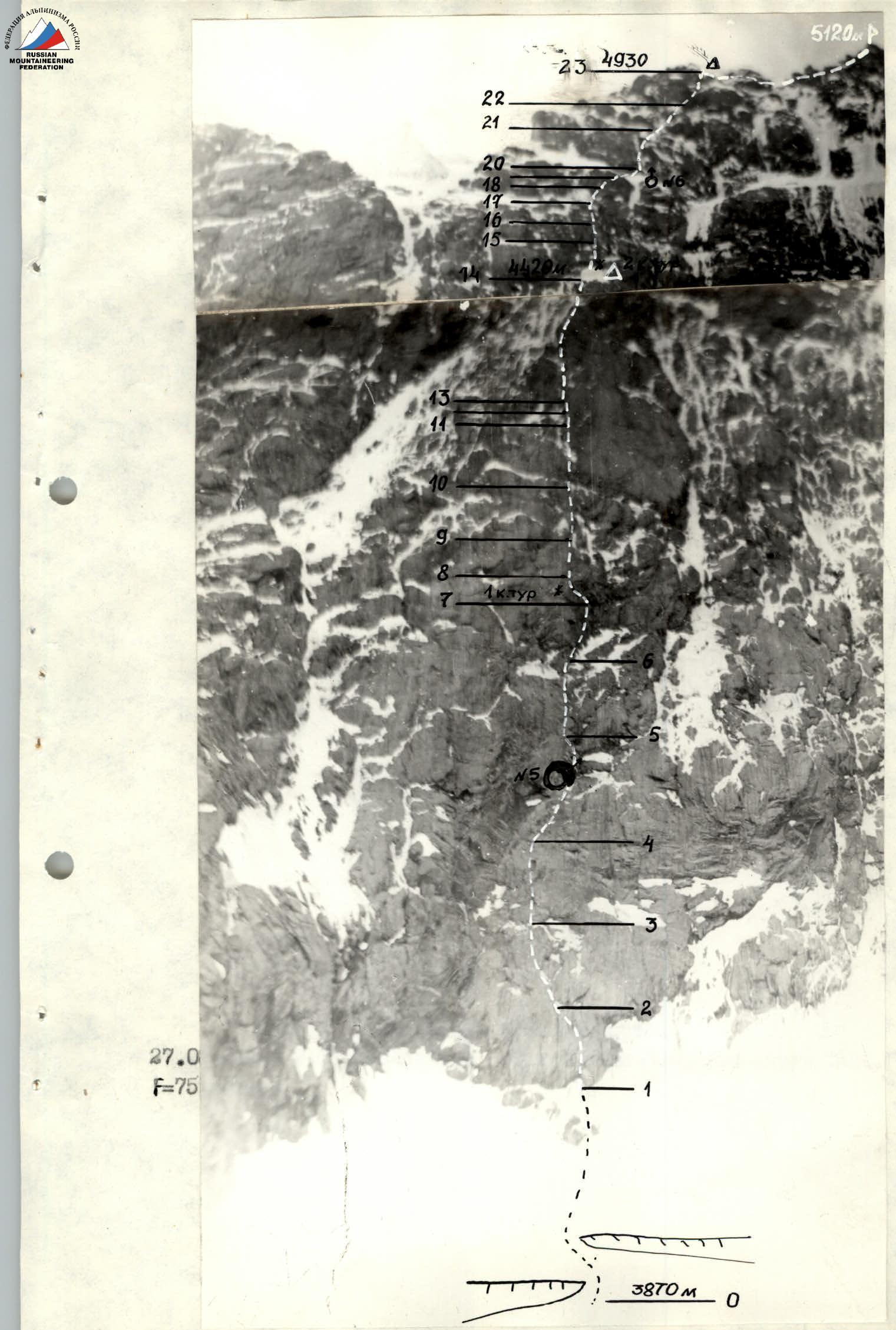
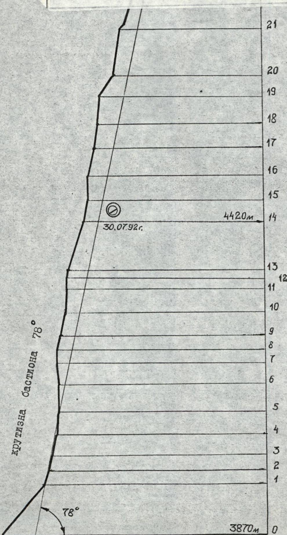
- Height difference – 1250 m, length – 1495 m, wall section – 975 m, average steepness of the wall section – 78°. Length of sections with 5–6 category of difficulty – 935 m (3960–4930), including 6 category of difficulty – 405 m (4010–4460)
- Pitons driven
| Rock | Bolt | Nuts | Ice |
|---|---|---|---|
| 121 | 0 | 123 | 20 |
| 18 | 30 | 0 |
- Team's working hours: 41.5 hours and days – 5
- Overnights: 1st – on a snow drift, in a tent; 2nd – on a ridge in a tent
- Team leader: Ostanin Viktor Vasilyevich MS
Team members:
- Bruk Mikhail Alexandrovich MS
- Donskikh Mikhail Fedorovich MS
- Devi Mikhail Mangrenovich MS
- Klenov Alexander Valeryevich MS
- Kolesov Alexander Petrovich MS
- Coach: Borisov Sergey Viktorovich
- Approach to the route: July 27, 1992
Summit: August 1, 1992. Return: August 1, 1992
Photo 2. Left wall profile. July 28, 1992, 10:00, lens T-22, F=75, distance 0.8 km, height 3950 m, shooting point 2. (Down from the ski pole handle, a blurred strip is visible – a plumb line)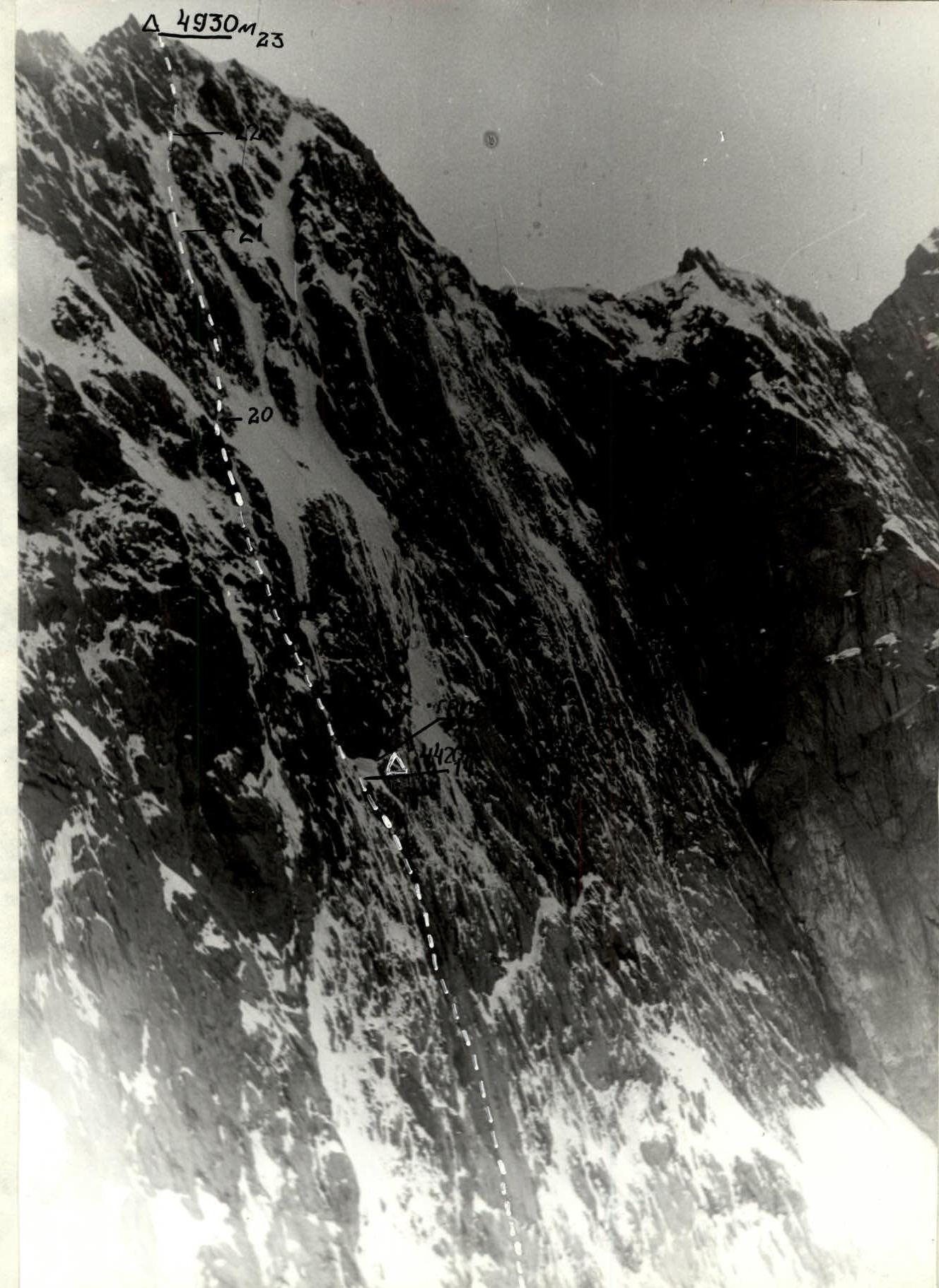
Photo 3. Fragment of the left profile, sections R18–R23. July 24, 1992, 9:00, lens T-22, F=75, distance 1 km, height 4500 m, point 3. The photo was taken from the route to Sauk-Jaylau (SE).
AREA MAP OF THE ASCENT.
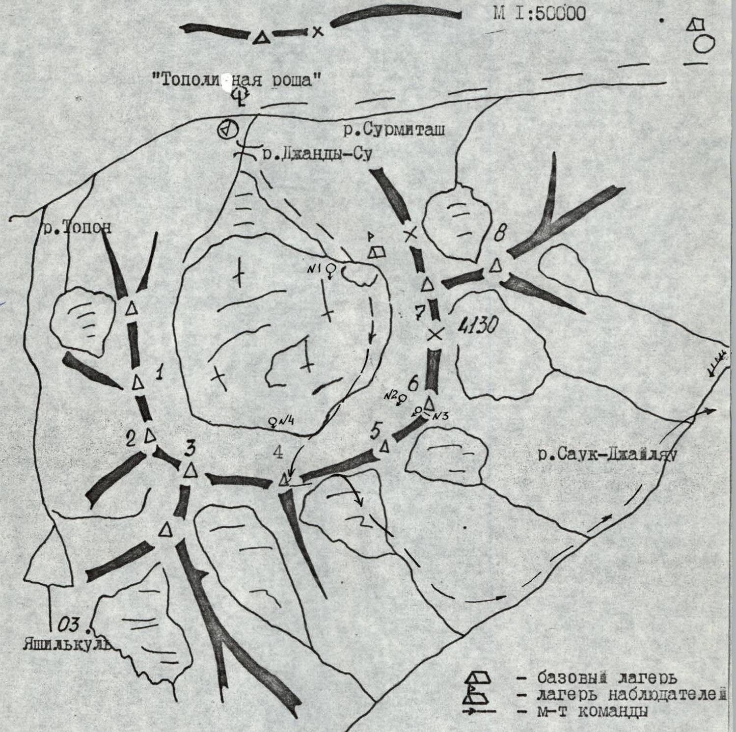
- Sauk-Jaylau (West) I tower.
- Sauk-Jaylau (West) II tower.
- Sauk-Jaylau (Central)
- Sauk-Jaylau (Main)
- Peak White
- Sauk-Jaylau (South-East)
- Sauk-Jaylau (East)
- Dvuzubka.
PREPARATION FOR THE ASCENT
The sports team composition was determined in November 1991, after the competition results and the "Alpinist of the Season" contest, held by the Sverdlovsk Alpinism Federation. The coaching council also discussed possible ascent objects based on tasks and financing possibilities. After discussing options for Ak-Su, Karavshin, Guamysh, and Archa-Kanysh, it was decided to study the Archa-Kanysh area in more detail as a promising but long-forgotten region in sports terms.
Team members Borisov S. and Bruk M. visited the Dugoby area twice during the winter and, after studying the KSP card index, proposed the Sauk-Jaylau massif, on which routes of 5B and 6A categories of difficulty were laid out as part of the Russian Championship and CA. The northern and western walls of the massif are comparable to Guamysh and the walls of the Ak-Su area, and a more detailed study of photographic materials and consultations with Yakovlev V.D. and Gromov L.E. left hope for finding a first ascent there.
In early July, the team arrived in Archa-Kanysh, and the Klenov-Donskikh team immediately went under the Sauk-Jaylau massif to clarify the route and observe. Reconnaissance showed that the planned bastion of the northern wall was not just interesting but problematic to pass: northern exposure, i.e., the bastion is practically never in the sun, hence cold rocks filled with ice; the route is very steep, around 80°; there are two cornice belts that cannot be avoided; and lastly, there is only one place on the bastion to set up a tent – the "mushroom", all other overnight stays will be hanging. However, the bastion is safe from seracs, the rocks are quite strong, and the choice was made.
Within 20 days, team members in various groups made ascents of 5B and 6A categories of difficulty, including to Sauk-Jaylau (SE), from where the championship route was studied and photographed in detail (Photo 3).
On July 25, team members passed physical and technical training standards according to FA requirements. A comprehensive analysis of the route allowed for two options for its passage, depending on weather conditions and the state of the rocks. A rescue team was formed in the base camp during the ascent, with the right to go on the 6B category route, equipped with gear. To obtain detailed information from the team, a radio station of type RTP-2 was prepared – "wall – observation", and light and sound signaling were also agreed upon. "Observation" could, in turn, contact the rescue team in the base camp and KSP "Pamir-Alay" to call, if necessary, a rescue helicopter.

July 27–31, August 1. Days. — bad weather
TACTICAL ACTIONS OF THE TEAM
The team's movement along the route was carried out in accordance with the backup tactical plan. The route was completed in 5 days. On July 26, the team went on the approach.
On July 27, it became clear in the morning that the weather was deteriorating, and it was decided, according to the backup tactical plan, to start processing the route. Ostanin-Kolesov went on processing, by 14:00 they passed 3 ropes on ice and processed 2 ropes of rocks (section R0–R2), then it started snowing, and the pair descended.
On July 28, at 9:15, Klenov-Bruk went on processing. The weather was cloudy but dry. Closer to lunch (11:30), wet snow started falling. They passed 4 ropes (section R3–R6) and were replaced by Donskikh-Davi, who processed another two ropes (section R6–R9). The cornices were passed (Photo 5), i.e., the main problem of the bastion was solved, and the whole team's departure was scheduled for the next morning.
July 29 – wet snow is falling all morning, the entire wall is in streams of water and snow. They decided to wait.
July 30 – cloudy but cold, sometimes graupel falls, water on the rock has frozen. The team decided to go. Klenov-Ostanin went ahead: they passed the processed ropes, then another 3 (section R10–R13) and by 16:00 reached the "mushroom" – the planned overnight spot. Part of the "mushroom" was cut off, part was glued, and a six-person double tent fit perfectly on this spot. During the construction, tea and a snack were prepared. After refreshing themselves, Donskikh and Davi went on processing. By 22:00, they hung another 3 ropes. The weather finally showed mercy – it became clear and cold.
July 31 – the previous pair went ahead, they found a way and are eager to go up. After 9 ropes, we are on top of the bastion. Ahead are 1.5 ropes of ice-snow, and then rock roofs, which were passed by 18:00. We are on the ridge. We set up a tent. Ahead is a sharp, destroyed ridge. By evening, Kolesov managed to hang another 3 ropes along it to save time and energy the next day.
On August 1, at 8:00, we depart lightly. The ridge is about 4 km, within 3 hours – on the summit. Descent along the ascent path to the tent, then along the ridge to the pass between Sauk-Jaylau (Main) and Peak White, further south to Sauk-Sai. At 23:00, the team returned to the base camp in full.
Thus, the ascent was completed. Despite bad weather, the extremely difficult route was completed without deviations from the planned plan thanks to the correct tactics, i.e., during the period of bad weather, leaders changed and processed the route, knowing they would come to dry tents, change clothes, and have a hearty dinner. And at the first signs of improving weather, the rested team quickly worked out the remaining part of the route.
Work on the route was carried out in the mode of 8–12 hours (including processing) and 8 hours of rest daily. The route took 41.5 hours.
The safety of the ascent was ensured by:
- The correct choice of route, as the bastion is somewhat distant from the wall, rocks and ice fly to the right and left.
- The presence on the route of a convenient and safe place to spend the night in a tent.
- Regular change of leaders by days and during one day (all team members worked at the front).
- Work on a double rope with insurance according to UIAA-I using a wide range of equipment, including hook-legs, ice-phi-phi, etc.
- Passage of handrails with double insurance.
- Securing handrails and organizing stations in places protected from rockfall.
The team had:
- A set of medications necessary for emergency assistance.
- A radio station of type RTP-2.
Nutrition:
- Hot food was prepared twice a day.
- A pocket snack was issued per day.
- On the third day, in addition to hot meals during the day, tea was organized after prolonged and difficult work on passing 14 ropes of handrails.
During the ascent:
- All waste was burned or taken away.
- The route was left clean, all pitons were knocked out (except for two for securing control tours).
- There were no falls or injuries on the route.
To Sauk-Jaylau (Main) via the northern wall bastion. Scale 1:2000. Climbing hours 115.
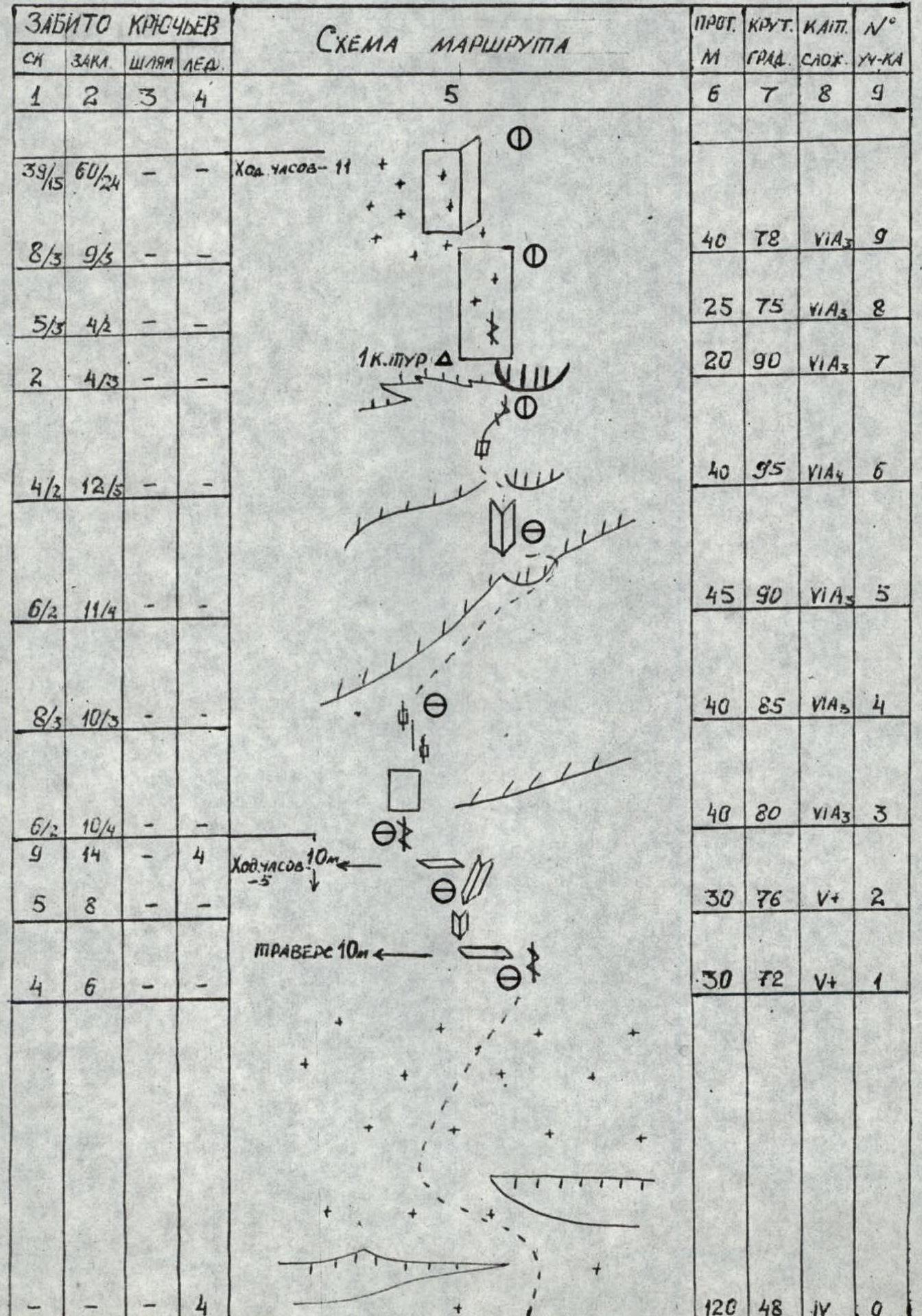
| Rock | Nuts | Bolt | Ice | Notes | Length (m) | Steepness (°) | Cat. diff. | Section № |
|---|---|---|---|---|---|---|---|---|
| 10 | 6 | - | 2 | 90 | 72 | 5 | R21 | |
| 8 | 9 | - | - | 80 | 80 | 5 | R20 | |
| - | - | - | 3 | 40 | 55 | 4 | R19 | |
| 4 | 5 | - | - | 45 | 85 | 5 | R18 | |
| 2 | 5 | - | 2 | 40 | 80 | 5 | R17 | |
| 3 | 6 | - | 2 | 45 | 76 | 5 | R16 | |
| 7 | 9 | 40 | 90 | 6 | R15 | |||
| 5 | 10 | - | - | 2 C.TOUR | 40 | 80 | 6 | R14 |
| 2 | 6 | - | 4 | 90 | 72 | 5 | R13 | |
| 6 | - | - | 1 | 15 | 80 | 5 | R12 | |
| 5/2 | 8/4 | - | - | 30 | 90 | 6 | R11 | |
| 4/1 | 11/2 | - | - | 40 | 85 | 6 | R10 | |
| 8/3 | 9/5 | - | - | 40 | 78 | 6 | R9 | |
| 5/3 | 4/2 | - | - | 25 | 75 | 6 | R8 | |
| 2 | 4/3 | - | - | 1 C.TOUR | 20 | 90 | 6 | R7 |
| 4/2 | 12/5 | - | - | 40 | 95 | 6 | R6 | |
| 6/2 | 11/4 | - | - | 45 | 90 | 6 | R5 | |
| 8/3 | 10/3 | - | - | 40 | 85 | 6 | R4 | |
| 6/2 | 10/4 | - | - | 40 | 80 | 6 | R3 | |
| 5 | 8 | - | - | 30 | 76 | 5 | R2 | |
| 4 | 6 | - | - | 30 | 72 | 5 | R1 | |
| - | - | - | 4 | Traverse 10 m | 120 | 48 | 4 | R0 |
DESCRIPTION OF THE ROUTE BY SECTIONS
| Section | Description |
|---|---|
| R0–R1 | Snow-ice slope |
| R1–R2 | Movement along monolithic rocks under an overhang |
| R2–R3 | Left to bypass the overhang |
| R3–R4 | Forehead with a series of crevices |
| R4–R5 | Unpleasant climbing, destroyed belt |
| R5–R6 | There is a passage in the cornice (Photo 5) |
| R6–R7 | Overhang, movement along an arc from left to right under the rock-cornice |
| R7–R8 | The rock-cornice is bypassed on the left, 1 category of difficulty |
| R8–R9 | Slab with good holds but icy |
| R9–R10 | Internal corner, movement along the left edge. Rime ice. |
| R10–R13 | Along the internal corner, which gradually overhangs. Rime ice. |
| R13–R14 | Icy slabs, bypassing the snow "mushroom" on the left, 2 control tours. |
| R14–R15 | Bypass the overhang along the left edge of the corner. Rime ice. |
| R15–R16 | Internal corner. Ice, icicles hang. |
| R16–R19 | Icy rocks. From under the cornice, a pendulum to the right edge of the corner with an exit to the snow-ice slope. |
| R19–R20 | Snow-ice slope |
| R20–R23 | Up along the internal corners-gullies with ice and snow (Photo 6) |
| R23–R24 | Severely destroyed ridge. Summit. |