-
The ascent category is technical.
-
The ascent area, ridge - Pamir-Alay, Alay ridge
-
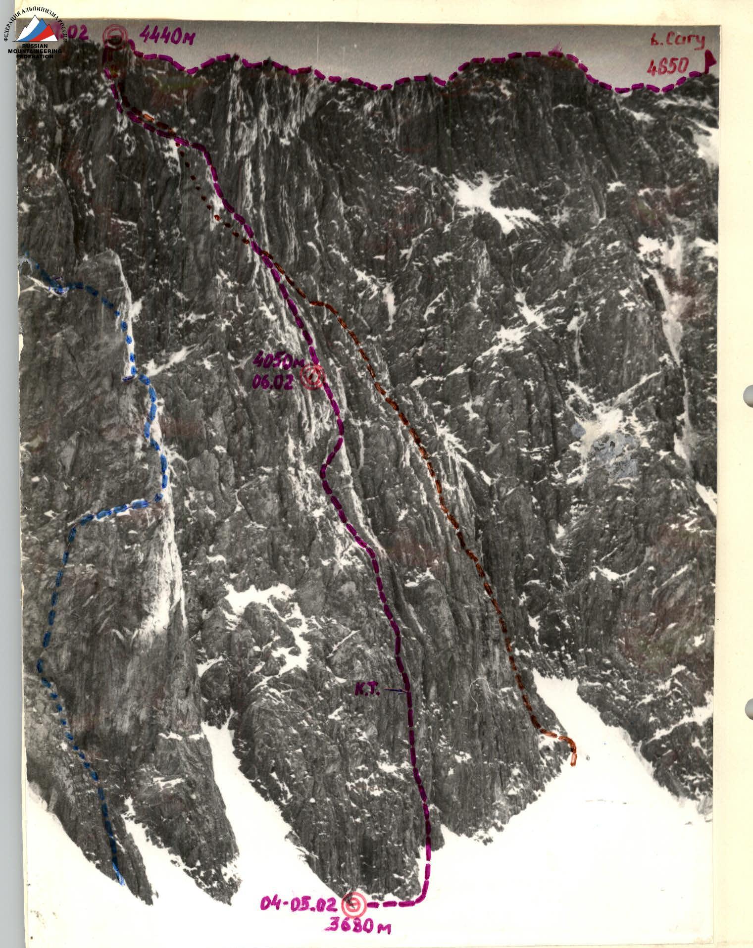
The summit, its height, ascent route - peak SAGU (4650 m), first ascent via the left part of the NW wall and N ridge.
-
The proposed difficulty category is 5B
-
Route characteristics:
height difference - 970 m, wall part - 730 m, length - 1446 m, wall part - 796 m, sections of 5-6 difficulty category - 606 m, average steepness of the wall part - 65°
-
Pitons hammered:
- rock: for belaying - 68, for ITO - 8
- placed protection: for belaying - 154
-
Number of climbing hours - 31.5 (including 10 hours of processing)
-
Number of bivouacs and their characteristics:
1st - semi-reclining; 2nd - lying on the ridge.
- Full name of the team leader, participants, and their qualification:
- Moshchnikov Anatoly Ivanovich, Master of Sports - captain
- Barulin Boris Alexandrovich, Master of Sports
- Beylin Yuri Iosifovich, Candidate for Master of Sports
- Savin Boris Nilovich, 1st sports category
- Karol Andrey Igorevich, 1st sports category
- Senior team coach - Troshchinenko L. A., coach - Beylin Yu. I.
- Date of departure and return: February 4-8, 1982
 route to Dvuzubka via the "pillar" of the N ridge 5B category
route to Sagu via the "feathers" of the N ridge 5B category
route of the first ascent group
route to Dvuzubka via the "pillar" of the N ridge 5B category
route to Sagu via the "feathers" of the N ridge 5B category
route of the first ascent group
Brief description of the approach to the route
From Fergana, a highway stretches into the mountains through Hamzaabad (Shakhimardan), Iordan settlement to the Alplager "Dugoba", located on a rocky terrace (about 3 hours drive).
From the camp, a trail winds up the Surmetapdavan river valley among dense forest thickets. At the confluence of the Ulitor river (right tributary) and Surmetapdavan, the mountains seem to part, and the trail splits:
- The right path leads to the mouth of the Aktash river, flowing into Surmetapdavan, bypassing peak Selsky (about 2.5 hours walk).
- From the confluence - to the left side of the Aktash river through a canyon and through the second canyon to the Urtalik glacier (see the ascent area map).
Along the glacier, via the left randkluft to the bivouac at the foot of the North ridge of peak Sagu (2.5-3 hours from the confluence).
Our group left the "Dugoba" camp at 16:00 on February 3, 1982, and stopped for the night at a kosch at the confluence of the Ulitor and Surmetapdavan rivers after 1.5 hours. On February 4, leaving the kosch at 8:00, the group reached the bivouac under the Northwest wall of peak Sagu by 11:00.
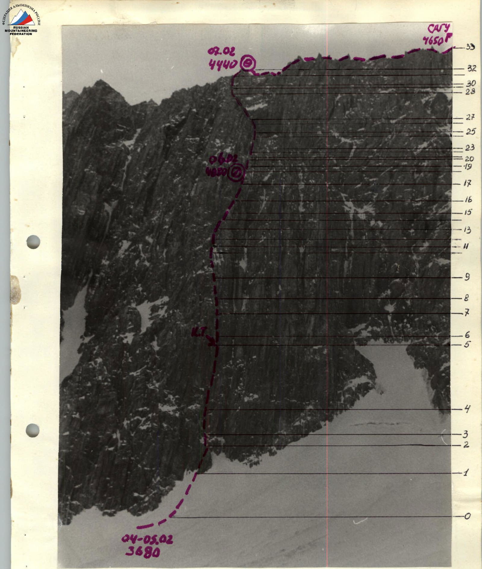
General view of the first ascent route on peak Sagu via the left part of the NW wall and N ridge
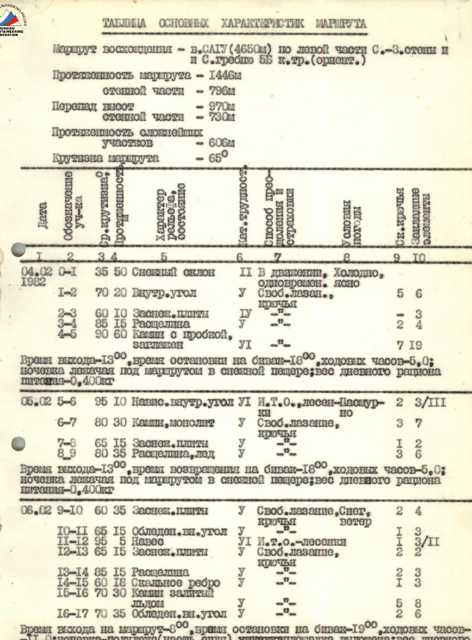
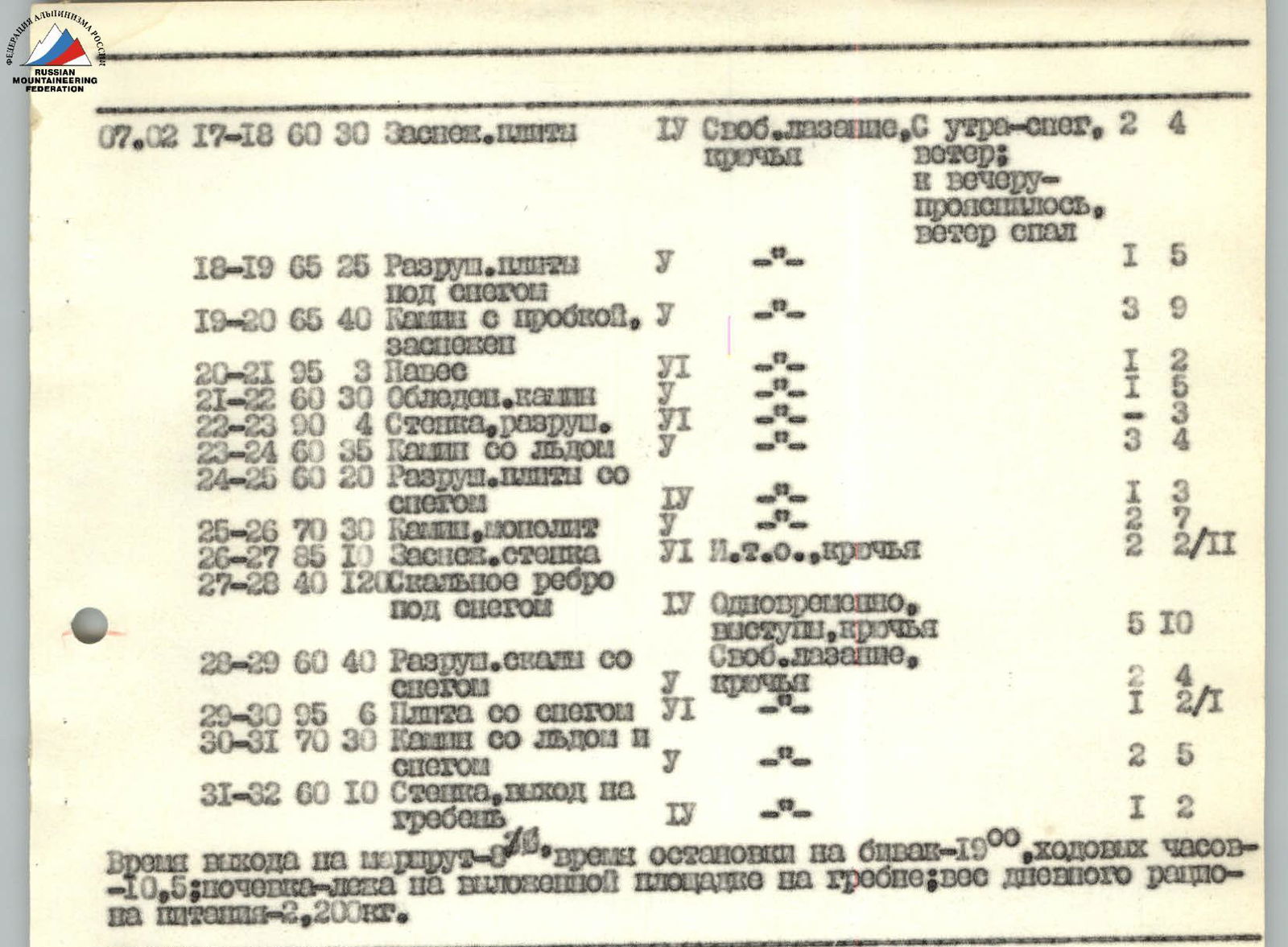
Table of the main route characteristics
Ascent route - peak SAGU (4650 m) via the left part of the NW wall and N ridge 5B category (orient.)
Route length - 1446 m wall part - 796 m Height difference - 970 m wall part - 730 m Length of the most difficult sections - 606 m Route steepness - 65°
| Date | Section designation | Length (m) | Steepness (°) | Terrain character, condition | Difficulty category | Passage process, belaying | Weather, well-being | Pitons | Protection elements |
|---|---|---|---|---|---|---|---|---|---|
| 04.02.1982 | R0–R1 | 35 | 50 | Snow slope | 2 | In motion, simultaneous | Cold, clear | ||
| R1–R2 | 70 | 20 | Inner corner | 5 | Free climbing, pitons | 5 | 6 | ||
| R2–R3 | 60 | 10 | Snow-covered slabs | 4 | 3 | ||||
| R3–R4 | 85 | 15 | Crevice | 2 | 4 | ||||
| R4–R5 | 90 | 60 | Chimney with a plug, smoothed | 6 | 7 | 19 | |||
| Departure time - 13:00, time to stop for bivouac - 18:00, climbing hours - 5.0; bivouac lying under the route in a snow cave; weight of daily food ration - 0.400 kg. | |||||||||
| 05.02 | R5–R6 | 95 | 10 | Overhanging inner corner | 6 | ITO, ladders | Cloudy | 2 | 3/111 |
| R6–R7 | 80 | 30 | Chimney, monolith | 5 | Free climbing, pitons | 3 | 7 | ||
| R7–R8 | 65 | 15 | Snow-covered slabs | 1 | 2 | ||||
| R8–R9 | 80 | 35 | Crevice, ice | 3 | 6 | ||||
| Departure time - 13:00, time to return to bivouac - 18:00, climbing hours - 5.0; bivouac lying under the route in a snow cave; weight of daily food ration - 0.400 kg. | |||||||||
| 06.02 | R9–R10 | 60 | 35 | Snow-covered slabs | 5 | Free climbing, pitons | Snow, wind | 2 | 4 |
| R10–R11 | 65 | 15 | Icy inner corner | 5 | 1 | 3 | |||
| R11–R12 | 95 | 5 | Overhang | 6 | ITO-ladders | 3/11 | |||
| R12–R13 | 65 | 15 | Snow-covered slabs | 5 | Free climbing, pitons | 2 | 2 | ||
| R13–R14 | 85 | 15 | Crevice | 2 | 3 | ||||
| R14–R15 | 60 | 18 | Rocky rib | 5 | 1 | 3 | |||
| R15–R16 | 70 | 30 | Chimney, filled with ice | 5 | 8 | ||||
| R16–R17 | 70 | 35 | Icy inner corner | 5 | 2 | 6 | |||
| Departure time on the route - 8:00, time to stop for bivouac - 19:00, climbing hours - 6.0; bivouac - semi-reclining (partly sitting); platform laid out; weight of daily food ration - 2.200 kg. | |||||||||
| 07.02 | R17–R18 | 60 | 30 | Snow-covered slabs | 5 | Free climbing, pitons | Snow in the morning, clearing up by evening, wind died down | 2 | 4 |
| R18–R19 | 65 | 25 | Destroyed slabs under snow | 5 | 1 | 5 | |||
| R19–R20 | 65 | 40 | Chimney with a plug, snow-covered | 5 | 3 | 9 | |||
| R20–R21 | 95 | 3 | Overhang | 6 | 1 | 1 | |||
| R21–R22 | 60 | 30 | Icy chimney | 5 | 2 | 2 | |||
| R22–R23 | 90 | 4 | Wall, destroyed | 6 | 3 | 3 | |||
| R23–R24 | 60 | 35 | Chimney with ice | 3 | 4 | ||||
| R24–R25 | 60 | 20 | Destroyed slabs with snow | 4 | 1 | 2 | |||
| R25–R26 | 70 | 30 | Chimney, monolith | 5 | 2 | 2 | |||
| R26–R27 | 85 | 10 | Snow-covered wall | 6 | ITO, pitons | 2 | 2/11 | ||
| R27–R28 | 40 | 120 | Rocky rib under snow | 5 | Simultaneous, outcrops, pitons | 5 | 10 | ||
| R28–R29 | 60 | 40 | Destroyed rocks with snow | 5 | Free climbing, pitons | 2 | 4 | ||
| R29–R30 | 95 | 6 | Slab with snow | 5 | 1 | 2/1 | |||
| R30–R31 | 70 | 30 | Chimney with ice and snow | 5 | 2 | 5 | |||
| R31–R32 | 60 | 10 | Wall, exit to the ridge | 5 | 1 | 2 | |||
| Departure time on the route - 8:00, time to stop for bivouac - 19:00, climbing hours - 10.5; bivouac - lying on a laid-out platform on the ridge; weight of daily food ration - 2.200 kg. | |||||||||
| 08.02.1982 | R32–R33 | 600 | North ridge | 3 | Simultaneous, outcrops | Clear, calm | 2 | 5 | |
| Departure time - 8:30, on the summit - 13:00, in "Dugoba" camp - 21:00, climbing hours - 4.5; weight of daily food ration - 2.0 kg. |
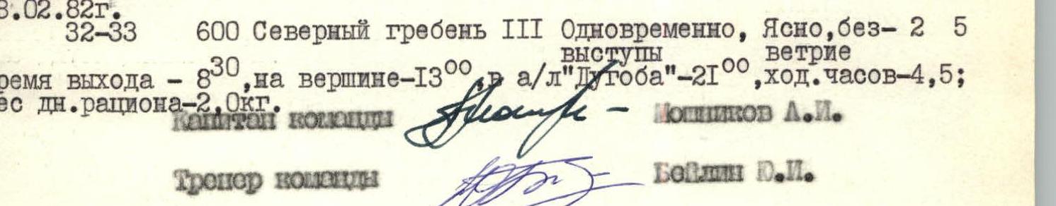
Team captain Moshchnikov L. I. Team coach Beylin Yu. I.
Route passage order
(Brief explanations for the table of main characteristics)
February 4. By 11:00, the group finished the approach and was under the wall. The Moshchnikov-Savin pair prepares to start processing, Barulin observes the wall and then the processors, Beylin and Karol prepare food and dig a cave. At 13:00, the pair starts processing. The approach is via a snow slope, steep in the upper part, to the base of an inner corner left of a narrow couloir separating the central part of the wall. Moshchnikov works first. The R1-R2 section is complicated by an exit to snow-covered slabs (R2-R3) at the top. Further, via a crevice (R3-R4), to the base of a narrow chimney with a plug (R4-R5). The chimney is smoothed, there are few cracks; when passing the plug, one has to hang out of the chimney. Then the chimney widens, and one needs to move to its edge. The chimney ends with an overhanging inner corner. Here, at the base of the corner, we secure a can with a note - a control tour. Processing is stopped for the day. In 5 hours, 100 m of complex rock is passed. Mostly monolith, many crevices are filled with ice, there are few holds; working without gloves was necessary. We descend to the cave.
February 5. At 12:00, the Barulin-Beylin pair goes for processing. Moshchnikov and Savin observe the wall and the processors; Karol handles radio communication, lunch, and packing supplies. The pair approaches the "processed" day before rope to the base of the inner corner (R5-R6). The middle part of the corner is passed on ladders. At the top: left - a wall, right - a huge smooth slab. We pass between them via a chimney (R6-R7), leading to snow-covered slabs (R7-R8). Via the slabs - to a crevice, steep, with ice inside (R8-R9), which again leads to snow-covered slabs. Here we secure the rope and leave the brought equipment. Tomorrow, we can continue work without delay. Down to the guys.
February 6. We rise early; the first pair, Savin-Karol, departs at 8:00, still quite dark. The next, with a 15-minute interval, depart Moshchnikov, Beylin, and Barulin in turn. From 8:00 to 12:00, we pass the processed section; the lower 3 ropes are dropped and picked up by Kuznetsov, Ivanov, and Mikhailov, who came to the cave the day before. They photograph the wall, observe us, and leave for down at 14:00. From the end of the processing, the path is visible in the direction of a huge inner corner filled with ice. Via snow-covered slabs (R9-R10) to the inner corner (R10-R11). Ice, cold; we have to hang ladders to pass the overhang (R11-R12) that blocks the inner corner. Further, via snow-covered slabs (R12-R13), we bypass the inner corner filled with ice, via a crevice (R13-R14) leading to a rocky rib (R14-R15). From here, the only possible path is via an icy chimney (R15-R16) that leads to an inner corner filled with ice. The chimney is complicated because the walls are smoothed; few holds are iced; the first one has to leave a backpack with puffy insulation.
Snowfall starts, complicating the already difficult climbing. Much time is spent warming hands. The inner corner leads to more dissected rocks; it's time to set up a bivouac, but there's no platform. We decide to dig out a bivouac site; Savin continues working further. On this day, we manage to pass another 55 m (R17-R19) via snow-covered rocks to a chimney. We struggle to stretch the tent, settling semi-reclining and sitting. Cooking dinner is done "outside." Snow continues throughout the night. Barulin couldn't withstand the discomfort and tried to settle outside the tent in the morning but couldn't sleep due to cold and woke the group at 7:00 with a hot breakfast.
February 7. At 8:30, the Moshchnikov-Beylin pair departs via the processed ropes. Snow continues to fall. The chimney (R19-R20) is not steep but complicated: cracks are filled with snow; it's very cold in the morning. At the top of the chimney, there's an overhang (R20-R21) passed via free climbing; there are good holds at the top. Further, another chimney (R21-R22). The rocks here are fragile; maximum caution is required to avoid bringing down snow on those below. We overcome a wall (R22-R23) and, via a chimney with ice (R23-R24), exit onto snow-covered slabs. The snowfall stops; the sun comes out, illuminating the tip of the ridge - our route is lit only at the exit to the ridge in winter. Another chimney (R25-R26) leads to a snow-covered wall (R26-R27), which is passed on ladders and leads to a rocky rib (R27-R28). Via destroyed, snow-covered rocks, we exit onto a small col (R28-R29). Here, our route converges with the route via the "feathers"; we find a control tour with a note. From here, via a slab, to a chimney with ice and snow (R30-R31), then a small wall, and we're on the ridge. We immediately find a platform for two. While we level and expand it, the rest of the group catches up. It's so pleasant to stretch out full length.
February 8. We depart at 8:30. Clear, no wind; visibility is excellent - the transparent winter air allows us to admire the panorama for many kilometers. The ridge is not complicated; we move simultaneously, using outcrops for belaying mostly. At 13:00, we're on the summit. We leave a note and start descending further along the ridge to the south. Eight sports rappels via a snow-ice couloir into the Aktash river valley, and after 4.5 hours, we're at the Aktash bivouac. Without delay, we continue descending and arrive at the "Dugoba" camp at 21:00.

Route sketch in UIAA notation