Alpinist group from "Dugoba" camp. Material on the first ascent of the route
Technical category, leader - ZINOVIEV G.N., team commander - VERBITSKY G.G.
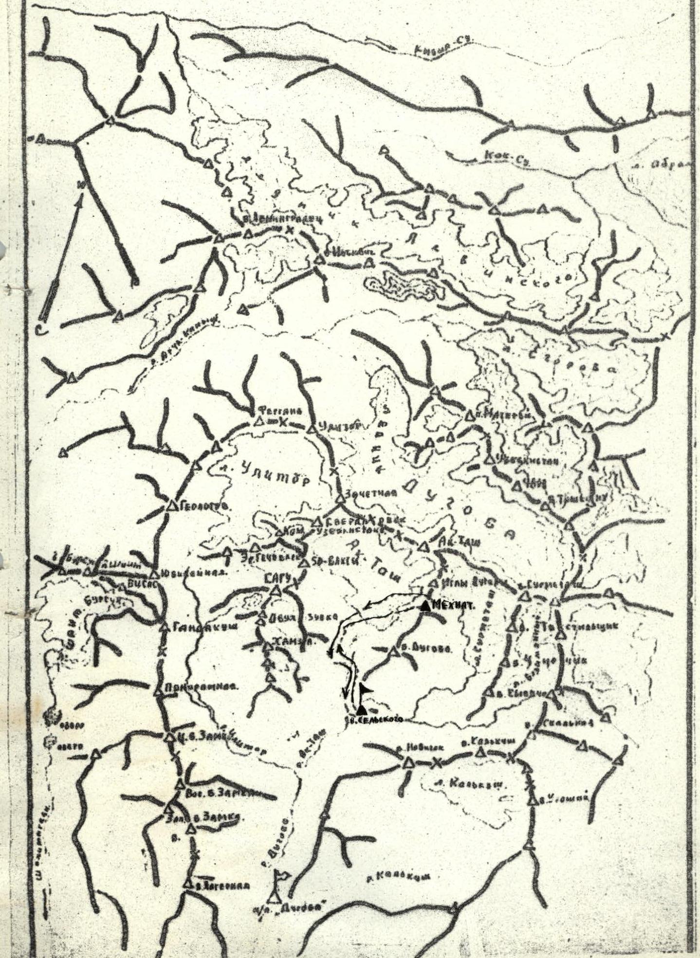
Peak Mekhnat is located in the Pamir-Alay region between the Ak-Tash and Surmitash-Davan glaciers.
Ascent plan to Mekhnat on July 25, 1976: July 24, 18:00 - Ascent to Upper Ak-Tash overnight stay July 25, 5:00 - Departure under the north-eastern ridge 6:00 - Approach to the first control cairn 14:00 - Ascent to the summit 16:00 - Return to the base camp
Route description
The route begins on a scree slope, leading to a rocky ridge (see photo). At the start of the route, on a horizontal shelf, a cairn marks the beginning of the route. From the start to the I control cairn, there are 80 meters of difficult climbing on rock - the section corresponds to 4A category, average steepness 70-80°, insurance is via pitons, rocks are of the smoothed "ram's foreheads" type (section # I).
From the first control cairn, the movement is simultaneous along a heavily destroyed, crumbling ridge - 40 meters to a wall (section # 2). Further, 120 meters along the wall and an inclined shelf from left to right, leading under a reddish wall, with a wide shelf at the bottom.
Section 4A category - average steepness 80-85° (section # 3).
Next, passage along the wall from left to right and along a diagonal chimney, with exit under a reddish wall on the right side of the ridge. There is a plug in the chimney. Under the reddish wall, there is a shelf. All shelves are generally convenient for accommodating 2-3 participants and for insurance.
On this section # 4, climbing corresponds to 4A category, insurance is via pitons, steepness of the section is up to 70-75°, length of the section is 60 meters.
Section # 5: the reddish wall is ascended on the left side (60 meters), climbing is difficult, insurance is via pitons, exit to the ridge on slabs with diagonal cracks under a vertical section. Further, 40 meters along inclined slabs and a chimney on the right side of the ridge lead to a wide, horizontal, scree-covered shelf, on which the II control cairn is located.
The total length of the 5th section is 100 meters, climbing is difficult with piton insurance, steepness is 80-85°. In the chimney, climbing is "in camming".
Section # 6: along a wide, scree-covered shelf, 10 meters to the right and up the wall, 40 meters - climbing is very difficult, steepness is 85-90°, corresponds to 4B category. For insurance, snap-link hooks are used. The wall is very crumbly. Further, 40 meters along the ridge to a wide, horizontal, scree-covered shelf, which connects, via a snowy corridor, two routes - 4B category and our route. On the shelf, there is snow.
Section # 7: after the scree-covered shelf, 80 meters to the pre-summit ridge, the route follows a wall with a steepness of 85-90°, climbing is difficult, corresponds to 4B category. The last 120 meters - the key section, steepness of the section is 90-85°, section 4B category.
Total route length - 690 meters. 47 rock pitons were hammered in on the route (very usable snap-link hooks).
List of participants and overall assessment of each member's actions
| № | Name | Year of birth | Category |
|---|---|---|---|
| 1. | Zinoviev G.N. | 1945 | 1st sports category |
| 2. | Neverov V.N. | 1942 | 1st sports category Kamchatka |
| 3. | Goncharenko P.S. | 1951 | 1st sports category |
The North-Eastern ridge of Mekhnat was ascended by the group without errors. The group was physically and technically well-prepared.
List of equipment for 4 people
| № | Name | Quantity / Length |
|---|---|---|
| 1. | Main rope | 3 pcs. x 40 m |
| 2. | Rock hammers | 2 pcs. |
| 3. | Rock pitons | 16 pcs. |
| 4. | Carabiners | 10 pcs. |
| 5. | Auxiliary rope | 20 m |
TEAM LEADER Zinoviev (G. ZINOVIEV)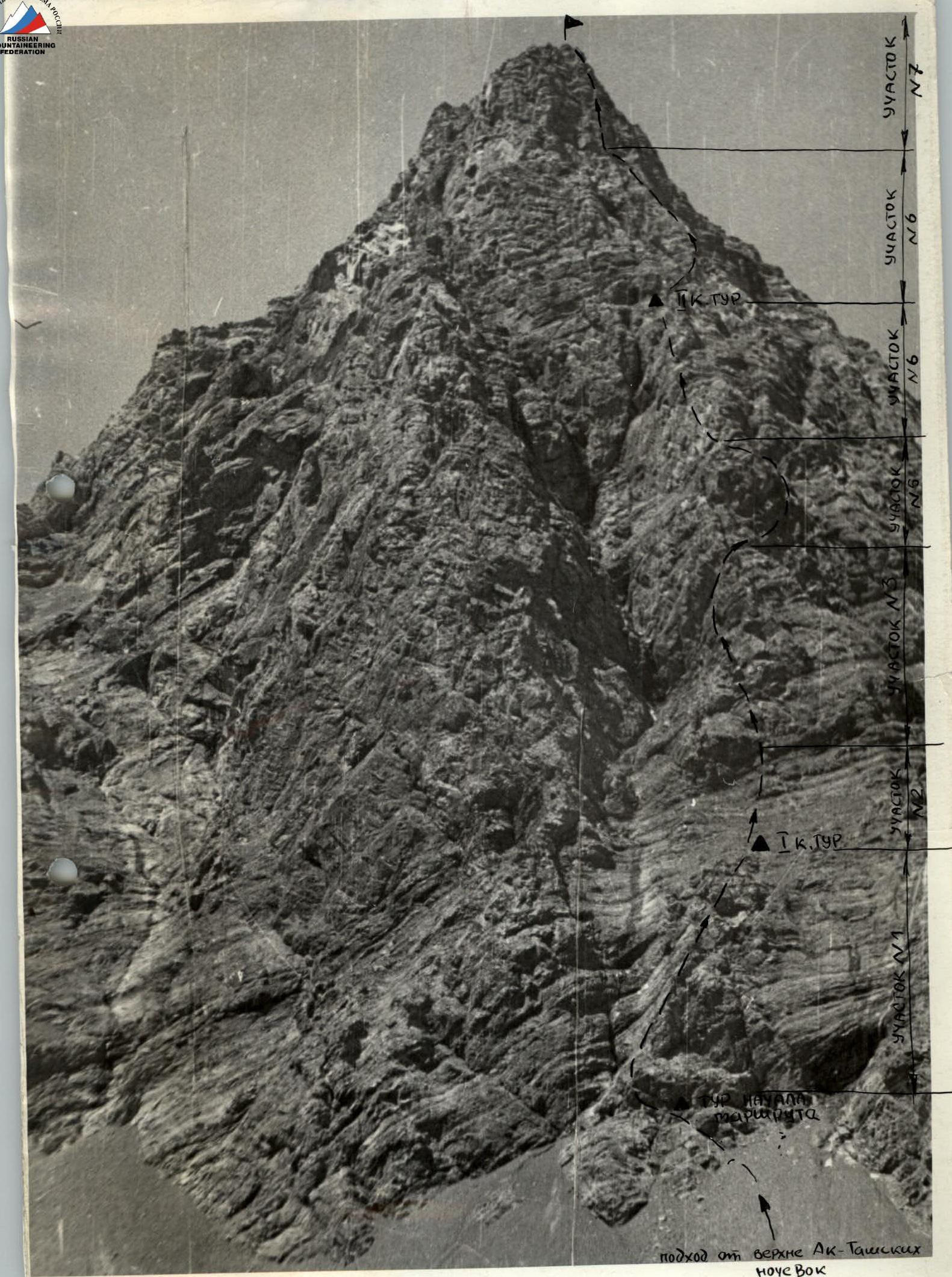 Peak Mekhnat 4A category
Map-diagram. Pamir-Alay